Mesozoic and Cenozoic extension in the offshore portion of the Bohai Bay Basin
Over the past two decades, a number of articles have addressed the Cenozoic evolution of the Bohai Bay Basin (Ye et al., 1985; Wang et al., 1985; Liu, 1987; Hong, 1989; Zhao and Windley, 1990; Allen et al., 1997; Hu et al., 2001; He and Wang, 2003; Zhao and Zheng, 2005). To date, attempts at a reconstruction of the Mesozoic basin have been limited. The crustal thickness of the offshore portion (Bohai Sea) of the Bohai Bay Basin is the thinnest within the NC, suggesting that the offshore portion of the basin is a region of importance in the destruction of the NC.
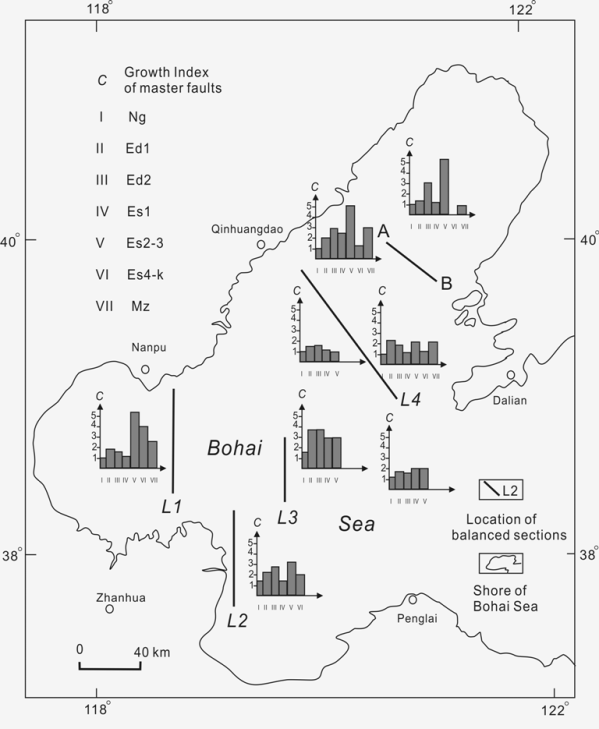
The growth faults that define the depression boundaries of the basin are major extensional structures. The growth faults controlled sedimentation and the migration of the depositional depocenter. The depocenters of the Bohai Bay Basin moved from the margins of the basin to the center of Bohai Sea in the period from the Early Tertiary to the Late Tertiary. C-frequency (C being the thickness ratio of a layer in the hanging wall to the same layer in the foot wall for master fault) diagrams of growth faults were constructed from local seismic sections from the Bohai Sea. The C-frequency diagrams (Figure 5) further indicate that, in the Oligocene and Miocene, the growth faults in the center and east of the sea were more active than the faults near the margins of Bohai Sea (Figure 5), an observation consistent with migration of the depocenters from the margins to the center with continued extension.
Figure 5. Locations of C-frequency diagrams and the balanced-cross sections in the offshore portion of the North China Basin
C is thickness ratio of a layer in the hanging wall to the same layer in the footwall for master fault; Mz-Mesozoic Formation; Es4-k-Eocene Shahejie Formation 4 and Kongdian Formation; Es2-3-Eocene Shahejie Formation 2 and 3; Es1-Eocene Shahejie Formation 1; Ed1-Oligene Dongying Formation 1; Ed2-Oligene Dongying Formation 2; Ng-Miocene Guantao Formation; Nm-Miocene Minghuazhen Formation.
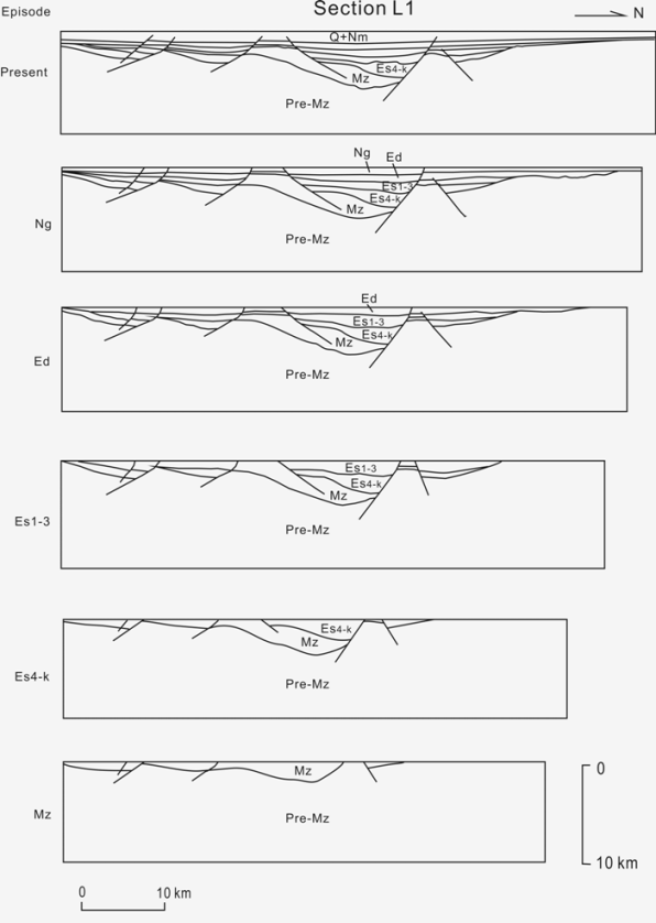
We chose four representative interpreted seismic sections (L1, L2, L3and L4) that cross the orientation of the master faults in Bohai Sea, the offshore portion of the Bohai Bay Basin (Figure 5). Balanced cross-sections were analyzed following correction for the compaction curves and thermal subsidence based on the well data and an interpreted thermal history, with the depth (c. 12.6 km) of detachment for the basement faulting calculated from earthquake source depths (Ma and Liu, 1986). The method of Gibbs (1983) was used for construction of the balanced cross-sections. A representative balanced cross-section is shown in Figure 6. Extension estimates for four sections in different periods are presented in Table 1 and indicate the relative intensity of extension in the Mesozoic and Cenozoic. One section gives an extension estimate of 13.7% for the Late Mesozoic time, which is similar to the magnitude of extension in the Late Eocene and Oligocene (Es1-3 and Ed). This suggests that the offshore portion of the basin witnessed major extension in the Late Jurassic and Early Cretaceous.
Figure 6. Evolution of an offshore balanced section (L1)
Pre-Mz-Pre-Mesozoic Basement; Mz-Mesozoic Formation; Es4-k-Eocene Shahejie Formation 4 and Kongdian Formation; Es2-3-Eocene Shahejie Formation 2 and 3; Es1-Eocene Shahejie Formation 1; Ed1-Oligene Dongying Formation 1; Ed2-Oligene Dongying Formation 2; Ng-Miocene Guantao Formation; Nm-Miocene Minghuazhen Formation; Q-.
Table 1. The extension calculation of four balanced cross-sections in the offshore portion of the Bohai Bay Basin.
| Balanced cross-sections | Periods | Length of sections (km) | Extension in each period | Extension ratio in each period (%) | Accumulated extension | Accumulated extension ratio (%) | Extension factor (β) | |
|---|---|---|---|---|---|---|---|---|
| Formations | Before extension | After extension | ||||||
| Q + Nm | 63.9 | 65.5 | 1.6 | 2.6 | 18.7 | 39.8 | 1.4 | |
| Ng | 62.2 | 63.9 | 1.7 | 2.7 | 17 | 36.3 | ||
| L1 | Ed | 59.6 | 62.2 | 2.5 | 4.3 | 15.3 | 32.7 | |
| Es1-3 | 55.7 | 59.6 | 4 | 7 | 12.8 | 27.3 | ||
| Es4-Ek | 53.3 | 55.7 | 2.4 | 4.5 | 8.8 | 18.8 | ||
| Mz | 46.8 | 53.3 | 6.4 | 13.7 | 6.4 | 13.7 | ||
| Q + Nm | 55.8 | 57.7 | 1.9 | 3.4 | 24 | 71.2 | 1.71 | |
| Ng | 54 | 55.8 | 1.8 | 3.3 | 22.1 | 65.5 | ||
| L2 | Ed | 44 | 54 | 10 | 21.7 | 20.3 | 60.2 | |
| Es1-3 | 36.7 | 44 | 7.3 | 19.9 | 10.3 | 30.5 | ||
| Es4-Ek | 33.7 | 36.7 | 3 | 8.9 | 3 | 8.9 | ||
| Q + Nm | 38 | 38.9 | 0.9 | 2.4 | 14.3 | 58.4 | 1.58 | |
| Ng | 37.1 | 38 | 0.9 | 2.4 | 13.4 | 54.8 | ||
| L3 | Ed | 35 | 37.1 | 2.2 | 6.2 | 12.6 | 51.2 | |
| Es1-3 | 26.1 | 35 | 8.9 | 31.7 | 10.4 | 42.4 | ||
| Es4-Ek | 24.6 | 26.1 | 1.5 | 6.2 | 1.5 | 6.2 | ||
| Q + Nm | 98.8 | 104 | 5.2 | 5.2 | 35 | 50.6 | 1.51 | |
| Ng | 93.7 | 98.8 | 5.2 | 5.5 | 29.8 | 43.1 | ||
| L4 | Ed | 81.4 | 93.7 | 12.3 | 15.1 | 24.6 | 35.7 | |
| Es1-3 | 71.5 | 81.4 | 9.9 | 13.9 | 12.4 | 17.9 | ||
| Es4-Ek | 69 | 71.5 | 2.5 | 3.6 | 2.5 | 3.58 |
The extension factors (β) for four sections were calculated by the construction of the balanced cross-sections. Cenozoic extension factors for the offshore portion of the Bohai Bay Basin, as calculated from the four balanced cross-sections, range from 1.4 to 1.7 with a mean of 1.6 (Table 1). Cenozoic extension factors for the onshore portion in the Bohai Bay Basin range from 1.1 to 1.4 with a mean of 1.3 (Allen et al., 1997). Thus, the extension factors for the offshore portion are higher than those for the onshore portion, suggesting that the greatest extension occurred in the offshore (Bohai Sea) portion of the basin. This is consistent with the thinnest crust being found in the offshore portion: 28 km compared with a maximum of 36-42 km at basin margins (Liu, 1987). Hu et al. (2001) proposed that a small amount of tectonic subsidence was superimposed on the post-rift thermal subsidence from about 2 Ma in the offshore portion but not the onshore portion. This suggests that extension of the offshore (Bohai Sea) portion persisted to 2 Ma though the extension was weaker in the Neogene than the Oligocene. Obviously, the Eocene and Oligocene represent the most significant periods of extension (rifting) for the offshore portion of the Bohai Bay Basin.