Mesozoic configuration of the Bohai Bay Basin
In the past, oilfield exploration efforts within the Bohai Bay Basin were concentrated on the Cenozoic parts of the basin and little attention has been directed toward the Mesozoic parts (Qi et al., 2003; Hou et al., 2001). Few articles in the literature discuss the Mesozoic basin because the majority of exploration wells were not drilled deep enough to penetrate the Mesozoic strata and because of the poor quality of seismic sections that display a Mesozoic component. Thus the geology of Mesozoic parts of the Bohai Bay Basin has remained ambiguous. However, more recently, deep wells have been drilled into or through the Mesozoic strata and more sensitive reflection seismic sections have been constructed for the Mesozoic sequences. These works have provided useful information to study the Mesozoic basin.
In the NC, the cratonic basement consists of Archean and Proterozoic metamorphic rocks that crop out in the west, north and south of the Bohai Bay Basin. Pre-Mesozoic platform sedimentary rocks consist of stable Cambrian-Triassic strata including shallow marine facies, Cambrian-Ordovician carbonates and shales, and Permo-Carboniferous lake delta and limnetic coal-bearing formations (Zhao et al., 2000; Kuskey and Li, 2003). Triassic formations comprise red clastic fluvial and lacustrine deposits. The depositional environment of the NC was relatively stable and few volcanic rocks were developed in this period (Qian, 1986; Lu et al., 1997). Pre-Mesozoic structural trends in the craton are dominantly east-west (Qian, 1986; Wan and Zeng, 2002; Lu et al., 1997).
During the late Permian and early Triassic, the North China craton and South China craton (SC) began colliding, building the Qinling-Dabie-Sulu mountains. Convergence probably lasted to Middle Jurassic times. The eastern part of the NC experienced intra-continental deformation and uplift due to the convergence at the north and south margins in the Early Mesozoic and experienced widespread thermal activity in Late Mesozoic and Cenozoic, as indicated by the emplacement of voluminous late Mesozoic granites and extensive Cenozoic volcanism (Yin and Nie, 1996; Tian et al., 1992; Hou et al., 2003). During the Dabie orogenic episode, Late Triassic contractional foreland basins were developed in the south of the NC, for example the west-northwest trending Xinyang-Hefei Basin (Ⅰ) on the north of the Dabie Orogen and northeast trending Subei Basin (Ⅱ) on the south of the Sulu Orogen. These Late Triassic foreland basins were filled by red molasse formations (Lu et al., 1997).
In the Late Jurassic and Early Cretaceous, the Tanlu Fault Zone was intensely active, and several late Mesozoic basins developed in the grabens within the Tanlu Fault Zone and on its two flanks (Figure 3). New sensitive reflection seismic sections have revealed the Mesozoic configuration of the Bohai Bay Basin (Figure 3 and 4).
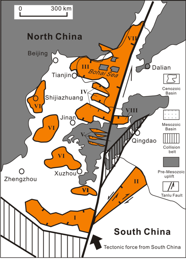
Figure 3. Distribution of the Mesozoic basins in the North China
Ⅰ-Xinyang-Hefei Basin; Ⅱ-Subei Basin; Ⅲ-Bohai Basin; Ⅳ-Jiyang Basin; Ⅴ-Luxi Grabens; Ⅵ-Xu-Shi Basin; Ⅶ-Liaohe Graben; Ⅷ-Jiaoliao Graben
(sources: Shandong Geological Map, 1990; Hou et al., 2001; and new seismic sections from the offshore oilfield company, 2005)
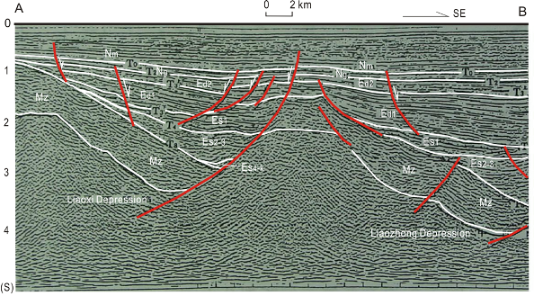
Figure 4. New seismic reflection section (AB) in the offshore of the North China Basin
Location of section AB is shown in Fig.2 and Fig.5. Mz-Mesozoic Formation; Es4-k-Eocene Shahejie Formation 4 and Kongdian Formation; Es2-3-Eocene Shahejie Formation 2 and 3; Es1-Eocene Shahejie Formation 1; Ed1-Oligene Dongying Formation 1; Ed2-Oligene Dongying Formation 2; Ng-Miocene Guantao Formation; Nm-Miocene Minghuazhen Formation.
(source: Bohai Oilfield Company, China)
Aside from the foreland basins in the south of the NC, the basins located within the craton are extensional in origin and are of Late Mesozoic age, all occurring in the east of the craton. Four Late Mesozoic NW trending basins were identified on the west of Tanlu Fault Zone, from north to south, the Bohai Basin (Ⅲ), Jiyang Grabens (Ⅳ), Luxi Grabens (Ⅴ) and Xu-Shi Basins (Ⅵ). Two late Mesozoic basins are identified on the east of the Tanlu Fault, one of which is the N-NE trending Liaohe Graben (Ⅶ) within the Tanlu Fault Zone. The other is the E-W trending Jiaolai Graben (Ⅷ) (Figure 3).
The Jiyang Grabens consists of three narrow grabens configured in an en echelon arrangement. The Luxi Grabens in the western Shandong Province consists of five narrow grabens in an en echelon arrangement. The Xu-Shi basins consist of four Late Mesozoic relic depressions from Xuzhou to Shijiazhuang in a northwest orientation, which were probably linked together to form one northwest trending basin before they were uplifted (Figure 3). The Late Mesozoic Tanlu Fault Zone is also a narrow rift, which consists of two grabens and an uplifted section (Xu, 1993). The northeast trending Subei basin developed on the east of the Tanlu Fault (Shang et al., 2002).
The Mesozoic parts of the Bohai Bay Basin formed during the Late Jurassic and Early Cretaceous by the deposition of sedimentary and volcanic units in an intra-plate rift environment. The Late Jurassic and Early Cretaceous volcanic rocks display NW orientations, controlled by NW-trending master faults on the west of Tanlu Fault Zone and NNE orientations within the Tanlu Fault Zone (Tian et al., 1992; Hou et al., 2003). These grabens were filled with Late Jurassic tuffaceous sandstones, brown mudstones and andesitic basalts that were deposited unconformably on pre-Mesozoic basement (pre-rift sediments) during the Late Jurassic. During the Early Cretaceous, the Qingshan Formation (Jq) was deposited in differentially subsiding grabens and half-grabens in the eastern NC, which consists of dark grey mudstones, grey-green muddy sandstones and brown-red sandy conglomerates interbeded with volcanics.
Yi and Hou (2002) proposed that master faults controlled the deposition of the Late Mesozoic sediments. These master faults are northwest trending, as revealed by highly sensitive seismic reflection sections and by the distribution of the Late Mesozoic sediments (Figure 3 and 4). They show syn-rift movement during the Late Mesozoic and are thus growth faults (Hou et al., 2001).
Seismic sections from the Bohai Bay Basin show that the depocenters of the Mesozoic basins are not coincident with the Cenozoic basin depocenters. The Mesozoic basins appear to have been of greater lateral extent than the Paleocene basins, but smaller than the Oligocene and Miocene basins. The uniform Mesozoic basin is fragmented by Cenozoic basins (Figure 4) and the Cenozoic depressions rest on the Mesozoic depressions, giving the Bohai Bay Basin the structure of a superimposed basin.
The orientations of these basins, master faults and volcanic rocks suggest that these Mesozoic basins were induced by sinistral strike-slip movement within the Tanlu Fault Zone. The northwest trending Late Mesozoic basins have a structural orientation that is distinct from the northeast and east-west trending Cenozoic basins in the eastern NC. The differences between Mesozoic and Cenozoic basins result from their development in different tectonic settings related to the different strike-slip movements within the Tanlu Fault Zone (Figure 2 and 3).
The Early Mesozoic collision between the NC and the SC caused intra-continental deformation (Zhao and Zheng, 2005; Yin and Nie, 1996). The pre-Mesozoic structural trends in the basement of the NC are dominantly east-west (Qian, 1986; Gong, 1987; Wang et al., 2005). There is evidence for further convergence between two blocks accommodated by thrusting in the Dabie and Sulu Orogens during the Early Mesozoic (Okay and Sengör, 1992). The NC developed an orogenic belt along the southern margin of the craton, and intra-continental deformation shaped the Eastern North China Plateau by thickening of the lithosphere. The Tanlu Fault Zone accommodated sinistral strike-slip, and acted as a transfer zone between the thrust-dominated orogenic zones (Xu, 1993; Xu et al., 1993; Ross et al., 1996). The Late Mesozoic grabens on the two flanks of the Tanlu Fault Zone suggest that these grabens have their origins in a transtensional fault zone. The right-handed pattern of the en echelon grabens resulted from sinistral strike-slip within the fault zone and thus they developed under the same tectonic stress field (Figure 3). The Late Mesozoic extension and rifting of the eastern NC signalled the onset of the destruction of the NC. Mesozoic rifting stopped in the Late Cretaceous, allowing initiation of temperary uplift. The Bohai Bay Basin has experienced a newer phase of extension and rifting since the Paleocene.