Geologic Setting
The Tres Arboles and Los Tuneles fault zones collectively extend for more than 250km along the western margin of the Sierras de Córdoba (Simpson et al., 2003; Whitmeyer and Simpson, 2003; Figure 1). These faults likely facilitated the Paleozoic juxtaposition of the two principal components of the Eastern Sierras Pampeanas: The Sierras de Córdoba terrane in the east and the Sierra de San Luis terrane in the west (Whitmeyer and Simpson, 2003; 2004). The Early-Middle Paleozoic was a period of protracted convergence along the western margin of Gondwana (Ramos, 1988), and the assembly of the Eastern Sierras Pampeanas is likely coeval with one or more significant tectonic events that affected Gondwana, such as the Famatinian (Aceñolaza and Toselli, 1988), and Achalian (Sims et al., 1998) orogenies.
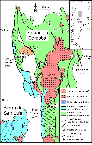
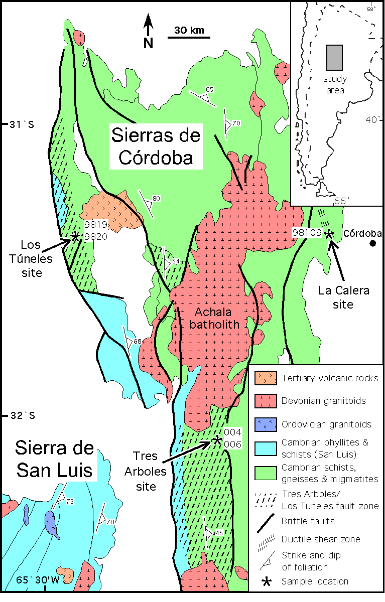
Figure 1. Simplified geologic map
Simplified geologic map of the Sierras de Córdoba and northeastern portion of the Sierra de San Luis, Argentina. Los Tuneles, La Calera and Tres Arboles sample locations indicated by arrows.
Cenozoic uplift and exhumation of the Sierras de Córdoba have exposed crustal depths of 10-12km along the Los Tuneles fault zone in the northwest (Simpson et al., 2003), and 18-22km along the Tres Arboles fault zone in the southwest (Whitmeyer and Simpson, 2003). The Los Tuneles fault zone thrusts biotite+garnet+sillimanite schists to the west over biotite+chlorite phyllites (Simpson et al., 2003). Greenschist-facies S/C mylonites predominate within a several-hundred-meter-thick shear zone and are overprinted by cataclastic fabrics directly above the thrust contact. Within this region cm-thick pseudotachylyte veins intrude both parallel and at a high angle to mylonitic fabrics and host-rock foliation (Figure 2a). The Tres Arboles fault zone consists of a 16km-thick zone of mylonites and abundant ultramylonites that juxtapose high-grade gneisses and migmatites of the southern Sierras de Córdoba against biotite quartzites of San Luis affinity (Whitmeyer and Simpson, 2003; Figure 1).
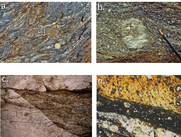
Figure 2. Los Tuneles fault zone
(a) Outcrop photo of Los Tuneles fault zone, showing pseudotachylyte vein cross-cutting greenschist-facies S/C mylonite. (b) Outcrop photo of sigma feldspar grain in Tres Arboles fault zone mylonites. (c) Outcrop photo of Achala-related granite truncating Tres Arboles fault zone ultramylonites. (d) Photomicrograph of dark brown pseudotachylyte vein (analyzed) intruding light brown pseudotachylyte + cataclasite, La Calera fault zone; representative 300 µm raster square indicated in pseudotachylyte vein. Plane light. Coin for scale in (a), (c) = 2.5 cm; pencil length in (b) = 4 cm.
The La Calera fault zone extends for several kilometers along the northeastern margin of the Sierras de Córdoba (Figure 1), and includes several discrete, meters-thick zones of amphibolite-facies mylonitic and ultramylonitic rocks (Simpson et al., 2003). Greenschist-facies S/C fabrics overprint higher-grade ultramylonites and contain local, cm-thick pseudotachylyte veins that are mostly subparallel to the mylonitic fabric (Figure 2b). Northrup et al. (1998) reported a 40Ar/39Ar age of 428±12 Ma from pseudotachylyte in this zone.