Introduction
This paper results from questions provoked by geologists involved with the Mount Isa deposits and discussions pursued over the last year, particularly on observation of rock exposures and drill core. The most debated issue remains the timing relationship between the lead-zinc and copper deposits at Mount Isa itself. Also addressed are questions raised by Painter et al. (1999), particularly with respect to the timing of fine-grained pyrite formation. As this paper was being revised following reviewers' comments, another paper (Davis, 2004) was published. It adds considerable data on geometry and metal distribution on the lead-zinc orebodies and concludes that the lead-zinc orebodies were structurally controlled during D4 which corresponds with D3 of this paper. It is not discussed further here.
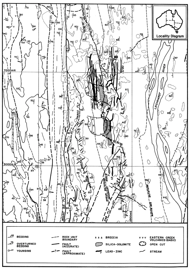
The questions are ordered with respect to those which relate to the orebody environment, the copper orebodies and the lead-zinc orebodies. An overview of the mine area is shown in Figure 1, which illustrates the relative positions of the lead-zinc and copper orebodies (highlighting those referred to in the text) and their relationship to the Paroo-Basement fault.
Figure 1. Surface map of the mine area.
Surface map of the mine area showing the main geological features and the relationship of the ore environment to the major structures. Only the basic volcanic sequences of the Eastern Creek Volcanics have been highlighted (rock symbol v). East of the Paroo Fault are formations of the Mount Isa Group. Lead-zinc orebodies (with identifying numbers) in the Urquhart Shale have been projected from the closest data in unweathered rock to show an estimate of original ore at the current erosion level. Orebodies 7 and 8 mentioned in the text have been shown in bolder numerals. Silica-dolomite is from the 1966 surface mapping by W.D Smith (pers. comm. 1994), updated by more recent drilling (S. de Kruijff, pers. comm., 1983). The unconformity west of the Mount Isa fault was mapped by J.M. Proffett in 1989 (Proffett, 1990). Modified from 1:2500 map compiled by P. Stoker, 1991. Outcrop boundaries are not shown west of the Mount Isa Fault, which is generally an area of good exposures. Inset. Location of Mount Isa.