Introduction
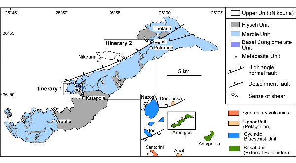
The island of Amorgos is located approximately 35 km east of Naxos in the central Aegean Sea (Figure 1). It separates the Cycladic Blueschist Unit (Dürr et al., 1978; Bonneau, 1984) from rocks of the Lycian Nappes farther east (De Graciansky, 1972; Bernoulli et al., 1974), and can therefore provide important information on the regional correlations of orogenic components (Jolivet et al., 2004).
The geology of Amorgos has been mapped by Dürr (1985) and was the topic of relatively few published articles (Renz, 1933; Tataris, 1965; Dürr et al., 1978; Minoux et al., 1980; Fytrolakis et al., 1981). Most of these studies concentrated on lithological aspects, mostly suggesting that the stratigraphy of Amorgos resembles the stratigraphy of the Tripoliza zone of the external Hellenides. In addition, there are a number of studies dealing with the neotectonics of Amorgos (Papadopoulos and Pavlides, 1992; Stiros et al., 1994; Perissoratis and Papadopoulos, 1999), particularly because of the destructive 1956 MS = 7.4 earthquake, which occurred southeast of Amorgos and generated a tsunami with waves reaching a height of 20-30 m in the southern coast of the island.
The structure and metamorphism of Amorgos have so far received relatively little attention (Theye et al., 1997). Some new information has been provided in our recent study (Rosenbaum et al., 2007), but there are still many open questions and uncertainties.
In this field excursion we provide a general introduction to the structure and metamorphism of Amorgos. The excursion can be done in 2 days
Figure 1. Amorgos
Simplified geological map of Amorgos (modified after Dürr, 1985) showing the locations of the two itineraries.