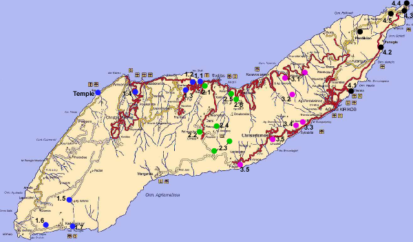
The map shown in (Figure 21) shows the main road on Ikaria and also the field trip stops.
Kampos, the old capital of Ikaria is a good place to start a field trip. Leave the ferry from Piraeus in Evdilos and drive about 5 km to the west. Stay at Dionysos Rooms (http://www.island-ikaria.com/hotels/dionysos.asp), Vassilis, the owner, is a very nice and entertaining bloke who is used to weird geologists. He is also the curator of the archaeological museum (Stop #1.1). Stroll down to the beach in phyllite of the Messaria nappe and find ductile to brittle-ductile top-NNE shear bands in the road cut on the left hand side as you walk down to the beach.
The I-type Raches granite is generally believed to be ~22 Ma old. This inference is based on a Rb/Sr whole-rock errorchron published by Altherr et al. (1982). Faure et al. (1991) and Kumerics et al. (2005) showed that the granite is synkinematic to top-NNE extensional shearing and mylonite dating and rapid footwall cooling indicate that extensional shearing did not start before ~12-11 Ma. Our dating of magmatic zircons form the I-type Raches granite and the smaller S-type Karkinagrion and Xylosirtis granites yielded intrusion ages of ~14-13 Ma (see above).
Stop #1.1: Archaeological Museum in Kampos
Situated on a hill, which was the ancient citadel of Oenoe, the first capital of Ikaria, the Kampos Archeological Museum contains over 250 finds from Ikaria. Museum items include Neolithic tools, pottery vessels, clay statuettes, columns, coins, and carved headstones. The museum is located within a courtyard that also contains the Church of St. Irene, built on the site of an ancient temple to Dionysus. Usually open three times per week from 10:00am to 3:00pm, but Vassilis would open it for you almost any time.
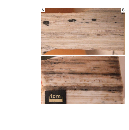
Stop #1.2: Extensional structures in phyllite of Messaria nappe
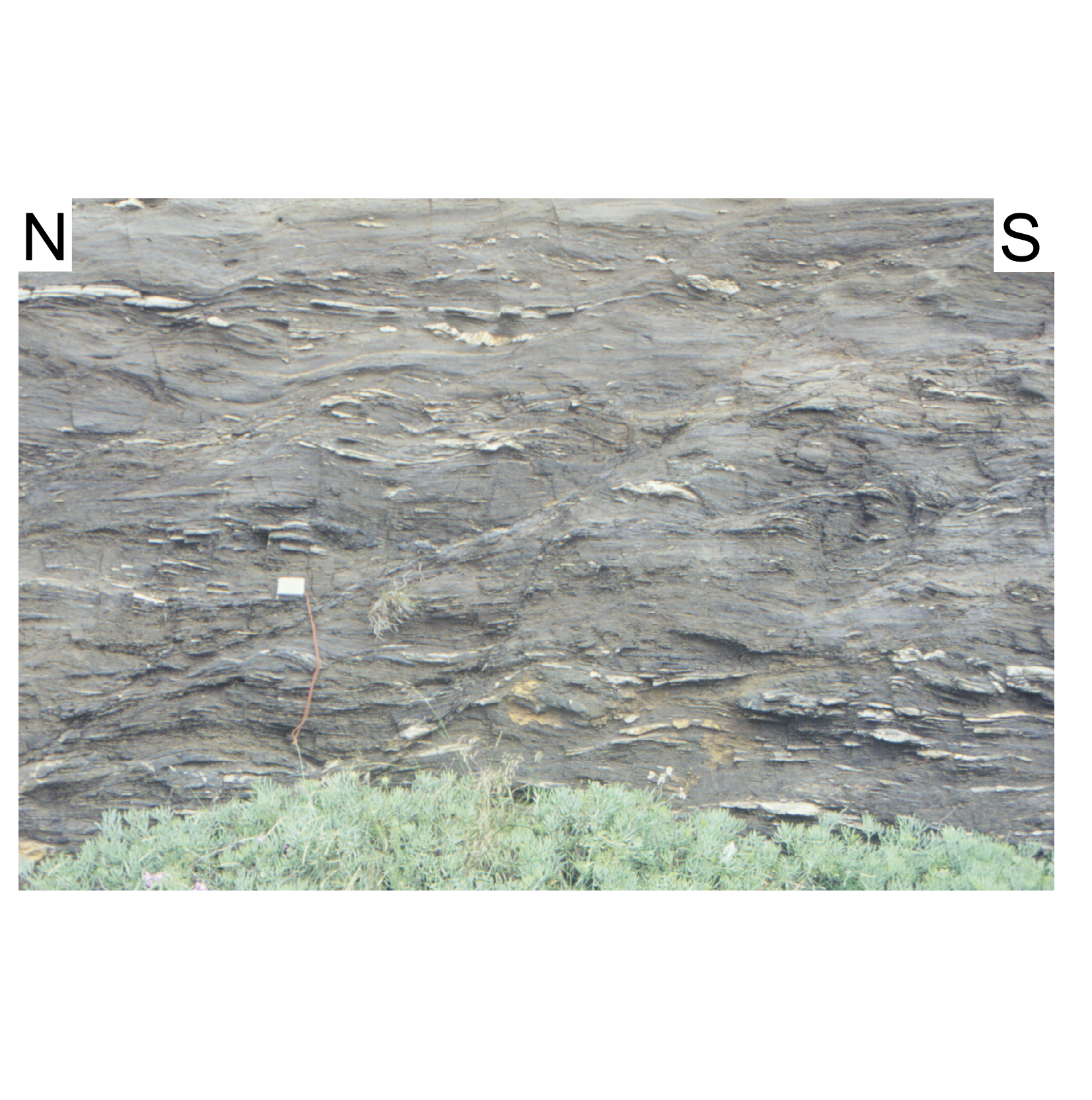
Drive from Kampos towards Armenistis, about where the last houses of Kampos are close to the turnoff to Fratato there are greyish to black phyllites exposed in the roadcuts with nice brittle to brittle-ductile shear bands and normal faults indicating top-NNE shear (Figure 22).
Figure 22. top-N shear bands
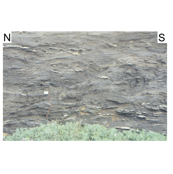
Photograph showing various sets of top-N shear bands in metapelite of the Messaria nappe. The shear bands in the upper part of the photograph have a low-angle geometry. The shear bands in the lower half of the photographs have steeper angles and are distinctly more brittle-ductile in nature and grade into normal faultss.
Stop #1.3: Road to Fratato; folded granite and phyllite sequence
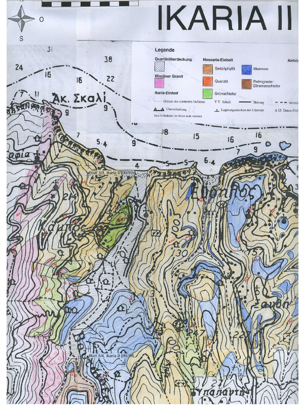
Drive uphill on the road to Fratato. To the west you see outcropping Raches granite and to the east below the road are rocks of the Messaria nappe. Granite occurs as dikes and lenses in phyllite of the Messaria nappe and both rocks are tight to isoclinally folded. Mapping at the 1:10,000 scale in 1999 by 3rd and 4th year students suggests that this granite is the I-type Raches granite (Figure 23). Regional structural analysis shows that folding and stretching of the granite and its country rock is related to top-NNE extensional shearing. This in turn shows that the Raches granite is also deformed together with the hangingwall plate of the Messaria extensional fault system. We have found no field evidence for intrusion of the I-type Raches granite into the rocks of the Messaria nappe. In line with Lister & Davis (1989) we envisage that large relative displacement along the Messaria detachment caused locally complex excisement geometries when the detachments cut into the upper plate thereby juxtaposing lower and upper plate rocks causing them to deform together. The Fanari detachment can be envisaged as a late excisement splay that cut into the upper plate allowing the active detachment to rise through the section.
Figure 23. Messaria nappe S of Evdilos

Geologic map at 1:10,000 scale of the Messaria nappe S of Evdilos. The Raches granite in the W is shown by the pink colour; the granite is folded with the sericite phyllite (shown in light brown) and also occurs as lenses in the Messaria nappe. Also shown is the relatively large greenschist body in Kampos.
Turn round and go back to the Evdilos-Armenistis road and drive to Armenistis. Most of the drive is in variably deformed Raches granite. Near Armenistis there are two nice sandy beaches. Usually beaches in the Cyclades are rather rocky but granite weathering gave rise to these fairly rare sandy beaches.
Stop #1.4: Ultramylonitic granite S of Armenistis
Just when you come into Armenistis there is a turnoff to the S (left up the hill) to Christos Raches. The road climbs up in hairpin turns and after about 1-1.5 km there is a sharp right-hand turn followed by a left-hand one. After the latter there are extremely deformed granites exposed in the roadcut to your left. The rock is very weathered but the very fine grain size and the ultramylonitic deformation of the granite is ubiquitous (Figure 24). Except the extremely narrowly spaced foliation and numerous late joints there are hardly any structures visible. However, occasionally you will find very nice small-scale shear bands (a hand lense comes in handy for this exercise). The Messaria shear zone dips at about 10-20º to the N and it is likely that the outcrops are very close to the detachment above your heads.

Head towards Christos Raches and then try to find the right road to the dams and Agios Isodoros by bearing right in Christos Raches. (The pedestrian area in the village is worth a wander.)
Stop #1.5: Deformed Raches granite near Agios Isodoros
After passing the dams the dirt road heads to the SW and is more or less flat. At the turnoff bear left and the road slightly climbs up to a ridge in front of you. On the ridge, the deformed granite in the Messaria shear zone dips almost horizontally. You reached the main crest of the island and here the shear zone has a subhorizontal attitude (Figure 7). The granite has a well-developed foliation and NNE-trending stretching lineation and kinematic indicators indicate a top-NNE shear sense.
A bit down the hill is the monastery of Agios Isodoros. Have a look down to the south: to the right (west) you see more whitish I-type granite. To the left (southeast), the outcrops have a more yellowish-brownish colour suggesting a difference in granite composition (see stop #1.7).
Drive back down to the turnoff and then take a left. The road goes in Raches granite and winds down to west where it eventually hits the road from Armenistis to Karkinagrion. Take another left at the turnoff; the road to Karkinagrion all of a sudden turns into a wide asphalt road.
Stop #1.6: Raches granite west of Karkinagrion
When the road descends in wide bends east towards Karkinagrion the Raches granite is hardly deformed at all and exhibits typical granite textures. There are some rather large potassium feldspar minerals in a quartz-plagioclase matrix; biotite is usually abundant. Sphene, red allanite, apatite, titanomagnetite, zircon and tourmaline occur as accessory phases. It is from this area were sample IK7 was collected.
Stop #1.7: Relationships between the Raches and Karkinagrion granites east of Karkinagrion
Drive through Karkinagrion to the east. On the western side of a N-S running creek the I-type Raches granite is exposed, whereas on the eastern side of the creek a yellowish to brownish two-mica granite with abundant white mica is exposed and we refer to this granite as the S-type Karkinagrion granite. Both granites exhibit magmatic textures and hardly any signs of tectonic deformation. The Karkinagrion granite contains occasionally garnet and also tourmaline. There is a faint steeply-dipping N-S-striking foliation visible in the Karkinagrion granite. In a few places fabrics suggest that the S-type Karkinagrion granite intruded the I-type Raches granite. However, as shown above the intrusion ages for both granites overlap within 2σ error. Sample IK-05/7 was collected in this area. There are also late-stage garnet- and tourmaline-bearing aplite dikes that crosscut both granites.
You could go back to Kampos along the north coast and visit the temple of the Ikarian Artemis in Nas. The road is winding and not in good conditions but the scenery and the temple is worth to take the coastal road. The drive is in variably deformed Raches granite, which in part shows spectacular shear bands (Figure 25).
During the 6th century BC the Ikarians built a temple in Nas to honour the mother goddess Artemis, patroness of sailors and protector of hunters and wild animals. Nas was probably the first settled area of Ikaria and throughout antiquity its safe anchorage was an important staging point on the sailing route from Asia Minor to Delos, especially during the months of October and November, season of the Apatouria in ancient times, when, due to the strong southeastern winds, voyagers to Delos preferred to sail along the north coast of Ikaria, where they would get supplies and shelter from bad weather. Nas never developed into a town in the ancient meaning of the term. The people who lived here lived on the goods the sea gave them, on bird and deer hunting and bred their own animals. Nas is known for the temple of Tavropolos Artemis (tavropolos means ‘herd of bulls’). The temple of Tavropolio must have been a late Minoan structure as the goddess was worshipped in the late Minoan period. Ikaria was one of the first stops of Artemis from Asia Minor and Tavropolio a shrine celebrated throughout Greece. Tavropolio prospered in the years when worship of the goddess was at its peak in the era of Attic civilization. According to the historian Ioannis Melas, Tavropolio was probably not only the temple of the goddess Artemis but also a settlement, one of the four ancient settlements on Ikaria, but no evidence has come to light to prove it. It is also very possible that there is a relationship between the temple of Nas and the other temples of Artemis that existed in that section of the Aegean Sea – Samos, Fokea, Chios, Patmos, Delos and Efessos. Around 1830 local Ikarian villagers melted down most of the temple's stone blocks in order to build a church. Legend has it that the ancient temple's statue of Artemis is buried somewhere in the river. Snorkeling just off the coast one can see the massive columns of the temple. The pier of the ancient port and the floor of the sanctuary still survive. A few kilometres away from Nas is Cape Kavo Papas. ‘Papa’ was one of the older names of the god Attis, the manifestation of Mother God (whom the Greeks would later identify as the goddess Artemis).
In 1938 the famous Greek archaeologist Leon Politis came to Ikaria to take over the first archaeological excavation of Nas. Although well known, the temple was not a large building. Politis started his search 25 m west of the river, near the lime kiln of the 19th century and realised that the dimensions of the temple were 9.70 x 3.75 m. It was founded on an enhanced basis, which was necessary on this unstable, sloping ground. The second building, 10 m to the south, was smaller (3.10 x 2.15 m) and probably sheltered the famous wooden statue of the goddess. Among other objects, he found an elaborated wine cup from Rhodes, showing a chamois, a buckle with a lion head, a beautiful statue head of the Hellenistic years, as well as two bodies from women’s statues, one of them from the 5th century and the other from the 2nd century BC. Politis also revealed some fulcrums of ionic and doric columns and saw pieces of columns in the sea.
Stop 2.1: Greenschist
Take a left towards Evdilos at the main road and go downhill for about 400m. On your left-hand side there is deformed greenschist of the Messaria nappe exposed. The greenschist exhibits the typical subhorizontal extension-related foliation and a well-expressed NNE-plunging stretching lineation. Have a good look around and find kinematic indicators which will give a top-NNE shear sense.
A bit further down the road are ruins of a 1st century AD Byzantine odeon (Figure 26), which served as a central meeting place and forum for musical and theatrical events for the people of the ancient Ikarian capital Oenoe. Oenoe was a prosperous city known throughout the ancient world for its viticulture.

Stop 2.2: Domino-style tilting in upper plate
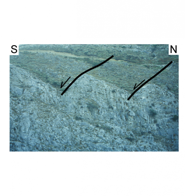
Take the turnoff to Dafni in Evdilos and drive for about 5-6 km uphill to the south. You go through phyllite and marble of the Messaria nappe. South of Dafni the road drops down a bit into a N-S oriented gorge and in the cliff on the right-hand side some metre-scale tilted marble blocks can be seen (Figure 27). The blocks are back-tilted to the S and are separated from each other by N-dipping small-scale faults.
Stop 2.3: Base of Messaria nappe
Drive on to the south and climb up on the road to the crest of the island. There you will find a little church on the left-hand side of the road in a thick marble sequence. From the church or the hill just above it you have a good view down to the north overlooking the rugged morphology of the Messaria plain (basically made up by phyllite and marble of the Messaria nappe). The topography to the east in the monotonous metapelite of the Ikaria nappe is quite different, as is the topography in the granite to the west. Our interpretation is that the upper plate of the Messaria extensional fault system, the Messaria nappe in the central part of Ikaria, is cut by a number of brittle faults and only a few of them also affect the lower-plate rocks. Also note that to the north the slopes dip rather shallowly to the N, whereas to the S the slopes are steep giving the island its overall asymmetric architecture.
The road drops down to the south and makes a turn to the east. You see the base of the marble, which is the base of the Messaria nappe, exposed in the road cut. The contact is not spectacular. The marble is strongly brecciated (Figure 28) and the underlying metapelite shows brittle-ductile deformation and late upright folding.
Figure 28. Brecciated base of Messaria nappe
Brecciated base of Messaria nappe at road from Evdilos to the south coast. Composite photograph on top shows road section; photograph on left show pronounced brecciation of marble; photograph on right depicts upright folding of metapelite below the brecciated marble.
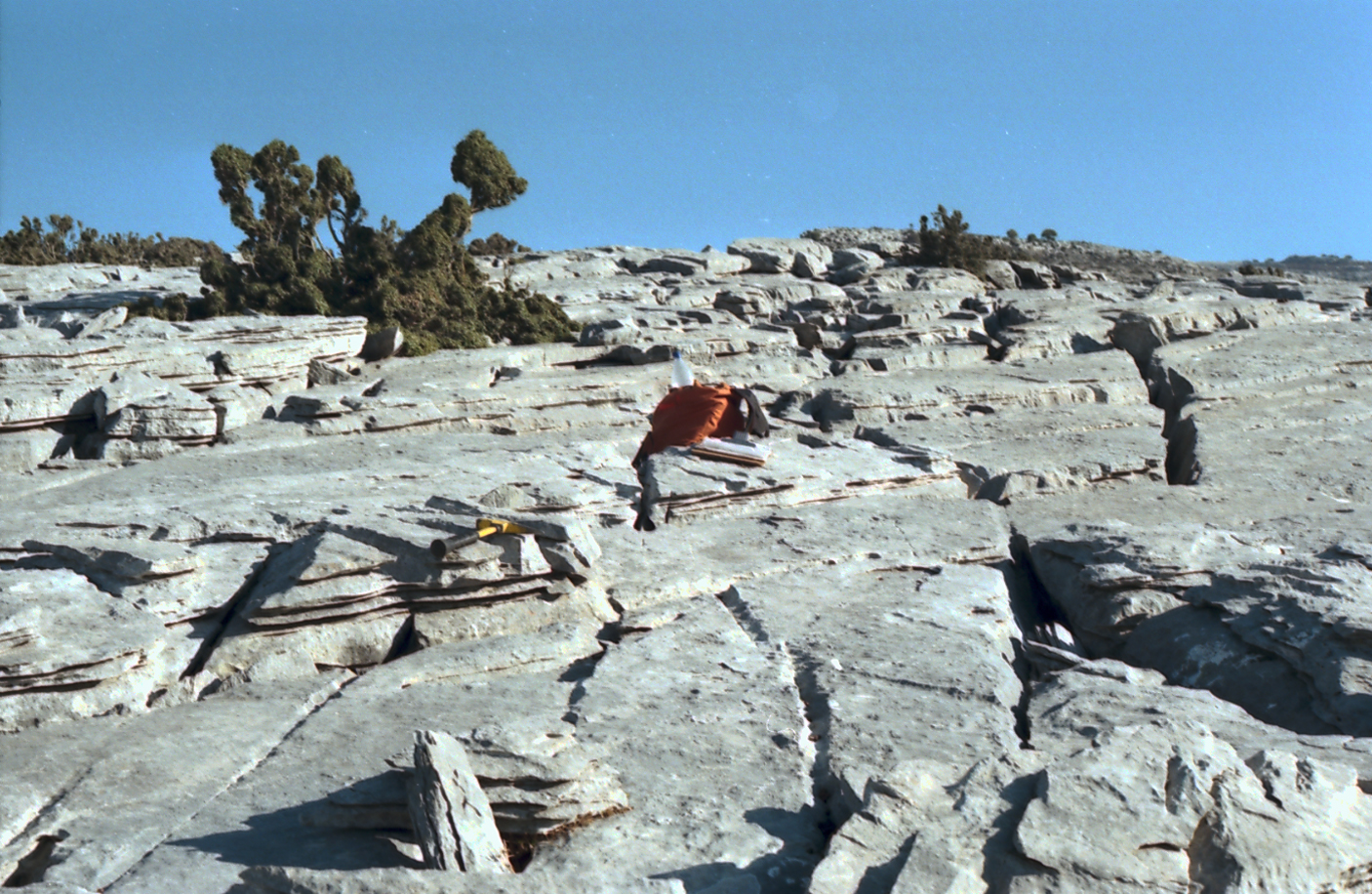
Mylonite sample IK99XD described above was collected ~1-2 km ENE from the church at the pass. Walk along the crest line (Figure 29) across marble with abundant karst features (Figure 30) and you will find occasional patches of rather whitish and strongly deformed quartzite below the marble. This quartzite forms lenses at the boundary between the Messaria and Ikaria nappes. This boundary is commonly decorated by brownish, in part dolomitic marble (Figure 31). Towards the ENE the crest line slightly climbs up and WSW of the highest knoll (909 m.a.s.l.) you will find whitish quartzite below whitish marble. The marble tends to become impure towards its base and contains white mica and other minerals. In quartzite sample IK99-31 chloritoid is in equilibrium with kyanite, andalusite and chlorite. Kyanite also occurs as inclusions in chloritoid. The sample is characterised by the lack of biotite. The occurrence of kyanite and andalusite in equilibrium in IK99-31 from the Ikaria shear zone constrains pressures at 3-4 kbar. The presence of chloritoid with chlorite-aluminosilicate and the lack of biotite suggest temperatures of 350-400°C (Figure 32c, d). Our interpretation is that the P-T data reflect the physical conditions during mylonitisation in the Messaria shear zone and indicate a thermal field gradient of 25-35°C km-1 during movement in the Messaria shear zone. The intrusion of the synkinematic granites are in line with an elevated geotherm.
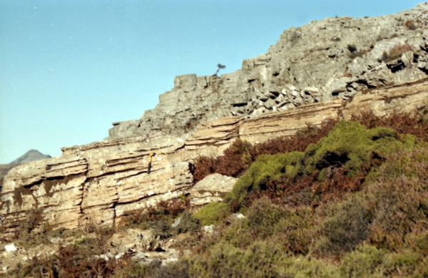
Figure 29. Steep marble cliff
Steep marble cliff. Base of the cliff marks the boundary between Messaria and Ikaria nappe.
Figure 30. Foliation planes in Messaria marble
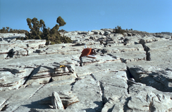
Foliation planes in Messaria marble showing abundant karst features. The karst developed along joint surfaces.
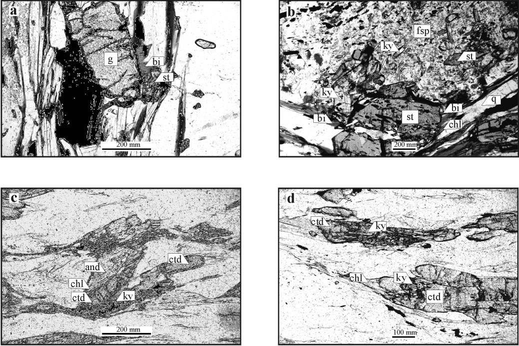
Figure 32. Microphotographs of samples

Microphotographs of samples from the Ikaria nappe and the Messaria shear zone. (a) Staurolite, chlorite and muscovite in equilibrium with biotite and garnet, sample IK02-6a. (b) Sample IK02-16 showing chlorite-staurolite-biotite-kyanite paragenesis; staurolite is in equilibrium with plagioclase and biotite, or occurs as an inclusion in plagioclase; kyanite occurs as an inclusion in plagioclase, or in equilibrium with staurolite, plagioclase and biotite; chlorite is in equilibrium with biotite and staurolite in matrix. (c) Chloritoid in equilibrium with kyanite, chlorite and andalusite in sample IK99-31. (d) Kyanite inclusions in chloritoid; sample IK99-31.
Stop 2.4: Koskina Castle and marble of the Kefala klippe
Drive back towards Evdilos and after ~2 km an unpaved road branches off from the main road to the southeast. Follow that road until the very end, from there here is a footpath to the Castle of Koskina, which is an 11th century A.D. Byzantine fortress located on a mountain peak overlooking the village of Koskina in the center of Ikaria (Figure 33). The Ikarians built the fortress because the Byzantine empire cut back its naval defense and the Aegean became open to inroads from pirates and Italian adventures. Some pirates fleeing Patmos arrived in Ikaria and where executed by the local population. Inside the castle is the church of St. George Dorganas.
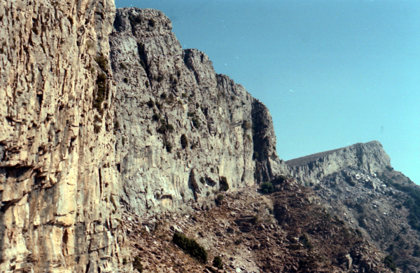
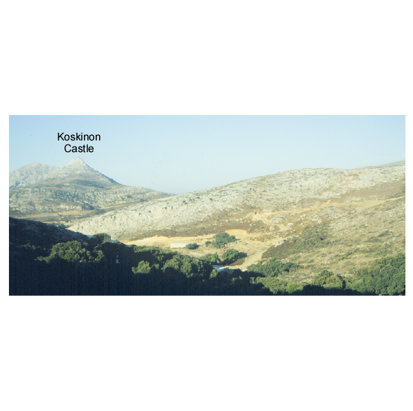
Figure 33. Messaria nappe and the Kefala klippe
Photograph showing the Messaria nappe and the Kefala klippe with the castle of Koskinon. Note the gentle dip to the N; view is to the E.
The fortress is built on marble of the Kefala klippe. There is a hornblende diorite dike exposed at the northern end of the klippe. The diorite is usually severely hydrothermally altered and pumpellyite, clinozoisite and sericite replaced magmatic plagioclase, and actinolite, chlorite, titanite and prehnite replaced brown hornblende. However, in rare cases fresh plagioclase and brown hornblende survived. Altherr et al. (1994) reported scattering K-Ar hornblende ages of 67 to 80 Ma from those diorites. One single amphibolite, which is intercalated within the marbles, also yielded a Late Cretaceous K-Ar hornblende age of 84 Ma. The host marble is supposed to be Late Triassic in age (Altherr et al. 1994).
Drive back to Evdilos and then turn right and follow the main coastal road to the east.
Stop 2.5: Extensional structures in upper Ikaria nappe
For the first ~2 km east of Evdilos you are still driving in phyllite with intercalated marble of the Messaria nappe. The contact to the underlying Ikaria nappe is generally poorly exposed and strongly overprinted by brittle faulting. About 800 m east of Evdilos in the first major bend in the road just S of the headland of Arethoussa, there a brownish-white marbles and phyllites which are heavily cataclasised. If you walk across the road and go down to the cliff you will be below the detachment and will find ductile top-NNE shear bands.
There are numerous outcrops in the roadcut on the right-hand side of the road of deformed quartz and pegmatite veins (Figure 14), (Figure 34). Most of the veins are parallel to the foliation and boudinaged. Some veins are at a small angle to the foliation and the boudins are asymmetric and supply a top-NNE sense of shear. Still other veins are almost perpendicular to the foliation and are folded. Christine Kumerics used these material markers for strain analysis and a quantitative assessment of the non-coaxiality of deformation (Kumerics et al. 2005).
Figure 34. Three examples of deformed pegmatite
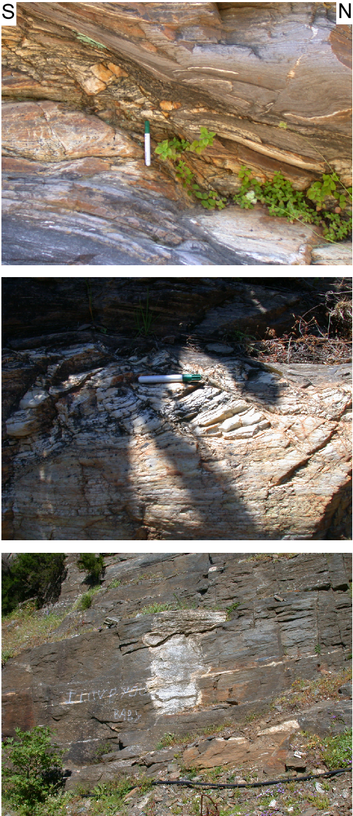
Three examples of deformed pegmatite. (top) Relatively thick foliation-parallel pegmatite layer in the middle of the photograph is stretched in the NNE direction and shows a number of Riedel shears just above cap of felt pen. The pegmatite below is boudinaged and asymmetry of boudinage also indicates top-NNE shear. Note that in the upper right-hand corner the small pegmatite vein is almost perpendicular to the foliation. (middle) Sheared pegmatite with large tourmaline crystals. (bottom) Wide pegmatite veins perpendicular to the foliation. Note that there is a subhorizontal, foliation-parallel pegmatite veins in the middle of the photograph.
Stop 2.6: Mylonitic pegmatite
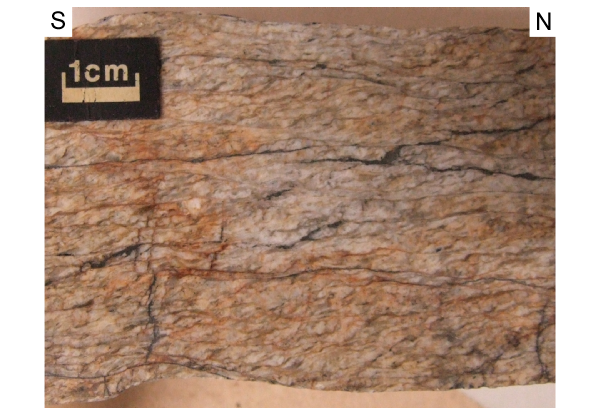
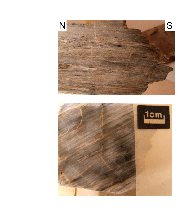
Drive further east until you reach a valley. Go down into the creek and walk up-stream. There are a number of pegmatites exposed in the creek. The mylonitic metapegmatite sample IK02-4 (Figure 35) is from an outcrop right in the creek bed. The pegmatite is a whitish-yellowish rock with up to 1-2 cm big tourmaline and white mica crystals. As summarised above, Rb/Sr analysis did not succeed in dating mylonitic deformation of this sample. Rather, the large white mica crystals on the mylonitic foliation planes yielded ages of up to 458±7 Ma, which are considered as a minimum age for protolith crystallisation. We believe that the large white mica crystals are actually about 550 Ma old and relate to a Pan-African magmatic event.
Figure 35. Mylonitically deformed pegmatite
(top) Photograph of mylonitically deformed pegmatite sample IK02. (bottom) Mylonitically deformed pegmatite from a locality directly adjacent to that of IK02.
The 40Ar/39Ar ages of IK02-4 range from 13.8±4.8 to 5.4±1.8 Ma and have a weighted mean age of 10.8±1.1 Ma (2σ errors). The ages from IK02-8 range from 11.1±0.3 to 9.5±0.5 Ma and show a weighted mean age of 10.5±2.4 Ma. We interpret the ages to date phengite recrystallisation during ductile deformation in the Messaria shear zone.
Drive from Kampos via Evdilos along the main road to the east. Numerous, variably oriented and deformed pegmatite dikes occur in metapelite of the Ikaria nappe in numerous roadcuts. Metapelite of the Ikaria nappe frequently contains garnet, kyanite and staurolite.
Before the road turns inland and climbs up, have a look back to the SW. There is a distinct difference in the morphology across the Messaria detachment: the marbles and phyllites of the Messaria nappe have a rugged morphology whereas the metapelite of the Ikaria nappe is much less dissected.
Stop 3.1: Kyanite-staurolite-biotite schist
A good outcrop containing kyanite and staurolite occurs on the right hand side of the road in a sharp bend just before Mileopori. In this outcrop, metapelite has the general paragenesis staurolite-biotite-plagioclase-kyanite-chlorite (Figure 32b). The rocks are distinctly foliated and stretched with the typical NNE trend of the extension lineation. Plagioclase often forms porphyroclasts and the penetrative foliation wraps around them. Staurolite and kyanite commonly grew in this foliation.
Plagioclase has andesine composition and shows a zonation from An43 (core) to An50 (rim). Kyanite occurs in plagioclase, and in textural equilibrium with staurolite, plagioclase and biotite in the matrix. Rare chlorite is in equilibrium with biotite and staurolite. The Mg content of chlorite is ~3 per formulae unit (based on 14-oxygen structural formula) and therefore we consider chlorite to be primary. Staurolite is widespread in the matrix, and also forms inclusions in plagioclase. The Si content in white mica varies from 3.10 to 3.15 (on the basis of 11-oxygen structural formula).
P-T estimates for IK02-16 are well constrained because the bulk-rock composition of this sample allows the paragenesis staurolite-biotite, but not the paragenesis garnet-biotite-staurolite. This implies a pressure <7 kbar (Figure 11b). Another indication for pressures <7 kbar is the chlorite-biotite-staurolite paragenesis, which is likely metastable in this sample (Figure 11b). The stable field for this paragenesis is near the staurolite-biotite trivariant field at pressures <7 kbar. Because kyanite is present, pressures are >6 kbar for a temperature of 600°C.
As stated already above, a very important conclusion is that there is no evidence for any high-pressure metamorphism pre-dating amphibolite-facies metamorphism in this and other samples from the Ikaria nappe.
A bit further up the road about 1 km W of Ploumarion you will find garnet-bearing schist in the road cuts. The main foliation wraps around the garnets and top-NNE shear bands occur. The development of the shear bands clearly postdates garnet growth.
Stop 3.2: Deformed Xylosirtis S-type granite on the crest of the island
Continue driving uphill to the east. When you almost reached the crest of the island there is a turnoff to the right. The dirt road brings you further up the mountains towards a transmitter station. Keep going towards the southwest along the crest of the hill. The road is usually pretty bad. If you worry about your vehicle, park it and walk. You will see the whitish S-type Xylosirtis granite when you look down to the south coast. The granite crops out along the main road at the south coast and also makes up a large part of the southern slopes of Ikaria's central part. About 100-200 m below the footpath along the crest of the island you will see the contact between the Xylosirtis granite and metapelite of the Ikaria nappe. There are a bunch of goat tracks that bring you to the contact zone. The latter is marked by mylonitically deformed granite and metapelite. Both rocks types are penetratively foliated and contain a pervasive NNE-trending stretching lineation.
Go back to the main road, take a right and drive down towards Agios Kirikos. A few kilometeres before you reach Agios Kirikos, bear right towards Xylosirtis and Chrisostomos.
Stop 3.3: Mildly deformed Xylosirtis granite
From the main road at the south coast you will see the whitish Xylosirtis granite in the mountainous slopes above the road. Almost everywhere along the road the granite is mildly deformed and hardly exhibits a tectonic foliation.
Stop 3.4: Garnet-staurolite schist
Continue along the main road towards Xylosirtis. When you get out of the granite proper you will find a contact zone in which metapelite of the Ikaria nappe and granite dikes are interleaved and both are quite strongly deformed together. There a clear intrusive relationships between the granite and the metapelite. Before you reach Xylosirtis there is a garnet-staurolite-bearing metapelite outcrop on the right hand side of the road in a creek bed. The rock shows big plagioclase and garnet crystals and occasionally top-NNE shear bands which wrap around the plagioclase and garnet.
Sample IK02-06a from this outcrop contains the mineral assemblage garnet, staurolite, biotite and rare epidote (+ muscovite + quartz) (Figure 32a). Garnet has a general grain size of about 3 mm and its composition is almandine (70-73%), pyrope (5-10%), spessartine (5-10%) and grossular (12-18%). Garnet has no major element zoning, mineral formulae do not show significant Fe3+ and therefore we assumed that Fe2+ = Fetotal. Staurolite occurs, together with chlorite, as inclusions in garnet or in the matrix in equilibrium with biotite and garnet. Epidote also forms inclusions in garnet or is common in the matrix in equilibrium with biotite. Chlorite only occurs as inclusions in garnet. The Si content of white mica in the matrix is 3.11-3.12 (on the basis of 11-oxygen structural formula).
T he pseudosection and AFM projections (Figure 11) constrain P-T estimates for IK02-06a at 6-8 kbar for a temperature of 600-650°C. Isopleths of phengitic substitution do not provide precise information on pressure but suggest that the maximum pressure was <8 kbar. The size of garnet (3 mm) does not allow any significant fractionation of the whole-rock composition. Because chlorite and staurolite occur as inclusions in garnet, the P-T path is probably clockwise (Figure 11a).
Stop 3.5: Marbles of Ikaria nappe
If you are keen to explore the south coast a bit further, continue going west towards Plagia. Before you reach Chrisostamos you will be in whitish-yellowish, coarse-crystalline, dolomitic marble of the Ikaria nappe. Locally this marble is referred to as the Nikaria marble. The marble is distinctly coarser grained the any marble of the Messaria nappe and also distinctly lighter in colour.
Go back to Agios Kirikos and spend the night there. Agios Kirikos is built on rocks of the Messaria nappe and intercalations of phyllite and marble dominate the hills around the town.
Take the road from Agios Kirikos towards the airport. This road to the airport used to be a very narrow road but was considerably improved and distinctly widened when we did field work on Ikaria. Road construction caused a number of new and fresh outcrops but may have meanwhile destroyed the outcrop described below.
Stop 4.2: Therma
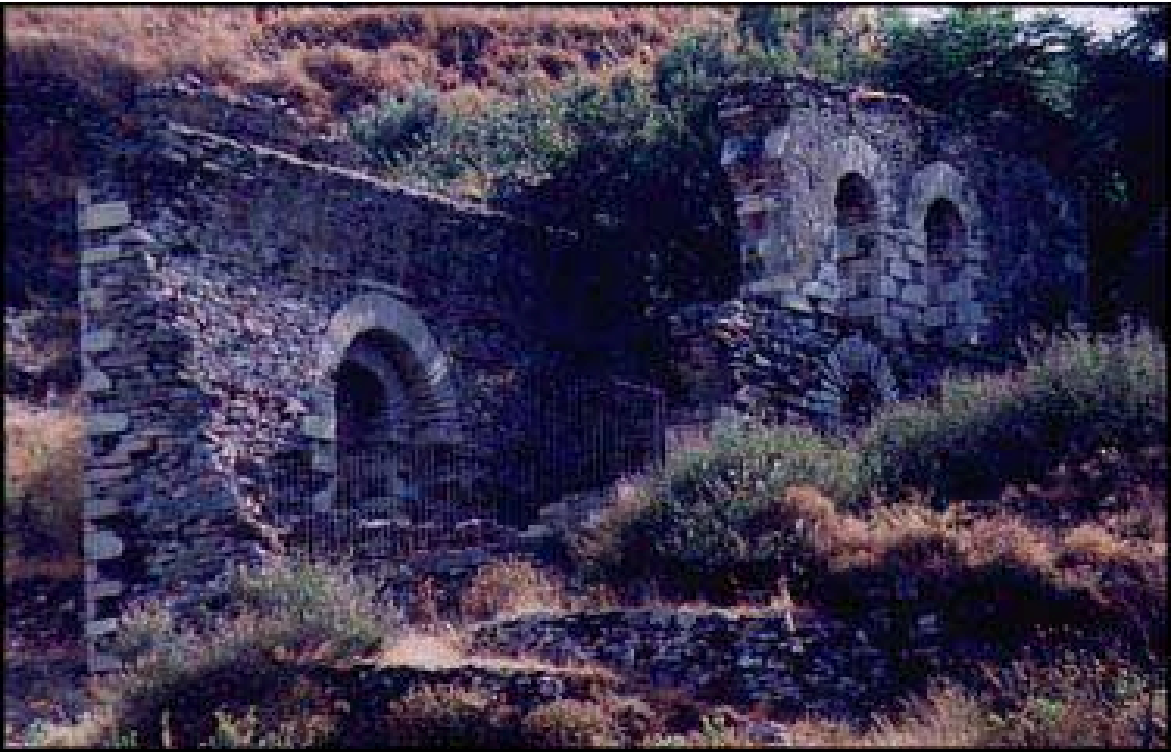
It is worthwhile to pay the town of Therma a visit. Since ancient times Therma is known for its therapeutic radon hot mineral springs. The hot springs aid in the curing of a multitude of afflictions such as rheumatism, arthritis, neuralgia, and infertility. The essential elements in Ikaria's therapeutic hot mineral springs are saline radium and radonium. It is the main spa town of Ikaria. The village feast is held on 1 July, the day of Agia Anargiri.
The name Therma is from the ancient Ikarian town of Thermae. In bygone days the inhabitants of Thermae were known as Asclipians from the god of medicine (Asclipios) and in recognition for their miracle working hot springs. At a small distance east of the present day town at the location "Xalasmena Therma" stand the ruins of the ancient spa. It was a seaside town built on a small projecting peninsula and was one of the known spas of ancient times. This is proven by the fragments of broken marble bath tubs found in the area and traces of an ancient aqueduct partly hollowed out in the rocks. Unfortunately it is not known exactly when this ancient town was inhabited. However, from a marble Stele found in the area we know that the town existed and flourished in the classical era and was a member of the Athenian Naval League. Its disappearance, probably due to an earthquake circa 205 B.C., did not allow for more information to come to the surface about the life of the Thermaen people. Although no archaeological research has been carried out it is believed that the seacoast where Xalasmena Thermae is situated is the exact location of the ancient city of Thermae.
Stop 4.2: Cataclasite at base of Fanari nappe
You drive in massive grey marble of the Messaria nappe and towards the airport this marble is becoming increasingly brittlely deformed. Because of the extensive roadworks the outcrop situation has changed considerably but you should be able to find extremely cataclastically reworked marble in the roadcuts around Panagia. The brittle deformation of the dark-grey marble of the Messaria nappe transformed the latter into a blackish, clay-bearing cataclastic rock. The cataclasite is foliated and contains numerous Riedel shears.
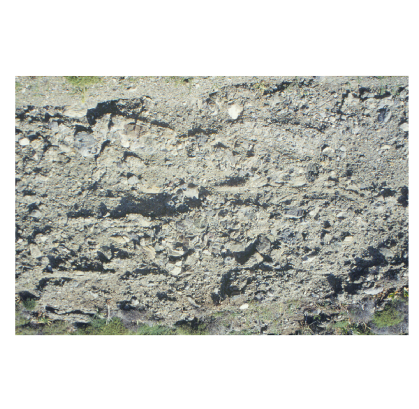
Stop 4.3: Conglomerate of Fanari nappe
Before you reach the airport there is a turnoff to your right towards Fanari. When you enter Fanari from the west, bear left and try to find a road that brings you to the eastern side of the valley, this is the road to the tower of Fanari. You will drive below the runway of Ikaria airport and then the road climbs slightly up to the south and southeast.
The Pliocene conglomerates of the Fanari nappe (Figure 28), which is part of the Upper unit of the Cycladic zone, contain pebbles of metamorphic rocks, which are not exposed on Ikaria Island. Abundant are amphibolite pebbles, marble is also ubiquitous. In addition a number of volcanic clasts occur, as do metapelite and quartzite pebbles.
Stop 4.4: Dracanum
Continue to the east on this dirt road until the road ends; from there it is a 10 min hike to the tower of Dracanum (Figure 2), which is a must-see on Ikaria. The tower is one of the best preserved Hellenistic military towers in the Aegean.
Turn around and go back via Fanari to the main road, take a right there, pass the main airport building and hit a dirt road that turns west after the airport. You are in grey marble of the Messaria nappe. This road brings you up to the crest of the island. After about 1 km WSW of the airport you will cross the contact between the Messaria and the Ikaria nappe. There are a number of good outcrops in the road cuts to your left. Go back up to the main road and then take a left down to Agios Kirikos.