In the following excursion guide, three traverses, covering each a full day, are described. All traverses start at Livádhi, the main port of Serifos, where all ferries dock and all tourist facilities including accommodations, shops and a bank are located. The Serifos touring and hiking map published by ANAVASI (http://www.anavasi.gr/en) at a scale of 1:20 000 is strongly recommended for its accuracy, GPS coordinates and richness in details. Chóra, the capital of Serifos, which is built on a hill that overlooks the bay of Livádhi can be reached by using either the municipal bus or walking the cobbled 2 kilometres mule path. However, for Traverse 1, cars are needed, which can be hired either at the port or at the filling station of Livádhi. Traverse 2 in the southeast part of Serifos can be reached by a short walk along the beach. Access to Traverse 3 is gained by the public bus from Livádhi to Meghálo Livádhi or by own cars. The GPS coordinates of the excursion stops are given in UTM (zone 35N, WGS 1984).
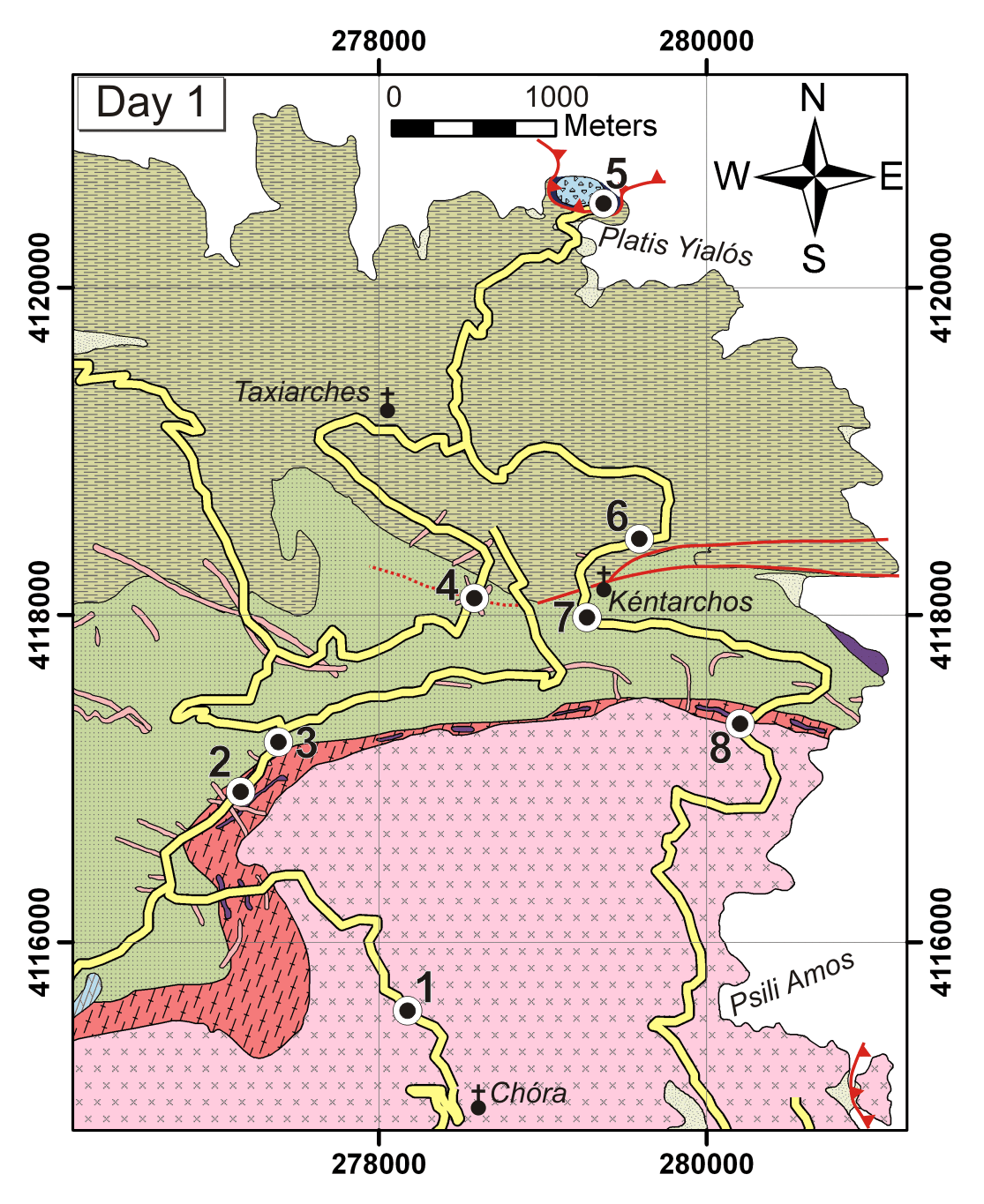
Traverse 1 introduces into the central and northern parts of Serifos focussing on the undeformed granodiorite, cross-cutting relationships between the intrusive contact of the main granodiorite pluton and its dykes, the mylonitic orthogneiss, amphibolite and the high-temperature skarns. Furthermore, lucid examples of brittle / ductile low-angle and cataclastic high-angle normal faults are incorporated. See Figure 3 for the location of excursion stops.
Figure 3. Traverse 1
Stops of Traverse 1 in the northeast part of Serifos. For the index of the geological map see Figure 2.
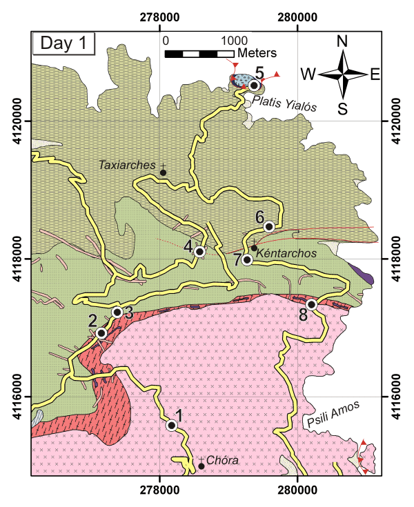
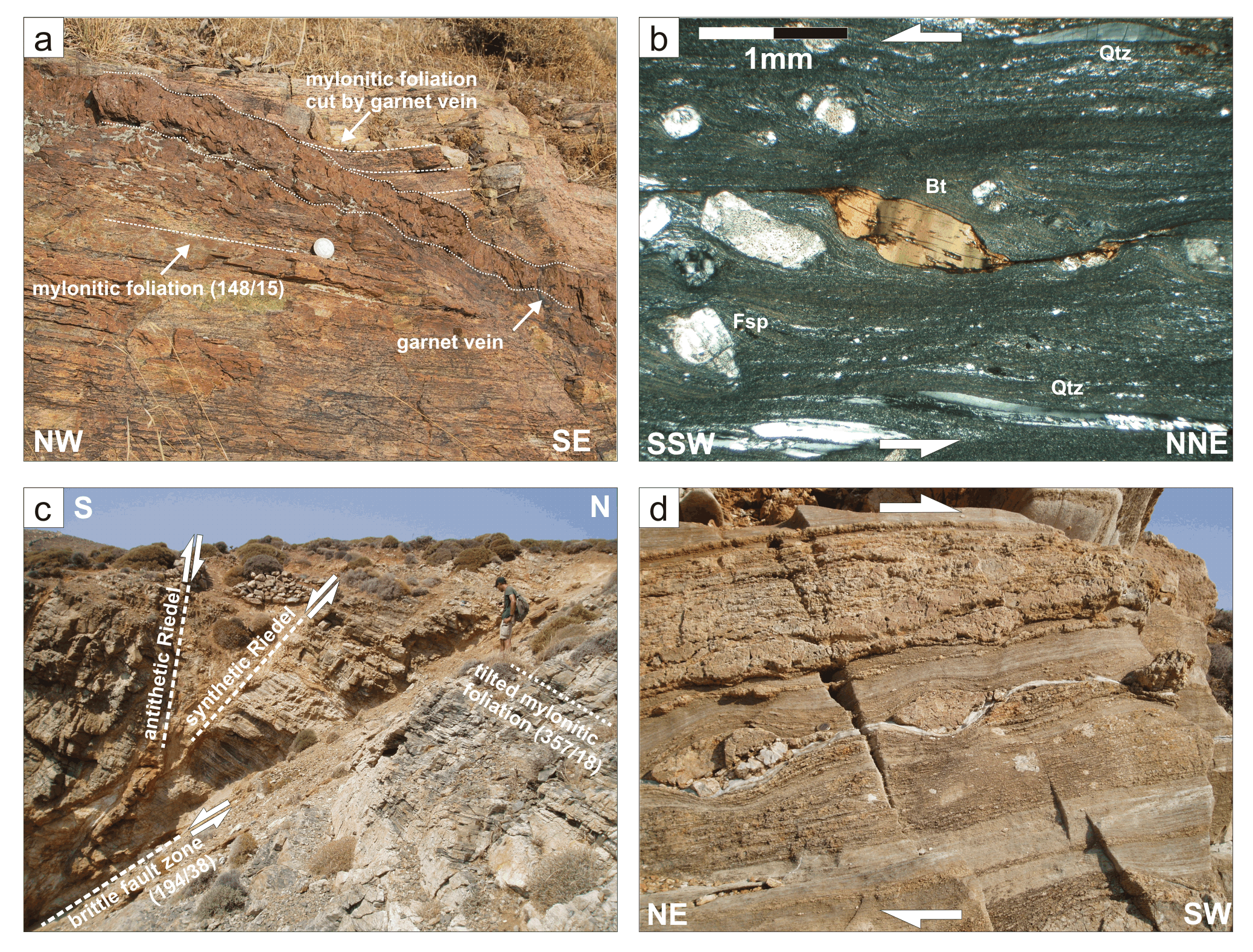
All along the main road N of Chóra (Χώρα), the undeformed I-type granodiorite of Late Miocene age (Altherr et al., 1982) is exposed. A conspicuous feature of the Serifos granodiorite is its subvolcanic-like microstructure consisting of subidiomorphic phenocrysts of K-feldspar, plagioclase, hornblende and biotite distributed in a matrix composed of smaller xenomorphic crystals of both feldspars and quartz. In this respect, fine-grained types of the granodiorite are indistinguishable from dacitic dykes that cross-cut the whole island. This observation indicates a high crustal level of intrusion. Along its northern margin, the granodiorite itself, as well as numerous associated dykes, cross-cut and therefore post-date the major metamorphic structures and the foliation of the rocks. Typically, the granodiorite body is strongly fractured by a several centimetre to decimetre spaced joint system along which fluids have bleached the rocks in a zone of up to several centimetres width (Figure 4a). Several generations of mode-I cracks and joints are filled with metasomatically formed minerals, including epidote, chlorite and carbonates.
Road cuts between stops 2 and 3 provide outcrops showing mylonitic orthogneisses, which are intensely deformed with amphibolites with gneissic intercalations. These rocks are the host rocks to the main granodiorite intrusion. The orthogneisses contain numerous magmatic relicts like perthitic K-feldspar and sharply zoned and twinned plagioclase. Additionally tourmaline, quartz, biotite and muscovite forming mica-fish are observed in thin-sections. Dynamic recrystallization of feldspar and the formation of striped gneisses suggest that mylonitic deformation occurred at high-grade metamorphic conditions. The foliation dips at moderate angles towards NNW and records a clear stretching lineation dipping towards NNE. Abundant micro- and macroscopic kinematic indicators point to SSW-directed shear. The orthogneisses contain veins with high-temperature skarn minerals (clinopyroxene + garnet +/- magnetite) that cross-cut the mylonitic foliation at high angle but still record minor deformation and rotation during SSW-directed shear. Other veins open parallel to the foliation showing pseudo pinch and swell geometries. Small apophyses normal to the veins cross-cut the foliation (Fig 4b). Locally (especially west of Stop 3), the gneisses are overprinted by greenschist-facies localized shear zones and metre-scale shearbands (Figure 4c) recording asymmetric boudinage, flanking structures and SCC’ fabric formed by SW-directed shear. The ductile fabric is overprinted by a set of veins and by conjugate high-angle brittle / ductile to brittle normal faults and joints dipping towards NNE and SSW. Bleaching of the host-rocks and coating of the joints and the slickensides with mainly epidote and chlorite indicate strong fluid-rock interaction.
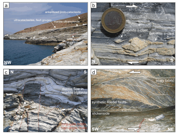
Figure 4. Stop 1 ,2 and 3
a) Stop 1: Granodiorite deformed by a decimetre spaced joint system along which fluids have bleached the rocks in an up to several centimetre wide zones. b) Stop 3: Foliation parallel vein filled with high-temperature skarn minerals (mainly garnet). Note the small apophyses normal to the veins cross-cutting the mylonitic foliation. c) Stop 2: Greenschist-facies shear zones with SW-directed kinematics. d) Stop 2: Orientation of dykes and brittle high-angle faults (lower hemisphere).
Following the main road towards the impressively fortified monastery of Taxiarches (Μονή Ταξιαρχών), various generations of dykes ranging in composition from dacitic to andesitic can be observed. The majority of these dykes are dacitic, record porphyritic structures, and generally contain the same minerals as the granodiorite. The dykes intruded into a shallow crustal level and generally follow the brittle conjugate high-angle normal fault pattern striking from WSW-ENE to WNW-ESE (Figure 4d). Whereas only some of the dykes are deformed by low-angle ductile to brittle / ductile shear zones or reveal minor ductile deformation at their margins, most of the dykes are associated and overprinted by brittle deformation. Therefore the dykes are frequently bordered by cataclasites, slickensides rarely showing formation of pseudotachylites.
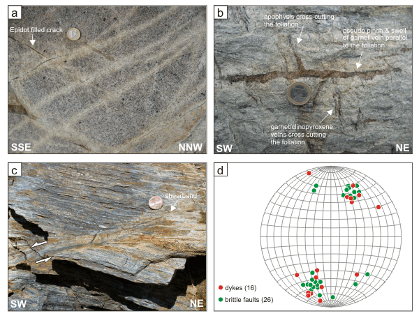
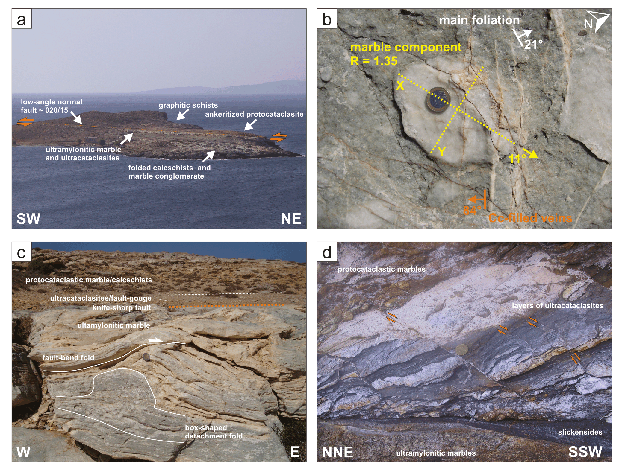
Figure 5. Stop 5
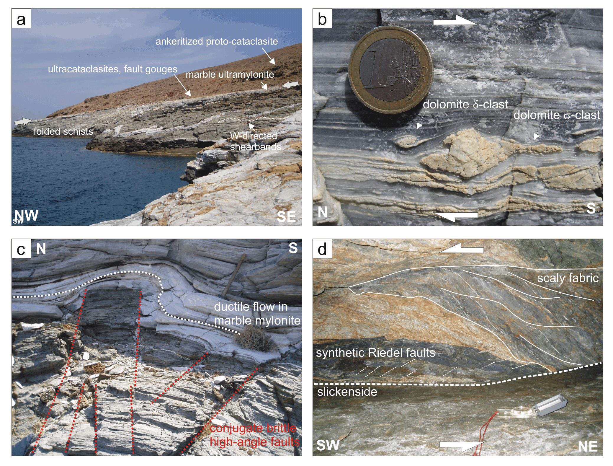
All photographs from Stop 5: a) Low-angle fault cutting through the peninsular of Platís Yialós. b) Deformed marble conglomerate. c) Detachment and fault-bend folds indicate shortening perpendicular to the stretching lineation. d) Zone of ultracataclastic deformation, separated by a knife-sharp fault from the ultramylonic marble below.
West of the monastery of Taxiarches, a small road leads towards the N to the peninsula of Platís Yialós, where a knife-sharp low-angle fault dips at 20° towards NNE (Figure 5a). There is a clear decrease in ductility of fault-related deformation moving up from lower to higher structural levels. Lithologically, the footwall of this low-angle fault consists of greenschists / calcschists and marbles with a conspicuous, several metre thick layer of marble conglomerates. The whole sequence dips at low angles towards NE and is folded along NE-SW trending fold axes with axial planes parallel to the main foliation. The marbles are coarse-grained and containing mainly quartz grains and up to millimetre sized white micas, as well as calcite. The marble components of the metaconglomerate have an oblate shape (k-values ~ 0.4), the long axes of which defining a clear ENE-WSW trending lineation (Figure 5b). The whole sequence is overprinted by sub-vertical WNW-ESE striking calcite-filled veins (Figure 5b) and high-angle ductile / brittle normal faults dipping towards NNE and SSW. The top of this structural unit is cut by a major ductile / brittle low-angle normal fault, dipping about 10°-20° towards NNE. Typically, these low-angle faults are characterized (not only on Serifos but in the whole Western Cyclades!) by a few metre thick, ultra-fine grained marble mylonite with a strong stretching lineation striking NNE-SSW. All macro- and micro-kinematic indicators reveal consistently a shear sense towards SSW. There is typically a strong shortening component perpendicular to the stretching lineation resulting in box-shaped detachment and fault bend folds (Figure 5c). A knife-sharp fault separates these ultramylonites from a several decimetre thick zone of multiple-generation, cohesive ultracataclasites / fault-gouges. Depending on the mineralogical composition, the ultracataclastic rocks form differently coloured, several centimetre-thick layers, which can be traced along several tens of metres. Clay-rich zones develop macroscopically visible P-foliations, which are offset along synthetic high-angle normal faults. Extension fractures partly filled with calcite have formed in more competent cataclastic layers. Y-shears generally record slickensides with NNE-SSW striking slickenlines. The shear sense is consistently directed towards the SSW (Figure 5d). This zone of ultracataclasites / fault-gouges is overlain by ankeritized protocataclasites of marbles and calcschists and graphitic schists. Extensive veining and alteration show evidences for massive rock-fluid interaction during deformation. Also within this overlying protocataclasites, up to metre-scale brittle / ductile shearbands record SSW-directed shear and upright detachment folds indicate a shortening component perpendicular to the shearing direction.
We interpret this ductile / brittle low-angle fault as a SSW-directed normal fault, which has been rotated in a NNE dipping position by up-doming of the island during intrusion of the granodiorite. Both conjugate high-angle and low-angle normal faults were synchronously active but high-angle faulting was still active in the brittle field, when movements on brittle / ductile low-angle faults had already stopped.
Figure 6. Stop 6, 7 and 8
a) Stop 6: Dyke overprinted by strong cataclastic deformation. b) Stop 6: Orientation of mode I and II faults (lower hemisphere). c) Stop 7: Brittle high-angle normal fault overprinting low-angle shear zone. d) Stop 8: Intrusive contact of the main granodioritic body.
A few hundred metres north of the village of Kéndarchos a strong cataclastic overprint is the result of a system of high-angle conjugate W-E striking faults. This major brittle fault zone marks the boundary between the greenschists / marble unit to the north and the amphibolite / orthogneiss rocks to the south. Several dykes follow the strike of the brittle faults but are themselves overprinted by strong cataclastic deformation (Figure 6a). Most of the slickenside dip at about 40°-50° towards SSW recording a clear lineation and a normal dip-slip component. Another set of normal faults dip towards NNE. These conjugate brittle faults are cut by metre thick zones of cohesionless cataclasites, which formed within W-E striking vertical opening-mode faults (Figure 6b). The high-angle normal faults deform near horizontal low-angle faults with a consistent SSW-directed shear and several metre offset (Figure 6c). These shear zones are associated with ductile fault drag but also with brittle SSW-dipping normal faults and almost vertical thrusts representing secondary syn- and antithetic Riedel faults, respectively. In general, the S-directed low-angle faults are overprinted by the conjugate high-angle normal faults documenting the ongoing roughly N-S oriented extension in the brittle regime.
Following the road in the direction back to Livádhi the amphibolites and orthogneisses become strongly deformed with a mylonitic foliation dipping at about 50° towards N. Towards the contact with the massive granodiorite body, steep S-dipping brittle normal faults are intruded by dacitic dykes. The contact of the granodiorite with the orthogneisses / amphibolites is sharp and discordant, cutting the mylonitic foliation at a high angle (Figure 6d). The intrusive contact post-dates earlier dykes, some of which contain xenoliths of the mylonitic host rocks. Dacitic to andesitic dykes intruded both the granodiorite and its host rocks.
Traverse 2 demonstrates the complex structural overprinting of high-temperature mylonitic striped-gneisses with low-grade greenschist-facies low-angle shear zones separating coarse grained marbles above the fault from ultramylonitic marble below. Most interestingly, the low-grade ductile shear zones also cut the granodiorite thereby constraining, together with the geochronological data, the SSW-directed movement to roughly 7-8 Ma. See Figure 7 for the location of excursion stops.

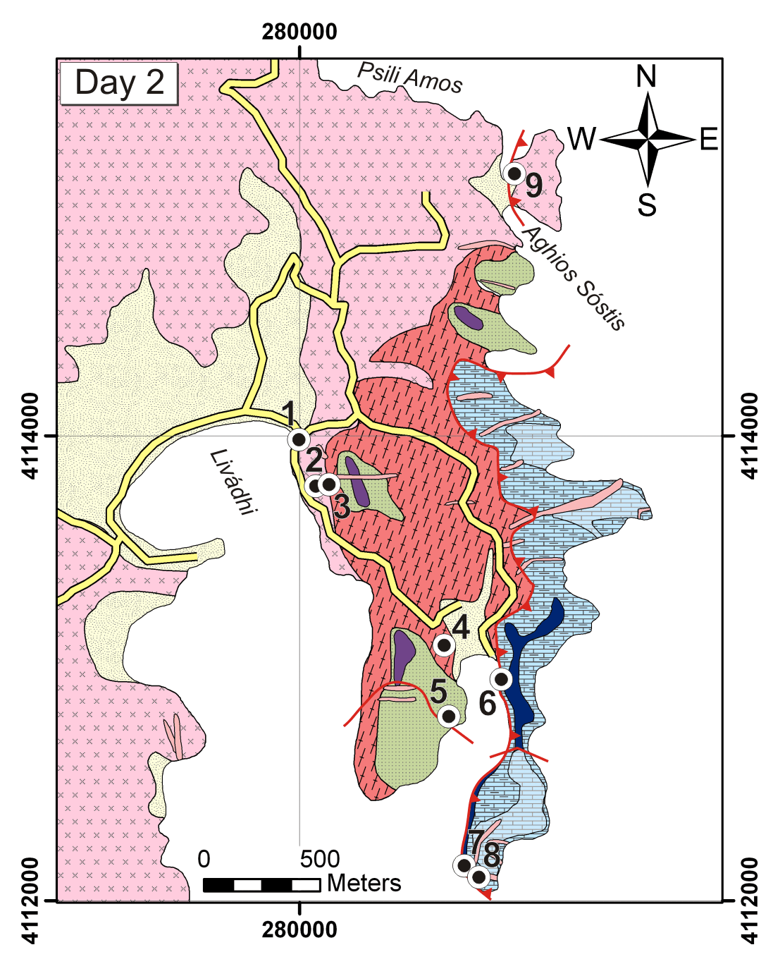
Start the excursion from Livádhi and walk to the eastern end of the beach. At this stop the E margin of the main granodiorite intrusion is exposed. Although the main intrusive body to the W is undeformed, the granodiorite at this location is slightly sheared recording a SE dipping foliation. Macroscopically, the granodiorite is strongly altered and bleached along numerous centimetre to decimetre spaced joints. The granodiorite is cut by several dykes of similar mineralogical composition.
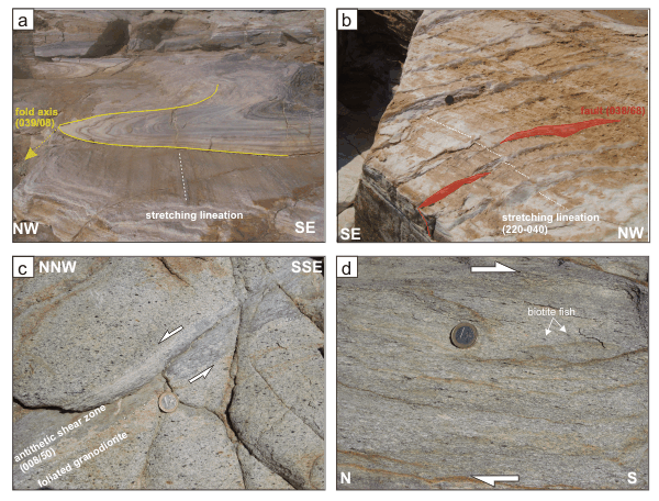
Follow the road along the bay towards the south to the “Studios Niovi”. Directly behind the apartments climb up the stairs to Stop 2, where the intrusive contact between the granodiorite and the mylonitic orthogneiss is exposed. The near-horizontal mylonitic foliation records a strong N-S oriented stretching lineation. In thin sections, the microstructures record layers of coarse recrystallized quartz alternating with layers of fine-grained recrystallized feldspar indicating deformation temperatures above ~500°C, typical for the striped gneisses. Note that contrary to other locations, the intrusive contact is parallel with the mylonitic foliations of the gneisses and difficult to detect. Climb up about 30 m (Stop 3) where the mylonitic orthogneisses contain decimetres up to metres thick garnet dykes, which belong to the late-tectonic high-temperature skarn formation with respect to the mylonitic foliation, prior to the granodiorite intrusion. Although some garnet dykes intruded parallel to the mylonitic foliation, periodic thickening and thinning of the dykes indicate moderate pinch and swell formation during further deformation. Additionally, some of the skarn veins cross-cut the foliation with local drag effects probably related to ongoing deformation (Figure 8a). The whole outcrop is intruded by a late stage dykes – related to the granodiorite intrusion – dipping at 30° towards E cross-cutting all major structures.
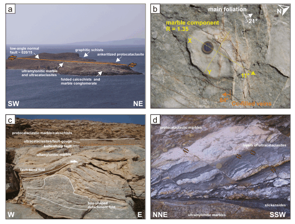
Follow the main road along the bay of Livádhi towards the southeast, passing from undeformed and foliated granodiorites to orthogneiss mylonites at structurally higher levels. Leave the road at the first turn and head towards the west-side of a small bay. At Stop 4, a metre thick dyke striking NW-SE is cut by low-grade ductile shear zones. These subhorizontal low-angle shear zones localize in several centimetre thick ultra-high strain zones with SSW-directed shear. Macroscopically these zones can be recognized by their very fine grain size and the black colour. Microscopically, the ultramylonites contain clasts of magmatic feldspar, quartz and biotite forming spectacular shear sense criteria such as sigma-clasts, delta-clasts and mica-fish embedded in an extraordinarily fine-grained matrix (Figure 8b). Elongated single grains of quartz are formed by dislocation glide along the basal glide plane. Aggregates of very fine grained quartz grains record a shape-preferred orientation developed by low-temperature grain boundary migration suggesting temperatures of the shear deformation between 300-400°C (Figure 8b). The total offset of these shear zones is limited due to their thickness of only a few centimetres. However, this observation is very important for the estimation of intrusion depth, because it demonstrates that the dykes, which are generally considered to intrude into high crustal levels following brittle high-angle normal faults, are locally affected by low-grade low-angle ductile shear zones.
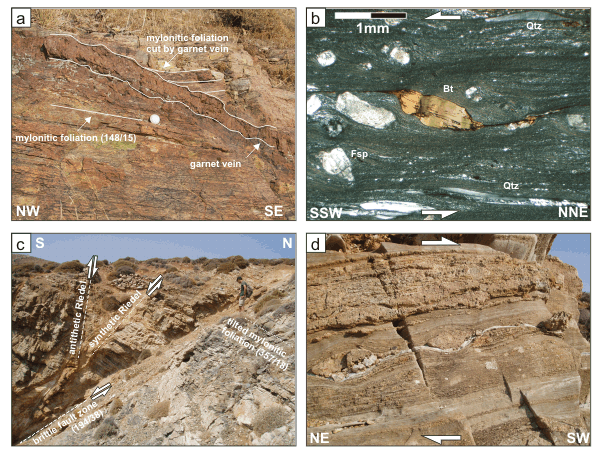
Figure 8. Stop 3, 4, 5 and 6
a) Stop 3: High-temperature skarn vein, cross-cutting the mylonitic foliation. b) Stop 4: Thin section of ultramylonitic andesitic dyke. c) Stop 5: Brittle high-angle normal fault. d) Stop 6: Shearband boudinage in marbles.
Follow a small trail on the west side of the bay towards the south. Numerous W-E striking high-angle brittle faults with a local throw of several metres cut through all lithologies and represent the latest stage of N-S extension. The faults contain mainly non-cohesive cataclasites with cemented fault cores bordered by slickenside with S-plunging slickenlines. Brittle kinematic indicators (e.g. monoclinic cataclastic aggregates, congruous steps, pluck holes or spall marks) record top to S-directed normal offset. Most of the major brittle fault zones are associated with a network of secondary fractures with syn- and antithetic Riedel geometries (Figure 8c). Due to N-tilting between the S-dipping brittle faults, the mylonitic foliation of the host rocks is rotated from S into N-dipping orientations.
Return the by same trail and cross the bay to the east-side. Follow a small path through a goat-gate and walk along the cliffs towards the south. At lower structural levels, the high-temperature fabric of mylonitic orthogneisses is overprinted by low greenschist-facies localized shearbands. At higher structural levels, the gneisses are interlayered with impure marbles, schists and quartzites. This generally E-dipping layered unit is strongly stretched forming boudinage structures indicating SW-directed shearing. Locally, the rocks are deformed by several generations of folding forming complex refold structures: Isoclinal folds with NW-SE striking fold axes record gently E-dipping axial planes, which are parallel to the general mylonitic foliation. Among other fold orientations upright NE-plunging folds are observed. All structures are overprinted by ultrafine-grained ductile to brittle / ductile shearbands and up to metre-thick low-angle shear zones, which mainly localize in the marbles recording SW-directed shear (Figure 8d).
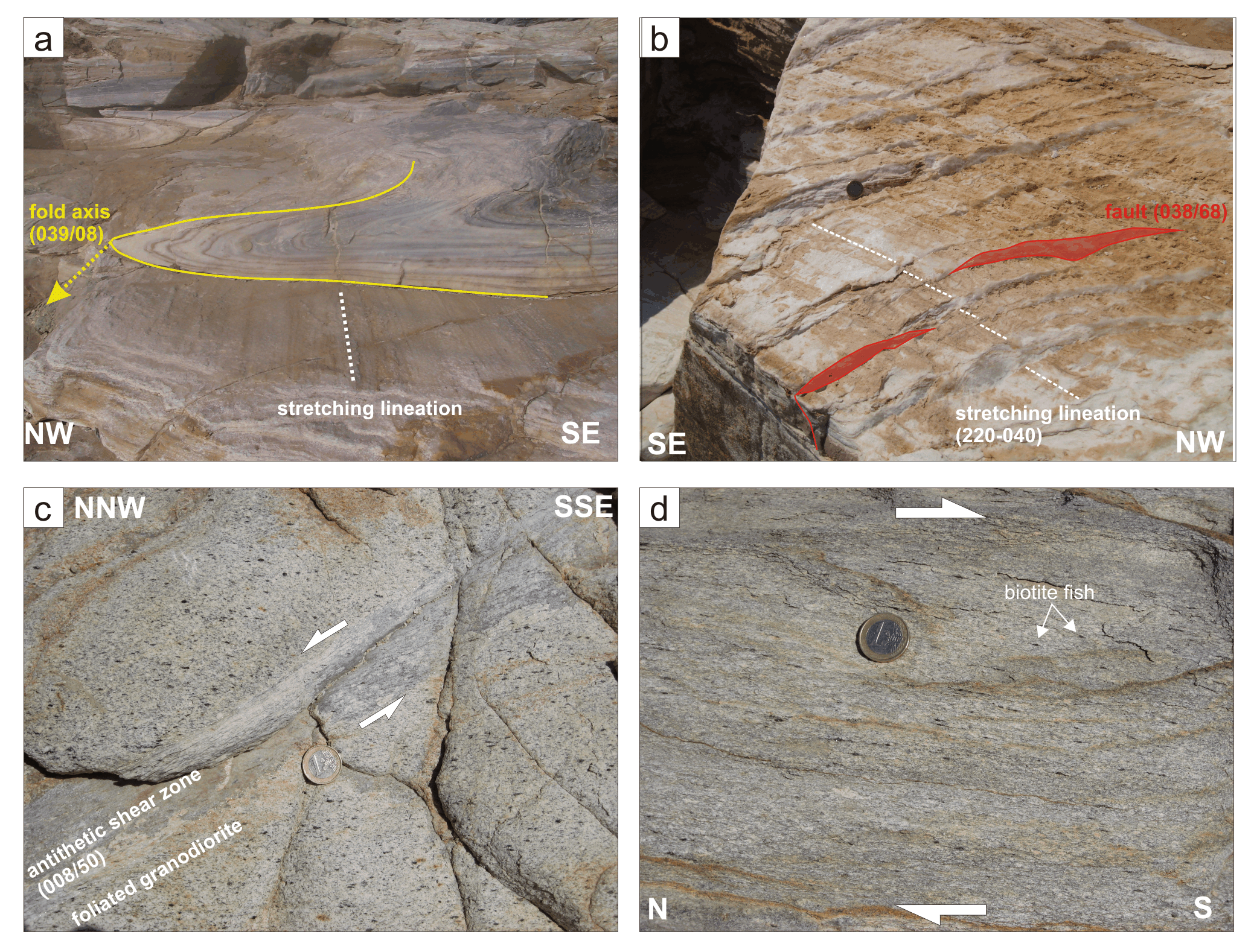
Follow the cliffs to the south until you reach the southernmost part of the peninsula. At Stop 7, the continuation of the lithologies and structures of Stop 6 are observed. Several low-angle shear zones with ultrafine-grained calcite contain up to metre sized clasts of orthogneiss mylonites revealing consistent S-SW-directed shear sense. At a structural position several metres above this location at Stop 8, coarse grained marbles with millimetre-sized calcite crystals represent the hanging wall of the low-angle low-grade shear zones. The marbles record a clear NE-SW-striking stretching lineation, which is parallel to isoclinal folds with axial planes parallel to the mylonitic foliation (Figure 9a). Following the trail to the east side of the peninsula, the marbles experienced polyphase folding together with amphibolites and schists forming dome and basin refold structures. The most prominent folds have W-E striking axes with steeply N-dipping axial planes. The coarse recrystallized marbles, probably formed during higher grade metamorphic conditions, are overprinted by brittle / ductile centimetre-spaced mesoscopic normal faults, dipping steeply towards NE (Figure 9b). The whole sequence is intruded by several generations of undeformed dykes.
Figure 9. Stop 8 and 9
a) Stop 8: Isoclinal fold with fold axis parallel to the stretching lineation in coarse-grained marble. b) Stop 8: Brittle / ductile faults in marbles at high angle to the mylonitic foliation. c) Stop 9: Ductile shear zone in the granodiorite. d) Stop 9: Strongly sheared granodiorite.
Return to the road and follow the road to the north to the beach of Ághios Sóstis. At this location, the progressive ductile deformation of the otherwise undeformed granodiorite can be observed. West of the beach, the granodiorite is overprinted by a weak continuous E-dipping foliation marked by oriented biotite and hornblende. West of the beach at structurally lower positions, the foliated granodiorite is cut by several up to decimetre thick ductile shear zones (syn- and antithetic refers to the overall S-directed shear sense, Figure 9c). Continuing to the east towards higher structural levels, the granodiorite is deformed into a low greenschist-facies mylonite with an E-dipping foliation and NNE-SSW oriented stretching lineation. SCC’-fabric, clasts of biotite with fish-like geometries (Figure 9d), fractured and rotated feldspars and shape and lattice preferred orientations of dynamically recrystallized quartz grains record consistently a SSW-directed displacement. Epidote veins and bleached joints dipping at steep angles towards SW overprint the mylonitic foliation. This important outcrop proves the intertectonic intrusion of the Serifos granodiorite pluton.
Figure 10. Traverse 3

Stops of Traverse 3 in the southwest part of Serifos. For the index of the geological map see Figure 2.
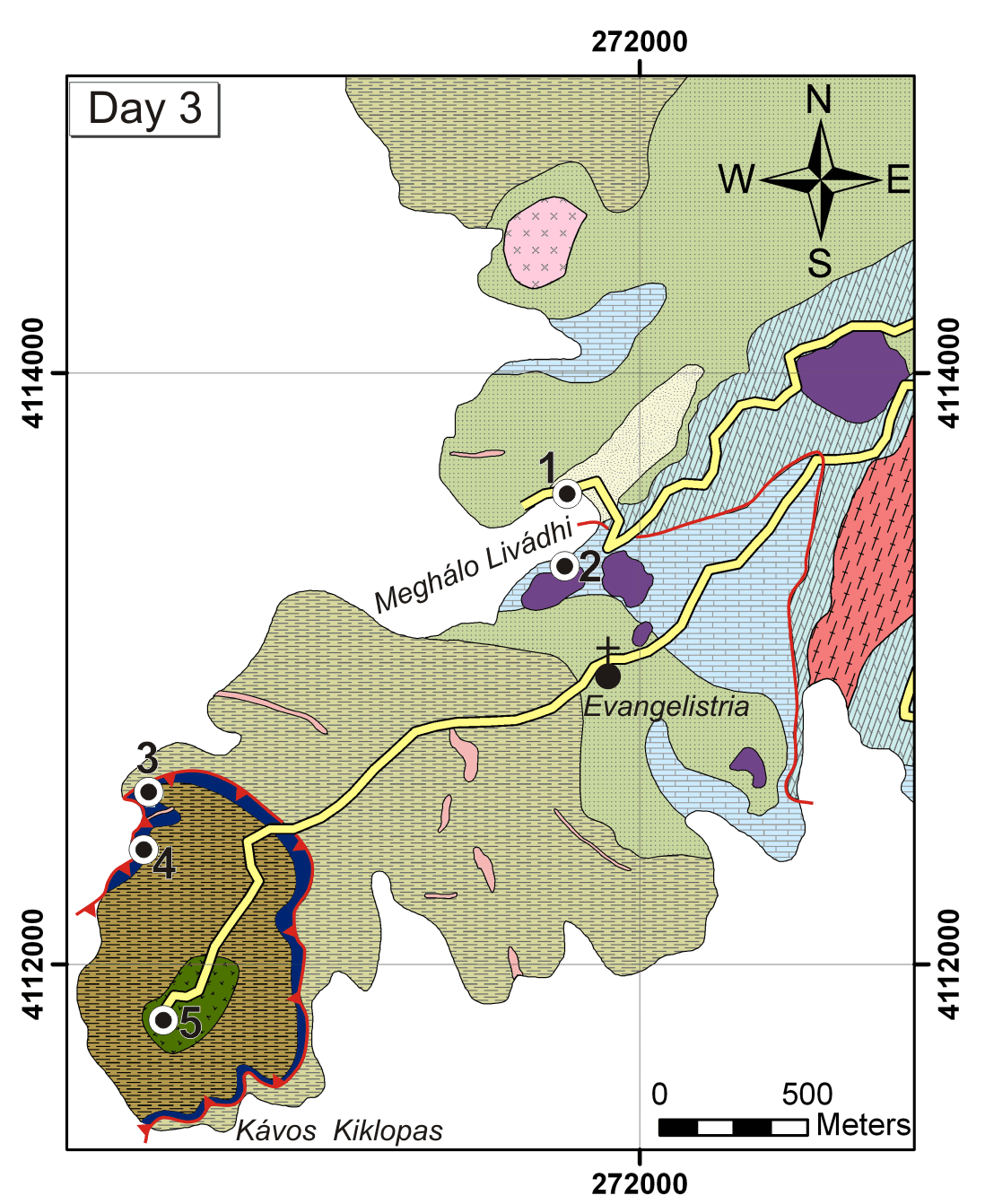
Traverse 3 leads to the marbles in Meghálo Livádhi with abundant spectacular boudinage structures showing SSW-directed normal fault kinematics under greenschist-facies conditions to cataclastic overprint. Above an impressive brittle / ductile low-angle normal fault ankeritized marbles / calc-schists and highly altered serpentinites / talc schists are exposed. See Figure 10 for the location of excursion stops.
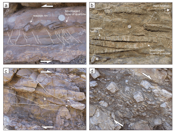
The first stop is located directly at the north-end of the beach of Meghálo Livádhi left of the abandoned neoclassical building in Meghálo Livádhi (built in 1869, that was used to be the headquarters of the mining company “Serifos-Spiliazeza”). Directly next to the building, towards the west, is a monument in memory of mining workers, who were killed during a labor dispute in 1916. Just below the monument, there are several small outcrops of marble mylonites with spectacular boudinaged layers consisting mainly of quartzites (Figure 11a). The boudins are generally asymmetric recording both, domino- and shearband boudinage, developed under SSW-directed shear. The layered marbles contain conjugate fractures, which have been rotated into the shear direction giving rise to the development of complex flanking structures. Both marbles and quartzite show evidence of dynamic recrystallization with a strong shape preferred orientation of the crystal shapes. Additionally, the quartzites record a pronounced orientation of the crystallographic c-axes, consistent with a SSW-directed shear. The boudins and the necks between the boudins show reaction rims and the growth of calcsilicate minerals, amphibole and talc giving evidence of late stage alteration processes.
The outcrop below the road, directly at the beach, gives a spectacularly three-dimensional exposure of rod-shaped boudinaged quartzite layers on xy-sections parallel to the main foliation of the marbles (Figure 11b). The stretching direction indicated by the separation of the boudins and the stretching lineation are not exactly parallel but show angles up to about 20° varying around general N-S orientations. Although the boudins are strongly fractured by conjugate fault sets roughly perpendicular to the boudin-necks, no significant separation in the intermediate stretching direction is observed. The shear-sense indicated by the domino and shearband-type boudinage is generally S-directed.
Figure 11. Stop 1 and 2
a) Stop 1: Domino-type boudinage in marbles (xz-plane). b) Stop 1: Similar boudinage like in (a) but in a section parallel to the foliation (xy-plane). c) Stop 2: Brittle / ductile normal and thrust fault in marbles. d) Stop 2: Sheared marble with quartzite boudins.
At the abandoned mining site and ship loading point in the south part of Meghálo Livádhi bay, the marbles are overprinted by a broad zone of brittle / ductile to cataclastic deformation broadly parallel to the gently SW-dipping metamorphic layering. Brittle / ductile secondary fault zones form at high- and low angles to the metamorphic layering within the more competent marble bending into foliation-parallel orientations in more incompetent phyllonitic layers. High-angle fault zones rotate into the shear direction developing flanking structures with reverse drag of the main foliation. Low-angle fault zones dip either gently towards SW or NE (Figure 11c).
Several decimetres- to metre-thick, brittle / ductile to cataclastic fault zones localize foliation-parallel into the boudin-rich marbles dipping at about 50° towards SSW. Within these shear zones, the quartzite boudins are completely dismembered and broken into angular fragments (Fig 11d).
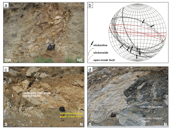
Figure 12. Stop 3 and 4
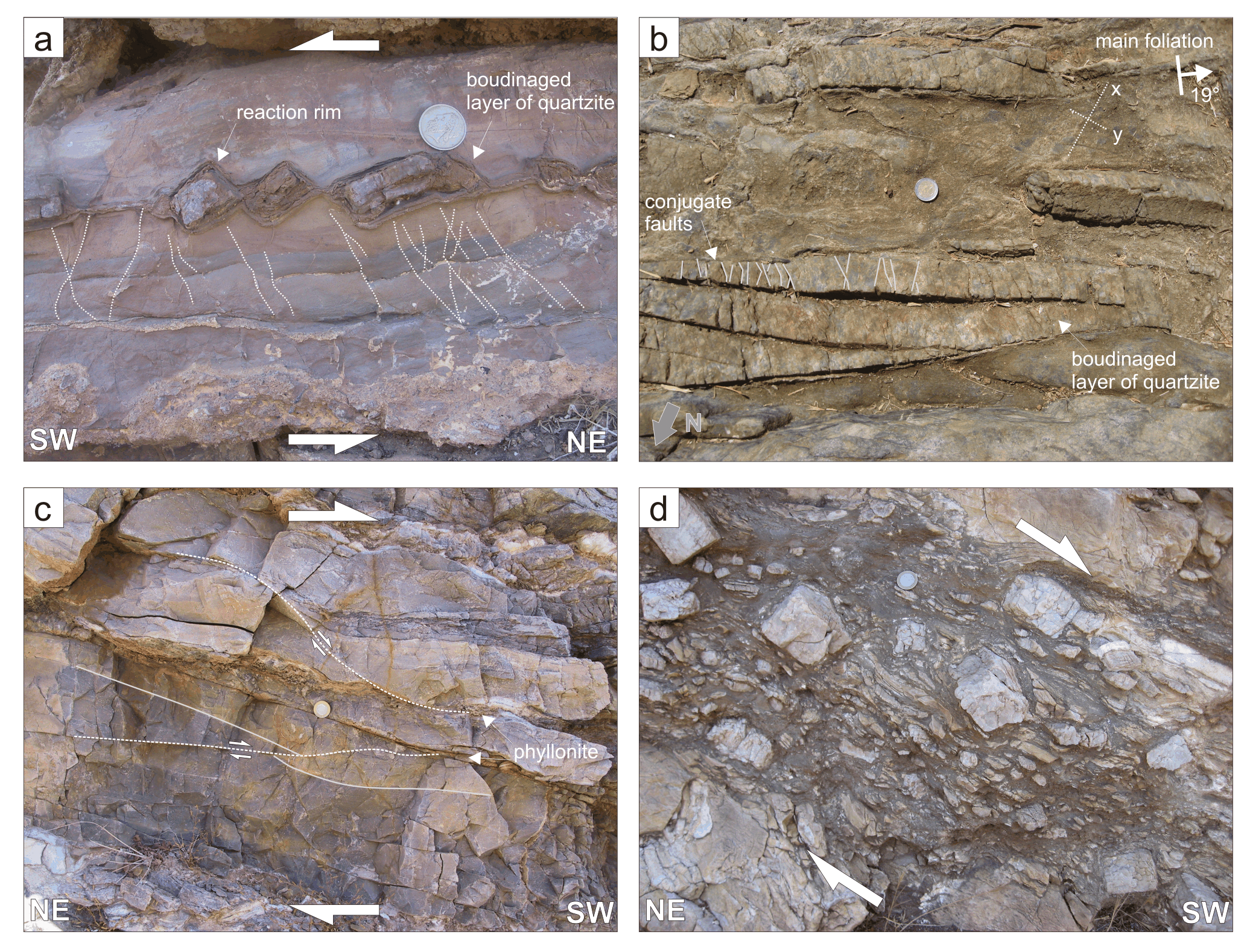
a) Stop 3: Low-angle normal fault surface at Kávos Kíklopas. b) Stop 3: Dolomite sigma- and delta-type clast geometries in calcite marble. c) Stop 4: Brittle high-angle normal faults interacting with ductile flow in low-angle marble shear zone. d) Stop 4: Scaly fabric in ultracataclasites and fault gouges.
Follow the road to the head of the peninsular Kávos Kíklopas (Κάβος Κύκλωπας). About 1 km southwest of the Monastery of Evangelistria there is a distinctive geomorphological saddle which marks the location of the W-dipping low-angle normal fault of Kávos Kíklopas. Park here and follow the thin layer of ultramylonitic, fine-grained marbles to the cliffs on the west-side of the peninsula. A knife-sharp fault surface dipping about 10° towards W, separates ankeritized protocataclasites in the hanging wall from folded schists and marbles in the footwall (Figure 12a). Within the schists, several metre-sized shearbands overprint earlier structures indicating W-directed shear. Directly below the knife-sharp fault surface, several metre thick ultramylonitic and partly ultrafine-grained marbles show intense NNE-SSW striking stretching lineations. Dolomitic layers are fractured and boudinaged into isolated fragments deforming into sigma- and delta-type clast geometries record ductile SSW-directed shear (Figure 12b). Generally, the marble mylonites have been deformed under decreasing low-grade metamorphic conditions recording gradual transitions from ductile, brittle-ductile to brittle deformation mechanisms. Relict pinch-and-swell boudinage of dolomite layers in the calcite marbles indicate the initially lower competence contrast resulting from higher-grade metamorphic conditions. At the brittle / ductile transition, the marble mylonites still facilitated ductile low-angle SSW-directed shearing, whereas the rocks in the footwall accommodated extension along conjugate roughly W-E striking high-angle normal faults (Figure 12c) indicating the simultaneous activity of high- and low-angle normal faults.
Follow the cliffs to the south, where the cataclastic part of the Kávos Kíklopas normal fault can be studied. The localized fault surface, that separates the cataclasites in the hanging wall from the marble mylonites in the footwall, is marked by slickensides and are parallel to the mylonitic foliation and by NNW-SSE striking slickenlines that, in turn, are parallel to the ductile stretching lineation in the marbles. Above this surface, a several decimetre-thick zone of ultracataclasites and fault gouge developed, followed by protocataclasites in the hanging wall. The foliated cohesive ultracataclasites show a complex array of variable anastomosing surfaces (scaly fabric) breaking the rock into sigmoidal shaped chips of less fissile material with polished surfaces and fine lineations consistent with SSW-directed shear (Figure 12d). This kinematic interpretation is supported by the observation of synthetic Riedel fractures dipping 20°-30° towards SW. Different coloured layers of cataclasites record different composition of source material and different degrees of finite deformation. Numerous systems of syn- and post-tectonic veins, alterations and pronounced ankeritization of the protocataclastic hanging wall rocks suggest that the fault represented an important fluid pathway during deformation.
Walk back to the road and continue the road towards southwest until its termination. Clearly in a structural hanging wall position of the Kávos Kíklopas normal fault and within a zone of distinct ankeritization, the road-cut exposes a serpentinite body. The foliated serpentinite mainly consists of antigorite / crysotile, chlorite and talc. Less deformed ultramafic lenses show relics of orthopyroxene. These serpentinites probably belong to similar meta-ophiolithic remnants reported from several Cycladic islands (e.g. Bröcker and Pidgeon, 2007). These possible ophiolite fragments are considered as Upper Tectonic Unit of the Cyclades (Dürr et al. 1978; Schliestedt et al., 1994).