Extensive geological and geophysical studies have been conducted in Indus Offshore basin during the last two decades (Raza et al., 1989 and 1990; Ahmed et al., 1994; Shuaib and Shuaib, 1994; Amir et al., 1996; Siddiqui, 1997; Biswas, 1982; Khan and Raza, 1986; Qadri, 1984; Raza, 1997; Raza and Ahmed, 1990; Bowles, 1997; OGDC-PCIAC, 1986; Naveed, 1987; and Shah, 1996).
The study area, lies between latitudes 23° 15’ to 24° 30’ N and longitudes 66° 30’ to 67° 30’ E, is the part of Indus offshore basin of Pakistan and forms the continental shelf that is about 120 Km south of Karachi city and is situated between the Gulf of Kutch and Murray Ridge spreading over 20,000 square Kms. Indus offshore basin falls in the Type IV (Intermediate Crustal type): an Extra-continental Downwarp to Small Ocean Basin combined with Tertiary Delta Basins toward Oceanic Areas of Halbouty (1970) and Klemme (1980) and Extra-continental Trough Downwarp of Riva (1983). The average shelf break to the west of the Indian continent occurs at about 200 m water depth whereas in the study area it is less than 150 m (Naini and Talwani, 1983). General stratigraphy of the Indus offshore basin suggests a number of source rocks in the area (Raza et al., 1990), namely, the shales of Sembar and Goru (Cretaceous), Bara (Paleocene), Laki (Eocene), Nari (Oligocene), Gaj or equivalent facies (Miocene) and the limestones of Mughalkot (Cretaceous). Hard geochemical data from Kirthar Range (Seemann et al., 1988) indicates organic richness (above average TOC values) in samples from Sembar, Goru, Pab, Dunghan, Ghazij and Nari formations in onshore southern Indus basin. The geothermal gradient in the Indus offshore basin is optimum ranging from 1.5oC/100m to 3oC/100m (Khan and Raza, 1986).
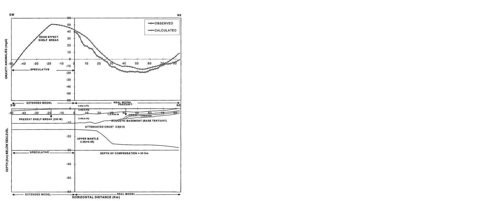
In the present study, multidisciplinary data from seismic, gravity, magnetic and bathymetry was integrated to obtain a geologically plausible model from the deep crustal structure and also for the hydrocarbon prospects in Indus offshore basin beneath the seismic line PC/9074-86. The overall workflow of integrated geophysical studies in Indus offshore basin has been summarized in Figure 1.