The study area is mainly drained by four perennial streams such as Kurang River, Gumrah Kas, Malal Kas and Lei Nullah, and many other seasonal streams, which are either intermittent or ephemeral (Figure 1). The water table in the pre-existing wells vary from 10 to 90 feet in the National Park area and 42 to 165 feet in the Islamabad Sectorial area. The series of stratified confined aquifers have been identified during a recent crash drilling program by the Capital Development Authority and Oil & Gas Development Corporation in different sectors such as G-10, F-8, F-10, and H-8 etc. These aquifers are mainly comprised of gravels, gravels and boulders, well-defined large bed of limestone boulder (partially fractured), and friable sandstone. The hydraulic characteristics of these aquifers widely vary due to the nature of upper confining layer of aquiclude and/or semi confining layer of aquitard.
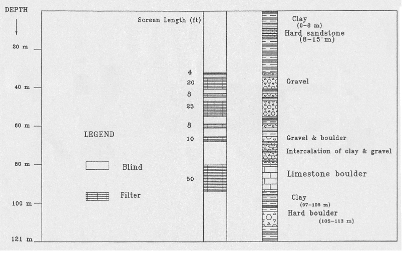
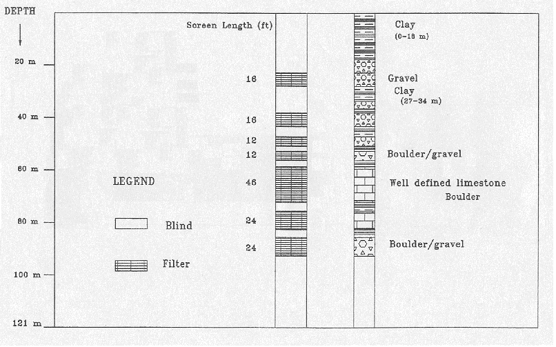
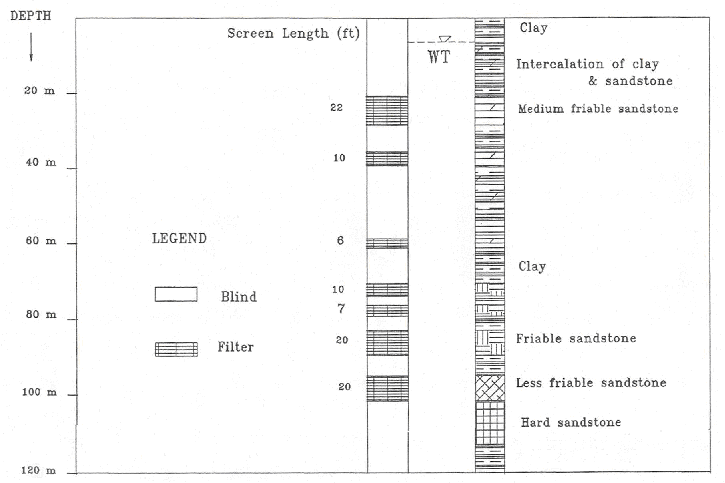
The geophysical well-logging consisted of natural gamma and resistivity sonde is carried out in dozens of trial bores, 350 to 400 feet deep, to make the filter design and to estimate the ultimate well yield prior to the advancement of further reaming/development operation. Few of them for sectors F-10, H-8 and G-10 are shown in (Figure 2), (Figure 3) and (Figure 4) respectively, which show a complete filter design and subsurface lithological features. In these sectors, yield of the permeable strata is also estimated by assuming two hydraulic gradients ( i = 0.007 and i = 0.01 ) with the suitable hydraulic conductivities of the gravel and boulder formation. Darcy’s law expressed in terms of groundwater flow notation is used to estimate this yield. The estimated yield for boreholes located in sectors F-10/4, H-8 and G-10 appears to fall in the ranges of 15,000 to 20,000 U.S. gph (0.55 – 0.74 cusecs), 17,000 to 22,000 U.S. gph (0.63 – 0.81 cusecs), and 10,000 to 12,000 U.S. gph (0.40 – 0.44 cusecs) respectively.
In some sectors, the water table in the shallow aquifer is highly vulnerable to contamination due to the processes of infiltration and percolation, which carry along different volatile pollutants of sewerage waste and effluent industrial waste etc. Recent spread out epidemic disease of jaundice in Islamabad is water borne possibly resulted due to the use of contaminated groundwater from wells in sector G-10. These old wells, now completed abandoned, were penetrated adjacent to the perennial nallah whose flow is mainly maintained by the sewerage water. The upper portion of the shallow aquifer is being recharged by this nallah.
New well design based on the geophysical well-logging by a sophisticated machine starts from deeper horizon (at least 80 feet) and whatever water either perched and/or seepage in the upper horizon has been completely sealed by the M.S. Pipe (blind pipe) to control the contamination (Ahmad et al., 1992).