GIS is built upon knowledge from geography, cartography, computer science and mathematics and can be applied in any field, directly or indirectly. The use of GIS in the natural resource industry is widely recognized and has been used extensively for the exploration of groundwater resources and hyrdogeological investigations (Nath et al., 2000; Chi and Lee, 1994; Laurent et al., 1998; Gardino and Tonelli, 1983; and Gustafsson, 1993), mineral exploration (Ramadan et al., 1999 and 2003), and hydrocarbon exploration (Williams, 2000; Porter et al., 2000; Shah, 2003 and Iqbal, 2004).
Williams (2000) used satellite remote sensing technology in the search for new petroleum reservoirs in South Asia both onshore and offshore. Onshore, the arid terrain and superb exposures were found in the Makran, Kirthar and Suleiman Ranges that provided classic areas for geological and structural interpretation from space. Offshore, several oil seeps were detected in the frontier basins of the Indus deep water by satellite radar. The study also presented numerous examples of the increasing range of remote sensing techniques now available to the modern explorer with special concentration on offshore seep detection.
Seismic operations are becoming more difficult to conduct due to culture, permits, restrictions, divided interests, and complex acquisition methods used to improve quality of the final seismic product. Valuable information is gathered and compiled during feasibility, evaluation and design stages. Minerals, permitting, and pre-survey / hazard mapping information is provided prior to, and during the advance, survey and drilling operations. As 3D seismic surveys continue to grow in size and complexity, logistics and planning play a vital role in determining the efficiency and profitability of a seismic operation. The seismic metadata (information describing the seismic data) associated with these surveys is also rapidly increasing in volume and variety, yet is still stored in disparate locations such as trace headers, co-ordinate files and paper and electronic observer logs. With the increasing popularity of time lapse seismic, this metadata can be considered to be used for the pre-plan information of a repeat seismic survey, and it is consequently more important than ever that it be efficiently gathered, stored, analyzed and archived.
Porter, et al. (2000) optimized the seismic metadata with MATRIX®, a system with effective implementation of GIS for managing today’s complex 3D seismic projects as mentioned above. This GIS-based system along with the open database architecture, data connection and load wizards, report and analysis builder, and web-enabling technology helped in managing, analyzing, and presenting information from inception to completion and provide benefit to a wide verity of user groups involved in the project ranging from crew clerk to field geophysicist, seismic processor to operations manager, or drill push to safety auditor, and would enabled these users to enter, access, report, and perform analysis to support decision making.
As mentioned earlier, the increasing demand of GIS and Remote Sensing revealed many projects locally as well as internationally. LMK Resources (formerly: Mathtech Pakistan (Pvt.) Ltd.), a petroleum information technology company, implemented GIS-based Exploration Management System (EMS) in Directorate General of Petroleum Concessions (DGPC), Ministry of Petroleum and Natural Resources, Islamabad (Shah, 2003). They are the custodians of all Exploration & Production (E&P), Geological and Geophysical (G&G) data for Pakistan on the behalf of DGPC. The data submitted by various companies was previously managed manually and it was very difficult to find any desired data within a reasonable amount of time. Many other problems and issues were data redundancy, manual work, heterogeneous data formats, no standard nomenclature for data labeling, hard to retrieve required information, much efforts required even for simple reports, more personals required for record management, difficult data mobilization, data ownership and responsibility not clearly defined, etc. These problems were studied extensively and an integrated digital POSC (Petrotechnical Open Standards Consortium) compliant database, Exploration Management System (EMS) was developed. It not only became one of the most popular information and management tool for exploration companies in Pakistan as well as abroad but it also helped the country to have the second most organized E&P database in the world after Norway (Shah, 2003). Major domains covered in it include lease information, wells information, production information, seismic surveys and technical library data along with its front-end GIS MapPlus© (Figure 1).
Figure 1. MapPlus
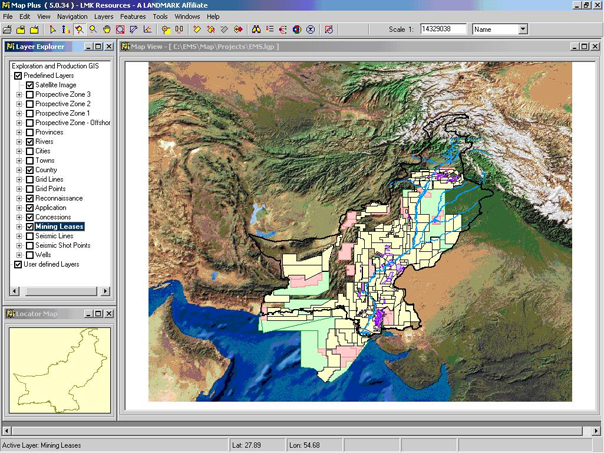
The Geographic Information System presenting selected E&P blocks data with satellite image in the background (After Shah, 2003).
MapPlus© is an interactive E&P data management tool with advanced capabilities to browse and manage spatial and tabular data, which helps geoscientists to visualize all updated oil and gas related activities on an interactive and customized GIS for quick analysis and decisions. It is specifically tailored to meet the needs of data managers, technicians, data operators, geophysicists, geologists and engineers. Some highlighted features of the GIS include; ESRI shape files based multi-layers map display, provides up-to-date base map for E&P activities, user-friendly and menu-driven interfaces, enhanced annotation and layer management, overlay high-resolution satellite image, run-time shape files generation from the underlying database, object identification, customized legend editors, generation of seismic base maps, basic and advanced navigational features, spatial search and selection, XML based project handling, comprehensive projection, query, threshold, and grid managers, thematic mapping, document hyper-linking, to-the-scale map printing, data export, generation of web pages and many more. It is so comprehensive and customizable that users directly or indirectly related to oil and gas sector can benefit from it very conveniently.
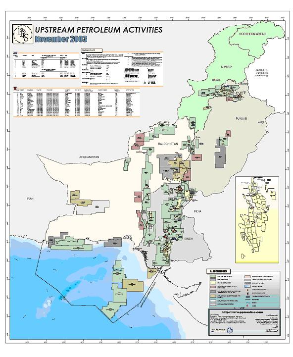
Implementation of Geographic Information System has not only helped the organization to maintain its exploration monitoring data up-to-date for over a decade rather it has also proved useful in generating self-revenue through the services like data management packages and PPIS (Pakistan Petroleum Information Service) etc. The PPIS is a unique information service that provides updates on Pakistan's upstream exploration activities. It has a history of providing vital information to the E & P industry. The service also includes digital and hardcopy versions consisting of monthly reports and attractive large scale Maps. It also provides a standard base map that is being currently used by all E&P companies for upstream petroleum activities (Figure 2).