Regional geological setting
The present position of Sardinia and Corsica islands is due to a 30° anticlockwise rotation of the Corsica-Sardinia block away from Europe caused by opening of the Western Mediterranean Ligurian-Provençal basin. The age of the rifting phase is dated to Oligocene (from 30 to 24 Ma) followed by a short Early Miocene oceanic accretion (ages ranging from 23 to 15 Ma, Ferrandini et al., 2000 and references therein). Then the structural pre-drift directions, namely Variscan, have to be restored of ~ 30° with respect to the stable Europe.
The largest part of Sardinia and Western Corsica islands is made up of a Permo-Carboniferous batholith emplaced between 340 and 280 Ma into a Variscan basement which crops out more extensively in Sardinia than in Corsica.
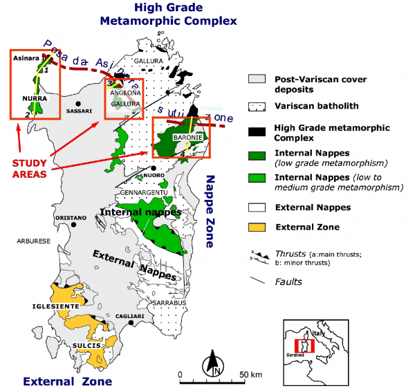
In northern Sardinia and in central and southern Corsica the pre-Permian basement has been affected by Variscan tectono- metamorphic imprint. This basement consists mainly of high-grade metamorphic rocks and was termed the "inner zone" by Carmignani et al. (1979) ((Figure 1)), and according to these authors it could represent the witness of a continental collision. The different structural Variscan zones were defined in Sardinia where Variscan metamorphic formations widely crop out and were more extensively surveyed.
Figure 1. Tectonic sketch-map of the Variscan belt in Sardinia
Tectonic sketch-map of the Variscan belt in Sardinia and location of the study areas (from Carosi et al., 2005).
Trace of geological cross section: 1. Asinara Island; 2. Nurra peninsula; 3. SW Gallura region; 4. Baronie region.