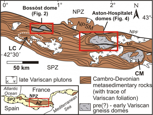
The Variscan core of the Pyrenees, the Axial Zone, consists of three major tectonic elements: Cambrian to Devonian metasedimentary rocks, pre- or early-Variscan orthogneisses, seated in Cambro-Ordovician strata, and Late Carboniferous granitic plutons. The Axial Zone is separated from the Alpine fold and thrust belts of the Pyrenees by the steep North Pyrenean fault zone and south-dipping thrusts (Nogueras Zone) to the south. Within the Axial Zone gradually deeper structural levels are exposed towards the east (Majeste-Menjoulas & Debat 1994). The most striking structural features are elongated structural-metamorphic domes aligned parallel to the E-W trend of the Axial Zone (Figure 1). They are composed of cores of orthogneiss gneiss or granitic intrusions mantled by greenschist to amphibolite facies Cambro-Ordovician schists. The metasedimentary rocks in the proximity of the dome cores are of medium to high metamorphic grade and possess a distinct flat-lying schistosity, termed infrastructure. Away from the core zone metasedimentary cover rocks are gradually less metamorphosed and display a steeper, subvertical main foliation, termed suprastructure. While the infrastructure is thought to represent deeper structural levels, the suprastructure is inferred to be developed into shallower levels (Carreras & Capella 1994). The temporal relationship of infra- and suprastructure is reflected in the various tectonometamorphic models evoked for the evolution of the Axial zone:
Figure 1. Sketch map of the Axial Zone
Sketch map of the Axial Zone (AZ) of the central and eastern Pyrenees with the three major tectonic elements and the trace of Variscan foliation. CM - Canigou massif; LC - Lys-Caillaouas massif; MF - Merens fault; NPF - North Pyrenean fault; NPZ - North Pyrenean Zone; NPSM - North Pyrenean satellite massifs; SPZ - South Pyrenean Zone. Modified after van den Eeckhout & Zwart (1988) and Gleizes et al. (1997).
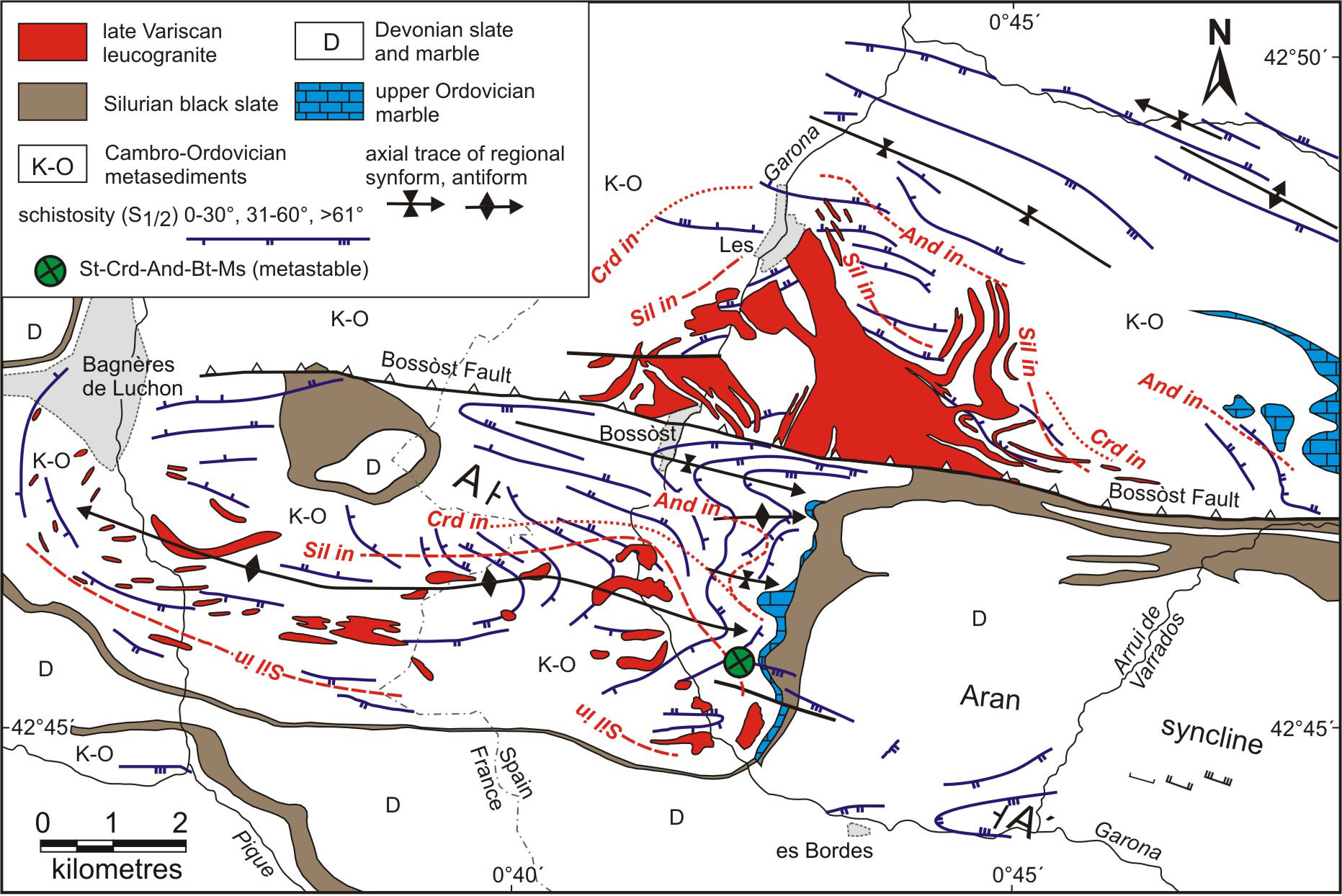
Figure 2. Tectonometamorphic map of the Bossòst

Tectonometamorphic map of the Bossòst structural and metamorphic dome showing mineral isograds and the trend of the S1/2 foliation. The location of the crucial metastable assemblage staurolite-cordierite-andalusite-biotite-muscovite is indicated. Modified after Mezger & Passchier (2004) with lithology from de Sitter & Zwart (1960a).
coeval development of infra- and suprastructure during compression (de Sitter & Zwart 1960b);
later steepening of an initial flat lying foliation (Matte 1969);
initial extension followed by compression leading to diapiric uprise of gneiss domes (Pouget 1991, Soula 1982);
transpression with earlier development of the deeper seated infrastructure overprinted by later steep crenulation cleavage at shallower levels (Carreras & Capella 1994); transpression (Gleizes et al. 1998);
a combination of compression followed by extension or doming (Aerden 1994, 1998, Gibson 1989, 1991, van den Eeckhout & Zwart 1988, Zwart 1986). Most recently Mezger and Passchier (2003) and Olivier et al. (2004) suggested local extension due to strain partitioning in an overall compressive or transpressive setting.
A recent study of the Bossòst or Garonne dome in the central Pyrenees, incidently the original location where the important interaction of metamorphism and deformation was first postulated in the landmark paper by Zwart (1962), has shown that polymetamorphism, inferred from preserved metastable phases, plays a crucial role in distinguishing individual metamorphic and deformation events and developing pressure-temperature (P-T) paths (Mezger & Passchier 2003, Mezger et al. 2004). An important metastable assemblage comprises staurolite, cordierite, muscovite and biotite (García-Casco & Torres-Roldán 1999, Holdaway et al. 1982, Pattison et al. 1999). The current study focusses on the tectonometamorphic evolution of the Aston-Hospitalet massifs, tectonic and metamorphic domes in a similar tectonic setting in the eastern Axial Zone. The objective of this paper is to outline similarities and differences of the metamorphic character of both regions, and present first conclusions of petrographic studies of an ongoing study.