In France, pre-Permian rocks crop-out in several massifs such as Ardenne, Vosges, Massif Armoricain, Massif Central, and also in the basement of the Cenozoic Alpine and Pyrenean Belts (Figure 1). The Massif Central and Massif Armoricain are the largest ones, less reworked by recent tectonics and thus the most representative of the French Paleozoic Massifs. In these two areas, three tectonic and paleogeographic domains are recognized, namely from South to North (Figure 1): 1) the North Gondwana margin is represented by the entire Massif Central and the South part of the Massif Armoricain, 2) the Armorica microcontinent corresponds to the Central Armorican Domain, and 3) another microcontinent is identified in the Léon Domain. In spite of observation gaps, such as the Iberia-Armorican orocline or Central European plain, these domains can be traced from South Spain up to Bohemia. Nevertheless, the correlations between Iberia and Bohemian Massif are still controversial. Such a discussion is beyond the scope of this paper that focuses on the French Massif Central and Massif Armoricain.
Figure 1. General zonation of the Medio-European Paleozoic Belt
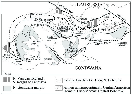
General zonation of the Medio-European Paleozoic Belt showing the place of the Massif Central and Massif Armoricain in Western Europe. Correlations with Iberia and Central Europa remain hypothetic.
The North Gondwana margin is represented by the southern part of the Massif Armoricain and the entire Massif Central (Figures. 1, 2, 3, 4). Both areas experienced the same tectonic evolution. However, in southern Brittany, the primary nappe structure characterized by a flat-lying foliation and stacked units, is obscured by subvertical faults belonging to the dextral South Armorican Shear Zone. Although important for the understanding of the bulk tectonic framework, the South Armorican Shear Zone is a late structure active in Namurian-Westphalian times as shown by the syntectonic leucogranitic plutons (Berthé et al., 1979). The estimated total offset of 50-80 km does not significantly alter the general reconstruction of the N. Gondwana Margin with respect to the Central Armorican Domain. The stacked units recognized in the Massif Central and southern Massif Armoricain are presented from bottom to top (Ledru et al., 1989; Le Corre et al., 1991; Colchen and Rolin, 2001, Faure et al., 2004 and enclosed references).
The foreland basin, along the southernmost part of the Massif Central, is a Middle Carboniferous (Visean-Namurian) turbiditic basin widely developed southward below the coastal plain of the Mediterranean Sea and up to the Pyrénées. In the Montagne Noire, proximal turbiditic facies consists of wild flysch including kilometer-scale olistoliths of Paleozoic sedimentary rocks coming from the next unit. In Vendée (southernmost part of the Massif Armoricain), crops out a Tournaisian-Visean olistostrome with Silurian radiolarian cherts and limestones but its structural setting is not well understood yet (Colchen and Poncet, 1989).
The Paleozoic Fold and Thrust Belt consists of weakly or un-metamorphosed rocks displaced to the South, as thrust sheets or kilometric-scale recumbent folds well developed in the Montagne Noire area but absent in the Massif Armoricain. The Cambrian-Ordovician rocks are unconformably overlain by terrigeneous rocks and platform carbonates of Devonian and Early Carboniferous age. Silurian rocks are almost lacking.
The Para-autochthonous Unit to the North, overthrusts the Paleozoic sedimentary series. It is formed by greenschist to lower amphibolite facies metapelites, quartzites, and a small amount of limestone and amphibolite. This Para-autochthonous Unit is widely exposed in Cévennes, Albigeois and Vendée. In the north of the Massif Central, the Para-autochthonous Unit crops out in tectonic windows surrounded by the Lower Gneiss Unit. In Cévennes and Vendée, this unit is underlain by partly migmatized orthogneiss derived from alkaline granites.
The Lower Gneiss Unit (LGU) is composed of medium pressure/medium temperature metagreywackes, metapelites and metarhyolites intruded by numerous alkaline porphyritic granitoids of Cambrian to Early Ordovician age transformed into augen orthogneiss during the tectonic-metamorphic events.
The Upper Gneiss Unit (UGU) forms the overlying nappe. It is made of rocks which experienced the higher metamorphic pressure, locally reaching coesite-eclogite facies near Lyon (Marchand, 1981; Godard, 1988; Lardeaux et al., 2001). The protoliths of the UGU, partly similar to those of the LGU, include metasediments and granitoids. Moreover, the UGU is also characterized by a bi-modal magmatic association, called the "leptynite-amphibolite complex" interpreted as formed during the rifting that led to the separation of Armorica from North Gondwana. In the Massif Central, rare Early Ordovician metagabbros and serpentinized ultramafics are considered by some authors as remnants of the Medio-European Ocean (e. g. Dubuisson et al., 1989). However, it is worth to note that ophiolitic nappes deformed and metamorphosed during the devonian D1 event (cf. belowsection 3) are not recognized in the Massif Central. Conversely, in the Baie d’Audierne, at the western end of the Massif Armoricain, metabasites (basalts, gabbro, amphibolite, eclogite), mafic volcanic-sedimentary rocks and serpentinized peridotites are considered as ophiolitic remnants of the Early Paleozoic Medio-European Ocean (Ballèvre et al., 1994). Glaucophane-garnet +/-lawsonite micaschists found in the Bois de Céné and Ile de Groix are sub-units of the Upper Gneiss Unit. Blueschists are very rare in the Massif Central. The upper part of the UGU consists of migmatites formed by the partial melting of pelitic and quartzo-feldspathic rocks. In these rocks, mafic restites are retrogressed eclogites.
The Thiviers-Payzac Unit is the highest tectonic unit of the allochthonous stack in the Massif Central. It is formed by Cambrian metagraywackes, rhyolites and quartzites. Conversely to the underlying UGU, the Thiviers-Payzac Unit never experienced the high pressure metamorphism. The allochthony of the Thiviers-Payzac Unit with the underlying UGU established on the basis of metamorphic and structural observations (e. g. Floc'h, 1983; Roig, 1997; Duguet, 2003) is also supported by seismic lines (Bitri et al., 1999). It is worth noting that this uppermost unit is lithologically and structurally similar to the Para-autochthonous Unit that crops out in the southern Massif Central (i. e. St-Sernin-sur-Rance Nappe, Guérangé-Lozes, 1987; Figure 2). In Vendée, the Thiviers-Payzac Unit is represented by graywacke, rhyolite, quartzite and siltite that form the Chantonnay syncline (Figure 3). Due to a metamorphic overprint weaker than in the Massif Central, preserved Cambrian and Silurian-Devonian fossils allow to assess the stratigraphic age of this unit (Wyns et al., 1989).
The Brévenne Unit consists of oceanic rocks (pillow basalts, diabase dykes, gabbros, ultramafics and siliceous sedimentary rocks) of Devonian age interpreted as an ophiolitic nappe (Pin et al, 1982; Sider and Ohnenstetter, 1986; Pin and Paquette, 1998) overthrust to the NW upon pre-Devonian gneiss in Latest Devonian-Early Carboniferous (Faure et al., 1997; Leloix et al., 1999). In the South Limousin, some small outcrops of gabbro, mafic metavolcanics (sometimes pillowed), radiolarian cherts, siliceous red shales and Middle Devonian limestones form the Génis Unit. The structural and paleogeographic setting of the Génis Unit is not yet settled. Although sometimes considered as an ophiolitic nappe (e. g. Ledru et al., 1989), the lack of outcrop continuity suggests that the Génis Unit might be a Late Devonian-Early Carboniferous olistostrome reworking oceanic rocks similar to those of the Brévenne Unit.
The peculiarities of the Southern Massif Armoricain. The Brévenne Unit is not recognized in the Massif Armoricain, however, the south part of this massif exhibits two specific features. Firstly, east of Nantes, the Mauges Nappe (Cogné, 1974; Figures 3, 4) consists of Neo-Proterozoic micaschists unconformably covered by Cambrian-Ordovician unmetamorphosed terrigeneous rocks and acidic lava flows (Cavet et al., 1966). The Mauges Nappe overthrusts high pressure metamorphic rocks and migmatites of the Champtoceaux complex correlated with the UGU. It is worth noting that the South part of the Massif Armoricain is the only place in the whole French Variscan Massifs where a basement nappe overlies the Upper Gneiss Unit. Secondly, north of the Loire estuary, high temperature metamorphic rocks, migmatites and granitoids form the «Cornouailles Anticline» (Cogné, 1974; Audren, 1986; Figure 4). The bulk structure of this complex area and its relationships with other units of the Massif Armoricain remain poorly understood. The boundary between the North Gondwana Margin and the Central Armorican Domain corresponds to the Nort-sur Erdre fault which is the place of the Early Paleozoic suture zone reworked by strike-slip tectonics (cf section 3).
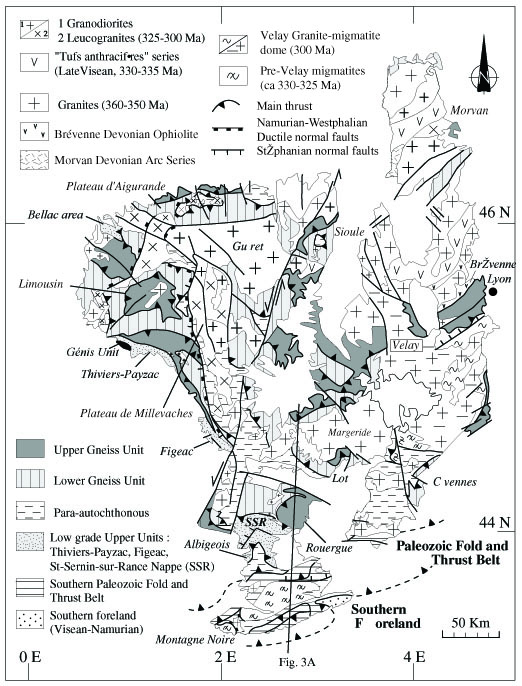
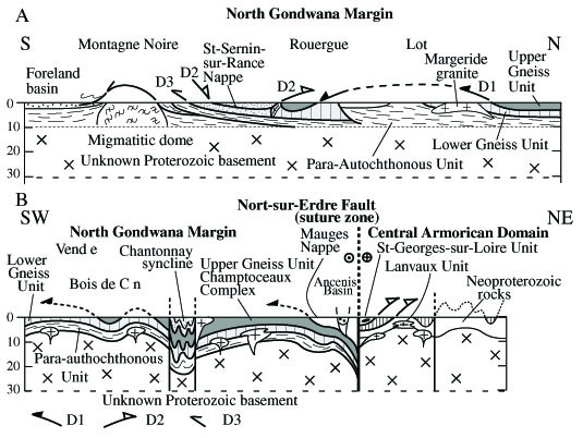
Figure 4. Structural map of the French Massif Armoricain
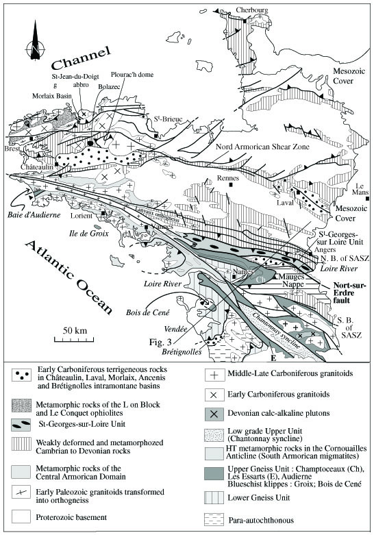
Structural map of the French Massif Armoricain (modified from Le Corre et al., 1991 and Rolet et al., 1994). Thin lines in the Upper Gneiss Unit are the main orthogneiss bodies metamorphosed under eclogite facies.
It consists of a Proterozoic basement built up during the Neo-Proterozoic (or Cadomian) orogeny, unconformably covered by a Cambrian to Early Carboniferous sedimentary cover and intruded by numerous Carboniferous plutons. The Central Armorican Domain is limited to the South, from the North Gondwana margin by the Nort-sur-Erdre fault and to the North, from the Léon Block by the Conquet suture (Figures 1, 4). To the northeast, the boundary of the Central Armorican Domain is hidden below the Channel. In agreement with Rolet et al. (1986), two sub-areas are distinguished in the Central Armorican Domain.
The eastern area, around Rennes and in Normandy, consists of a Proterozoic basement deformed and metamorphosed during the Neo-Proterozoic Cadomian orogeny unconformably overlain by a Paleozoic sedimentary cover. During the Paleozoic times, this eastern area experienced a relatively weak deformation characterized by upright folds with subvertical cleavage coeval with low to middle temperature metamorphism. These structural and metamorphic features are related to granite emplacement along the North and South Armorican Shear Zones. From the North Armorican Shear Zone to Cherbourg, the Paleozoic rocks unconformably overlying the Proterozoic basement are gently deformed by E-W to NE-SW trending south-vergent synclines coeval with basement-cover decollements (Rolet et al., 1994).
The western area, east of Brest, experienced stronger Paleozoic tectonics and metamorphism than the eastern area. Horizontal displacements and locally staurolite-kyanite-garnet metamorphism took place before the sedimentation of the Early Carboniferous Chateaulin basin (Rolet et al., 1994). As suggested by early workers (e. g. Cogné, 1974) and discussed below in section 5, this Late Devonian-Early Carboniferous event, called Bretonian phase, played an important role in the geodynamic evolution of the Central Armorican Domain.
The southern part of the Central Armorican Domain, north of the Nort-sur-Erdre fault, is formed by a peculiar unit called the St-Georges-sur-Loire Unit (Figure 3). Recent petrological, and structural works show that the St-Georges-sur-Loire Unit consists of a southern olistostrome subunit of Middle to Late Devonian age and a northern terrigeneous subunit (Cartier et al., 2001). The olistoliths are Silurian radiolarian cherts, Devonian limestones, mafic pillow lavas, gabbro and pyroclastics, Cambrian (?) rhyolites and undated grauwackes. Both sub-units are overthrust to the north upon the Lanvaux anticline formed by Cambrian-Ordovician sedimentary rocks and the Lanvaux Ordovician orthogneiss. The tectonic significance of the St-Georges-sur-Loire Unit will be discussed in section 5. In the following, the Central Armorican Domain will be considered as a part of the Armorica microcontinent which corresponds to a continental stripe drifted from Gondwana in Ordovician and rewelded to it in Late Silurian.
The Léon Domain forms the NW part of the Massif Armoricain (Figures 1, 4). In spite of numerous Carboniferous plutons partly hidding the structural relationships between the units, an antiformal stack of nappes is presently recognized (Le Corre et al., 1989; Rolet et al., 1994; Figure 5). From bottom to top, the structure of the Léon Domain consists in the following succession.
Figure 5. Structural map and cross section of the Léon Block
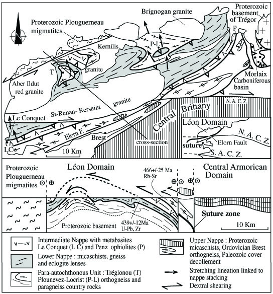
Structural map and cross section of the Léon Block (adapted from Rolet et al., 1994). For clarity, the Carboniferous granites are unpatterned in the map and not represented in the cross section.
The Para-autochthonous Unit corresponds to paragneiss intruded by augen orthogneiss (Tréglonou and Plounevez-Lochrist) which emplacement is dated at 385+/- 8 Ma by Rb-Sr method on whole rock, and 400+/-40 Ma by U-Pb method on zircon fractions (Cabanis et al., 1979). Both the augen gneiss and country rocks experienced migmatization but its age is still unknown.
The Lower Nappe is formed by biotite-garnet-sillimanite gneiss that enclose eclogitic rocks mostly retrogressed into amphibolite and derived from gabbro or basalt. Pyroxenites and serpentinites crop out locally. P-T conditions for the eclogitic metamorphism are estimated around 14-15 kbar, and 650-700°C respectively. U/Pb dates from zircons provide an age of 439+/-12 Ma which is considered as that of the high pressure metamorphism (Paquette et al., 1987).
The Intermediate Nappe or Penzé-Le Conquet ophiolitic nappe consists of ortho- and paraderived amphibolite, metagabbro, serpentinite, biotite-garnet-staurolite micaschist and metachert. These rocks which are interpreted here as remnants of an oceanic area that separated the Léon Domain and the Central Armorican Domain form Le Conquet suture (Figures 1, 4)
The Upper Nappe consists of Late Proterozoic micaschists intruded by Ordovician granodiorites, presently deformed into orthogneiss (e. g. Brest orthogneiss) dated around 466+/-25 Ma by Rb-Sr method on whole rock (Cabanis et al., 1979). Weakly deformed Ordovician white quartzite and pelite form the Paleozoic cover of the Proterozoic basement. A north directed decollement separates the Paleozoic cover from its Proterozoic basement (Figure 5).
This stack of nappes is cut by the dextral strike-slip Elorn fault which is a branch of the North Armorican Shear Zone. The main ductile deformation coeval with nappe stacking in the Léon Block is characterized by a N-S to NNW-SSE trending stretching lineation with top-to-the-N (or NW) shear criteria observed from the Para-autochthonous Unit up to the Penzé-Le Conquet Ophiolitic nappe (Figure 4). A second ductile deformation is restricted to the dextral Elorn wrench fault. The top-to-the-North shearing is presently undated, however, it is older than the emplacement of the Early Visean St-Renan-Kersaint granite (ca. 340 Ma) and younger than the Ordovician quartzite of the Upper Nappe, an Early Carboniferous age (ca. Tournaisian) is likely. The Léon Domain has been considered as the western part of the Upper Gneiss Unit of the South part of the Massif Armoricain located west of the Baie d’Audierne area and translated to the North by the Elorn strike-slip fault (e. g. Balé and Brun, 1986; Le Corre et al., 1989). Such an interpretation is not supported by available data. Near the Penzé river, at the NE termination of the Léon Domain (Figure 5) such a strike-slip fault is not recognized. Conversely, the conspicuously developped low angle, south dipping foliation and NNW-SSE lineation suggest rather that the Central Armorican Domain overthrusts the Léon Domain. Therefore, the Penzé-Le-Conquet ophiolitic nappe rooted in Le Conquet suture separates the Léon Domain from the Central Armorican Domain.