The structure of the study area (Figure 2) is dominated by mainly NW-SE trending regional folds and associated NE verging thrusts. Thrust tectonics along the Northern Apennine foothills, and in the northern Marche area in particular, is well documented by field surveys integrated with the interpretation of seismic reflection lines and deep wells carried out for hydrocarbon exploration [e.g. Mazzoli 1994; Casabianca et al. 1995; Arcaleni et al. 1996; De Donatis et al. 1996, 1998; Coward et al. 1999; De Donatis 2001; Mazzoli et al. 2001; Butler et al. 2003].
Figure 2. Geological sketch map of the northern Marche area
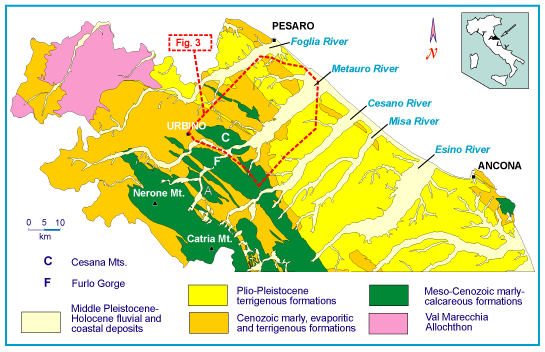
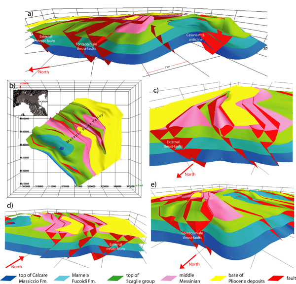
Box shows location of the 3D model of Figure 3.
Major faulted anticlines are generally sub-cylindrical [as defined by Ramsay and Huber 1987], with NW-SE oriented, sub-horizontal, mean (fold axes. However, fold sectors showing substantial distortion from the regional trend also occur (e.g. northwestern periclinal termination of the Monti della Cesana anticline; Figure 3). These areas are characterised by large (> 45°) rotations around a vertical axis, as indicated by paleomagnetic data. Significant rotational deformation has been related to the occurrence of lateral thrust tips and/or gliding and moulding on blind oblique thrust ramps [Mazzoli et al. 2001]. Thrust faults within the study area consist in fact of mostly blind, relatively short and discontinuous segments characterised by anastomosing geometries and important development of oblique and lateral ramps [Coward et al. 1999; Mazzoli et al. 2001]. The 3D structural model of the Metauro River Valley area, for instance, shows that roughly E-W trending, blind oblique ramps characterise the northern sectors of major thrust faults (Figure 3), whilst NE-SW lateral ramps occur in the off-shore sector of the study area [Coward et al. 1999].
Concerning the timing of thrust activity, the analysis of syn-depositional compressional structures related to fold growth reveals that their youngest age post-dates the early Pliocene along the Adriatic coast [e.g. De Donatis et al. 1996, 1998; Coward et al. 1999]. The geometry of syn-orogenic strata cropping out in the coastal zone between the Metauro and Cesano Rivers (Figure 2) indicates a mid-late Pliocene age for major fold growth in this area. Lower Pleistocene deposits off-shore appear to be slightly involved in the deformation associated with the frontal thrust of the Apennine chain. In contrast, the upper part of the Quaternary succession shows undeformed reflectors (including unconformities) that extend for kilometres and overlie and seal the most external thrusts of the belt [Di Bucci and Mazzoli 2002; Di Bucci et al. 2003]. These data suggest that NE directed thrusting at the front of the Northern Apennines ended in early Pleistocene times.
Within the on-shore sector of the study area, recent (i.e. post-thrusting) faults have been recognised in both pre-Quaternary substratum rocks and late-Quaternary continental deposits (upper Pleistocene terrace alluvium, upper Pleistocene-Holocene slope deposits). The surveyed faults, characterised by very low documented displacements, are all compatible with WSW-ENE oriented extension. They appear to form part of a hard-linked fault system mostly including roughly N-S trending normal faults and NE-SW striking, oblique-slip transfer faults with a left-lateral component of motion. Although most of the observed recent ruptures are clearly sealed by mid-late Pleistocene and Holocene slope-waste and alluvium, the occurrence in several sites of late Pleistocene-Holocene faulted deposits suggests that WSW-ENE oriented extension might be active at present in the study area [Savelli et al. 2002].
Within the on-shore sector, both the along-valley and vertical distribution of stream terraces provide some constraints on the age of thrusting and folding as well as on the neotectonic behaviour of such area. The major valley terraces have been categorised as strath-terraces and fill-terraces. The former (mid Pleistocene, 170-300 m above the floodplain) hint at an overall tectonic origin, the latter (mid-late Pleistocene-Holocene p.p., 30-160 m above the floodplain) result from the effects of climatic variations combined with a generalised tectonic uplift [e.g. Fanucci et al. 1996; Di Bucci et al. 2003, and references therein]. Many minor late Pleistocene - Holocene terraces resulting from a complex series of genetic factors are also recognisable [e.g. Nesci et al. 1995]. Specifically, close to the modern coast-line the latest Pleistocene - Holocene (unpublished radiocarbon dating bear out such chronological attribution) terrace-alluvium top-surfaces merge into a quite continuous strip of coast-terraces (heights from 2-3 m up to ca. 15 m).
Fluvial terraces are substantially parallel, even across the anticline ridges, thus hinting at a generalised vertical uplift and disclaiming any significant deformation by fold activity ever since the second half of middle Pleistocene [Nesci et al. 1992; Di Bucci et al. 2003; Mayer et al. 2003, and references therein]. Evidence (e.g. convex valley flanks profiles, ongoing confinement of alluvial fans) for an increasing middle-late Pleistocene valley deepening - most likely related to an enhancing vertical uplift rate - can be also pointed out [e.g. Nesci et al. 2002; Di Bucci et al. 2003 and references therein].
Although some local terrace-levels convexities underline minor (i.e. fairly less than valley down-cutting amount) differential movements [e.g. Nesci et al. 1990], their occurrence - apparently unrelated to the pattern of folds and associated thrust-faults of the area - can be associated with differential rates of vertical uplift and/or to middle-late Pleistocene normal faulting [Di Bucci et al. 2003]. A marked down-valley terrace-level convergence also occur [cf. Elmi et al. 1987; Nesci et al. 1990] in response to both strong sea-level falls shortly before each of the main middle-late Pleistocene "cold-aggradation" fluvial events and higher uplift/downcutting rates in the internal areas. As the off-shore "points of convergence" of each valley terrace-flights are placed at different distances from the modern coastline, differential neotectonic behaviours of sectors stretching in an overall NE-SW / NNW-SSE direction (c.ca perpendicular to the strike of the thrust belt) can be assessed for the northern Marche river basins [cf. Elmi et al. 1987; Dramis 1992; Fanucci et al. 1996].
If the recent faults mentioned in the previous section are taken into account, it can observed that they are seldom associated with peculiar landforms. Moreover, any specific active control of individual ruptures in the geomorphology of the study-area is not discernible even when a fault bears some geomorphologic evidence, being the only effects of differentiate erosion clearly recognisable (e.g. deep gullies actively entrenching along NE-SW oblique-slip transfer faults sealed by undeformed later-middle Pleistocene alluvium). Hence, although the geomorphologic effect of individual ruptures can be regarded as negligible or indefinable, the surface expression of the deformation produced by the recent fault system can be envisaged to have played an active role in controlling the landscape evolution of the study area [e.g. Di Bucci et al. 2003], at least in the middle Pleistocene and in the lower part of the late Pleistocene. In this respect, the marked south-eastwards (i.e. towards the right valley-sides) deflection of the northern Marche trunk rivers can be an important morphotectonic topic. In actual fact - although such long-debated behaviour is object of several different interpretations [cf. Di Bucci et al. 2003, and references therein] - the occurrence of a strong valley axis deflection towards the core of an anticline (i.e. Monti della Cesana; Borraccini et al. 2002) highlights, in the Metauro River valley, an overall control by WSW-ENE oriented structures rather than by anticline growth mechanisms [e.g. Savelli et al. 2002; Borraccini et al. 2002].
Analysis and correlation of historical and instrumental events for the Northern Apennine foothills and adjacent Adriatic indicate that this area is characterised by a moderate seismicity (epicentral maximum intensity hardly reaching a value of IX MCS), with maximum magnitudes of about 6 (Gruppo di Lavoro CPTI, 1999) and hypocentral depths generally in the first 20 km [Frepoli and Amato 1997]. Only a few instrumental events display a magnitude larger than 4.5. The related focal mechanisms show a lack of homogeneity, as they include: (i) normal fault solutions with NW-SE oriented nodal planes [Gasparini et al. 1985; Mariucci et al. 1999]; (ii) reverse fault solutions with WSW-ENE striking nodal planes [Selvaggi et al. 2001]; and (iii) strike-slip fault solutions with WNW-ESE and NNE-SSW nodal planes [Gasparini et al. 1985; Mariucci et al. 1999].
The same inhomogeneity also characterises minor seismicity which, according to Frepoli and Amato [1997], shows a predominance of thrust and strike-slip fault solutions with respect to normal fault solutions. The latter Authors also identify, for the study area, a horizontal, SW-NE oriented 1 and a steeply dipping (60°) 2, suggesting a stress regime "closer to a strike-slip than a reverse-faulting regime" [Frepoli and Amato 2000].
The area specifically analysed in the present study is characterised by a low concentration of seismic events [Santini 2000]. Recently Di Bucci et al. [2003] and Santini [2003] analysed the instrumental seismicity of the area comprised between 12.7°E and 13.2°E of longitude, and between 43.5°N and 44.0°N of latitude (therefore including the area of the present study). The latter Authors considered the events that occurred in years 1987-2000, recorded by the centralised Italian Telemetered Seismic Network (ITSN) of the Istituto Nazionale di Geofisica e Vulcanologia. Most of the 83 recorded events have magnitude < 3.0, while only a few of them show magnitude values between 3.0 and 4.1. Epicentre distribution is very scattered, and hypocentral depths are generally comprised within the first 20 km of the crust, clustering between 0 and 15 km. Focal mechanisms were obtained by Santini [2003] for the events of highest magnitude (Table I). They are mostly characterised by a sub-horizontal maximum compressional (P) axis oriented about NNW-SSE, although variations also occur (Figure 4).
Figure 4. Epicentre location and focal mechanisms
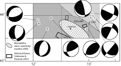
Epicentre location and focal mechanisms of seismic events listed in Table I (after Santini 2003).
Table 1. Parameters of the seismic events whose epicentres and focal mechanisms are shown in Fig. 3 (from SANTINI, 2003).
| Label | Year | Month | Day | Lat. (°N) | Long. (°E) | Depth (km) | Md | Strike | Dip | Rake |
|---|---|---|---|---|---|---|---|---|---|---|
| 1 | 1990 | August | 27 | 44.02 | 13.177 | 5.0 | 3.9 | 115° | 50° | 0° |
| 2 | 1991 | November | 22 | 43.842 | 12.062 | 5.9 | 3.0 | 165° | 60° | -70° |
| 3 | 1996 | June | 28 | 43.769 | 12.995 | 27.5 | 3.4 | 155° | 40° | 110° |
| 4 | 2000 | February | 22 | 43.79 | 12.083 | 8.0 | 3.0 | 265° | 65° | -120° |
| 5 | 2000 | May | 5 | 44.014 | 13.192 | 5.0 | 4.1 | 195° | 25° | 30° |
| 6 | 2000 | June | 25 | 43.886 | 13.147 | 5.0 | 3.5 | 130° | 90° | -50° |
| 7 | 2000 | June | 27 | 43.883 | 13.200 | 5.0 | 3.4 | 115° | 85° | 40° |
| 8 | 2000 | August | 1 | 43.929 | 12.318 | 5.0 | 4.2 | 160° | 70° | 130° |
| 9 | 2000 | December | 27 | 43.678 | 12.245 | 5.0 | 3.2 | 115° | 30° | -80° |
In synthesis, the analysed seismicity confirms the same complexity shown by minor and major seismicity at a regional scale [for a review, see Di Bucci and Mazzoli 2002, and references therein] and cannot be used to reliably constrain present-day activity or inactivity of the thrust front in the study area. Therefore, other geophysical and geological data sets need to be taken into account.