The Borborema Province of northeast Brazil (Figure 1; Almeida et al., 1981) is a ca. 450,000 km2 Brasiliano orogenic belt that formed as a result of convergence of the Amazonian, West African-São Luis and São Francisco Cratons during the assembly of West Gondwana around 600 Ma (Brito Neves and Cordani, 1991). This province is part of a larger Pan-Gondwana belt that extends farther south as the Brasília Belt and can be traced into Central Africa by means of lithologic correlations and a series of major shear zones (Figure 1; Caby, 1989; Trompette, 1994; Toteu et al., 1994). Over the past 15 years a series of U-Pb zircon and Sm-Nd whole-rock isotopic studies, and geologic studies of the Borborema Province (e.g. Hackspacher et al., 1990; Van Schmus et al., 1995; Fetter et al., 1997, 2000, 2003; Dantas et al., 1998; Silva Filho et al., 2002), have helped to define the crustal architecture of the province and have yielded important insights into its pre-collisional geologic history, and, in turn, a better understanding of the nature of West Gondwana assembly.
One aspect of this event of considerable geologic interest pertains to the collision between the West African-São Luis Craton and the Borborema Province, and the timing and duration of different tectonic phases that followed. Such information is well recorded by the rocks in the Médio Coreaú Domain (MCD), located in the northwest part of the Borborema Province (northeast Brazil). This domain is the SE extension of African Dahomeyan-Pharusian belt that borders the eastern margin of the West African-São Luiz Craton (Figure 1; Torquato & Cordani, 1981; Caby, 1989; Caby et al., 1995; Brito Neves et al., 1999). The crystalline basement of the MCD is composed of early Paleoproterozoic gneisses, migmatites and granulites, which are overlain by late Paleoproterozoic to Neoproterozoic supracrustal sequences. Syn-, late-, and post-tectonic (late Neoproterozoic to Cambrian) granitoids, generated during the Brasiliano Orogen, intrude both basement and supracrustal units. Detailed structural and microstructural studies of these rocks, coupled with precise U-Pb geochronology, provide important controls on the structural and tectonic evolution of the MCD, hence the Borborema Province, prior to and during the amalgamation of West Gondwana.
The aim of this paper is to present and discuss our structural (field), microstructural and geochronological data from key geologic units of the MCD and their implications for the tectonic development and deformational history of the NW Borborema Province. These data show that the three structural fabrics preserved by the post-Paleoproterozoic rocks of the MCD are the result of three different progressive deformational events: a) thrusting (D2); b) transcurrent movements (D3); and c) vertical uplift associated with late transpresssion (D4), all of which developed during the late Neoproterozoic Brasiliano orogeny. We will discuss the implications of this result for the regional tectonic history and present a model for the tectonic development and deformational history of the MCD.
Figure 1. Pre-Mesozoic drift reconstruction of parts of Africa and South America
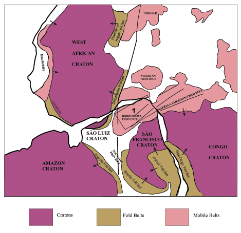
Pre-Mesozoic drift reconstruction of parts of Africa and South America showing the major cratonic and Pan-African/Brasiliano Provinces (modified from Trompette, 1994). Rectangle 1: north portion of the Borborema Province, arrows indicate sense of transport.
The geology of the Borborema Province (Figure 2) is comprised of: (1) basement gneiss and migmatite complexes; (2) deformed and metamorphosed supracrustal sequences; and (3) Brasiliano granitic plutons. Structurally, the province is cut by numerous shear zones and is divided into three major tectonic domains: the Northern, Transversal, and Southern Domains, separated by two continental-scale shear zones: the Patos and Pernambuco Lineaments (Figure 2). The Northern Tectonic Domain is located north of the Patos Lineament, the Southern Tectonic Domain is located south of the Pernambuco Lineament, and the Transversal Domain, is between the two lineaments (Van Schmus et al., 1995; Brito Neves et al., 2000). Of the three tectonic domains, the Northern Domain is the largest and has the most diverse and complex crustal architecture. Comprehensive Sm-Nd isotopic studies and U-Pb geochronology of basement lithologies in the Northern Domain have been used to identify three distinct crustal blocks: the Rio Grande do Norte, the Central Ceará, and the Médio Coreaú (or Northwest Ceará) blocks, whose limits are marked by Senador Pompeu and Transbrasiliano or Sobral Pedro II Lineaments, respectively (Figure 3).
Figure 2. General geologic map for NE Brazil
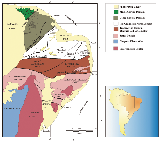
General geologic map for NE Brazil showing the major structures and crustal subdivisions of Borborema Province (redraw from Van Schmus et al., 1995).
Figure 3. Geologic map of the Northern Domain of the Borborema Province
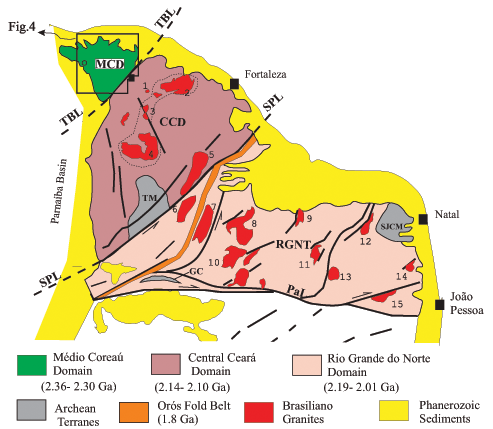
Geologic map of the Northern Domain of the Borborema Province, showing the main domains and Brasiliano granitic plutons situated at north of the Patos Lineament (PaL). TM-Tróia Massif (Archean inlier). SJCM São José de Campestre Massif (Archean inlier), TBL-Transbrasilian Lineament, SPL-Senador Pompeu Lineament, RGTN- Rio Grande do Norte Terrane, CCD-Ceará Central Domain, MCD- Médio Coreaú Domain, GC- Granjeiro Complex. Main Brasiliano plutons: 1- Serra da Barriga; 2- Itapajé; 3- Pajé; 4- Monsenhor Tabosa; 5- Quixeramobim; 6- Quixadá; 7- Banabuiú; 8- Caraúbas-Tourão; 9- São Rafael; 10- Pombal; 11- Acari; 12- Barcelona; 13- Picuí; 14- Monte das Gameleiras; and 15- Esperança. Dashed area correspond the Santa Quitéria continental magmatic arc.
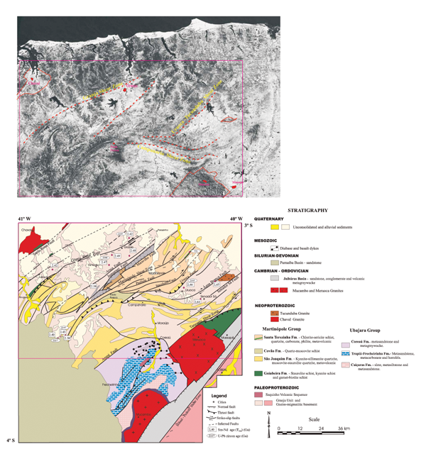
This paper focuses on the geology and tectonic evolution of the Médio Coreaú Domain in the northwest part of Ceará State (Figure 4). The crustal architecture and general geology of the other domains was summarized by Brito Neves et al. (2000), Van Schmus et al. (1995) and Fetter et al. (2000).
Figure 4. Simplified geologic map of the Médio Coreaú Domain
Simplified geologic map of the Médio Coreaú Domain, in NW portion of the Borborema Province (modified from Cavalcante & Ferreira, 1983) and similar area in the satellite LANDSAT-TM image emphasizing the main shear zones and granite plutons.