Crossing the Tethys ocean, from Europe (Monte Rosa) to Adria (Sesia-Lanzo zone)
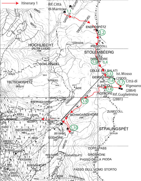
This itinerary goes from Rifugio Città di Mantova to Gressoney and then to Lillianes. It is devoted to a section across various Alpine tectonic slices, traversing the Europe plate (Monte Rosa unit), the Tethys ocean (Zermatt-Saas ophiolite), up to the Adria microplate (Sesia-Lanzo zone). It requires two days with the possibility to spend a night at Rifugio Città di Vigevano or Rifugio Guglielmina.
The first day, we will observe near Rifugio Città di Mantova the pre-Alpine Monte Rosa migmatitic basement that has been subsequently eclogitized during Alpine metamorphism. During the second day, we will follow an itinerary that starts from the Monte Rosa unit at Rifugio Guglielmina, and crosses the Zermatt-Saas ophiolite unit up to Lago Gabiet, where the upper contact of the meta-ophiolite with the Sesia-Lanzo unit can be seen. We then return to Gressoney and visit Sesia-Lanzo continental eclogitized rocks of the Adria microplate at Lillianes (Fig. 3).
Reach Rifugio Città di Mantova using cableway from Gressoney to Passo dei Salati (N 45° 52.617’; E 7° 52.069’; alt. 2936 m) or from Alagna Val Sesia to Punta Indren and then cross the Indren Glacier (an Alpine guide is highly recommended) to Rifugio Mantova. This part is recommended only for people with a good knowledge of the mountain, as it demands severe physical efforts, having to cross a glacier and to climb a hill (via ferrata). High mountain equipment is mandatory (strong boots with creepers, high-mountain clothes).
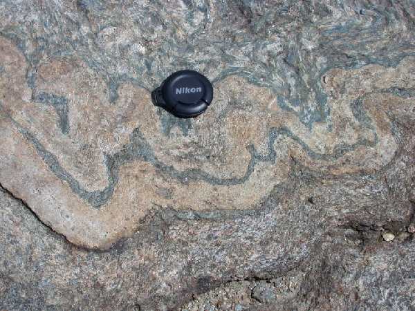
NW of the refuge, outcrops show migmatitic paragneiss with transposed leucocratic dykes. Migmatisation is obvious due to the common occurrence of leucosomes, melanosomes and nebulitic structures. In some places, migmatite encloses cm-sized dark spots that are pseudomorphs after cordierite (Fig. 4).
Figure 4. Eclogitized migmatite near Rifugio Città di Mantova

Nebulitic structures, leucosomes and melanosomes in an eclogitized migmatite near Rifugio Città di Mantova.
The black patches are pseudomorphs after cordierite. Lens cap = 3 cm.
These rocks show petrologic evidence for two distinct metamorphic stages. An early paragenesis, typical of high-T low-P conditions and coincident with migmatisation, consists of biotite + quartz + plagioclase + garnet ± cordierite ± K-feldspar + ilmenite.
During a second stage, the rocks underwent a high-P metamorphism that is indicated by several metamorphic reactions:
Biotite + plagioclase = garnet + phengite + quartz + rutile [coronas around biotite, Fig. 5, Animation 5];
Biotite = garnet + phengite + rutile [biotite pseudomorph; Fig. 6];
Ilmenite + plagioclase = garnet + rutile + quartz [coronas around ilmenite; Fig. 7, Animation 7];
Cordierite = garnet + micas + kyanite ± quartz [cordierite pseudomorph].
Figure 5. Eclogitized migmatite of Rifugio Città di Mantova
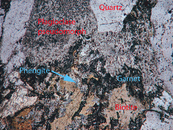
Eclogitized migmatite of Rifugio Città di Mantova: high-pressure corona between biotite and plagioclase.
Garnet grew at the expense of the pseudomorph after plagioclase and phengite occurs on the biotite side.
Figure 6. Eclogitized migmatite of Rifugio Città di Mantova
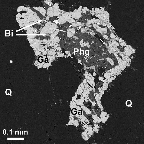
Eclogitized migmatite of Rifugio Città di Mantova: Pseudomorph after biotite.
Biotite (Bi: remnants) isolated in a matrix of quartz (Q) has been replaced by an assemblage of garnet (Ga), phengite (Phg) and rutile (white inclusions in phengite). Back-scattered electron image.
Figure 7. Eclogitized migmatite of Rifugio Città di Mantova
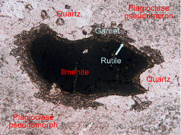
Eclogitized migmatite of Rifugio Città di Mantova: high-pressure corona between ilmenite and pseudomorph after plagioclase.
Garnet and quartz grew at the expense of the pseudomorph after plagioclase, whereas a thin rutile corona occurs on the ilmenite side. Note that the corona is interrupted at contacts with quartz. Plane-polarised light.
The coronas are occasionally visible with a lens.
These reactions, which produced garnet, rutile, phengite at the expense of biotite, ilmenite and plagioclase, are typical of a high-P eclogite-facies metamorphism. During such a metamorphism, plagioclase in metapelitic rocks is ordinarily replaced by cryptocrystalline aggregates of jadeite + quartz (+ kyanite + zoisite), which in turn are retrogressed into polycrystalline albite or oligoclase during retrogression (e.g., Tropper et al., 1999; Bruno et al., 2001). As for the Monte Rosa migmatites, the initial plagioclase was replaced by cryptocrystalline albite that contains rodlets of kyanite, zoisite and phengitic muscovite (see Plg in Fig. 6). Although jadeite has not been observed yet, it is likely that this plagioclase recrystallisation was due to the albite-to-jadeite transition followed by the reverse reaction during retrogression.
The two metamorphic stages belong to two distinct orogenic cycles, namely pre-Permian (high-T cordierite-bearing migmatites) and Alpine (eclogite-facies coronas and pseudomorphs after cordierite). This metamorphic history is characteristic of the whole Monte Rosa basement, which represents a slice of the Variscan European continental crust that has undergone subduction and subsequent eclogite-facies metamorphism during Alpine convergence.
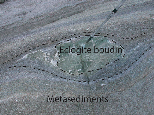
From Rifugio Città di Mantova descend down the rocky ridge made of Monte Rosa gneiss and migmatite to reach Punta Indren, after crossing the Indren glacier. Descending from Punta Indren towards Colle delle Pisse (N 45° 53.01’; E 7° 51.89’; alt. 3109 m), note the beautiful typical Monte Rosa gneiss with garnet-bearing micaschists and leucocratic gneiss. These rocks contain cm-to-m-sized boudins of a very fine-grained eclogite with blue-amphibole blasts overgrowing the fine-grained matrix. In thin section, phengite, rutile, quartz, omphacite and numerous microcrystalline atoll-shaped garnet crystals, whose core is filled with quartz or phengite, are observed. The blue amphibole (crossite and/or glaucophane) has grown lately, according to a sliding reaction (omphacite + garnet + quartz + H2O = glaucophane) that has consumed quartz and omphacite but preserved some garnet, occurring as corroded crystals in the amphibole blasts (Fig. 8, Animation 8). Surprisingly enough, these rocks are identical to the Champtoceaux and Malpica-Tuy eclogites that are known in the Variscan belt (Godard et al., 1981; Godard, 1988). As their variscan equivalent, these peculiar Monte Rosa eclogites are thought to represent pre-Variscan mafic sills of continental tholeiitic affinity (Ferrando et al., 2002; Dal Piaz, 2001) intruded in the Monte Rosa continental crust, and subsequently boudinaged and eclogitized with the latter during the Tertiary subduction. Their origin is different from that of the nearby Stolemberg eclogite (Stop 1.4) that results from eclogite-facies metamorphism of ophiolitic normal MORB (e.g., Beccaluva et al., 1984).
Figure 8. Fine-grained eclogite
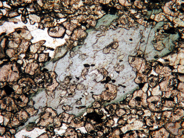
Fine-grained eclogite (garnet + omphacite + quartz), with blue-amphibole blast overgrowing the matrix and enclosing some garnet crystals.
Plane-polarised light, base of the photo corresponds to 1 mm.
From Col delle Pisse, we follow the path towards Stolemberg, crossing the contact between the Monte Rosa Gneiss and the Zermatt-Saas ophiolite of the Stolemberg peak, which is a beautiful example of a klippe of Zermatt-Saas ophiolitic metabasalts resting on the Monte Rosa basement. After the ropes along the steep path, we reach a point (N 45° 52.934; E 7° 51.874), from where we have a panorama (Fig. 9).
Looking towards the south, we see on a first plane the Corno Rosso and Lago Gabiet, which belong to the Combin ophiolitic unit, and, in the distance, a ridge with the Straling peak that belong to the overlying Sesia-Lanzo zone (Gneiss minuti). The folded contact between the Sesia-Lanzo gneiss and the meta-ophiolite is visible on the western side of the Gressoney valley, from Monte Pinter (south) to Testa Grigia and Monte Rothorn. Further north, the Combin unit occurs between Passo del Rothorn and Passo Bettaforca, where there is the tectonic contact between the Combin and Zermatt-Saas meta-ophiolites. The latter unit crops out on the southern slopes of the Monte Rosa massif. North of a line going from Monte Rosso to Lago Bleu, the Penninic gneiss occupies all the snowy peaks of the Monte Rosa.
At the base of the cliff, at about 300 m in the direction of N240, one can see the ruins of an ancient gold mine (19th-20th centuries; Lorenzini, 1998, p. 157-158). Quartz sulphide gold-bearing veins are quite abundant in the Monte Rosa massif (e.g., Curti, 1987; Lattanzi, 1990; Pettke et al., 1999), noticeably near Alagna (Val Sesia), where they have been mined for centuries. The ore is related to the mesoalpine hydrothermal activity (Stella, 1943).
Figure 9. Panoramic view from Stolemberg

Panoramic view from Stolemberg.
The ridge from M. Pinter to Testa Grigia and M. Rothorn, on the right side of the Gressoney valley, is characterized by enfolding of calcschists and prasinite (Combin meta-ophiolite) and Gneiss Minuti (Sesia-Lanzo unit). North of the M. Bettaforca, at Colle Bettaforca, the Combin meta-ophiolite is in tectonic contact with the underlying eclogite–facies Zermatt-Saas meta-ophiolite. For legend, see the previous figures. CO = Combin, SL = Sesia-Lanzo, ZS = Zermatt-Saas.
We then go downhill on the southern slope of Stolemberg and stop at the contact between the Monte Rosa gneiss and Zermatt-Saas meta-ophiolite (N 45° 52.762’; E 7° 51.936’; alt. 3068 m). Large amphibole, talc and chlorite reaction rims develop between gneiss and serpentinite (the pathway can be slippery). Meta-ophiolite of the Stolemberg mainly consists of banded albite-bearing amphibolite, with garnet relics, deriving from former eclogite. Some eclogite relics, which have escaped subsequent retrogression, consist of omphacite, garnet and amphibole.
We walk along the contact. As this one is folded, we meet different lenses of Monte Rosa gneiss and meta-ophiolite. We thus find several repetitions of the two units.
We continue downhill, and stop at a platform (N 45° 52.698’; E 7° 51.983’; alt. 3043 m), from which we can see the Stolemberg peak behind us (Fig. 10). On the slopes of the peak, we first observe typical Monte Rosa micaschists, with Alpine imprint and some white aplitic gneiss. At the platform, there occur some metabasic lenses within the Monte Rosa gneiss that displays an almost horizontal fabric (foliation 012/11).
Figure 10. Contact between Monte Rosa Basement and Zermatt-Saas ophiolite

Folded contact between Monte Rosa Basement and Zermatt-Saas ophiolite at Mt Stolemberg.
We descend to the arrival of the cableway at Colle dei Salati (N 45° 52.617’; E 7° 52.069’; alt. 2936 m). After passing in front of the arrival of the cableway, we descend a few metres and leave the path, moving some tens of metres to our right, below Corno Camoscio.
At the base of Corno Camoscio, which consists mainly of serpentinite, we can observe again the folded contact of Monte Rosa gneiss and metabasites belonging to the Zermatt-Saas ophiolite (Fig. 11). The Monte Rosa gneiss consists here of banded rocks, with leucocratic quartz+feldspar-rich layers alternating with mafic layers (5 cm thick) that are boudinaged and variously folded. Some debris of this gneiss show pseudotachylites. A few metres up, at the contact between the Monte Rosa and Zermatt-Saas units (N 45° 52.481’; E 7° 52.136’; alt. 2952 m), we observe garnet + chloritoid micaschists and abundant tremolitite. This latter rock is typical, together with chloritite and tremolite + talc + epidote ± garnet rocks, of the reaction rims that developed between micaschists (or gneiss) and serpentinite. Further uphill, one can see the mylonitic gabbro and serpentinite of Corno Camoscio.
Figure 11. Stolemberg-Col d’Olen section

Stolemberg-Col d’Olen section.
The south-dipping tectonic contact between the Monte Rosa basement and the Zermatt-Saas meta-ophiolite is represented. The Monte Rosa-Zermatt Saas enfolding is not evidenced. Legend: MR= Monte Rosa, ZS= Zermatt-Saas, Co= Combin, e= eclogite, g= metagabbro, c= calcschists, s= serpentinite. After Gosso et al., 1979.
Where the pathway passes near Istituto Mosso, leave the way to reach an outcrop, a few metres on the left (N 45° 52.469’; E 7° 52.308’; alt. 2902 m). A 2-m-high section (Fig. 12) shows typical Monte Rosa gneiss, consisting of 3-to-20-cm-thick alternating layers of quartz+feldspar-enriched rocks (leucosome) and mica-rich rocks (former melanosome). Note the large garnet crystals (up to 2 cm in diameter) that are wrapped in the pre-Alpine foliation and the disharmony of folds, due to the contrasted behaviour of the various layers. On the right, a boudin (1x3 m) of metabasite is folded within gneiss.
Inaugurated by Queen Margherita in 1907, managed by the Torino University, the Istituto Mosso was devoted to scientific researches in the fields of physiology at high altitudes, meteorology, glaciology and geology. It was recently completely destroyed by a fire, but is now under reconstruction.
Figure 12. Alternating layers of leucosome melanosome
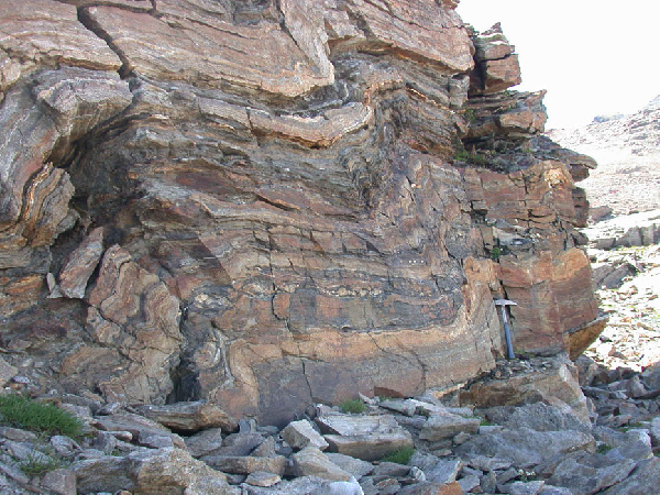
Alternating layers of quartz+feldspar-enriched rocks (leucosome) and mica-rich rocks (melanosome) near Istituto Mosso.
Axes of the asymmetric folds are oriented.
Return on the pathway that leads to Rifugio Città di Vigevano. A few tens of metres north of the refuge, serpentinite of the Zermatt-Saas unit is visible near a small lake. Looking towards Corno Camoscio, a 3-m-high ridge is visible (N 45° 52.321’; E 7° 52.371’; alt. 2861 m). It is mainly made of foliated serpentinite and shows a 50-cm-thick dyke of metabasite, slightly rodingitised, and consisting of dark-green amphibole, Ca-rich garnet and epidote. The dyke is almost horizontal and slightly foliated and boudinaged. A 2-cm-thick rim of chloritite occurs between the dyke and the enclosing serpentinite (Fig. 13). The latter displays common brownish rounded spots that were preferentially dissolved by weathering and are made of carbonates.
Around the refuge, we can observe again the main lithologies of the Zermatt-Saas and Monte Rosa units. The Monte Rosa garnet-bearing micaschists, with chloritoid ± kyanite, are folded by isoclinal folds.
We reach Rifugio Città di Vigevano (N 45° 52.251’; E 7° 52.413’; alt. 2865 m), built in 1914 and the nearby Rifugio Guglielmina, built in 1878 (N 45° 52.235’; E 7° 52.353’; alt. 2869 m). The mountains that can be seen to the east of the refuges, on the other side of the Sesia valley (Monte Tagliaferro, Cima Carnera, Cima delle Croci), show a jagged profile due to regional foliation and faults. They belong to the Combin ophiolite (Tagliaferro) and overlying Sesia-Lanzo unit (Gneiss minuti and II Dioritico-kinzigitico klippen).
Figure 13. Rodingitised metabasite
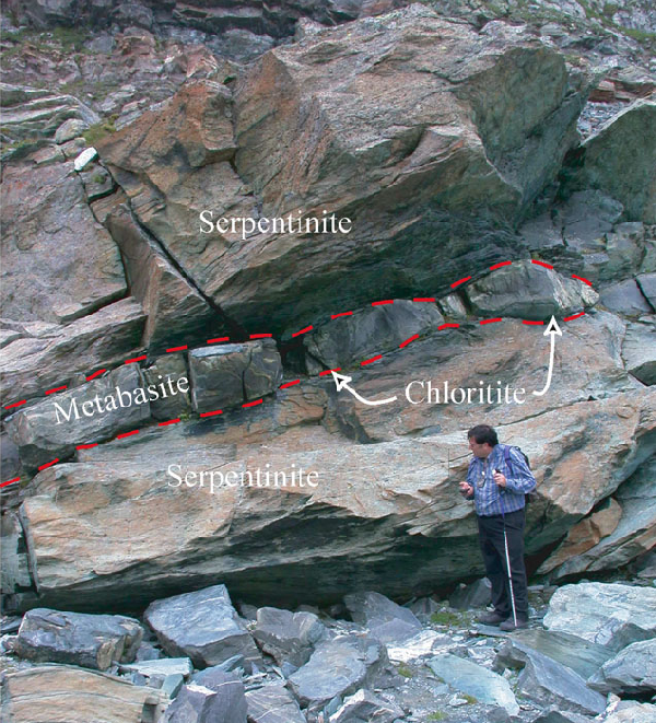
A 50 cm-thick dyke of a slightly rodingitised metabasite in foliated serpentinite (Zermatt-Saas meta-ophiolite).
We take the path that goes up to the Col d’Olen (N 45° 52.229’; E 7° 52.129’; alt. 2885 m), which is located at the tectonic contact between the retrograded greenschist-facies metabasites and serpentinite of the Zermatt-Saas unit, on the right (i.e., Corno Camoscio to the north), and serpentinites of the Combin unit., on the left (i.e., Corno Rosso to the south). The contact is outlined by cataclastic and folded calcschists with prasinite bands and thin quartzites. Although irregular, the contact dips towards SSE at an angle of about 25°.
Following the ridge a few metres southwards, we can give a look to the calcschists. Some layers contain large garnet porphyroclasts (up to 2 cm in diameter) and chloritoid (Fig.14). A little further on the ridge, lenses of listvenite (altered carbonate-bearing serpentinite) are observed in the calcschists.
Figure 14. Large garnet porphyroclasts
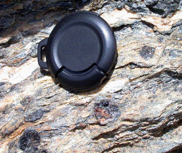
Large garnet porphyroclasts in garnet-chloritoid-bearing “calcschists” at Col d’Olen.
Lens cap diameter is 3 cm.
Descending the path from Col d’Olen, we observe rather complex associations of serpentinite, tremolitite, calcschists and rodingite of the Zermatt-Saas unit.
The pathway crosses a ski run, and, close to the cableway, reaches a sliced recumbent fold of the Monte Rosa pre-Triassic basement inside meta-ophiolite. Here, the basement is made of garnet-bearing micaschists with boudins of eclogite and albite-bearing amphibolite (N 45° 52.272’; E 7° 57.272’; alt. 2798 m). It may be attributed to the Furgg zone (see “Monte Rosa unit” in the “Regional geologic setting” section), which occurs along the Cima Indren – Gabiet section (Gosso et al., 1979). The contact between the Zermatt-Saas meta-ophiolite and the Monte Rosa unit is again very irregular, being deformed by the same post-nappe F2 and F3 folds observed near Col d’Olen.
On the way down to Gabiet, we cross again the same calcschists level observed at Col d’Olen. Looking back to the north, we can see, at the base of Corno Camoscio, the folded contact between the Zermatt-Saas greenish meta-basalts and serpentinites (above) and the light-brownish Monte Rosa basement (below). To the east, the Corno Rosso is made of serpentinite capped by thin alternances of calcschists and tabular prasinite, all belonging to the Combin unit.
We arrive at Lago Gabiet created by a dam (2367 m). From here, beautiful panoramic views (Fig. 15) allow us to summarise what we have seen and to add some regional perspective. From bottom to top, we see:
(i) The Combin meta-ophiolite, made of bands of calcschists, prasinite, metagabbro and serpentinite, crop all around the Lago Gabiet.
(ii) The contact between the Combin meta-ophiolite (below) and the Sesia-Lanzo unit (above) passes along the slopes of Punta Straling and Corno Grosso. It is evidenced by morphology and a contrast of colours. Near Punta Starling, this contact is deformed by a large-scale south-verging fold and, at Corno Rosso, it dips gently southwards.
(iii) Above, we recognise the albitic banded orthogneiss (Gneiss minuti auct.) of the Sesia-Lanzo zone (Adria continental crust, Austroalpine domain).
We can either take the cableway at Gabiet towards Gressoney or follow the small path along the Mos valley, where serpentinite and retrogressed eclogite (near the Mos house) of the Zermatt-Saas unit crop out.
Figure 15. Panoramic view towards Lago Gabiet
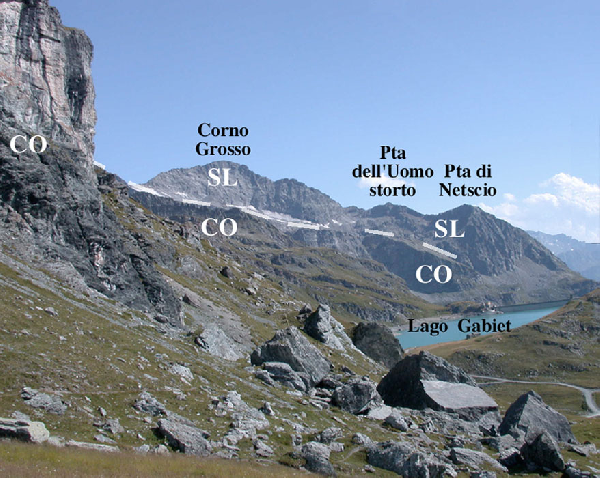
Panoramic view towards Lago Gabiet.
Lago Gabiet rests on the Zermatt-Saas meta-ophiolite, whereas the peaks in the back are in the Sesia-Lanzo zone. The ridge between the lake and the peaks is made of calcschists and serpentinite. CO= Combin; SL= Sesia-Lanzo.
From Gressoney, we drive southwards along the Val di Gressoney, for about 30 km. After 6 km, near Chemonal (Gressoney-Saint-Jean), we cross the tectonic contact between the Piedmont nappe (Combin meta-ophiolite with dominant calcschists) and the Sesia-Lanzo zone (Gneiss minuti unit, orthogneiss without eclogite-facies relics). At Issime, 14 km south of Gressoney-Saint-Jean, we enter in the inner part of the Sesia-Lanzo zone that is characterized by a well-preserved eclogite-facies imprint (Micascisti eclogitici unit). We stop a few km further to the south, at Lillianes, to observe this high-pressure unit in the Lys river.
Here, we cross the arched medieval stone bridge, over the Lys River. We descend on the western riverbank to observe rocks of the Sesia-Lanzo unit (note the large erratic block consisting of beautiful eclogite-facies micaschists with cm-sized garnet crystals). Some metres down from the bridge, an outcrop (Fig. 16) displays a whole range of eclogite-facies rocks (micaschists, gneiss, leucocratic dykes and eclogite) boudinaged and deformed together (i.e., the Micascisti eclogitici unit). These rocks show a polyphase metamorphic evolution, with a pre-Alpine high-grade evolution typical of a continental crust, followed by the Alpine eclogite-facies imprint.
Several late-Alpine undeformed dykes of a dark ultrapotassic lamprophyre (Venturelli et al., 1984) crosscut the high-pressure fabric (Fig. 16 and Fig. 17). In the Western Alps, such post-metamorphic intrusions crosscut the Alpine nappe pile (Dal Piaz et al., 1979b). They display Late Oligocene age (Venturelli et al., 1984; Pettke et al., 1999), and were probably generated by partial melting of a metasomatised mantle, with some contamination by the Alpine crust (Dal Piaz et al., 1979b; Venturelli et al., 1984). Moreover, we can see in the river bed some huge loose blocks of eclogite that come from the Zermatt-Saas ophiolite.
Figure 16. Eclogite-facies Sesia-Lanzo rocks at Lillianes
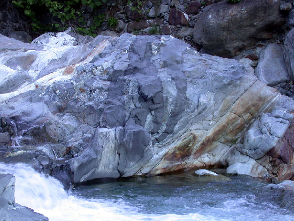
Eclogite-facies Sesia-Lanzo rocks at Lillianes.
Note the dark lamprophyre dikes that crosscut all structures.
Figure 17. Contact between Micascisti eclogitici and lamprophyric dyke
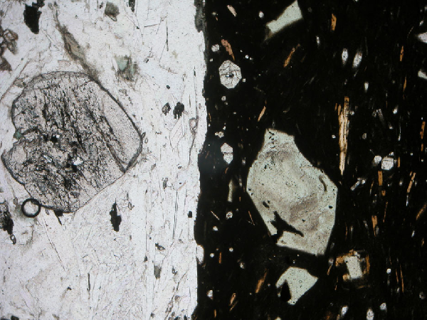
Microphotograph of the contact between Micascisti eclogitici (on the left, note garnet) and lamprophyric dyke (note pyroxene and biotite phenocrysts).
Plane polarised light, width of the photograph = 3 mm.
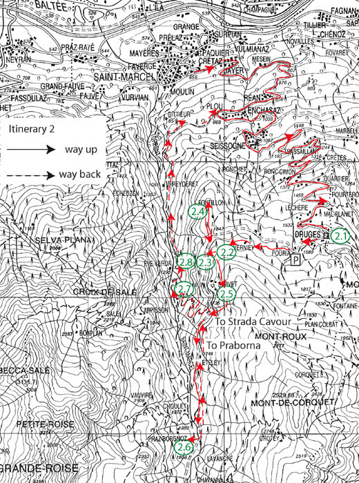
Along this itinerary (Fig.18), we visit the eclogitized oceanic deposits of Saint-Marcel, namely the Fe-Cu hydrothermal sulphide deposit of Servette and the famous Praborna Mn mine, which allow the observation of peculiar high-pressure lithologies and minerals. As these mines, now abandoned, have been exploited since the 17th century (Praborna) and, even, the Roman time (Servette), archaeological and historical aspects will also be considered (ruins, old foundry and slags). Furthermore, the trip reproduces the one followed by Horace-Bénedict de Saussure on the 20th August 1792 (Voyages dans les Alpes, t. 4, pp. 454-460), on the occasion of which he described blueschists (“schorl bleuâtre”) for the first time.
We go to Druges (Saint-Marcel), where we stop for a panoramic view (Fig. 19).
Spectacular view on, from east to west, Monte Rosa (Penninic "nappe"), Cervino/Matterhorn (Dent Blanche Austroalpine nappe), Grandes Jorasses and Mont Blanc (Helvetic nappe). Lower, on the northern side of the Aosta valley, we observe the eclogite- and blueschist-facies ophiolites of the Piedmont nappe and slices of continental crust attributed to the Adria margin (Châtillon, Pillonet and Mont Mary).
Figure 19. Panoramic view from the road at Druges

Panoramic view from the road at Druges looking towards the North. Mountains and localities names are in white. In black the different units: DB = Dent Blanche; CO = Combin greenschist ophiolite; ZS = Zermatt-Saas eclogitized ophiolite; MRU = Monte Rosa Unit.
We reach Druges Hautes, where we leave the car, and have a 30-mn walk, up to the ruins of the old foundry of Treves. Similar blast furnaces are known since the 15th century. They were designated to produce iron, which therefore should have been here a by-product of the nearby copper Servette mine.
The Treves blast furnace (Fig. 20) was loaded by the top, through a path coming from the Servette mine (see the pillars that supported the catwalk). Layers of mineralised stones and carbon, used as combustible, were interlayered in the furnace. The process produced gas, iron-rich silicate slags and iron.
Figure 20. Remains of the old foundry at Treves
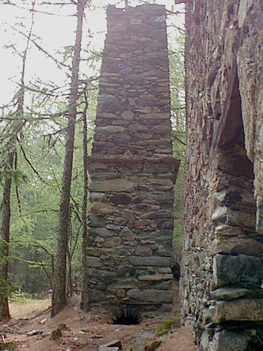
Remains of the old foundry at Treves: a furnace structure.
Near the foundry, on the southern side of the main road, we can observe huge amounts of slags (Fig. 21) deriving from the processing of Servette ore.
Two main kinds of slags are observed (Tumiati et al., 2005). Some are porous, contain fragments of gangue and pieces of carbonised wood. The more abundant slags, however, have the aspect of lava. They display an upper face with fluidal structures, internal flow channels, and a lower face with some asperities (soil imprint).
Figure 21. Huge slag cumulus
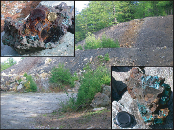
Huge slag cumulus on the path between Treves foundry and Servette mine.
In the insets, slags with fragments of charcoal (used for dating).
The slags are mainly composed of fayalite, wustite, spinel, relict sulphides and interstitial glass (Fig. 22) that concentrated residual elements such as Ca, K, Na. Late weathering has produced green crusts of Cu sulphates (Tumiati et al., 2005).
A preliminary dating of a piece of carbonised wood (Picea excelsa) enclosed in a slag provided an age of 1120±40 BP (GX-29281; Mambretti, 2003). This indicates that the mine was active during the Middle Ages, far before the activity of the Treves foundry.
Figure 22. Piece of slag from the ancient Servette mine
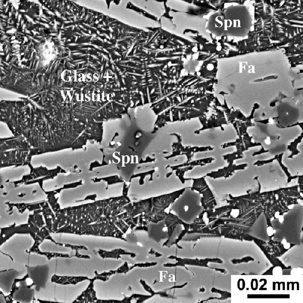
Piece of slag from the ancient Servette mine.
Spinel (Spn) and skeletal fayalite (Fa) grew in a liquid matrix, now made of glass (black) and skeletal wustite (grey). The small white grains are sulphides of Cu and/or Fe, which indicate an incomplete oxidation. Back-scattered electron image.
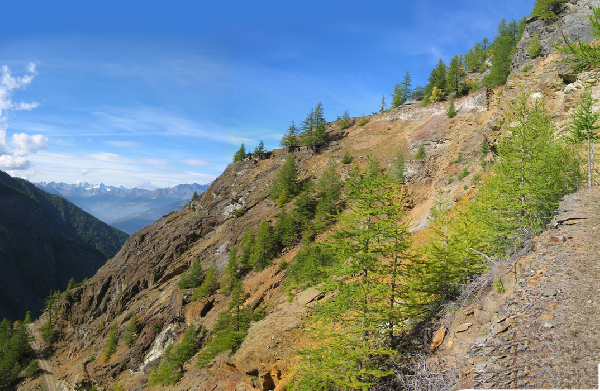
In front of the slag deposit, cross the road and go straight (i.e., to the north) into the woods. After a 5-mn walk, climb on the Fontillon ridge. The rocks consist of banded garnet glaucophanite, with lawsonite pseudomorphs, cm-thick green veins of Na-clinopyroxene, N-S-trending decimetre-thick bands of glaucophane-bearing eclogite and chloriteschists. This latter rock has been exploited, likely during the Middle Ages, for millstone manufacturing. Traces of this activity are visible at the northern extremity of the eastern wall of the ridge (very difficult access).
A viewpoint towards the Saint-Marcel river and the Monte Emilius (N 45° 42.480’; E 7° 27.239’, alt. 1642 m) allows to observe the N-dipping contact between the meta-ophiolite (greenish) and the overlying Austroalpine gneiss (brownish) of the Monte Emilius klippe (intermediate continental slice). Mylonitic serpentinite occurs along this contact.
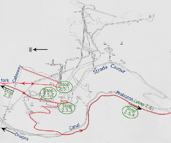
We go back to the slag cumulus (stop 2.3), leave the main road and take a pathway that climbs southwards in the woods towards the ancient mine of Servette. Along the path, some outcrops of magnetite-bearing serpentinite can be observed. At a fork, take the left branch of the way that leads to the uppermost level of the Servette mine, which was dug in sulphide-bearing meta-ophiolite.
The Saint-Marcel eclogite-facies meta-ophiolite, making part of the Zermatt-Saas unit, are overthrust by the Monte Emilius klippe (see “the intermediate continental slices” in section 2.3). The uppermost section of this meta-ophiolite, well exposed at Servette, consists of interlayered chloriteschists, talcschists, glaucophanite, quartzite, slices of eclogite-facies metagabbro and serpentinite (Fig. 23).
At Servette, these rocks include a Cu-Fe sulphide ore, consisting mainly of pyrite and chalcopyrite. The deposit occurs between 1717 and 1890 m of altitude. It is concentrated in two major ENE-dipping layers of 3-4 m in thickness, and some minor levels (less than 1 m) located at the boundary between chloriteschists and glaucophanite, but is also disseminated in the surrounding rocks.
Figure 23. Lithological map of the lower St Marcel valley
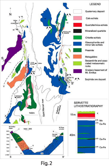
Lithological map of the lower St Marcel valley with a schematic geological section (s) and lithostratigraphy of the Servette deposit (after Martin et al., 2005).
The Servette mine was exploited during the ancient times, probably in the Middle Ages, as testified by the slag dating (1120±40 BP: see stop 2.3) and the existence of old excavations (see stop 2.5.2 below). During the 18th century, the Challant family exploited Servette, as recorded by Nicolis de Robilant (1786-87). However, most of the remnants date actually from the last period of exploitation (1854-1950; see Lorenzini, 1998).
The lithologies have been described in detail by Krutow-Mozgawa (1988), Martin and Tartarotti (1989) and Martin et al. (2005), whose works can be summarised as follows:
(a) Chloriteschists have chlorite, garnet, quartz, ±talc, ±chloritoid, ±crossite, ±paragonite and accessory sulphides, rutile, epidote, ilmenite, all aligned along the main foliation. These rocks display S1 planes (schistosity) and C-planes (shear planes), outlined by large flakes of primary chlorite, and which intersect each other at about 35°. The C-planes coincide with the main foliation of the associated glaucophanite. Garnet occurs as zoned euhedral porphyroclasts up to 1 cm in diameter, with inclusion trails (ilmenite, apatite and epidote) occurring in the core, whereas rare inclusions of rutile, crossite and chloritoid are observed in the rim. Chloritoid forms cm-sized porphyroclasts elongated along the schistosity and stretched grains along the C-planes. It is often replaced by secondary chlorite. Rare blue amphibole (crossite) crystals show rims of blue-green secondary hornblende (barroisite).
(b) In talcschists (Fig. 24), cm-sized zoned garnet crystals, characterized by pink core and red rim, and large, dark, chloritoid porphyroclasts up to 5 cm long are immersed in a fine-grained talc matrix. Only rutile and quartz occur as inclusions in garnet cores, whereas chloritoid and talc also occur in rims. Garnet, glaucophane, chloritoid, rutile and sulphides are irregularly disseminated in the matrix. Chloritoid shows chlorite + paragonite rims that are due to a retrograde reaction such as chloritoid + glaucophane = chlorite + paragonite. Glaucophane is rare and not retrograded.
(c) Glaucophanite (Fig. 25) is composed of glaucophane, garnet, chloritoid, epidote, paragonite and accessory phengite, rutile, magnetite and ilmenite. Glaucophane is strongly aligned in the main foliation and is microboudinaged parallel to the N-S trending lineation. Talc + magnetite ± albite and paragonite aggregates fill the stretching-related fractures and glaucophane is rimmed by blue-green secondary hornblende. Garnet crystals show different sizes. The biggest, up to 5 mm in diameter, are zoned with core enclosing quartz and titanite. The inner rims include rutile, quartz, chloritoid, pseudomorphs after lawsonite, ilmenite and glaucophane elongated accordingly to the outside main foliation. In the outermost rims, which grew after the external foliation, inclusions are rare, as in the smaller unzoned garnet crystals of the matrix. Prisms with a lozenge-shaped basal section are frequent in this rock. They consist of zoisite, and/or clinozoisite, paragonite, ±calcite, albite and chlorite, and are interpreted as pseudomorphs after lawsonite.
Glaucophanite in contact with talcschists is generally characterized by absence of lawsonite, abundance of glaucophane and small garnet crystals, whereas the associated talcschists have abundant talc and large garnets. In these transitional rocks, chloritoid may reach 3-4 cm in length, and is generally inclusion-free.
(d) Sulphide-bearing quartzite (Fig.26) forms thin layers. Pyrite, chalcopyrite, magnetite, garnet, cummingtonite and blue amphibole (crossite) are the major minerals besides quartz (Martin and Tartarotti, 1989; Tartarotti and Caucia, 1993). Deerite, a rare high-pressure iron silicate ((Fe, Mn)6 (Fe, Al)3 Si6O20 (OH)5), is also found aligned along the main foliation. Sulphides may include silicates, but garnet in turn includes sulphides, cummingtonite and crossite.
(e) The ore assemblages, hosted by glaucophanite, chloriteschists, talcschists and quartzite, consist of sulphides and oxides: pyrite (FeS2), chalcopyrite (CuFeS2) with minor sphalerite (ZnS2), bornite (Cu5FeS4), other secondary sulphides such us digenite (Cu9S5), pyrrotine, marcassite, mackinawite ((Fe,Ni)9 S8) (Natale, 1969; Gruppo ofiolite, 1977; Castello, 1979; Castello et al., 1980), native copper (Jervis, 1873), rutile, ilmenite, hematite and magnetite. Chalcopyrite generally defines “flames” in pyrite, or it borders earlier pyrite suggesting exsolution. Occasionally, earlier pyrite has been observed inside ilmenite. Chalcopyrite and sphalerite may crystallise later as interstitial phases and fill fractures of garnet. Bornite has been observed only as small crystals inside pyrite. Ilmenite is observed both in the main foliation and in cores and rims of zoned garnet crystals. It includes rutile and exsolved ilmeno-hematite, which were generated after the eclogite peak. In the matrix, ilmenite may show hematite rims.
(f) In the walls of the house of stop 2.5.3, a beautiful Cr- and Mg-rich light-coloured flaser eclogite-facies metagabbro shows cm-sized garnet porphyroclasts and large green Cr-rich omphacite.
(g) Micaschists and calcschists are interlayered rocks. The former may contain garnet and chloritoid, whereas the latter contain glaucophane and pseudomorphs after lawsonite.
The interlayering of glaucophanite, chloriteschists and talcschists has been interpreted as resulting from hydrothermal oceanic alteration and deformation under high-pressure metamorphic conditions of quartz-rich sediments, mafic and ultramafic materials (Martin and Tartarotti, 1989; Martin et al., 2005).
The metamorphic evolution of the Servette rocks can be summarised as follows (Martin et al., 2005). In quartzite, the presence of deerite and that of cummingtonite and crossite included in garnet evidence the early prograde evolution. In glaucophanite, this evolution is revealed by pseudomorphs after lawsonite and some relics of an early mineral assemblage preserved in garnet cores as inclusions of chlorite, lawsonite pseudomorphs, glaucophane, paragonite and chloritoid.
The main paragenesis in glaucophanite is characterised by the equilibrium assemblage garnet + chlorite + glaucophane + paragonite + talc. Martin et al. (2005) have estimated the peak metamorphic P-T conditions for the main 3 different rocks (glaucophanite, chloriteschists and talcschists), as 550 ± 60°C and 2.0 ± 0.3 GPa.
Finally, greenschist-facies partial retrogression is testified by several observations: garnet is partially substituted by chlorite and quartz; chlorite and paragonite replace chloritoid and glaucophane.
Advance along a path across the debris (Fig. 27), up to a platform where the path is interrupted (N 45° 42.054’; E 7° 27.319’, alt. 1828 m). All the rocks and ore described above are visible along the path, occurring mainly as loose blocs in the mine debris. Then, go a few steps eastwards to the entrance of the uppermost gallery (N 45° 42.059’; E 7° 27.339’, alt. 1829 m). The gallery was opened in glaucophanite and Mn-rich quartzite cm-to-dm-thick layers that grade into carbonate-rich micaschists. This Mn-bearing rock is rich in alurgite (pink Mn-muscovite), yellow Mn-garnet, red piemontite or/and Mn-epidotes. The main schistosity dips 20-30° towards ENE. Above the entrance (N 45° 42.061’; E 7° 27.338’), a rodingite (grossular-rich garnet + diopside + epidote: Fig. 28) formed by metasomatism at the expense of a metagabbro, at the contact with an overlying serpentinite slice. This one separates the Servette sequence from the overlying Mont Roux rock complex, which is made of retrogressed metagabbro, prasinite and minor serpentinite.
At the northern extremity of the uppermost level of the mine (N 45° 42.112’; E 7° 27.361’; 1820 m), one can see what was the upper terminal of the cableway towards the Chuc mine village and factory (see stop 2.7).
Figure 24. Talcschists
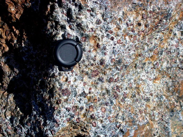
Servette talcschists with large zoned garnet crystals and prismatic chloritoid.
Note that small glaucophane prisms are found with talc in the matrix. Lens cap is 3 cm.
Figure 25. Glaucophanite
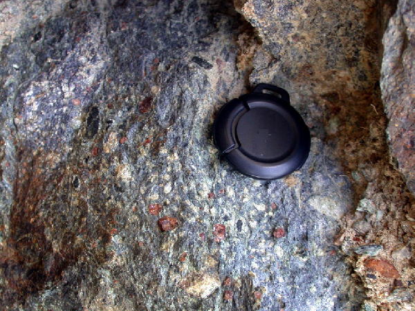
Servette glaucophanite.
Note lozenge-shaped pseudomorphs after lawsonite, cm-sized red garnet and prismatic black chloritoid crystals. Lens cap: 3 cm
Figure 26. Mineralised quartzite
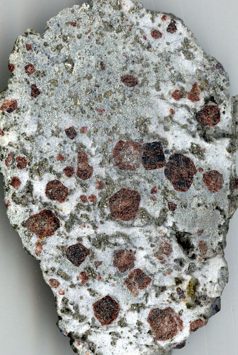
Servette mineralised quartzite.
Note cm-sized garnet crystals and abundant sulphides (pyrite and chalcopyrite).
Figure 28. Servette rodingite
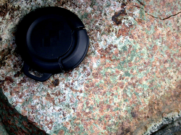
Servette rodingite in the surroundings of stop 2.5.1.
Note red grossular-rich garnets and green diopside + epidote. Lens cap: 3 cm.
Return to the fork (Fig. 27) and take the right descending branch of the path, which leads to a 7-8m long cleft opened in the wall but partly hidden by debris. This cavity results from the excavation of a sulphide-rich layer. Because of the old-fashioned technique used, which has preserved part of the ore as pillars, Nicolis de Robilant (1786-87) and several authors after him attributed this excavation to the Roman and even pre-Roman (i.e., Celtic) times, without much proof (Fig. 29).
Figure 29. Map and section of Servette mine
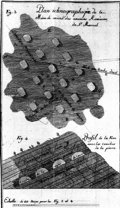
Map and section of Servette mine after the work of Robilant (1786-87).
“Fig. 3 – Map plan of the copper mine of ancient Romans in St. Marcel”; “Fig. 4 – Profile of the cave with the beds of the stone”.
Continue a few metres southwards up to the ruins (Fig. 27). The Servette mine was mainly exploited during the 18th century and in the period 1854-1950 (Lorenzini, 1998). The ruined house of the mine dates from the last period of exploitation (1854-1950). On the walls of the house, we can see a good summary of all Servette lithologies (see Stops 2.5, Introduction; Fig. 24, Fig. 25, Fig. 26). Below the mine house, several remnants of the exploitation are still visible: powder magazine, gallery entrances, tailings (Lorenzini, 1998; Zinetti, 2002).
We continue down to the main road towards the South, in direction of Praborna (Fig. 27). At the intersection with the “Strada Cavour” (N 45° 41.811’; E 7° 27.252’; alt. 1738 m), an overview of the Servette mine is visible to the north (Fig. 30). A few metres southwards, a large heap of slags is visible on the western side of the path (N 45° 41.660’; E 7° 27.134’; alt. 1734 m). These slags are porous, irregular, contain pieces of carbonised wood, which have given a recent age (<100 B.P.; GX-29282: Mambretti, 2003). They date from the last period of exploitation of the Servette mine.
Continue southwards. Where the pathway crosses the Saint-Marcel River, turn to the right in direction of the cliff. Huge and large loose blocks of manganiferous quartzite, serpentinite and metagabbro occur at the foot of the hill. They were thrown from the ancient mine, which was excavated in the cliff at about 50 m above the meadow.
The ancient Praborna mine (Fig. 31) is one of the most famous Mn occurrence worldwide. It is known since 1415 (Pelloux, 1913), and was intensively exploited by the Challant and Davise families during the 17th and 18th centuries (archives of the Aosta province, Aosta; “fonds Challant”). Braunite was used by the glassmakers of Murano, near Venice, to fade glass, thanks to the relatively high electronegativity of Mn:
Mn3+ + Fe2+ (coloured) = Mn2+ + Fe3+ (transparent).
The ore consists of manganic quartzite, including a 4-8m-thick boudinaged layer rich in braunite (Mn2+Mn3+6SiO12). It is associated with ophiolite metamorphosed in eclogite facies. Serpentinite and metagabbros overlie the Mn ore, whereas sulphide-bearing glaucophanite, chloriteschists and micaschists underlie it.
The Praborna ore is well known for its peculiar mineralogy. It is the type locality for several rare Mn minerals: violan, a semiprecious violet-blue Mn-bearing clinopyroxene (Breithaupt, 1838; Descloizeaux, 1862-74; Bondi et al., 1978; Brown et al., 1978); piemontite (Fig. 32), the manganic epidote (Napione, 1788-89; Kenngott, 1853); alurgite, the Mn-bearing variety of muscovite (Penfield, 1893); romeite, a complex oxide of Sb, Mn and Fe (Damour, 1841; Pelloux, 1913; Brugger et al., 1997); greenovite, a variety of titanite (Dufrenoy, 1840); strontiomelane (Meisser et al., 1999). Many other manganese minerals have been observed: braunite (Mn2+Mn3+6SiO12); garnets (spessartine, blythite, calderite, etc.: Martin-Vernizzi, 1982; Abs-Wurmbach et al., 1983); Mn-bearing augite, jadeite and chloromelanite; rhodonite (Mn2+2Si2O6); K-F-Mn-richterite (Martin-Vernizzi, 1982); thulite (an Mn2+ epidote); hollandite; rhodochrosite (MnCO3); etc.
Figure 32. Praborna: piemontite crystals in quartzite
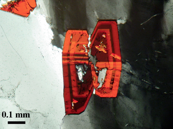
Praborna: piemontite crystals in quartzite.
The zoned piemontite displays mechanical twins that have a particular relationship with the subgrains of the host quartz. Cross-polarised light.
Although the ore is strongly banded and displays numerous and various layers that alternate at different scales (Fig. 32), a type sequence has been defined (Martin-Vernizzi, 1982; Kienast and Martin, 1983; Martin and Kienast, 1987), namely (from bottom to top): micaschists; alurgite+braunite+piemontite-bearing aegyrine-jadeitite; the braunite+piemontite-rich quartzite (Fig. 33) that was exploited; an irregular dm-thick level of Cr+Fe3+-clinopyroxene+garnet-rich quartzite, where gold was found (Fig. 34); garnet+hematite-bearing quartzite (Fig. 35, Animation 35); garnet-bearing clinopyroxenite; chloriteschists; prasinite. The sequence reflects a decrease in Mn valency (i.e., a decrease of O activity) from the braunite-rich layer of the core towards the silicate-rich levels of the boundary (Martin and Kienast, 1987). It can be interpreted in terms of diffusion fronts from core to rim (Mn, Fe, and O) and from rim to core (Na, Ca, Al…).
Figure 33. Piemontite- and braunite-rich quartzites
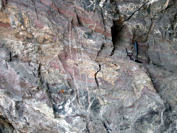
Praborna: boudinaged bands of piemontite-rich (reddish) and braunite-rich (black) quartzites.
Figure 34. Clinopyroxene+garnet-rich quartzite band
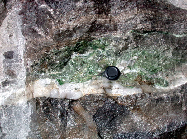
Praborna: Cr+Fe3+-clinopyroxene+garnet-rich quartzite band in braunite rich quartzite.
Figure 35. Garnet-bearing Mn-rich quartzite
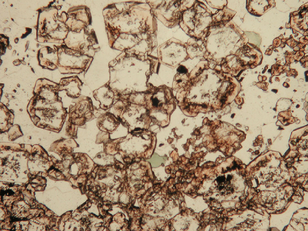
Praborna: garnet-bearing Mn-rich quartzite.
Garnet rim is spessartine-rich. Plane-polarised light.
The ore is thought to represent a metamorphosed accumulation of oceanic Mn-bearing nodules and umbers (Martin-Vernizzi, 1982; Mozgawa, 1988; Tumiati, pers. comm.). This is supported by the abundance of certain elements (Ba, Sb, Sr) that are typical of such an environment. The Mn-rich body was highly deformed and boudinaged during the eclogite-facies metamorphism, and transposed parallel to the foliation of the surrounding glaucophanite. The most competent levels (pyroxene-rich and braunite-rich layers) were boudinaged and fractured. These fractures were filled with high-pressure minerals as violan, Mn jadeite, alurgite, piemontite, braunite, greenovite, K-Cl-richterite and quartz (Martin-Vernizzi, 1982). Other fractures and veins developed during retrogression, as they are filled by low-pressure minerals (Mn-tremolite, rhodochrosite, Mn-phlogopite, Mn-chlorite), accompanied by recrystallised braunite and piemontite. Whereas the host rocks were strongly retrogressed, the high-P parageneses were preserved in the Mn ore, which behaved as a gigantic clast in a highly deformed matrix. Nevertheless, some static retrogression is observed such as low-pressure symplectites around alurgite (Fig. 36, Fig.37) and clinopyroxene (Fig. 38, Fig. 39, Fig. 40).
Figure 36. Retrogression of alurgite
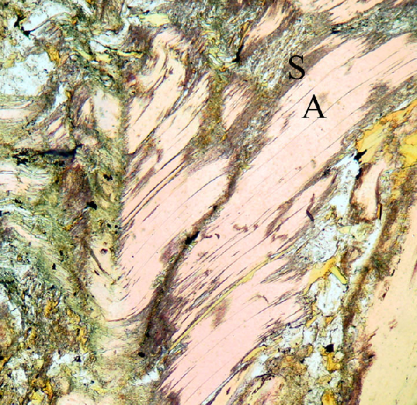
Praborna: retrogression of alurgite.
Alurgite (A, i.e., Mn-rich phengite) was partly transformed to a symplectite (S) of manganophyllite and hyalophane. Plane-polarised light.
Figure 37. Retrogression of alurgite
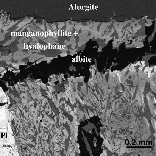
Praborna: retrogression of alurgite.
Alurgite (i.e., Mn-rich phengite) was partly transformed to a symplectite of manganophyllite and hyalophane. Albite occurs in a late small vein. Pi = Piemontite. Back-scattered electron image.
Figure 38. Retrogression of violan
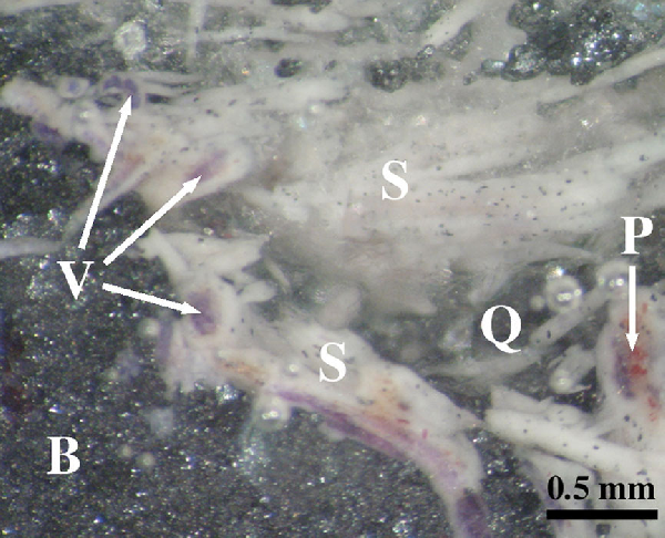
Praborna: retrogression of violan.
Violan (V) corroded by a Cpx+albite symplectite (S), in a matrix of braunite (B) and quartz (Q), with minor reddish piemontite (P).
Figure 39. Retrogression of violan
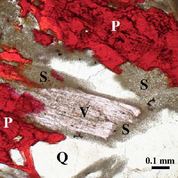
Praborna: retrogression of violan.
Rock with piemontite (P), quartz (Q) and violan (V) partly transformed into a Cpx+albite symplectite (S) during retrogression. Plane-polarised light.
Figure 40. Retrogression of violan
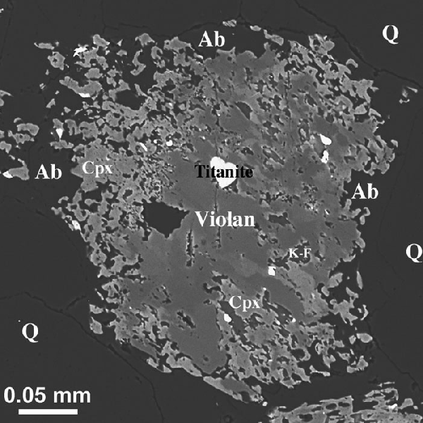
Praborna: retrogression of violan.
Violan (i.e., Mn-rich omphacite) was transformed at contacts with quartz (Q) to a symplectite of albite (Ab) and jadeite-free Cpx, with minor K-feldspar (K-F) [i.e., Jd s.s. in violan + Q = Ab]. Back-scattered electron image.
On the way back from Praborna, after a 30-mn walk, turn to the left in the old “Strada Cavour” that leads to Plout (fork at N 45° 41.811’, E 7° 27.252’, alt. 1738 m). The pathway zigzags down to the valley. In a few points, slags similar to those of Stop 2.5.4 are visible.
The abandoned village of Chuc (Fig. 41) has been in activity from 1854 to 1950 (Cesti, 1978; Lorenzini, 1998). It consists mainly of 3 ruined houses (office and guardian house; workers’ dormitory). The site was linked to the Servette and Chuc mines through cableways, whose terminal is still visible.
The copper mine of Chuc, whose geological setting is quite similar to that of Servette, was located on the other side of the river at altitudes between 1283 and 1443 m (very difficult access). It comprises five major mineralised levels, WNW-trending and SSW-dipping, that are located at the glaucophanite - chloriteschists boundary, as observed in the galleries of the mine.
The ore was sent by another cableway to a lavery located at an altitude of 1211 m, on the western bank of the river, but visible from “Strada Cavour”. There, the ore was crushed and enriched in sulphide, and then transported to Saint-Marcel by a 4-km-long pipe or, in the last years, by a cableway.
A few hundreds of metres below Chuc, the pathway crosses a small river that descends from Servette. The water, being saturated in Cu, has deposed a blue gel that covers the rocks and pebbles of the river bed (Fig. 42). This spectacular “fontaine verte” was described by Saint-Martin de La Motte (1784-85), Horace-Bénedict de Saussure (1796, t. 4, p. 459), Prosio (1903), Noussan (1972) and Zinetti (2002). The gel is made of an almost amorphous Cu hydroxide (Woodwardite), which likely precipitates during a change of pH. A few metres uphill, it can be seen actually that the deposit results from the mixing of two water streams, at the confluence of two small rivers, one coming from the Galleria Ribasso of Servette (1789 m) and the other from the Chuc village (Zinetti, 2002). In the same place, loose blocs of glaucophanite and chloriteschists, with chloritoid up to a few cm in size, can be observed.
Continue the path northwards, along the Saint-Marcel River. In the river bed, one can see, together with the meta-ophiolite of the Zermatt-Saas unit, large blocks of marble, eclogite and eclogite-facies gneiss that comes from the Monte Emilius klippe (intermediate continental unit) that overlies the meta-ophiolite. This highly retrogressed eclogite-facies gneiss (the so-called Gneiss pipernoidi of Amstutz, 1951) is a banded rock with leucocratic bands (quartz + albite + phengite + microcline + epidote) alternating with layers and lenses rich in chlorite and actinolite, with rare omphacite, glaucophane or crossite. Continue down to Plout, where a splendid church of the 17th century can be visited.
Figure 42. Green fountain (Acqua Verde)
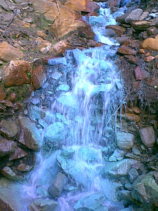
Green fountain (Acqua Verde).
A blue gel covers the stones of the river.
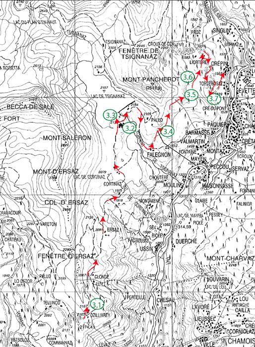
This itinerary (Fig. 43) is mainly devoted to the (ultra-) high-P metamorphism that developed in the Zermatt-Saas ophiolite during the Alpine orogeny. We shall visit the famous coesite-bearing occurrence of Lago di Cignana and the eclogite-facies metagabbro of Crepin, which still preserves its magmatic structure. The excursion also offers the opportunity to observe the tectonic relationships between the Piedmont meta-ophiolite and the overlying Dent Blanche nappe.
In 1792, H.-B. de Saussure visited the Valtournanche valley, and undertook the first trigonometric calculation of the height of the Monte Cervino (Matterhorn), obtaining an estimate of 4505 m (instead of 4478 m). At the end of the 19th century, in 1869, Felice Giordano made the first geological survey and barometric measurements of Cervino (Dal Piaz, 1996). Afterwards, Émile Argand particularly studied the Dent Blanche nappe and interpreted the tectonic structure of the Penninic zone in Western Alps in terms of multiple recumbent folding (see Dal Piaz, 2001b). More recently, Giorgio Vittorio Dal Piaz and Jean-Robert Kienast applied the concepts of subduction metamorphism and plate tectonics to the Valtournanche area and surroundings
We head towards Cignana entering the Valtournanche valley. North of Champlong, we follow the Marmore river that cuts across the meta-ophiolite of the Zermatt-Saas unit (serpentinite, ophicalcite, metagabbro, metabasalt and minor metasediments, locally well preserving eclogite-facies assemblages), whereas the Combin ophiolite takes up the heights, on both sides of the valley.
We head up Torgnon and Mongnod, and, from there, a private road (permission required), along which calcschists of the Combin unit are dominant, leads us to Gillaray. As we climb up, grand views of the Valtournanche valley and Cervino appear to us. Near the Gillaray oratory we climb the small hill to the NW in order to observe a panoramic view.
To the West, we can see the tectonic contact between the Combin meta-ophiolite (Monte Meabè) and the overlying Dent Blanche-Mont Mary system, with the Gneiss Arolla basement unit (Monte Miracolo) and its Mesozoic cover (Cima Bianca).
To the North, the Pancherot hill is made of a huge ophiolitic serpentinite capped by Triassic quartzite and platform carbonates of the Pancherot-Cime Bianche decollement unit. Behind (Fig. 44), we observe the Testa del Leone and Cervino (southern face), made, from top to bottom, of Valpelline kinzigite, Arolla gneissic granitoids and Permian metagabbro (Dent Blanche). The tectonic substratum of Cervino, the ridge from the Cervino to the Theodul Pass and the Plateau Rosa (Testa Grigia) klippe are made of Combin ophiolite, whereas the Breithorn, on the right, already belongs to the Zermatt-Saas unit. The contact between this meta-ophiolite and the underlying Monte Rosa basement occurs further east, between the snowy Polluce and Castore peaks.
East of the Valtournanche valley, the contact between the ophiolitic Zermatt-Saas (Plan Maison) and Combin (Grand Tournalin) units is outlined by a light-coloured horizon of Permian-Mesozoic rocks, mainly Triassic (Pancherot-Cime Bianche decollement unit). Further south, the Combin meta-ophiolite is overthrust by the Pillonet klippe (Dent Blanche s.l.), which is characterized by a blueschist-facies imprint of Late Cretaceous age (Cortiana et al., 1998).
To the south, on the opposite side of the Aosta valley, one can see the Monte Avic (Zermatt-Saas) ultramafic massif, the Austroalpine Monte Emilius continental slice and the Penninic Gran Paradiso unit.
Figure 44. View northwards from Gillaray
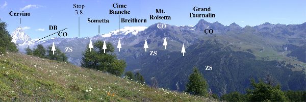
View northwards from Gillaray.
DB = Dent Blanche nappe, CO = Combin meta-ophiolite, ZS = Zermatt-Saas meta-ophiolite. The white arrows point to the thin slice of Permo-Mesozoic sediments (Pancherot-Cime Bianche unit) that separates the Combin and Zermatt-Saas units, and which generally appears as white cliffs.
We continue until we reach the parking of Rifugio Barmasse (2169 m), near the Lago di Cignana (2162 m), which is a famous coesite occurrence. Before looking at the rocks in detail, give a look at the panorama to the north-west, in front of you (Fig. 45).
Your feet are resting on the high-P metabasites and metasediments of the Zermatt-Saas unit (micaschists and quartzite with large garnet crystals). To the north-east (i.e., on your right looking at the lake), the Monte Pancherot (2614 m) is composed of a slice of folded serpentinite (Zermatt-Saas or lower Combin unit). It is overlain, to the north, by a slice of Permian-Mesozoic continental metasediments (mainly Triassic quartzite, marble and dolomite), which crop out along the lake shore near a small church (2178 m). Behind the lake, the Combin unit, here mainly consisting of calcschists with minor prasinite, metagabbro and serpentinite bands, is tectonically flattened and poorly exposed. Above the Combin unit, the Austroalpine Dent Blanche-Mont Mary composite system occurs from the waterfall to the horizon line, with basement rocks (mainly Gneiss Arolla) and Mesozoic cover (Roisan zone: Château des Dames and Becca di Salè). Further south-west, the two contacts Zermatt-Saas – Combin and Combin – Dent Blanche can be seen again on the slopes of the Becca di Salè and Cortina area (i.e., on the left side of the lake), where they dip to the north-west.
The Cignana Mesozoic metasediments crop out as a thin level that extends on the south-west and south-east shores of Lago di Cignana. They belong to the upper part of the ophiolitic Zermatt-Saas unit, immediately below the contact with the overlying Combin unit. South of the dam, metabasic rocks prevail over metasediments, which gradually predominate to the west and north-west of the lake. The lake shore offers a continuous outcrop that allows observing the superposition of different fabrics and the relationships among various lithologies (Fig. 46). Most of the following description is summarised from the detailed studies of Reinecke and co-workers (Reinecke, 1991; Reinecke et al., 1994; Van der Klauw et al., 1997; Reinecke, 1998; Reinecke et al., 2000). The various rocks, which are believed to represent a former section of oceanic crust, seem to have undergone a similar metamorphic ultrahigh-P evolution.
Figure 46. Simplified geologic map
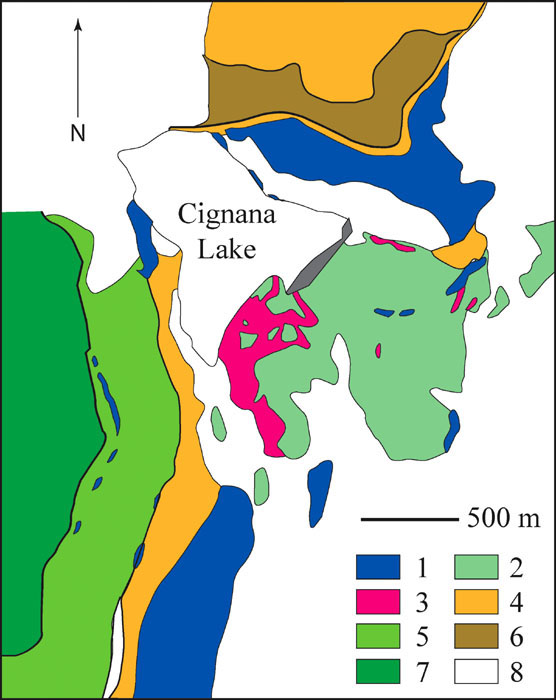
Simplified geologic map of Cignana Lake surroundings, redrawn from Reinecke (1998).
1 = serpentinized ultramafics; 2 = coesite-eclogite and derived greenschists; 3 = UHPM metasediments; 4 = greenschists interlayered with minor calcschists (Combin Zone); 5 = calcschists with minor greenschists and marble (Combin Zone); 6 = dolomite – calcite marble; 7 = Austroalpine undifferentiated; 8 = scree and moraine deposits. Solid thick lines = tectonic contacts.
Metabasites are represented by variously deformed and retrogressed eclogite, glaucophanite and eclogite-facies metagabbro. Pillow structures have been recognised, and the geochemical signature is similar to that of modern oceanic rocks (N-MORB). Samples that are devoid of retrogression and post-eclogite deformation have preserved an ultrahigh-P assemblage consisting of garnet, clinopyroxene, glaucophane, clinozoisite, zoisite, rutile, apatite and paragonite. Occasionally, phengite and dolomite are found. However, the presence of paragonite texturally in equilibrium with the high-P assemblage is not clearly understandable, as it should not be stable at the P-T conditions determined for these rocks (2.6-3.0 GPa, 600°C). Various degrees of retrogression affect these rocks, from greenschist-facies assemblages rimming high-P minerals to completely retrogressed rocks, especially at the high-strain rims of boudins, consisting of actinolite, albite, chlorite and epidote. Numerous shear bands, variously oriented veins and folds help to constrain the exhumation path (see Van der Klauw et al., 1997, for details).
Metasediments are described in detail by Reinecke (1998). The ultrahigh-P assemblage consists of garnet (Fig. 47), dolomite, aragonite, lawsonite, coesite, phengite in calcschists and of garnet, phengite, coesite ± epidote, talc, dolomite, Na-pyroxene and Na-amphibole in micaschists. Boudinaged levels of Mn-rich quartzite are also observed.
Ages of the high-P metamorphism have been recently obtained by two works (Rubatto et al., 1998, U-Pb=44.5±2.3 Ma and 43.9±0.9 Ma; Amato et al., 1999, Sm-Nd=40.6±2.6 Ma). Moreover, Amato et al. (1999) infer a rapid exhumation, from the Rb-Sr cooling ages. Note that coesite-free eclogites from the same unit in the nearby upper Ayas valley display Sm-Nd (garnet-pyroxene) and Rb-Sr (phengite) ages of 49 and 46 Ma, respectively (Mayer et al., 1999).
Figure 47. Garnet in quartz-rich metasediments
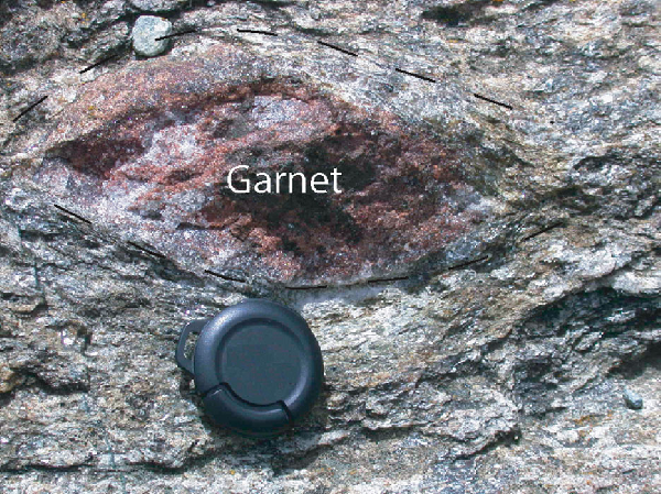
Decimetric garnet in quartz-rich metasediments at Lago di Cignana.
Lens cap diameter 3 cm.
Go to the small mound situated in the parking area towards the south-western extremity of the dam. There, you can see a 2-m-high outcrop consisting of banded garnet quartzite, with late quartz veins. We can recognise two 2-cm-thick pink layers containing alurgite (Mn-mica), spessartine, piemontite and rare, cm-sized lenses of braunite (Dal Piaz et al., 1979a). A green level consists of phengite, epidote, hematite ± garnet.
Descend to the lake shore, near the southern extremity of the dam.
Eclogite bands and lenses (Fig.48), deformed together with metasediments, occur on the shore. They are often layered, with bands rich in garnet+omphacite and others rich in glaucophane. Phengite and epidote are also visible. The foliation and lineation are outlined by prismatic minerals of the high-P assemblage, especially glaucophane. The foliation wraps garnet crystals, and pressure shadows consist of coarse-grained omphacite. The eclogites are variously retrogressed to greenschist facies, and retrogression is complete towards the rims.
Progress towards the south-west, along the lake shore, where a few dm-to-m-sized lenses of coarse-grained metagabbro occur in the metasediments (micaschists; quartzite containing garnet crystals up to 5 cm in diameter). The undeformed metagabbro, wrapped by mylonitic metagabbro, has preserved igneous texture defined by up to 5 cm emerald-green clinopyroxene crystals, now mainly omphacite, often retrogressed to green amphibole at margins and along cracks. A few metres above, a polished surface allows to see the relationships of less deformed lenses with mylonites (interference figures) and the folded contact with metasediments.
Going further south along the lake, we can observe metabasite boudinaged within metasediments. Between metabasites and quartz- or carbonate-rich metasediments, reaction rims (Fig. 49) consist of a cm-thick discontinuous band of chlorite (close to the metabasite) and a dm-thick band of rich in epidote (close to the metasediment). Note also the superposition of different deformation phases (interference figures). Further south, metasediments prevail, with marble levels.
Figure 49. Deformed reaction rim
Lago di Cignana: deformed reaction rim between a basic boudin (to the top) and metasediments (to the bottom).
Note dark chlorite layers and light epidote layer towards the metasediment. Lens cap is 3 cm.
We leave Cignana following pathway N1 (yellow triangle), descending south of the dam. Below the dam, we cross prevalent metasediments (quartzite, micaschists, calcschists with lawsonite pseudomorphs) and metabasites (banded eclogite and glaucophanite). On the way down, various metabasites (eclogite, metagabbro, and serpentinite) are found in debris along the path (give a look at the stair steps).
After the ruined village of Falegnon, turn to the left (fork at N 45° 52.302’, E 7° 36.218’, 1908 m). The path passes under the pipe of the hydroelectric power station (small tunnel at N 45° 52.402’, E 7° 36.295’, 1923 m).
At about 350 m after the pipe, large outcrops are visible on the left side of the pathway (N 45° 52.509’; 7° 36.530’; alt. 1891 m.). Banded eclogite, glaucophanite, serpentinite, calcschists and layered marble alternate and are folded together. The foliation and transposed layering dip of about 45-50° towards the north-west.
Carbonate-rich rocks contain calcite, white mica, epidote and rare tourmaline, all aligned along the main foliation. Elongated aggregates consist of plagioclase, epidote and white mica (plus minor opaques), and could represent former lawsonite.
Eclogites are fined grained. They consist of garnet, omphacite, rutile and glaucophane. Rims of green barroisitic amphibole are present.
From the pathway, we can see the Breithorn and Gobba di Rollin (Zermatt-Saas serpentinite) and the Grand Tournalin, on the other side of the Valtournanche valley. Note the contact between the Zermatt-Saas and Combin units outlined by a light-coloured horizon of Triassic rocks (Grand Tournalin; see Stop 3.1).
At N 45° 52.687’, E 7° 36,903’ (alt. 1892 m.), the path divides into two branches, which, actually, lead to the same major path that must be followed northwards.
Along the main way, 20 m south of the junction with the upper branch of the pathway, near the sign “17”, 2 boudinaged dm-thick dykes of rodingitized metagabbro are visible in the serpentinite. They are mainly made of Ca-Fe garnet and epidote, with minor diopside and chlorite.
Continue the way towards north. We first observe dominant strongly-foliated serpentinite, with a few transposed and boudinaged dykes of metagabbro. Further north, the metagabbro (with a flaser structure, by places) becomes prevalent over the serpentinite, which occurs as lenses of a few metres in size.
One of these serpentinite lenses shows a 30-cm-thick reaction rim (Fig. 50), with concentric bands:
serpentinite | tremolitite | tremolite + talc | chlorite + tremolite | transformed gabbro, with epidote + chlorite | metagabbro.
Figure 50. Reaction rim
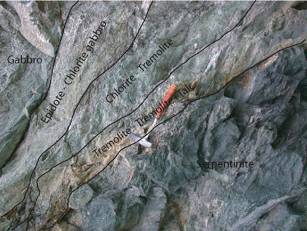
Macroscopic reaction rim between gabbro (on the left) and serpentinite (on the right).
See text for details.
From Liortere, the pathway zigzags downhill towards Crepin. A huge mass of blocks, which resulted from an ancient rock fall, occurs at a few tens of metres southwards of the pathway. It is easily accessible from the last bent of the pathway before Crepin village (N 45° 52.619’; E 7° 37.095’; alt. 1630 m). The blocks are mainly made of metamorphic troctolite and gabbro, with a prevalent eclogite-facies imprint. They come from an inaccessible ridge below Monte Pancherot.
These rocks show peculiar textures and metamorphic transformations. Troctolite (Fig. 51) and gabbro (Fig. 52), originally composed of olivine, plagioclase and clinopyroxene, have undergone static metamorphic reactions. Rocks display a whole range of transformations, from very thin coronitic reactions (Fig. 53) giving rise to eclogite-facies minerals to complete replacement of igneous minerals by new high-P assemblages.
Figure 51. Fine-grained metatroctolite
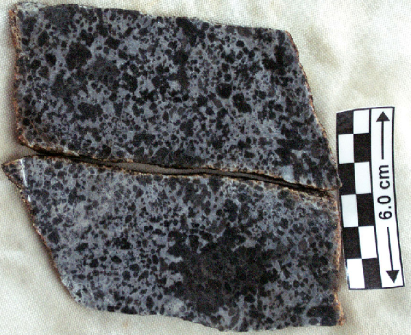
Crepin: fine-grained metatroctolite with poikilitic clinopyroxene.
Olivine: dark and rounded, plagioclase: white, pyroxene: grey.
Figure 52. Coronitic troctolite
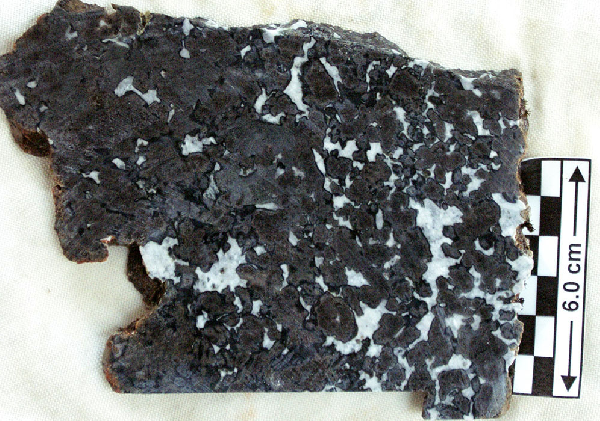
Crepin: coronitic troctolite.
Plagioclase is white, olivine dark grey and rounded, with lighter talc and darker garnet concentric coronas.
Figure 53. Partially eclogitized troctolite
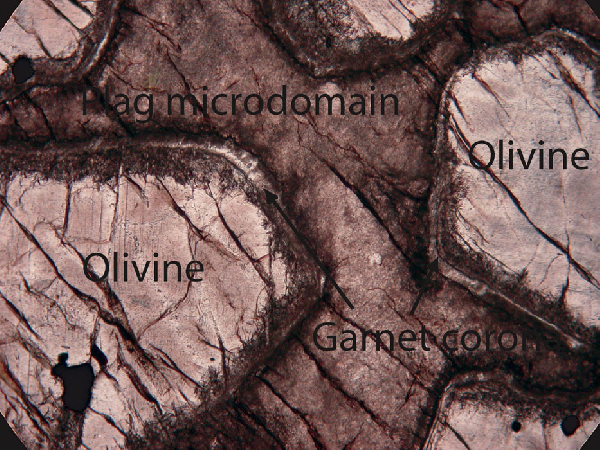
Crepin: partially eclogitized troctolite.
Plagioclase is completely transformed to a fine-grained aggregate. Olivine is preserved. A thin, complex corona develops between the two. Olivine grains are 3-5mm, plane-polarised light.
In completely transformed troctolite (Fig. 54, Animation 54), fine-grained jadeitic clinopyroxene and clinozoisite replaced igneous plagioclase. Towards olivine microdomain, small kyanite crystals are found around large clinozoisite, together with micas (phengite and paragonite), chloritoid and garnet that forms irregular coronas at the former plagioclase-olivine interface. Olivine is mainly transformed to talc. Nonetheless, large tremolite crystals are common, together with very fine-grained omphacite, phengite, chloritoid, chlorite, kyanite and even rare quartz. Cr-rich clinopyroxene is partially to completely overgrown by omphacite. This latter may be overgrown by Cr-rich chloritoid and talc.
Figure 54. Eclogitized troctolite
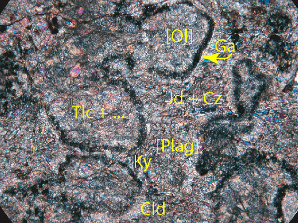
Crepin: completely eclogitized troctolite.
Former rounded olivine [Ol] and anhedral plagioclase [Plag] are replaced by aggregates of talc (Tlc) and of Clinozoisite (Cz) + Kyanite (Ky) + Chloritoid (Cld) ± Jadeite (Jd), respectively, separated by a garnet (Ga) corona. Former olivine grains are 2-4 mm.
In incompletely eclogitized rocks (Fig. 55), igneous minerals (olivine and clinopyroxene) are rimmed by eclogite-facies complex coronas:
Olivine | talc | clinopyroxene | chlorite | garnet | plagioclase pseudomorph (Fig. 56);
Augitic clinopyroxene | omphacite | plagioclase pseudomorph (Fig. 57).
Plagioclase pseudomorph is made of clinozoisite + albitic plagioclase + garnet ± jadeite ± kyanite.
The various degrees of development of eclogite-facies reactions are related to the intensity of the oceanic hydrous alteration that took place before eclogitization (Ayas-Valtournanche area: Ernst and Dal Piaz, 1978; M. Viso: Messiga et al., 1999). The effect of the oceanic metamorphism in the Zermatt-Saas ophiolite was also evidenced through isotope studies (Cartwright and Barnicoat, 1999). The main effect due to oceanic metamorphism was the development of low-grade hydrous assemblages, which favoured the chemical homogenisation of the igneous microdomains and the kinetics of subsequent eclogite-facies metamorphic reactions (Messiga and Tribuzio, 1991). It is thus possible to find side by side classic and hydrous eclogite-facies metagabbros.
Geothermobarometric computations and calculation of P-T pseudosections for the various microdomains of these rocks (Rebay and Powell, 2002) have provided P-T estimates of P ≥ 2 GPa and T˜600°C for the eclogite-facies reequilibration.
Among the blocks, there are also several examples of metatroctolite and metagabbro that underwent greenschist-facies retrogression following the high-pressure metamorphism, with the development of green amphibole, chlorite and albite.
We return to the way, which we follow down to the Crepin village.
Figure 55. Partially eclogitized gabbro
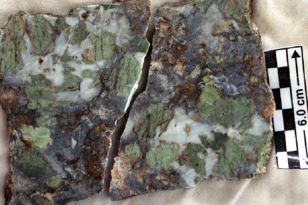
Crepin: partially eclogitized gabbro.
Clinopyroxene is green, former plagioclase white and former olivine (transformed to talc) is rounded brownish. Garnet-bearing corona developed among the different microdomains.
Figure 56. Multilayered corona developing between olivine and plagioclase
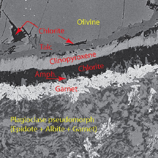
Multilayered corona developing between olivine and plagioclase in incompletely eclogitized metatroctolite.
Back-scattered electron image.
Figure 57. Corona between augitic clinopyroxene and plagioclase
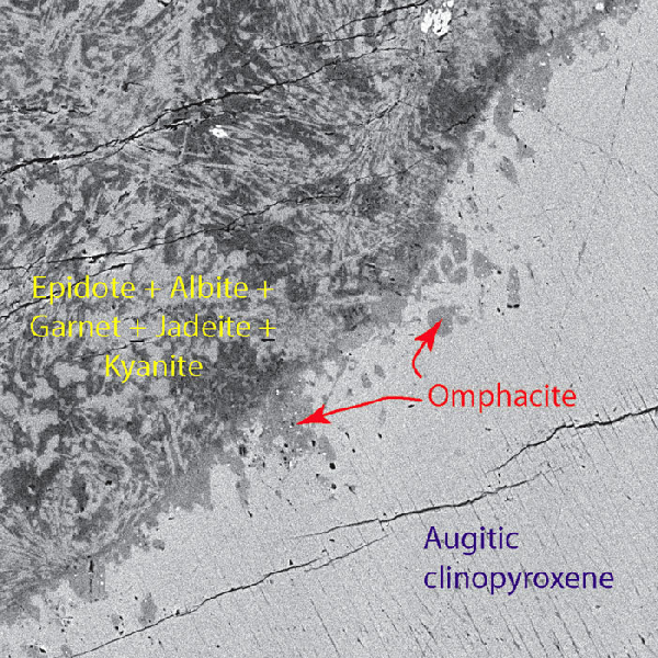
Crepin: corona between augitic clinopyroxene and plagioclase in partially transformed eclogite-facies gabbro.
Back-scattered electron image.
We drive to Breuil (Cervinia) and take cableways, first to Plan Maison and Plan Tendre lake and then to Testa Grigia, from where we have a spectacular view of the collisional zone of the Western Alps, particularly on the tectonic units we have crossed in the previous days.
The Testa Grigia summit is made of a small klippe of the Pancherot-Cime Bianche unit, which separates the Zermatt-Saas meta-ophiolite (below Testa Grigia) from the Combin unit (above, present to the NW). It is a decollement cover sheet of continental affinity, made of tabular white quartzite, marble, sedimentary breccia and calcschists, of Eo-Trias to Jurassic age (Dal Piaz, 1992).
From the top to the base of the Cervino (Fig. 58), we observe the Dent Blanche (i) kinzigitic gneiss, (ii) the gneissic metagranitoids of the Arolla series, (iii) a thick mylonitic horizon of metagranitoids and metagabbros, (iv) the huge Early Permian metagabbro body, underlain by (v) thin basement mylonites, and (vi) the underlying ophiolitic Combin unit. The Dent Blanche – Combin (i.e., Adria microplate – Tethys ocean) tectonic contact is visible along the whole ridge, between Cervino and Monte Rous, through the Grandes et Petites Murailles. The whole nappe stack, from the Zermatt-Saas ophiolite to Dent Blanche-Mont Mary system through the Combin unit and the Etirol-Levaz slice, can be seen along the western flank of the upper and middle Valtournanche.
Figure 58. Panoramic view from Testa Grigia towards the SW

Panoramic view from Testa Grigia towards the SW.
VP – Valpelline kinzigitic units, AR – Gneiss Minuti and metagranitoids of Gneiss Arolla; Gb – Permian gabbros; m – mylonites around gabbros; CO – Combin ophiolite; PCB – Pancherot-Cime Bianche-Bettaforca Unit. (after Dal Piaz, 1992, vol. 1, Fig. 7.14).
At our feet, we have the Plan Tendre-Plain Maison area, with the eclogite-facies ophiolitic rocks of the Zermatt-Saas unit, all around the Goillet Lake. To the left of the lake, from Sommetta to Roisetta, a NNW-SSE-oriented light-coloured ridge is again made of the Pancherot-Cime Bianche exotic metasediments, presently trapped between the Zermatt-Saas and Combin ophiolitic units.
The Breithorn serpentinitic massif (Zermatt-Saas unit; 4139 m) is visible to the east. The two following peaks, Polluce (Zermatt-Saas; 4090 m) and Castore (Monte Rosa unit; 4225 m) point out the limit between the ophiolite (i.e., Tethys ocean) and the Penninic (i.e., European) domains.
From the Chalet (Fig. 59), we can have a view towards Switzerland, on the Adria (Austroalpine) continental fragment of the Cervino-Weisshorn ridge, the underlying Combin and Zermatt-Saas units, which are thrust over the Upper/Inner Penninic Monte Rosa unit (European margin) and capped in turn by the Mid Penninic Gran St. Bernard nappe (Briançonnais) along the Mischabel backfold. The Helvetic basement in the Bern Oberland is visible far to the north.
Figure 59. Panoramic view from Testa Grigia towards Switzerland

Panoramic view from Testa Grigia towards Switzerland from the Chalet (looking towards N).
AR – Gneiss minuti and metagranitoids of the Gneiss Arolla Unit; CO – Combin greenschist-facies ophiolite; ZS – Zermatt-Saas eclogite-facies ophiolite; MR – Monte Rosa; SB, C, BR and R – Gran San Bernardo Units; s – serpentinite; r – rodingite; gs – gabbro and serpentinite; mc – garnet-chloritoid micaschists with basic inclusions; cp – calcschists and prasinites; mo – moraines. After Dal Piaz, 1992, vol. 1, Fig. 7.16.
