Field excursion
Reaching Joshimath
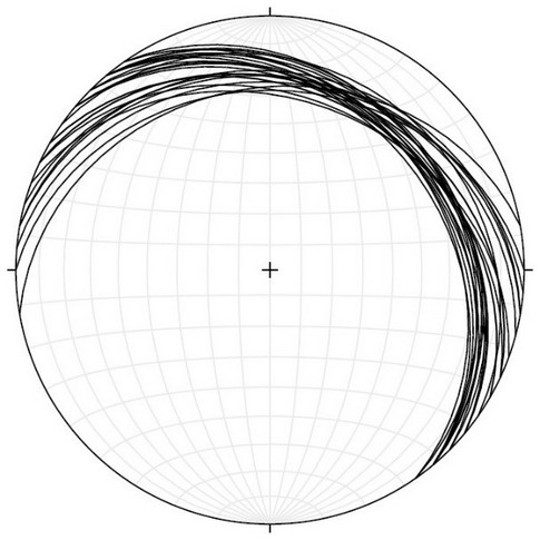
All the foreign nationals may travel by air to Delhi/Dehra Dun and then to Haridwar either by train/road. This picturesque religious place, on the right bank of River Ganga, provides a glimpse of the Cenozoic foreland Middle Siwalik Group rocks. Next day involves a long road journey northeastwards for about 300 km upstream along the mighty Alaknanda River from Haridwar to Joshimath. Most of the Journey is through the wide, meandering and picturesque Alaknanda River as one mostly travels through the Lesser Himalayan sedimentary sequence. Stay is at Joshimath, and since it is a long journey, it is suggested that the team takes rest on the first day when it reaches Joshimath and completes the formalties regarding permission etc. Since it is a restricted area near the border with Tibet, satellite phones and GPS are not permitted and under very strict servelliance by the Government of India for security reasons, hence you are advised not to use them at all and carry them beyond Joshimath. Field stops are numbered as Stops 1, 2 etc., while the original locations in our field research work are numbered as RM-, H- and T- series for co-ordination.
Starting the actual field excursion from the Joshimath camp, following are the day-wise detailed field visits and movement programme.
Day 1: Patalganga-Helang
The first day is devoted to critical observations along the Alaknanda River from the village Patalganga to Helang involving Proterozoic Lesser Himalayan Sedimentary Sequence (LH), its deformation and the MCT zone. One starts travelling across dominant lithology of the Lesser Himalayan quartzite belonging to the Garhwal Group/Berinag Group from the Patalganga village upstream along the Highway NH-58 northwards towards Helang through the villages of Langsi and Gulabkoti..
Stop. 1.
Locality: About 30 m south of Langsi. H-42 (N30°29’33”:E79°29’1”)
Theme: Lesser Himalayan Sedimentary Sequence (LH) and its deformation.
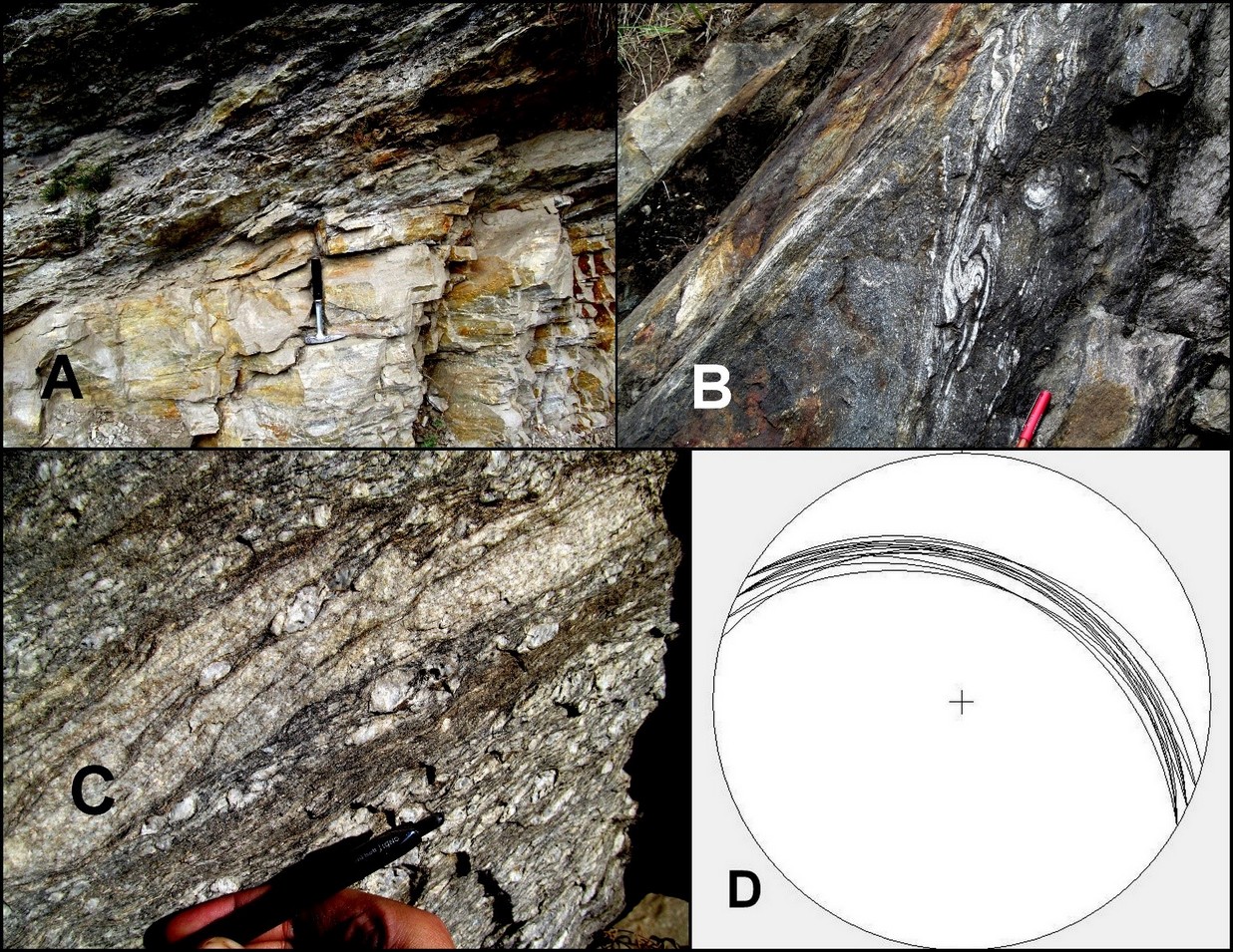
As one moves northwards from the Patalganga village towards Helang, typical slate of the Lesser Himalayan Sequence can be observed (Fig. 2A), which are intercalated with light-colored foliated as well as massive quartzite throughout from Langsi to Helang (Fig. 2B). The LH sequence strikes almost NW-SE and dip about 33° NE (Fig. 2D). Sigmoidal σ-shaped veins, S-C shear fabric and rootless folds reveal a consistent top-to-the-SW upwards shear sense in the Lesser Himalayan Sequene much farther south from the MCT (Fig. 2.1C).
Stop. 2.
Locality: About 500 m north of Langsi. H-40 (N30°29’51”:E79°29’5”)
Theme: Lithology of the Lesser Himalayan quartzite.
A huge exposure of typical cliff-forming light-colored Lesser Himalayan Garhwal Group quartzite can be observed at this stop (Fig. 3A). The rocks show a shear sense of top-to-the SW and are highly foliated. The quartzites strike about NW-SE and dip 30° due N to NE (Fig. 3B). The strong sericite and quartz mineral lineation in the quartzite plunges N15° at about 25° (Fig. 3C).
It is worthwhile mentioning that dominant lithology in this part of the Lesser Himalayan Sequence is still quartzite, though there are intercalations of highly deformed and foliated schist within the quartzite.
Figure 2. Rocks of the Lesser Himalayan Sequence
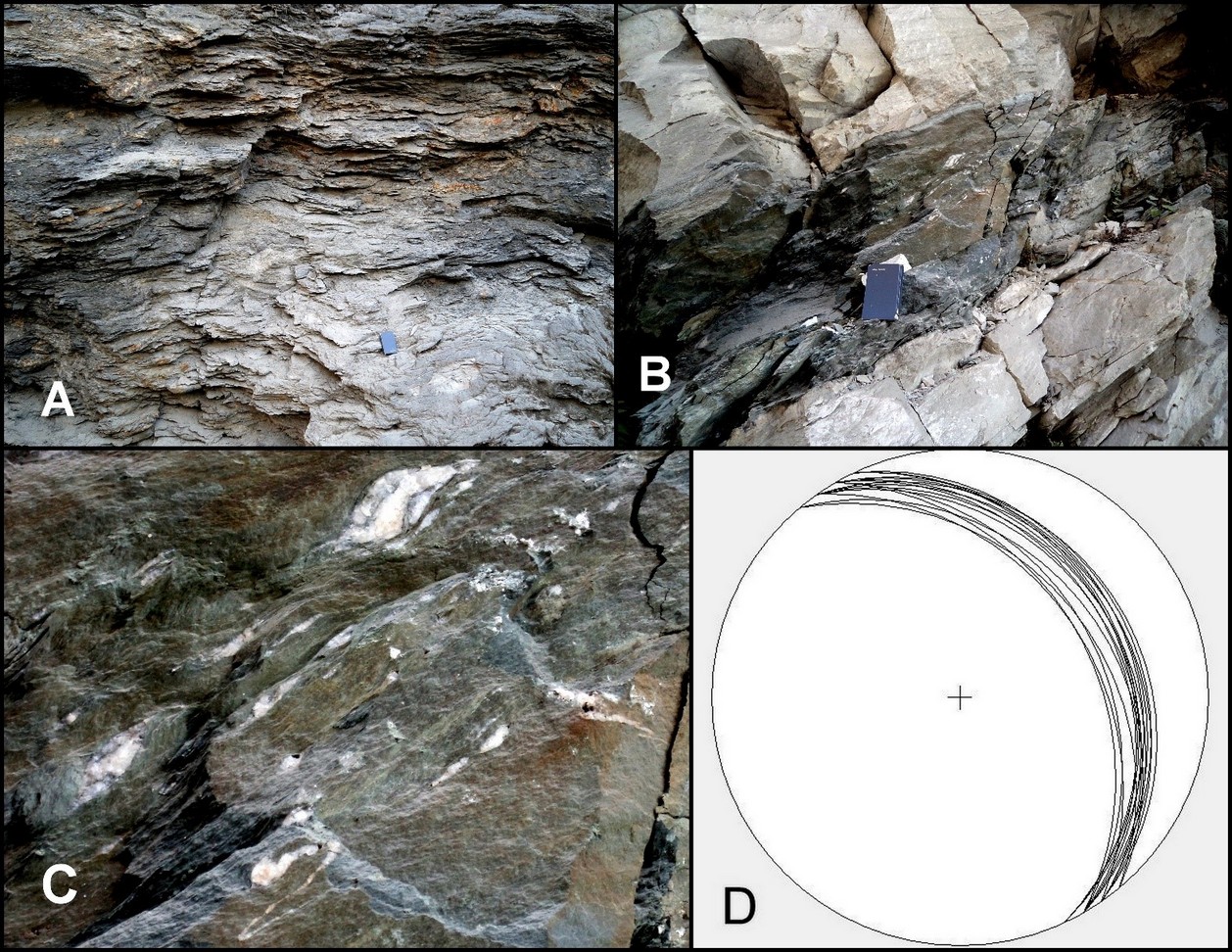
(A) Typical slate of the Lesser Himalayan Series sequence at Langsi. (B) Intercalated schist and quartzite. (C) Sigmoidal structure, S-C fabric and asymmetrical fold indicating sense of shear and (D) Stereo plot of main foliation Sm at the Stop 1
Stop. 3.
Locality: About 350 m north of Gulabkoti. H-32 (N30°30’48”:E79°29’33”)
Theme: Rootless folds in the Lesser Himalayan quartzite.
Another excellent exposure of the Lesser Himalayan quartzites is observed at this stop. The quartzite strikes nearly WNW-ESE and dips 35° NE (Fig. 3D), while the lineation is oriented N20°/30° (Fig. 3E). Asymmetrical folds having sheared and appressed limlbs with a top-to-the-SW shear sense are also observed in the highly deformed schist (Fig. 3F).
Helang-Joshimath
In the afternoon of Day 1 field work is focused on the Munsiari Group rocks of the MCT zone. This is critical for understanding the relationship between Munsiari and Vaikrita Thrusts in this region. For this purpose, detailed observations are made along the main Highway NH-58 between Helang and Joshimath and along a side road that bifurcates to Shelang village.
Figure 3. Rocks and deformation within the Lesser Himalayan quartzite
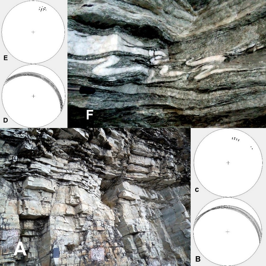
(A) Bedded and gently-dipping Lesser Himalayan quartzites. (B), (C), (D), (E) – Foliation and lineation data plotted on stereonet for Stops 2 and 3, respectively. (F) Asymmetrical folds in a narrow zone showing to top-to-the-SW sense shear
Stop. 4.
Locality: About 250 m south of Helang Bridge. RM-35/H-26 (N30°31’32”:E79°30’30”)
Theme: Deformation within the MCT zone.
After observing the Lesser Himalayan quartzites south of the village Helang, one moves further northwards, where psammite are interbanded with schist; both are more strained. Magnificent S-C-C’ fabric in the form of asymmetrically sheared boudin (Fig. 4A) is observed at this exposure indicating a top-to-the-SW shear sense. Near this stop, one can observe typical S-C shear fabric affecting the intercalated psammite/qtz-bio schist (Fig. 4B). The schist, in general, strikes about W-E to NW-SE and dips 43° N to NE, and a strong mineral lineation plunging down-the-dip. The grade of metamorphism in this region is distinctly higher as compared to the southern parts of the Alaknanda Valley.
Stop. 5.
Locality: About 2 km NE from Helang village. RM-37/H-22 (N30°31’50”:E79°30’53”)
Theme: Mylonite of the Munsiari Group.
The first exposure of mylonitized gneiss along the Munsiari Thrust, and hence the beginning of the Munsiari Group is observed at this stop. The mylonite is coarse-grained megacrystic gneiss. High strain deformation, as typical of a mylonite, is observed and S-C fabric is well-developed indicating a top-to-SW shear sense. The intensely sheared mylonite strikes nearly W-E to NW-SE and dips 45° N to NE (Fig. 4C). A prominent stretching lineation is observed with a plunge of N20°/45° (Fig. 4D). This sudden increase in deformation in the rocks and presence of a granite mylonite suggests a major break in the litho-sequence indicating a major thrust - the Munsiari Thrust.
It is important to point out that, as we move north for about 2 km, a thick quartzite band is observed which has a strike continuity up to Tapovan.
Stop. 6.
Locality: About 3 km ESE on the side road. RM-45/RM-119 (N30°31’42”:E79°32’18”)
Theme: Quartzite of the Lesser Himalayan within an imbricate zone.
A sharp contact with the dark augen mylonite gneiss overriding the LH quartzite (Fig. 5A) is observed at this stop. This contact is possibly an out-of-sequence thrust which has caused a repetition in the quartzite-mylonite sequence. The gneiss above the contact strikes almost E-W and dips 30° to the N, whereas the quartzite below the sharp contact strikes WNW-ESE to NW-SE and dips 20° N to NE. An angular discordance is distinct between the two sequences.
Figure 4. S-C shear fabric within the MCT zone
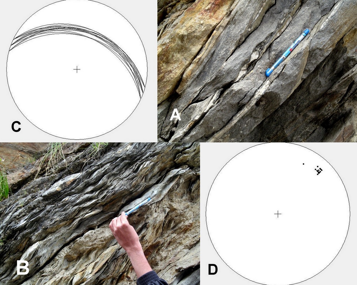
(A) Asymmetrically sheared boudin showing top-to-SW shear sense. (B) Iintercalated psammite/pelite schist with prominent S-C shear fabric. (C), (D) Foliation and lineation data of Location 4 plotted on stereonet, respectively
A variety of magnificent structural features like Type-II superposed mushroom folds (Fig. 5B) and S-C-C’ fabric are observed at this outcrop. The shear sense, as indicated by the S-C fabric and the folds, is top-to-SW. There is intense localization of deformation and shearing at the rocks contact.
At the microscale, the foliation in the gneiss is associated with the dynamic recrystallization of muscovite, biotite and quartz and it is a spaced anastomosing foliation (Passchier and Trouw, 2005). Kinematic indicators are represented by S-C-C’ fabric (Fig. 6A), mica and biotite fishes referable to type 1 and 3 of Passchier and Trouw (2005) and asymmetric pressure shadows around porphyroclasts (Figs. 6A, B). Within the phyllitic layers an older foliation is still recognizable (Fig 6C). In the quarzites layers a continous foliation is defined by the preferred orientation of platy minerals such as chlorite and white mica. The granoblastic quartz matrix, shows evidence of dynamic recrystallization (GBM I of Stipp et al., 2002a, b). Gypsum plate observations also suggest a strong LPO (lattice preferred orientation) in such quartzite.
Figure 5. Out-of-sequence thrusting and deformation of mylonite
(A) Sharp contact between gneiss and quartzite at Stop 6. (B) Type-II superposed mushroom fold. (C) Megacrystic granite gneiss with grain size variation in the ductile shear zone. (D) Foliation data of garnetiferous mica schist of the Joshimath Formation at Stop 9, plotted on stereonet
Stop. 7.
Locality: On the side upper road from Jharkhola towards SE. RM-39/H-11 (N30°31’52”:E79°31’47”)
Theme: Mapping of the Lesser Himalayan quartzite band.
After the observation of the sharp contact between the light-colored quartzite and the dark-colored gneiss, one may move further north along the road, where a repetition of the light-colored quartzite similar to the Lesser Himalayan quartzite is observed. These quartzites are highly foliated and continue along the strike up to Tapovan village. The quartzites strike E-W to NW-SE and dip about 35-40° N to NE. Rootless folds indicating a top-to-SW shear sense and transposed foliation can also be observed at this outcrop. The lineation plunges around N25°/30°.
Figure 6. Microscopic deformation characters
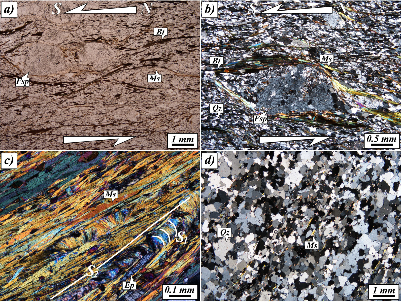
(A) S-C-C’ fabric and feldspar prophyroclasts pointing a top-to-the-south sense of shear (mineral abreviations after Withney and Evans, 2010). (B) Details of feldspar porphyroclast with asymmentric strain shadows in mylonite. (C) S1-S2 relationships within phyllite. (D) Continous foliation developed in quartzite
Stop-8.
Locality: Near Jharkhola. RM-120 (N30°32’3”:E79°32’)
Theme: Mylonite of the Munsiari Group rocks.
After moving further north of the quartzite band, fine-grained as well as coarse-grained megacrystic mylonite is observed at this stop. The mylonitized rocks strike about E-W and dip 30-35° to the N, and a strong lineation develops plunging N15°/40°.
At this stop one can clearly observe a ductile shear zone, evidenced by grain-size variation due to development of alternating ultramylonite bands (Fig. 5C). The mylonitic rocks observed at this stop have the typical lithology of the Munsiari Formation. Wiedenbeck et al. (2014) performed a Cameca ims 4f ion probe 207Pb/206Pb analysis on extracted zircon crystals from this mylonite and obtained a weighted mean age of 1848 ± 5 Ma indicating the age of crystallization of this granitoid protolith, though the age of mylonitization/thrusting along the MCT/Munsiari Thrust remained unconstrained.
Stop. 9.
Locality: About 10 km north of Helang. RM-46/RM-124 (N30°33’14”:E79°32’25”)
Theme: Into the Vaikrita Group
As one moves along the main road further north from Stop 8, a drastic change in lithology is observed from intensely sheared mylonite gneiss to garnetiferous mica schist, suggesting that one has entered into the Joshimath Formation of the Vaikrita Group. The first good exposure of garnet-biotite schist/gneiss, typical of the Joshimath Formation, is observed at this stop (Fig. 7A). The garnetiferous mica schist and garnet-biotite gneiss strikes WNW-ESE to NW-SE and dips 35-40° N to NE (Fig. 5D) and the sense of shear in these rocks is top-to-the-SW.
Figure 7. Garnet porphyroblasts in the Vaikrita Group
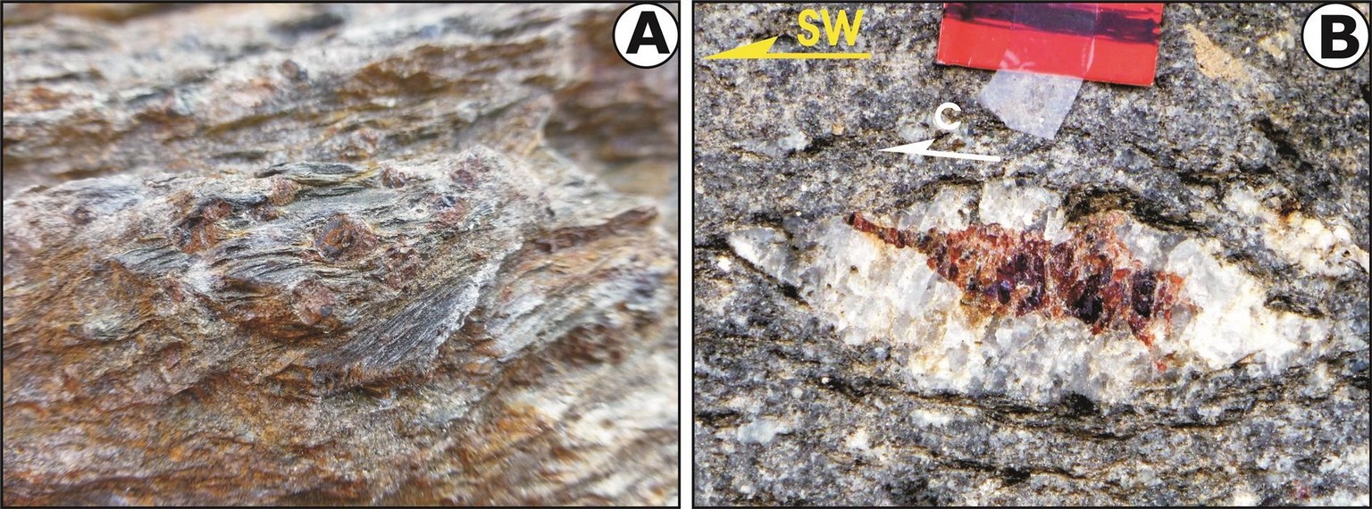
(A) Gently-dipping garnet-biotite schist at Stop 9 of the Joshimath Formation. Note asymmetrical garget augen with tails of the foliated rock, indicating top-to-the-SW shear sense. (B) Tailed garnet asymmetrical porphyroblast in kyanite-garnet gneiss within the Suraithota Formation at Vishnuprayag showing top-to-the SW shear sense. Scale: 2 cm
Day 2: Joshimath to Suraithota
Day 2 involves journey from Joshimath to Suraithota along the Dhauli Ganga River (Fig. 1). Before proceeding to Suraithota, it is better to observe typical Suraithota Formation at Vishnuprayag first by descending to the confluence of the Akalnanda and Dhauli Ganga Rivers. The section first cuts back into the Munsiari Group rocks through the Joshimath Formation rocks, and then back again to the Joshimath Formation. Thus, the Vaikrita Thrust is observed twice along the same road section. The Joshimath Formation finally grades into the psammatic gneiss of the Suraithota Formation. The objective is to (i) locate the Vaikrita Thrust, (ii) carry out detailed analysis of the shear sense indicators, (iii) locate the contact between Joshimath and Suraithota Formations, and (iv) observe the lithology characterizing each formation. The traverse is about 40 km.
Stop. 10.
Locality: Vishnuprayag bridge. RM-48 (N30033’54”:E79034’36”)
Theme: Garnet porphyroblast in the kyanire-bearing Suraithota Formation
This stop is located on the Joshimath-Badrinath sector of the highway at Vishnuprayag - the confluence of the Alaknanda and Dhauli Ganga Rivers, and the place where the former cuts a deep gorge through the Suraithota Formations and becomes almost invisible. As Joshimath and its surroundings habitat are located on a huge paleolandslide zone, exposures are extremely poor till one completes all the loops and approaches the banks of the Alaknanda River. On either side one encounters flaggy psammitic gneiss of the Suraithota Formation, which is best exposed on the right bank of the river. As one approaches the bridge on the Alaknanda River, kyanite-bearing garnetiferous mica schist and gneiss dip into the hill and run almost parallel to the river course. Syntectonically-grown asymmetrical garnet porphyroblast in the porphyroblastic kyanite-bearing garnetiferous mica gneiss/schist of the Suraithota Formation is embedded within quartz (Fig. 7B).
Stop.11.
Location: Barhgaon on the NH 58. RM-129 (N30°31’27”:E79°36’00”)
Theme: Folds in Joshimath Formation.
Typical gneisses of the Joshimath Formation are best exposed along the NH58 road section few kilometres southeast of the Joshimath town after crossing the scree and bad road patch. Quartz veins acquire augen shapes within these gneisses and are discretely sheared (Fig. 8A). Asymmetrical close folds possess steeply-dipping axial surfaces where small amount of movement is recorded indicating top-to-the-SW vergence (Fig. 8B). The rocks of this sequence strike E-W to N325o and dip about 25o-32o towards N (Fig. 9). Lineation trends N50o-65o and plunges down the dip 20o-30o.
Stop. 12.
Locality: About 2.50 Km WNW of Tapovan on the NH 58. RM-71 (N30°30’10”: E79°36’52”.
Theme: Imbricated Lesser Himalayan quartzite
Figure 8. SW-verging asymmetrical folds
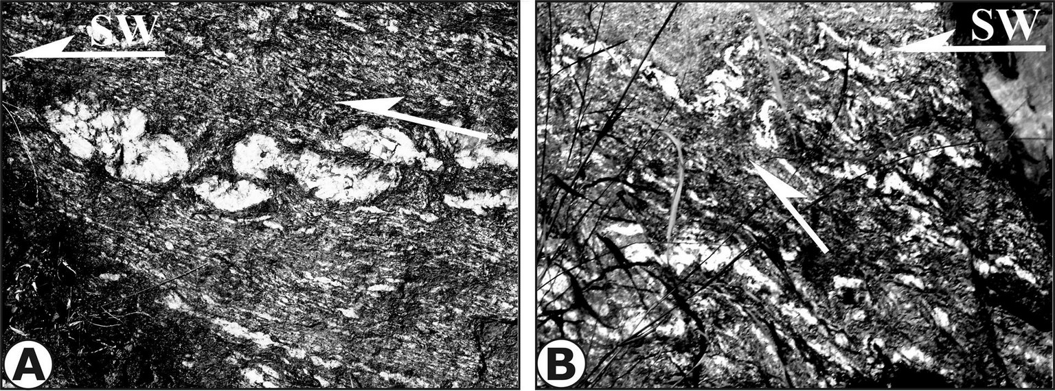
(A) Folded and boudinaged quartz vein in psammatic gneisses of the Joshimath Formation at Stop 11. Shear zone moves part of vein SW. (B) Close asymmetrical folds indicating top-to-the-SW asymmetry. Loc. Stop 11
Before encountering the Lesser Himalayan quartzite at Tapovan, one traverses through the mylonite, pelite/psammite and garnetiferous schist of the upper Munsiari Formation. Thus, the Vaikrita Thrust is located in this region, and has caused intense ductile shearing of the rocks with the development of S-C fabric showing top-to-the southwest movements and shear-bound intrafolial folds.
The imbricated Lesser Himalayan quartzite is again exposed along the strike on the road where it descends to the picturesque bower-shaped valley of Tapovan. Intense ductle shearing characterizes the exposure of strongly foliated quartzite, possibly due to the presence of the Vaikrita Thrust (Fig. 10 A).
Stop. 13.
Locality: About 0.75 Km W of Tapovan on the NH 58. RM-68 (N 30029’28”:E79037’28”)
Theme: Megacrystic Munsiari-type mylonite.
After crossing the Dhak Nala before approaching Tapovan, an interesting sequence of highly sheared megacrystic mylonite, deformed foliated aplite, amphibolite and schist is exposed, belonging to the typical Munsiari-type mylonites. More rigid porphyroclast within the mylonite consists of central sigmoidal-shaped single crystal within highly sheared fine-grained foliated matrix (Figs 10B, C). They typically develop from more resistant feldspars in a strongly foliated quartz, feldspar and mica matrix in sheared granite mylonite. In course of deformation the porphyroclasts develop asymmetric recrystallized tails showing stair stepping geometry (Fig. 10C). Most common porphyroclast is σ-type whose asymmetry and stair stepping define the shear sense towards top-to-the-SW (Figures 10 B). Rarely δ – type tails are also seen; both of them are useful in shear sense determination. Overall the mylonites strike N280o and dip 30o towards N.
207Pb/206Pb analysis on extracted zircon crystals from an augen gneiss, possibly this megacrystic mylonite (Wiedenbeck et al., 2014), cross-cutting the biotite gneiss yielded a weighted mean age of 1830 ± 6 Ma indicating the younger limit for crystallization of this porphyritic dyke, though the age of mylonitization/thrusting along the MCT/Munsiari Thrust remained unconstrained. Field relations at this particular locality clearly points out still younger granite phases within the Munsiari Group rocks.
Stop. 14.
Locality: Tapovan Hot Spring. RM-66 (N 30°29’12”, E79°39’12”).
Theme: Imbricated Lesser Himalayan quartzite
This stop at the Tapovan Hot Spring exposes the intensly sheared and imbricated flaggy quartzite within the MCT zone (Fig. 11A) along the strike where it is very strongly foliated and lineated (Fig. 11B). The quartzite strikes N280o-N320o and dips at about 35o towards NE (Fig. 11C). Lineation in quartzite is highly conspicuous and has N30o/30o orientation (Fig. 11D).
Figure 10. Deformation of the imbricated quartzite and Munsiari-Type mylonite

(A) Imbricated Lesser Himalayan quartzite within the MCT zone showing highly sheared quartzite with sub-horizontal ductile shear zones. Stop 12, west of Tapovan. (B) Very coarse megacrystic asymmetrical feldspar embedded in sheared biotite-rich foliated matrix of the Munsiari-type augen granite mylonite in the MCT shear zone. Mylonite is traversed obliquely by foliated and younger aplitic gneiss. (C) Insert shows distinct S-C shear fabric and asymmetric σ-type augen, having top-to-the-SW shearing. Stop 13 along Dhak Nala. See text for isotopic data
Figure 11. Imbricates Lesser Himalayan quartzite

(A) Typical foliated quartzites seen near Tapovan at Stop 14. (B) prominent N-NE trending lineation in quartzites. (C), (D) Stereonet plots of the foliation and lineation, respectively
Stop. 15.
Locality: About 5 km SW of Suraithota on NH 58. Loc. RM-58 (N30029’45”:E79043’00”)
Theme: Lithology of the Suraithota Formation
As one traverses further upstream along the Dhauli Ganga Valley from Tapovan one crosses the Munsiari-type mylonite, the Vaikrita Thrust and Joshimath Formation again due to their strike continuity. The Vaikrita Thrust appears to be located within scree, till and fault gauge which preclude any direct observation of this boundary. Mylonitzation is pervasive below the Vaikrita Thrust.It is only after crossing the Rishi Ganga at Rini a distinct gradual change in lithology is noticed where dark coloured flaggy psammitic gneisses are intercalated with schist (Fig. 12A). In the lower parts typical Suraithota rocks are kyanite-garnet-biotite gneiss/schist, psammitic gneiss and thin calc-silicate layers with amphibolite. Rectangular or lozenge-shaped asymmetric boudins, displaced by interboudin surfaces at regular intervals, characterize these rocks and reveal top-to-the-SW (thrust) shear sense at this locality (Fig. 12B).
Lithology at this stop is characterized by garnet-biotite-muscovite (± staurolite) schist, psammitic/pelitic gneiss and granitic gneiss. The gneisses are typical of the Joshimath Formation with thin psammite bands similar to those of the Suraithota formation. Thus, the contact between the Joshimath and Suraithota formations is gradational, and makes it difficult to map very precisely in the field. Psammitic component increases northeastwards. The strike of the main foliation is N300o-N330o with a dip of 30o-40o. Lineation trends about N40o and plunges 30o. Shear sense indicators consistently show a top-to-the southwest movement.
Figure 12. Sheared quartz veins

(A) Strings of sheared quartz veins transposed along NE-dipping shear zones in dark psammitic schist of the Suraithota Formation along the main foliation Sm. Stop 15. (B) Asymmetrical shear boudins from the Suraithota Formation, bounded by C and C’ planes, indicating top – to – SW thrust-type shear shear sense
At the microscale, mylonitic gneiss of the Vaikrita Thrust show an anastomosing disjunctive cleavage, with sporadic preservation of an older foliation, now trasposed. Within the Joshimath Formation, mineral assemblage is made by garnet, white mica, biotite, quartz, plagioclase, staurolite, and minor opaque, tourmaline, zircon and monazite. Staurolite porphyroblasts are aligned on the main foliation, and when an internal foliation (Si, made by quartz, opaques and micas) is present, it is continuous with the external one. This observations led to the interpretation of staurolite as a synkinematic porphyroblast (Fig. 13B). Garnets have also an internal helicitic foliation (Si) that changes from discontinous to continous respect to the external one. In the latter case, the rotation of Si, suggests a sense of shear compatible with other independent kinematic indicators (see below). In this framework garnet could be interpretated as early to synkinematic mineral. Minor retrogression of garnet in aggregate of white mica, biotite and plagioclase is present (Fig. 13C), while white mica and minor chlorite partially pseudomorphosed on staurolite are widely observed. Well-developed kinematic indicators are present, such as S-C-C’ fabric (Fig. 13A), mica
Figure 13. Textural characters of the Joshimath Formation

(A) S-C shear fabric, defined by muscovite and quartz in mica schist of the Joshimath Formation (JF). (B) (Early?) syntectonic garnet porphyroblast with staurolite and minor tourmaline in sheared mica schists of the JF (C) Asymmetric strain shadows around garnet. (D) Main (S2) foliation overprinting the older (S1) foliation
fishes, drag folds and asymmetric mantled porphyroclast and asymmetric strain shadows around porphyroblast (Fig. 13C), pointing a top-to-the-south sense of shear. Quartz has undulose extinction and irregular grain boundaries. By the way stain free grains and straight grain boudaries are also common suggesting that a process of annealing (GBAR) should also be present, after the dynamic recrystallization (Fig. 13A). At times, relict S1 foliation is preserved between mica-rich second foliation S2 indicating that transposion of an earlier foliation is almost complete (Fig. 13D).
Day 3: Suraithota to Juma
Day 3 involves covering the central parts of the Higher Himalayan Crystallines (HHC) between Suraithota and further northeast. As proper camping facilities are not available in this part of the section for a larger group of investigators and distance from Joshimath increases, it would be advisable to change camp and establish it in the vicinity of Malari, either at the PWD Guest House or some suitable locality further north. The main section in this traverse covers (i) typical lithologies of the Suraithota formation, (ii) mapping and deleating parts of the section revealing top-to-the SW shear sense, and (iii) its changeover to the top-to-the NE shear sense, (iv) the zone of transition of the changeover, and finally (v) the appearance of migmatite.
Stop. 16.
Locality: About 1 km NE of Suraithota after croosing the bridge. RM-81 (N30o32’31”: E79o44’26”)
Theme: Calc-silicate bands
Psammitic gneiss and thin garnet-muscovite-biotite schist intercalations dominate the Suraithota Formation in the lower middle parts, having thin isolated calc-silicate bands containing garnet, pyroxene and amphiboles (Fig. 14A). Fine-grained gneiss contains asymmetrical quartz and foliation boudins (Fig. 14B); both exhibiting top-to-the SW ductile shear sense parallel to the main foliation, which strikes N2900 and dips 300NE with a strong down-the-dip plunging mineral lineation.
Stop. 17.
Locality: About 3.5 km NE of Suraithota. RM–84 (N 30o33’34”:E 79o45’43”)
Theme: Identification of shear indicators and appearance of Top-to-NE shear sense
The first evidences of the top-to-the-NE shear sense within the HHC are encountered much to the southwest of the STDS as shear bands where foliated psammitc gneiss of the Suraithota is sigmoidally bent along the shear zones (Fig. 15A). These bands mostly strike N3200 and dip mostly between 35 and 600 NE
Figure 14. Characters of the Suraithota Formation

(A) An isolated calc-silicate layer within psammitic gneiss containing garnet, pyroxene and amphibole porphyroblasts within calcite-rich and poorly-foliated groundmass. (B) Asymmetrical quartz boudin within large-sized foliation boudin in fine grained gneiss; both exhibiting top-to-the-SW shear sense
Stop. 18.
Locality: About 5 km NE of Suraithota. RM–86 (N30o34’12”:E79o46’22”)
Theme: Ductile shear zones within the HHC
Near the upper parts of the Suraithota Formation, psammitic gneiss, quartzite and schist predominate with intercalated quartzite bands isoclinally folded and exhibiting considerable flowage from their limbs (Fig. 15B). Obliquely trending axial surfaces are sigmoidally bent due to top-to-the-SW ductile shearing, thereby indicating the presence of both the shear sense within the HHC. Main foliation withing the sequence strikes N2900 and dips 250N.
Stop. 19.
Locality: Tamak village. RM–88 (N 30o35’48”:E 79o47’26”)
Theme: Flow structures within quartzo-feldspathic gneiss of the HHC
After crossing Tamak and its tributary a zone of about 1.5 km is exposed which lacks any shear sense indicators. Instead, it exhibits extensive isoclinal to tight well-developed folds in quartzo-feldspathic gneiss (Fig. 16A). River scouring and erosion has smoothen the rock surfaces so much that it is difficult to know their orientations. Beautiful inverted trough cross-beds represent parts of the HHC sequence are at least locally inverted (Fig. 16B), their deformation and flowage are remarkably developed in this zone, where cross-beds are even normal in disposition immediately before crossing Tamak stream. On the cliffs surrounding the village folding indicates large-scale overturning of the metamorphics.
Figure 15. Shear indicators

(A) Top-to-the-NE shear sense indicators as shear bands at Loc. RM–84. (B) Rootless isoclinal folds within a shear zone showing top-to-the SW shear sense at Loc. RM–86. Scale: Photo length about 2 m
Figure 16. Flow structures inyhe Suraithota Formation

(A) Large-scale flowage of quartzo-feldspathic gneiss at Stop 19 near Tamak. (B) Inverted trough cross-beds
Stop. 20.
Locality: Juma village. RM-92 (N 30o 36’10”:E 79o 48’6”)
Theme: First appearance of migmatite in the Bhapkund Formation of the HHC, and zone of shear sense reversal
Before approaching the very first exposure of migmatite in this section at Juma, a few locations between Tamak (Stop 19) and Juma (Stop 20) expose dark coloured psammitic gneiss and schist striking N3150 and dipping about 350NE with a strong mineral lineation plunging 300/N350. Immediately crossing Jumma Stream, one finds shear bands having both top-to-the-SW and top-to-the-NE geometries within few meters. Gently-dipping bands affect the gneiss-schist banding sigmoidally with thrust-type geometries (Fig. 17A), while vein quartz associated with psammite reveals normal shear sense with the hanging walls moving downwards (Fig. 17B).
True migmatite starts appearing at Stop 20 after crossing Juma where concordant leucosome and mesosomes alternate parallel to the main foliation with the former growing into quartz and feldspar porphyroblasts (Fig. 17C). These are deformed into asymmetrical megacrysts having their tails pointing a top-to-the-SW thrust geometry (Fig. 17C). At the same locality, steeply-dipping stromatite migmatite contains concordant leucosome sheets parallel to the main foliation of schist and are the first appearance of leucocratic melt within the HHC of this valley (Fig. 17). These are folded into asymmetrical tight folds, having vergenge towards NE in contrast to other folds within the HHC. Interestingly, this outcrop also shows accumulation of new melt phases parallel to the moderately-dipping axial surfaces (towards NE) of these folds as well as into structuraless patches (See yellow arrows 1 and 2 in Fig. 17D).
Figure 17. Deformation in the HHC and first appearance of leucogranite
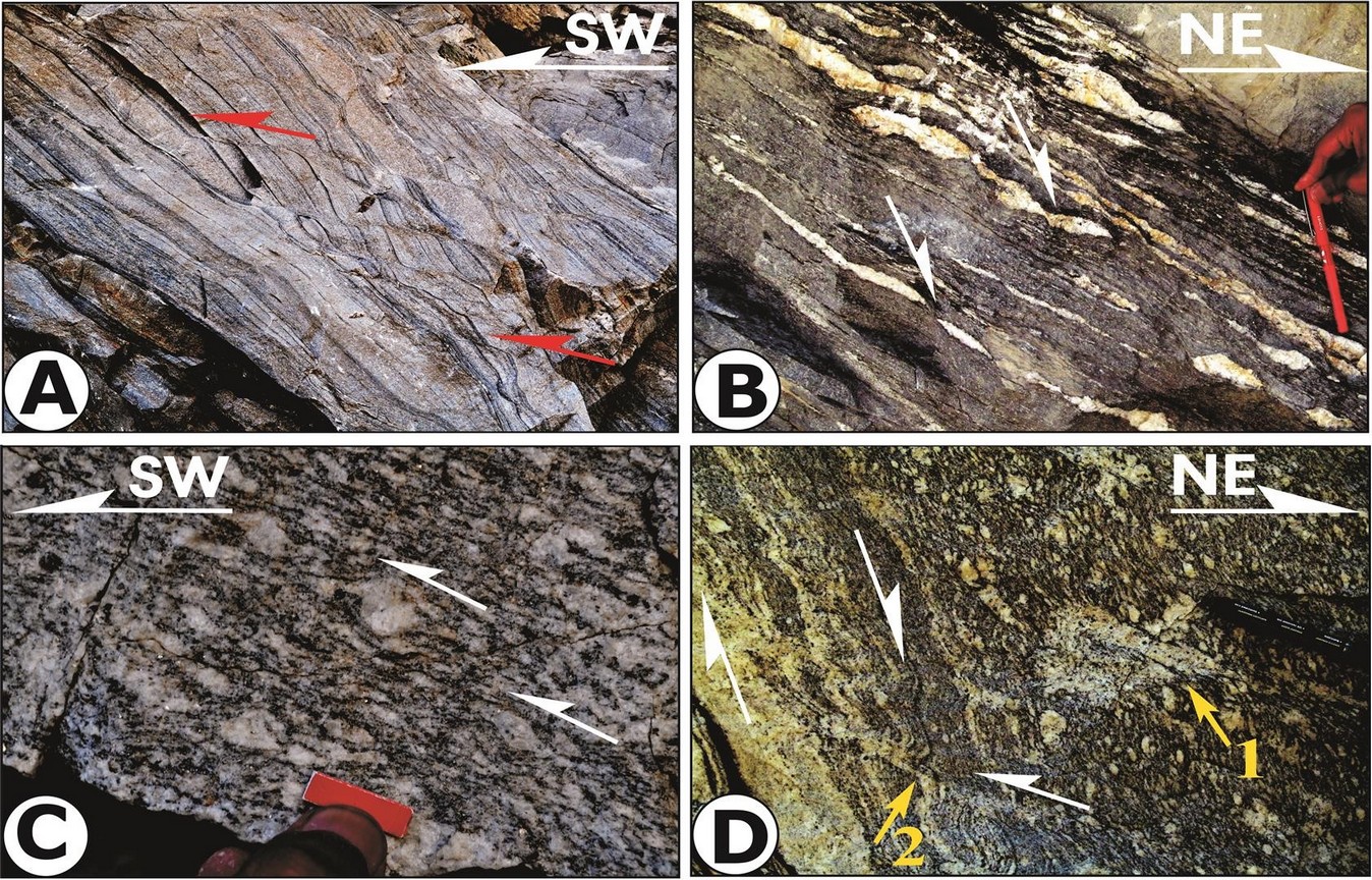
(A) Shear bands exhibiting top-to-the-SW upwards shearing in quartzo-feldsathicg gneiss and schist at Juma. (B) Steep shear bands with top-to-the-NE shear sense, displacing quartz boudins in gneiss at Juma. (C) First appearance of migmatite in the HHC at Stop 20 as porphyroblastic gneiss, showing top-to-the-SW shear sense. (D) Steeply-dipping stromatite migmatite folded by asymmetrical folds verging top-to-the-NE, shown by white arrows. Two new generations of melts observed along axial surfaces (arrow 2) and structureless patches (arrow 1).
Stop. 21.
Location: Before reaching Jelam village. RM-93 (N30o38’22”:E79o49’45”)
Theme: Folded and sheared stromatic migmatites
At this location, stromatic migmatite is folded into NE-verging asymmetrical close to isoclinal folds with enveloping surface striking N3300 and dipping 600NE (Fig. 18A). These are associated with sillimanite (fibrolite)-kyanite-garnet-biotite gneiss/schist, psammitic gneiss/schist. Further up from this location, concordant to discordant pegmatite veins, and small tourmaline-rich leucogranite lenses/dykes make their first appearence (Fig. 18B). Various stages of melt generation and their structural control in the Malari section have been documented by Jain et al. (2013), while this guide book will provide their stop-wise description later as these appear along the traverse.
Further one can also locate northerly-plunging open antiform at Jelam by observing northerly striking metamorphics on left bank of the Dhauli Ganga River.
Figure 18. Migmatite and pegmatite
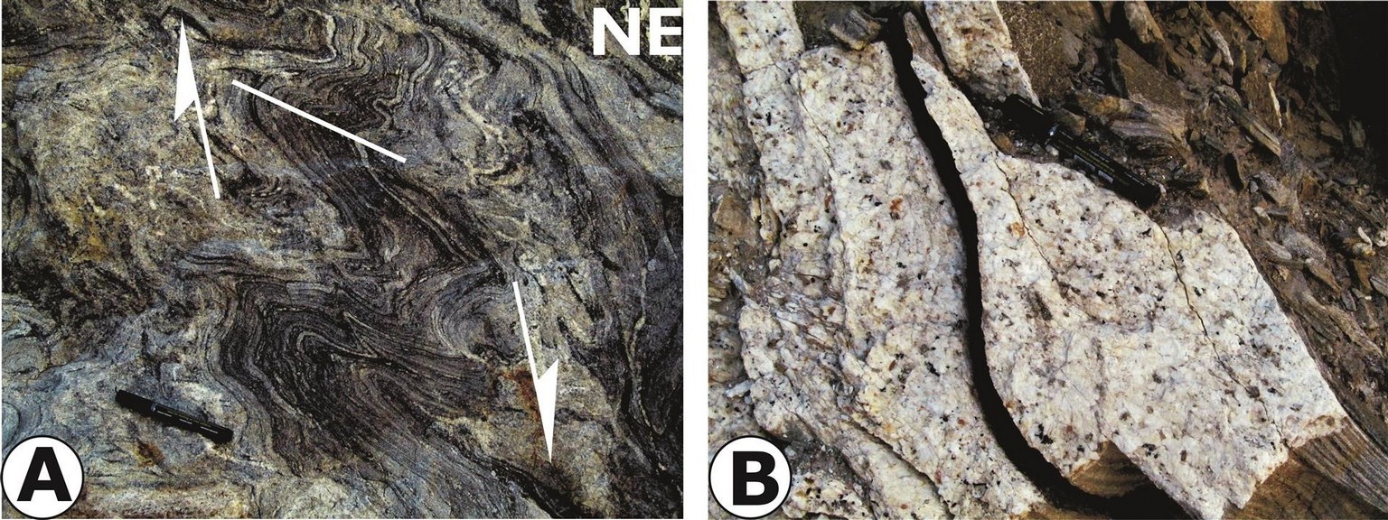
(A) Top-to-the NE downward verging train of folds and migmatitic characters at Stop 21. Scale: Marker pen. (B) Tourmaline-rich large discordant pegmatoidal vein cross-cutting the foliation. Scale: Marker pen. Loc.: About 200 m NE from Stop 21
At the microscale, stromatic migmatites show a spaced sfoliation made by the alternation of lepidoblastic layers of oriented biotite and sillimanite (mainly fibrolitic) and quartzo-feldspathic layers. Mineral assemblage is: biotite, quartz, plagioclase, K-feldspar, sillimanite, garnet and white mica with minor torumaline, zircon, apatite, opaque and monazite. Garnet is subhedral, often inclusion-rich (biotite, quartz, plagioclase), and sometimes has an atollo-like structure (Fig. 19A). It is worth to note that quartz inclusion in garnet and in K-feldspar are rounded or irregular, supporting the melt that was present in such rocks (Waters, 2001). Quartz and feldspar show evidence of dynamic recrystallization, such as lobate grain boundaries, windows and pinning microstructures. Quartz grains show well-developed chessboard extinction pattern (Fig. 19b) suggesting a high-temperature (≥ 650°C) deformation regime in these rocks (GBM II, Stipp et al., 2002a, b). White mica, present in low modal amount, could be subdivided in two different microstuctural groups: i) as larger anhedral grains with intergrowth/inclusion of sillimanite and minor feldspar, ii) as smaller euhedral grains, often cross cutting the fabric (Fig. 19c). The first type could be interpretated as relict of muscovite-involging melting reaction (schematic as muscovite + quartz + plagioclase = sillimanite + k-feldspar + melt), while the second type as a late (retrograde) white mica, forming on cooling/melt crystallisation. More rarely, euhedral feldspar grains are observed in the quartz-feldspar domain (leucosome), again a microstructural support for the migmatic nature of these rocks (Fig. 19d).
Figure 19. Microscopic characters of stromatic migmatite
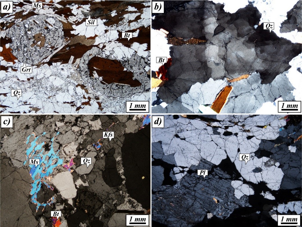
(A) Subhedral atollo-shaped garnet having biotite and quartz inclusions. (B) Anhedral quartz with chessboard extinction. (C) Sieved white mica porphyroblast. (D) Euhedral feldspar in a leucosome
Day 4: Jelam to Malari
We plan to cover mainly the upper formation of the HHC where the Bhapkund Formation has undergone extensive migmatization and produced leucogranite in various phases. We will also observed superposed ductile shearing in the HHC where an earlier top-to-the-SW contractional phase is superposed by younger extensionalphase.
Stop. 22.
Locality: About 1 km before Bhapkund village. RM-95 (N30o39’51”:79o50’50”)
Theme: Syntectonically-grown porphyroblasts and migmatite
Intercalated stromatic migmatite, sillimanite-garnet-biotite-muscovite gneiss/schist and minor calc-silicate bands dip very steeply eastwards. As migmatite becomes pervasive between Stops 21 and 22, we have now entered into the Bhapkund Formation. Mantled porphyroblasts are characterized by reaction rims of mafic and feldspar-quartz mineral aggregates (melt?) surrounding garnet cores (Fig. 20A, see also insert), and are themselves bounded by the S-C foliation; these reveal top-to-the-SW upwards shear sense.
Stop. 23.
Locality: At Bhapkund village. RM-97/RM-21 (N 30o39’55”:E 79o50’29”)
Theme: Melt accumulation in extensional shear bands and necks of boudins.
As we travel through the upper parts of Bhapkund Formation, the lithology remains more or less same, i.e. sillimanite-garnet-biotite-muscovite gneiss/schist and migmatite. At Bhapkund, migmatite within the Formation is typically pervasive with alternating leucosome and mesosome, paralleling to the main foliation Sm (Fig. 20B). The foliations continued to dip in the N-NE direction.
Some beautiful shear bands contain in situ biotite granite melts and dip steeply (50 to 600) towards NE with the top-to-the-NE downward ductile shearing (Fig. 21). A foliation is distinctly visible in these bands, hence these are ductile in character. Interestingly, foliation boudins within the migmatite gneiss are marked by non-foliated leucogranite melt accumulation at their necks and appear to have generated during decompression melting without migration from the place of their generation (Fig. 21; see insert for details).
Stop. 24.
Locality: After crossing the Dhauli Ganga River on Bhapkund Bridge. RM-98/RM-7 (N30o40’00”, E 79o50’30”)
Theme: Deformed garnet, and superposed ductile shearing.
Figure 20. Garnet porphyroblasts and migmatite
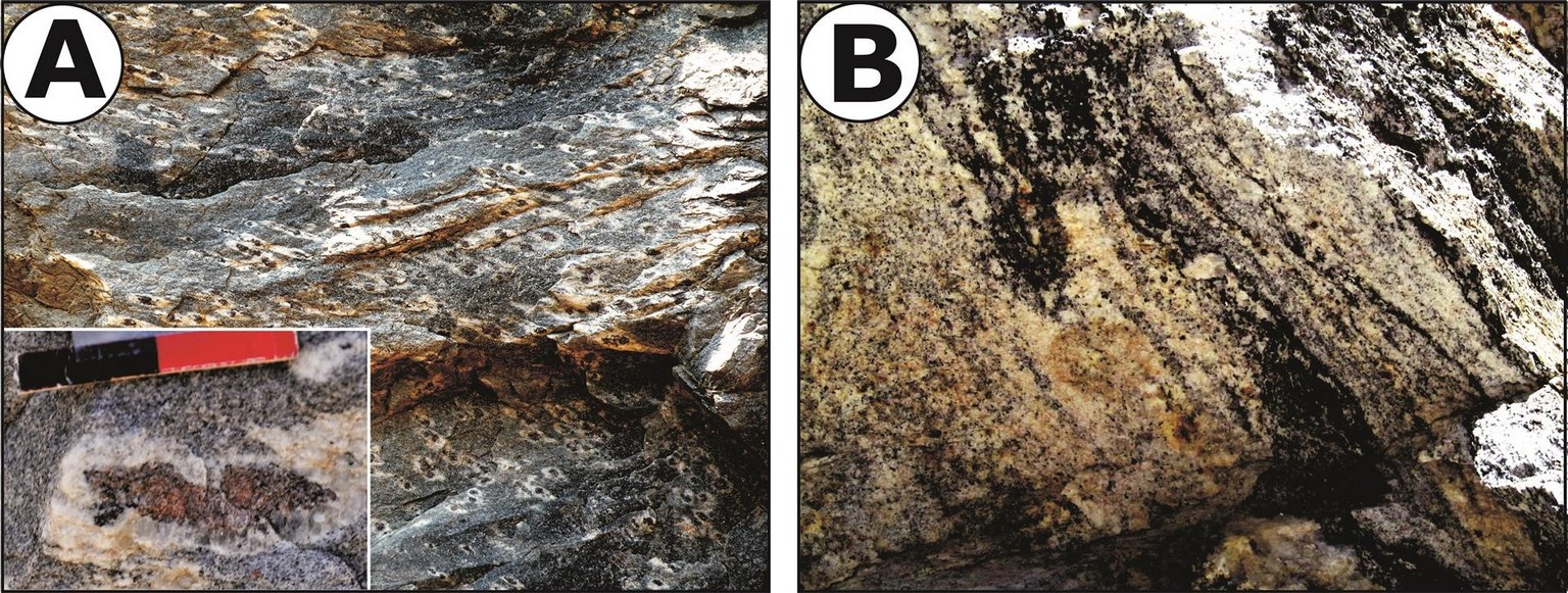
Characters of the Bhapkund Formation. (A) Mantled garnet porphyroblasts rimmed by biotite-rich mafics residues (melanosome), and quartz and plagioclase lucosome fraction developed around large garnets showing asymmetric melt stretching geometries (see insert) with top-to-the-SW-upwards shear sense. Stop. 22. Scale: Photograph width is about 8 cm. (B) Pervasive stromatite migmatite having leucosome and mesosome parallel to main foliation Sm
Figure 21. Extensional shear bands and foliation boudins with leucogranite
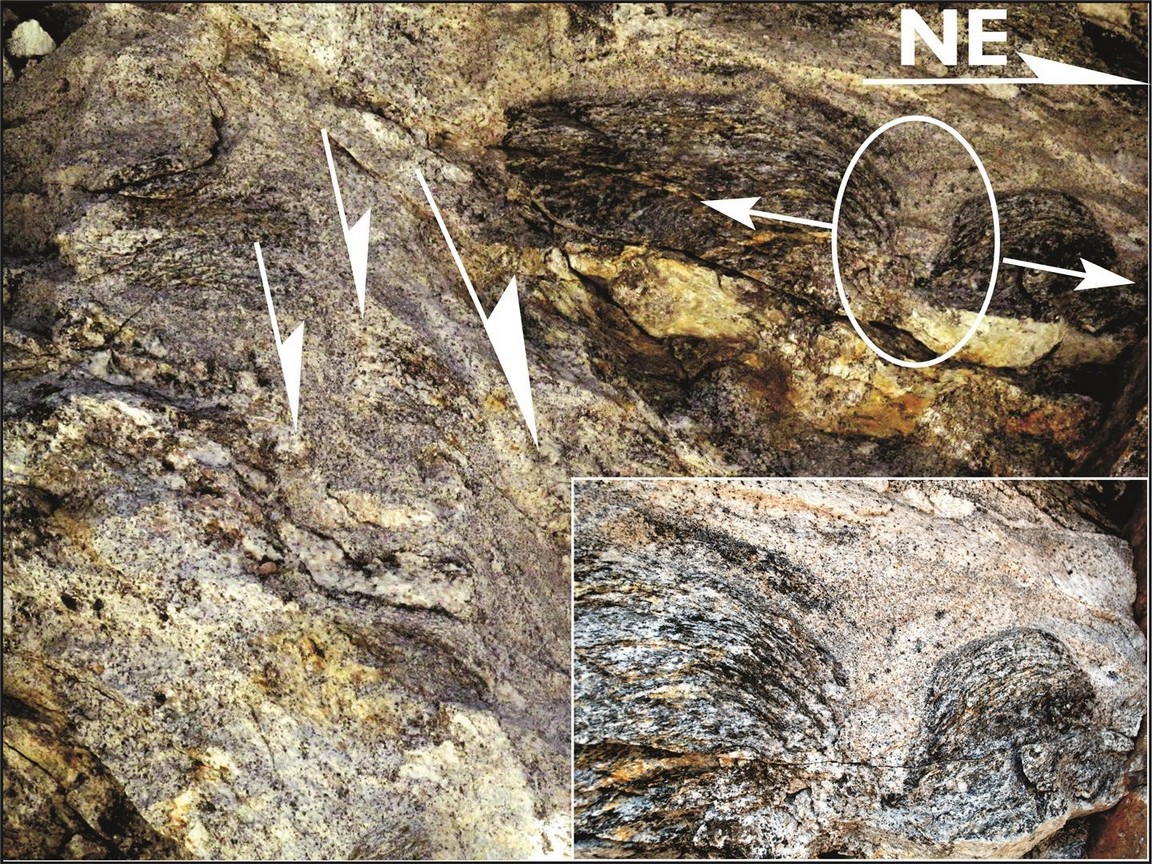
Two-stage melt generation and their accumulation along steeply-dipping extensional shear bands and necks of extensional foliation boudins (insert). Stop 23
After crossing the Dhauli Ganga River on the Bhapkund Bridge, some rare garnet porphyroblasts are marked by filled ‘V’-shaped gaping cracks, which are asymmetrically oriented and taper downwards (Fig. 22A). Individual larger grains still remain intact, but smaller fragment appears to have moved upwards, and provides indisputable evidence of top – to – SW (thrust) shear sense (Hippertt, 1993). Further along the main road, stromatite migmatite are isoclinally folded whose hinges are still preserved as rootless fold due to intense top-to-the-SW upwards ductile shearing (Fig. 22B). Interestingly, this ductile shearing is superposed by another but younger phase of top-to-the-NE downwards shearing (Fig. 22B).
Figure 22. “V pull-apatrs” and superposed shearing
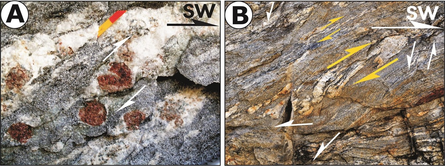
(A) ‘V’-pull-apart in garnet from the HHC along the Dhauli Ganga Valley. Arrow points top-to-the-SW upwards. Stop 24. Scale: 2 cm. (B) Top-to-the-NE ductile shear bands superposed on rootless isoclinal folds, transposed along top-to-the-SW ductile shear zones. Stop 24. Scale: Length of photo ~2 m
Stop. 25.
Locality: Almost halfway between Bhapkund Bridge and opposite Kosa village on the main road. RM-99/RM-8 (N30o40’10”:E 79o50’47”)
Theme: Youngest leucogranite pods and veins
Main foliation within the fine-grained biotite-rich gneiss is overprinted by structureless small patches of leucogranite lacking and structural fabric (Fig. 23). Incipient melt has possibly generated along the main foliation and migrated into zones of least pressure for accumulation into pods.
Figure 23. Structureless leucogranite patches
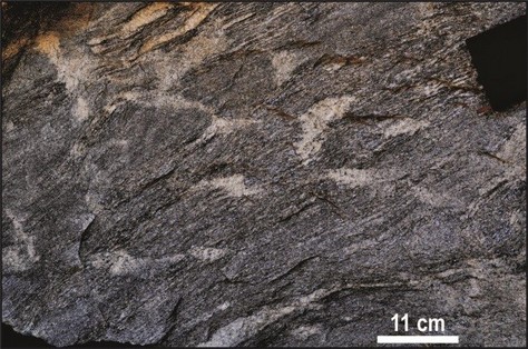
Structureless discordant and isolate leucogranite patches overprinting main foliation. Stop 25
Stop. 26.
Locality: On the main road opposite Kosa village. RM-100/RM-10 (N30o40’20”: E79o51’24”)
Theme: (i) Pegmatoidal granite along shear zone, and (ii) extensional shear zone.
Foliated and fine-grained biotite-rich gneiss is intruded by undeformed tourmaline-bearing pegmatoidal granite along an extensional shear zone exhibiting top-to-the SW downward movement (Fig. 24A).
Within about 300 m distance from Stop 26 (RM-100), fine-grained biotite-rich gneiss is sigmoidally folded by a series of top-to-the-NE extensional shear zones which are smeared by thin plates of sillimanite layers and fibrolite needles (Fig. 24B). These zones strike almost NW and dip 45 to 500 NE. Top-to-the-NE downwards extension shear zones dominate in this area and are either sillimanite-bearing or intruded by granitic melt.
Stop. 27.
Locality: About 2 km before Malari on the main road. RM-105 (N 30o40’52”:E79o53’30”)
Theme: Typical mylonites associated with the South Tibetan Detachment System (STDS).
Figure 24. Pegmatite and sillimanite-bearing shear zones
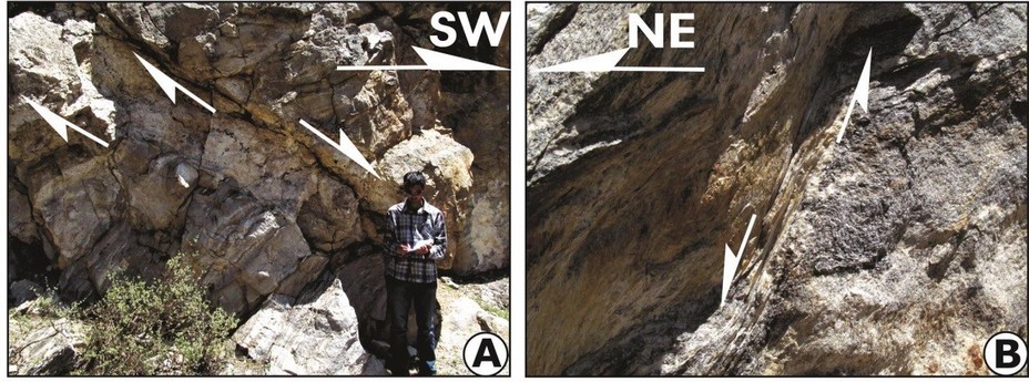
(A) SW-dipping tourmaline-bearing pegmatoidal granite along a shear zone. Stop. 26. (B) NE-dipping steep shear zones marked by well-developed sillimanite plates about 300 m from Stop 26 (Loc. RM-101)
In this stop the high-grade rocks of the HHC are strongly overprinted by ductile shearing related to the STDS activity. At the outcrop scale well-developed mylonites with a top-to-the-North sense of shear can be observed (Fig. 25A) along with pods of sillimanite, pseudomorphosed on kyanite.
At the microscopic scale these rocks have a spaced foliation with alternating granoblastic layers of quartz and plagioclase and biotite rich layers (Fig. 26B). Kyanite and garnet porphyroclasts are observed in such rocks, and is worth to note that sillimanite needles are aligned on the main foliation (Fig. 25B). Well-developed kinematic indicators such as kyanite fishes, C’ shear bands also confirm the top-to-the north sense of shear affecting these rocks.
Day 5: Around Malari
This day is dedicated to the detailed study of the South Tibetan Detachment System (STDS) where its deformational imprints on the HHC and the Tethyan lithologies are clearly observed as both the ductile and brittle shear zones and related structures.
Stop. 28.
Locality: Malari village and adjoining areas. RM-28A: Above Kishanpur (N30o45’00”: E79o53’ 13”). RM-28B/RM-14: On road (N30o42’32”:E79o52’52”). RM-28C/RM-2: On road (N30o41’37”:E79o53’00”). RM-28D/RM-A: On road (N30o41’00”:E79o53’00”). RM- 28E: On road (N30o40’ 57”:79o53’45”)
Theme: Investigating the South Tibetan Detachment System (STDS).
Moving towards Malari village just after crossing a small temple, one can see the Malari leucogranite. It is very narrow and unmappable on 1:50,000 scale and poorly exposed and mostly confined within the HHC. Though a few pegmatite bodies are observed withinthe Martoli Formation near Niti village, most of these do not cut across the Martoli Formation (Jain et al., 2013).
Figure 25. Typical mylonite along the STDS and shear sense indicators.
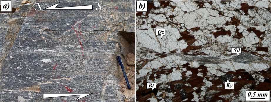
(A) Outcrop of the HHC gneiss strongly overprinted by STDS shearing. (B) Kyanite fish and sillimanite needles at the microscale
First appearance of low grade Martoli rocks along the STD can be appreciated at the northern boundary of the Malati village. The STDS separates the low grade Martoli Formation of the THS from the high grade Bhapkund Formation of the HHC (Fig. 26). The Martoli Formation is constituted by low-grade quartzite and meta-arenite interbedded with metapelites. In the quarzitic layers, walking along the small river NE of the village, primary sedimentary structures, such as crossed bedding, are still recognizable (Fig. 27a). At the microscale a fine continuous foliation can be distinguished in the more pelitic levels associated to the dynamic recrystallization of illite (Fig. 27B). Undulatory extinction in quartz is predominant and the development of very small new grains could indicate a bulging recrystallization (BLG, Stipp et al., 2002a, b). Dynamic recrystallization is accompanied also by pressure solution mechanism that gives rise to brownish seams made by oxides and insoluble materials (Fig. 27B).Minor shape preferred orientation of detrital micas is present in the arenaceous levels.
From the Malari village, one can clearly see a nice view of the STDS contact (Fig. 28 A) separating the steeply-dipping HHC and the gentle THS (Figures 28A, B). After crossing the Malari village going further northwards, one can observe normal faults with their fault gouge zones with intense brittle fracturing and cataclasis in the HHC (Fig. 28C). These are the field evidences of extensional brittle deformation caused due to the STDS. As we can see from Figure 28D there is sharp change in lithology from highly deformed
Figure 26. Geological map of the Malari area
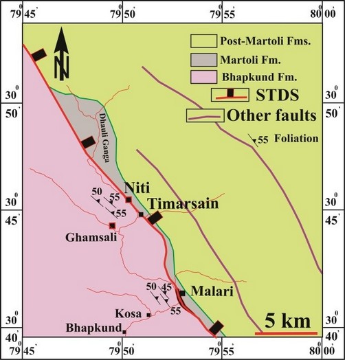
Simplified geological map of the Malari area separating the high grade HHC from the Tethyan Himalayan Series.
Bhapkund gneiss, the Malari Granite and the Martoli Formation. The STDS contact is not exposed at the Malari village. Many brittle faults dissect the Malari Granite, having subhorizontal geometry (Fig. 28E(i)) unlike the shear zones within the uppermost Bhapkund Formation. This has been possibly caused by the rollover antiformal disposition of the granite vis-à-vis the STDS.
Both type of shear sense indicators are observed within the Malari granite. Fig. 28E(ii) shows the presence of older top-to-the SW upwards structures over which younger top-to-the NE downward structures are superimposed (right bottom of the Fig. 29E(ii)). But after crossing the Malari village while moving towards Ghamsali only top-to-the NE downwards structures were observed within the Martoli Formation (Fig. 28Eiii).
Ductile structures in the Malari Granite at the mesoscale are represented by S-C-C’ fabric (Fig. 29A) and asymmetric feldspar porphyroclasts. At the microscale mica fishes, pointing to a top-to-the North sense of shear, are well developed. Mica fishes can be mainly referred to type I of Passchier and Trouw (2005) (Fig. 29B).
Figure 27. Structures and microtextures of the Martoli Formation.
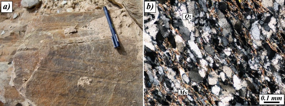
(A) Cross-bending lamination in quartzite of the Martoli formation. (B) Microscopic aspect of quartzite form the Martoli Formation showing a prominent S1 continuous foliation.
Quartz shows a bimodal distribution and a strong shape preferred orientation. Quartz presents undulatory extinction, subgrains (often very elongated) and new grains are commonly observed, suggesting a combination of bulging/subgrain rotation ecrystallization mechanism, indicating a deformation temperature of c. 400-430°C (Stipp et al., 2002a, b). K-feldspar is fractured and show quartz recrystallization in the fractures (Fig. 29C). Tourmaline grains are often broken with fractures orthogonal to the mineral elongation, filled by quartz and blue tourmaline overgrowth on the former one. Brittle structures, such as intergranular fractures, superimposed on the ductile solid state deformation are observed, also at microscale in the Malari granite (Fig. 29D). Both macro and micro scale observations strongly disprove the previous conclusions of Sachan et al. (2010) regarding the Malari leucogranite like a magmatic body cross-cutting the STDS, (in the Garhwal region) at c. 19 Ma. Up to now, the only undeformed granite clearly intruding both HHC and TSS is the Bura Buri granite in Western Nepal (~ 24 Ma; Carosi et al., 2013).
Day 6: Malari - Niti
Last day of the traverse covers parts of the STDS along the strike towards NW between Malari and Niti village along the picturesque upper parts of the Dhauli Ganga Valley, where the uppermost parts of the HHC are exposed along this important tectonic boundary. One can observe different melt phases related to the leucogranite accumulation, superposed shear senses within uppermost parts of the HHC and deformation related to the STDS.
NOTE: GPS Locations beyond this point could NOT be recorded due to restrictions. Please refer the map (Fig. 1) for approximate location.
Figure 28. South Tibetan Detachment System (STDS) near Malari
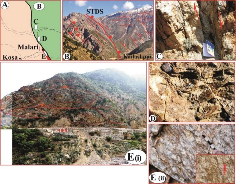
(A) Local geological map of the STDS showing various structures in its vicinity near Malari. (B) The STDS above Kailashpur, observed from Malari. Steeply-dipping HHC gneiss (left) is tectonically overlain by gently-dipping Martoli Formation. Unfilled rectangles indicate small-scale faults. Dash lines are traces of joints. (C) Normal fault and its fault gouge and breccia within leucogranite due to isolated splay extensional fault of the STDS. About 4 km from Malari on the Malari-Niti road. (D) The Martoli quartzite deformed by brittle-ductile extensional fault zone near Malari. Scale – Pen. (e i), Overall fracture pattern in deformed granite with thrusts, normal faults and joints at Malari village. Loc. (e ii), Insert shows details of subhorizontal thrust. (e iii) Porphyroclastic Malari granite having asymmetrical megacrysts having top – to – SW (arrow) overthrust sense, and shear bands with top – to – NE downward shear sense on the road near the village Malari, thus indication of the presence of both relict and younger kinematic indicators. Scale: 5 cm
Stop. 29.
Locality: West of Kailashpur on the Malari-Niti Road. Loc. RM-15
Theme: The South Tibetan Detachment System (STDS), its deformation and stages of granite melts
Figure 29. Deformed microtextures of the Malari Granite.
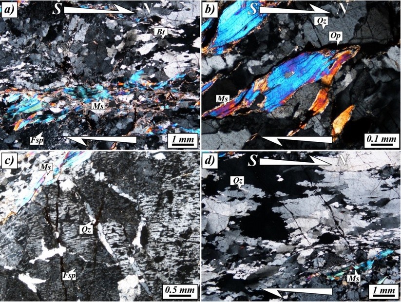
(A) Deformed Malari leucogranite. (B) Details of white mica fish pointing a top-to-the North sense of shear. (C) Quartz filled fractures in feldspar. Note also late intergranular fractures.(D) Dynamic recrystallization of quartz. Note the late intergranular fractures
Further north from Malari and to the west of Kailashpur village, a few fresh cuttings on the road to Niti, the HHC metamorphics as grey paleosome are intimately interbanded with pervasive leucogranite neosomes; both having concordant foliation S1 (Fig. 30A). This is the indisputed evidence that the leucogranite started generating much earlier in the HHC, though the age of this phase of magma generation remains unconstrained. Within the nearby exposure, the HHC exhibits asymmetrical feldspar megacryst and is surrounded by S-C shear fabric; both exhibiting top-to-the-SW ductile shearing (Fig. 30B).
Stop. 30.
Locality: Between Ghamsali and Timarsain. RM-17
Theme: The HHC, its deformation and stages of granite melts
The Dhauli Ganga River flows through picturesque glacial valley till Bampa where an important tributary Amrit Ganga meets from the northwest. After the beautiful terrace at Ghamsali the Dhauli Ganga cuts a very steep gorge till Timarsain through sillimanite-bearing gneiss. Tight to isoclinal transposed F2 folds upon stromatic migmatite verging towards SW are affected by thrusts on limbs with their surfaces marked by new leucosomes (Fig. 31A). Top-to-the-SW ductile shear sense within 1.5 km of the STDS is
Figure 30. Oldest migmatite and shear sense indicators in the HHC.
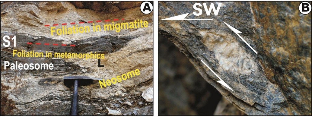
(A) Pervasive and concordant paleosome and neosomes within the upper parts of the HHC at Stop 29. Note parallel foliation S1 in metamorphics and foliated leucogranite. (B) Asymmetrical σ-shaped feldspar porphyroclast surrounded by S-C shear fabric.
decipherable from these folds and thrusts. However, within few meters, ductile shear zones having top-to-the-NE shearing are also encountered where both the leucogranite and the country rocks become foliated (Fig. 31B). Late stage cross-cutting undeformed, large and tourmaline-bearing leucogranite veins and apophyses manifest the terminal stage of the melt segregation and magmatic emplacement within the HHC.
Stop. 31.
Locality: Timarsain. RM-20
Theme: Ductile shearing due to the STDS
The Dhauli Ganga River cuts through almost vertical gorge between Ghamsali and Timarsain in the uppermost parts of the HHC. One of the best exposures of the deformation caused by the STDS is observed at Timarsain where the Dhauli Ganga River takes a L-shaped turn and opens up into the wide Niti valley after its junction with the Shalshal Nala. Megacrystic granite gneiss of the uppermost part of the HHC reveals an early top-to-the-SW shear sense from the asymmetrical feldspar (marked by red arrows), superposed by shear bands, S-C shear fabric and asymmetrical rotated feldspar indicating younger top-to-the-NE ductile shearing (Fig. 32B). Some of the fault surfaces are strongly striated to produce late-stage steeply-plunging lineation (Fig. 32D). While looking NW across the Dhauli Ganga River from the same locality one finds evidences of
Figure 31. Deformation of the HHC and stages of granite melts
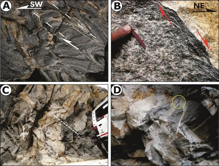
(A) SW-verging thrusts and isoclinal folds of stromatic migmatite. Note new leucosome along thrusts. (B) NE-shear sense from normal ductile shear zone having new shear fabric. (C) Cross-cutting leucogranite veins across F2 folds in HHC metamorphics. (D) Leucogranite apophyses from main vein and development of xenoliths
brittle to brittle-ductile superposed duplexes showing top-to-the NE shear sense along the STDS (Fig. 32C).
Stop. 32.
Locality: Beyond Niti village. RM-19
Theme: Tethyan Sedimentary Sequence and leucogranite
Further travelling along the road connecting Niti village, one starts observing exposures of the low grade metamorphosed Martoli Formation on the hanging wall of the STDS, where these muscovite-biotite schist and quartzite with detrital quartz grains are intruded by irregular and foliated leucogranite (Fig. 32A). The Martoli Formation strikes N3000 and dips about 500 towards NE. These are cut by very steeply-dipping normal faults striking N-S dip of about 750 towards E. Our mapping reveals that the STDS runs parallel to the NW-SE trending Dhauli Ganga River between Timarsain and Niti village.
Figure 32. The South Tibetan Detachment System (STDS) around Niti.
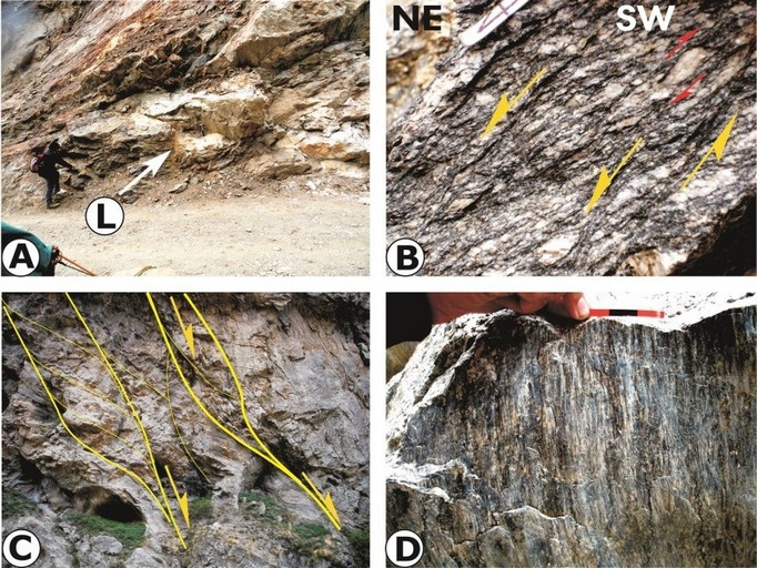
(A) Muscovite-biotite schist and quartzite of the Martoli Formation on the hanging wall of the STDS intruded by irregular and foliated leucogranite. Stop- Above Niti village. Scale: Hammer. (B) Megacrystic granite gneiss of the uppermost part of the HHC showing both top-to-the-SW asymmetrical feldspar, superposed by shear bands, S-C shear fabric and asymmetrical feldspar indicating top-to-the-NE ductile shearing. Location: RM-20. (C) Steep NE-dipping brittle-ductile shear zones causing development of normal duplexes paralleling the STDS. On opposite hill face of Timarsain. Location: RM-20A. Scale: Photo about 10 m. (D) Striations along a fault showing thrust geometry at Timarsain. Location: RM-20. Scale 3 cm.
