Introduction
This paper describes a geological field trip along the Numbur Cheese Circuit (NCC) in the central-eastern Nepal Himalaya (Fig. 1A); the guide is intended not only for geologists but also for trekkers interested in the geological and natural aspects of the area. The NCC, located ca. 200 km east of Kathmandu in the Ramechap district, has been only recently promoted and developed as a trekking route in Nepal and is therefore quite unknown to both trekkers and geologists. It is named in honor of the Numbur Chuli peak (6959 m) and of the famous yak-cheese produced in the local workshops. The NCC is at the south-east termination of the Rolwaling region and connects two major valleys: the Khimti Khola to the west and the Likhu Khola to the east. These two valleys are also crossed by the Jiri to Lukla trekking route at Shivalaya and Kinja, respectively (Fig. 2).
Figure 1. Tectonic sketch map of the Himalaya and schematic cross-section
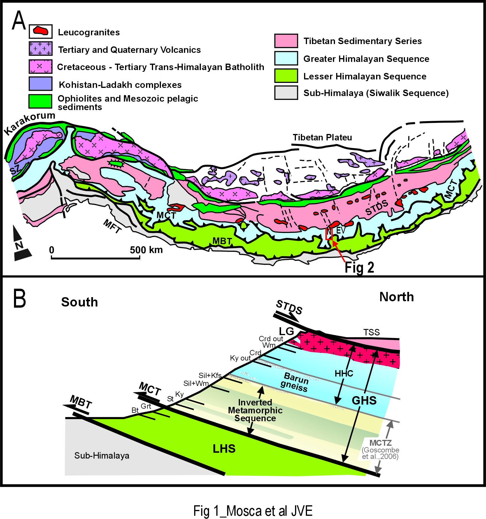
(A) Simplified tectonic sketch map of the Himalaya (redrawn after Dietrich and Gansser, 1981). The location of Fig 2 is reported. (B) Schematic cross-section across the central-eastern Himalaya (modified from Goscombe et al., 2006 and Searle et al., 2008). EV, Everest; LG, leucogranites; LHS, Lesser Himalayan Sequence; MBT, Main Boundary Thrust; MCT, Main Central Thrust; MCTZ, Main Central Thrust Zone; MFT, Main Frontal Thrust; N, Numbur; STDS, South Tibetan Detachment System; SZ, Indus/YarlungTsangpo Suture Zone. Mineral abbreviations are after Whitney and Evans (2010).
Figure 2. Tectonic sketch map
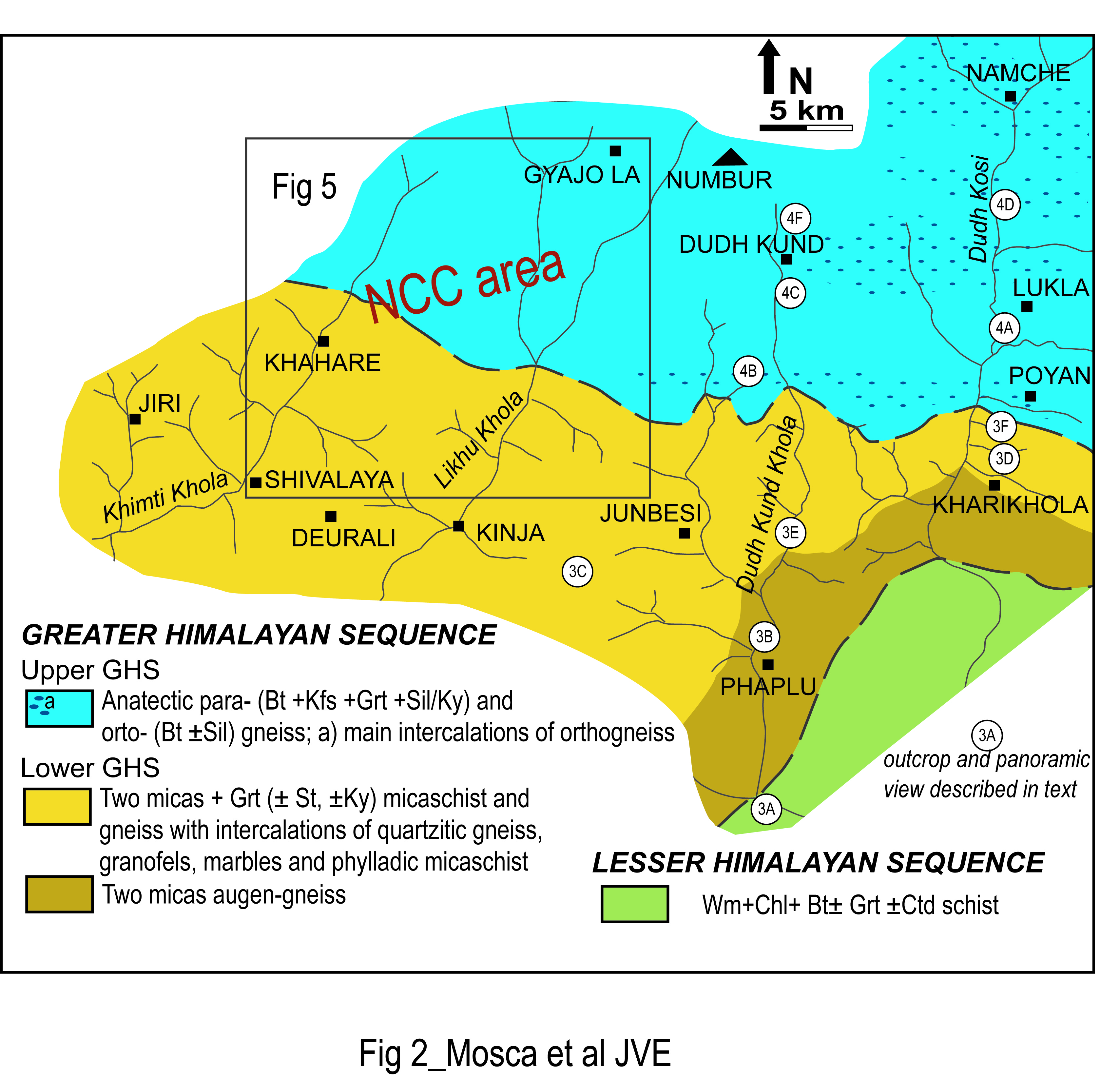
Tectonic sketch map of the area between the Khimti Khola valley to the west and the Dudh Kosi valley to the east. Location of the representative outcrops shown in Fig. 3 and Fig. 4 is reported. The area crossed by the NCC (located between the Khimti Khola and the Likhu Khola valleys) is detailed and illustrated in the proposed itinerary (Fig. 5).
The area of the NCC has been investigated by the authors of this paper in the framework of extensive geological field studies across the east-central Himalayan orogen (e.g. Groppo et al., 2013; Mosca et al., 2013). A 11-days geological field trip along the NCC is proposed on the basis of personal experience of the authors. The itinerary runs clockwise, beginning and concluding at Shivalaya, a village located in the Khimti Khola valley. This village can be reached after a 8 hour drive from Kathmandu and its tourist information-point and market allow also to ultimate trek logistics.
Following a general description of the Himalayan chain, this paper introduces the NCC at a regional scale describing main geological features of the area extending from the Khimti Khola to the west to the Dudh Kosi to the east; for this scope, a few representative images are illustrated along classical Jiri to Lukla and Dudh Kund trekking-routes.
Then, in the second part of the paper, the most peculiar geological aspects of the area between the Khimti Khola and the Likhu Khola valleys are introduced through observations of selected outcrops, samples and view-points along the NCC.