Introduction
The southern half of the Himalayan thrust belt is composed of low-grade metasedimentary and sedimentary rocks that are collectively referred to as the Lesser Himalayan sequence. Although the low elevation and relatively humid climate in the Lesser Himalaya combine to limit outcrop exposures (relative to those of the high elevation Greater Himalaya), careful mapping accompanied by geochronology and isotope geochemistry allow the recognition of regional stratigraphy and structural geology. Thermochronology, in the context of regional balanced structural cross-sections, helps to establish the kinematic history and tectonic evolution of the thrust belt.
A geologic map of far-western Nepal was first compiled at a scale of 1:250,000 by Shrestha et al. (1987a, 1987b), illustrating the major stratigraphic packages and fault zones. Upreti (1996, 1999) compiled the work of previous researchers in central and western Nepal and showed the correlation of stratigraphy between the two regions. The work of DeCelles et al. (1998a, 2001) and Robinson et al. (2001, 2003) provided additional stratigraphic and structural data for the large-scale study presented in Robinson et al. (2006) that includes a map and three cross-sections. Pearson & DeCelles (2005) documented the stratigraphic and structural context of the Ramgarh thrust (Fig. 1), which was then extended across the whole Himalayan arc in Robinson & Pearson (2013) and referred to as the Ramgarh-Munsiari thrust. The three cross-sections were forward modeled in Robinson (2008), providing a clear picture of the structural evolution of the Himalayan thrust belt. DeCelles et al. (2001) and Robinson et al. (2001, 2006) used a combination of cross-cutting relationships and the detrital unroofing record of Miocene-Pliocene foreland basin deposits to develop a kinematic history in far-western Nepal. However, thermochronologic data needed to assess the history of rock exhumation in far-western Nepal are still sorely lacking (e.g., Robinson et al., 2006). Bollinger et al. (2004) provided important thermal constraints on Lesser Himalayan rocks using Raman spectroscopy of carbonaceous minerals (RSCM) data. The foreland basin deposits in front of the Himalayan thrust belt were dated using magnetostratigraphy (Appel & Rösler, 1994; Rösler et al., 1997; Gautam & Rösler, 1999; Gautam et al., 2000; Ojha et al., 2000, 2009) and a temporally constrained shift in the carbon isotope composition of organic matter (Ojha et al., 2000, 2009) and tied to periods of time when the thrust belt was deforming and eroding (e.g., DeCelles et al., 2001; Huyghe et al., 2001; Mugnier et al., 2004; Najman et al., 2004, 2009; van der Beek et al., 2006; Szulc et al., 2006; Ravikant et al., 2011). Robinson & McQuarrie (2012) used forward modeling reconstructions and these data in the thrust belt and foreland basin to tie the erosional unroofing and associated deposition to the kinematics and age of fault motion. Thus, western Nepal provides a testing ground in the Himalaya for assessing structural models and the evolution of the thrust belt.
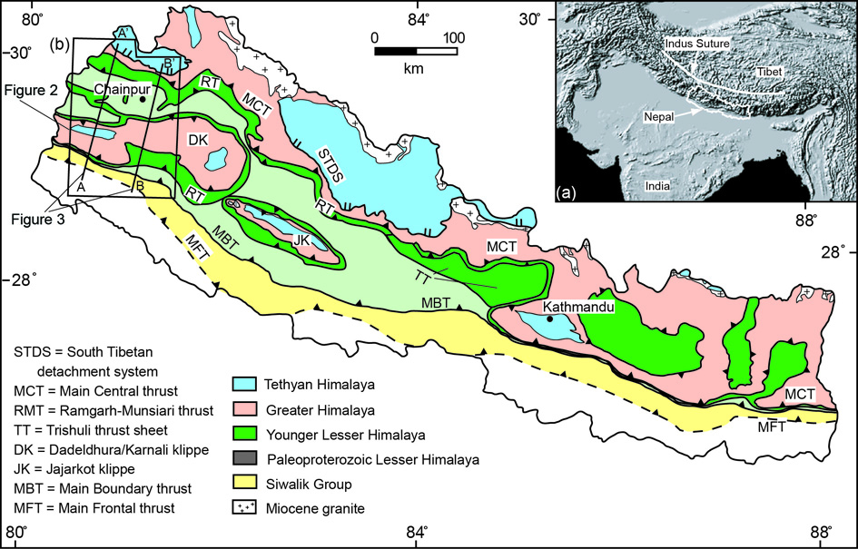
Figure 1. The Himalayan-Tibetan orogenic system and geological map of Nepal
a) Digital Image of the Himalayan-Tibetan orogenic system from the Global 30 Arc Second Elevation Data Set. Nepal is outlined in white for reference. (b) Geologic Map of Nepal modified from Robinson & Pearson (2006) and loosely based on Amatya & Jnawal (1994). Black box outlines the geologic map in Figure 2. Cross section lines from Robinson et al. (2006) are marked by two parallel black lines and are shown in Figure 3. Thrust faults are indicated with barbs. Normal faults are indicated with two small parallel lines. Cities are indicated with a solid black circle.
The purpose of this paper is to provide a unifying view of the Himalayan thrust belt in far-western Nepal (Fig. 1) via a virtual field trip that highlights key regions for stratigraphic and structural insights. Figure 2 is a generalized version of the geologic map from Robinson et al. (2006) and marks key locations detailed in this manuscript. Figure 3 shows two cross-sections that illustrate the structural geology. Remote far-western Nepal does not have a well-developed hostelry infrastructure. Thus, the first half of this field trip may be accessed by road with camping but the second half can only be accessed by hiking and camping. On May 2, 2000, GPS errors instantaneously changed from 100 m to 10 m; thus, some of the GPS locations acquired before this change may have errors of up to 150 m.
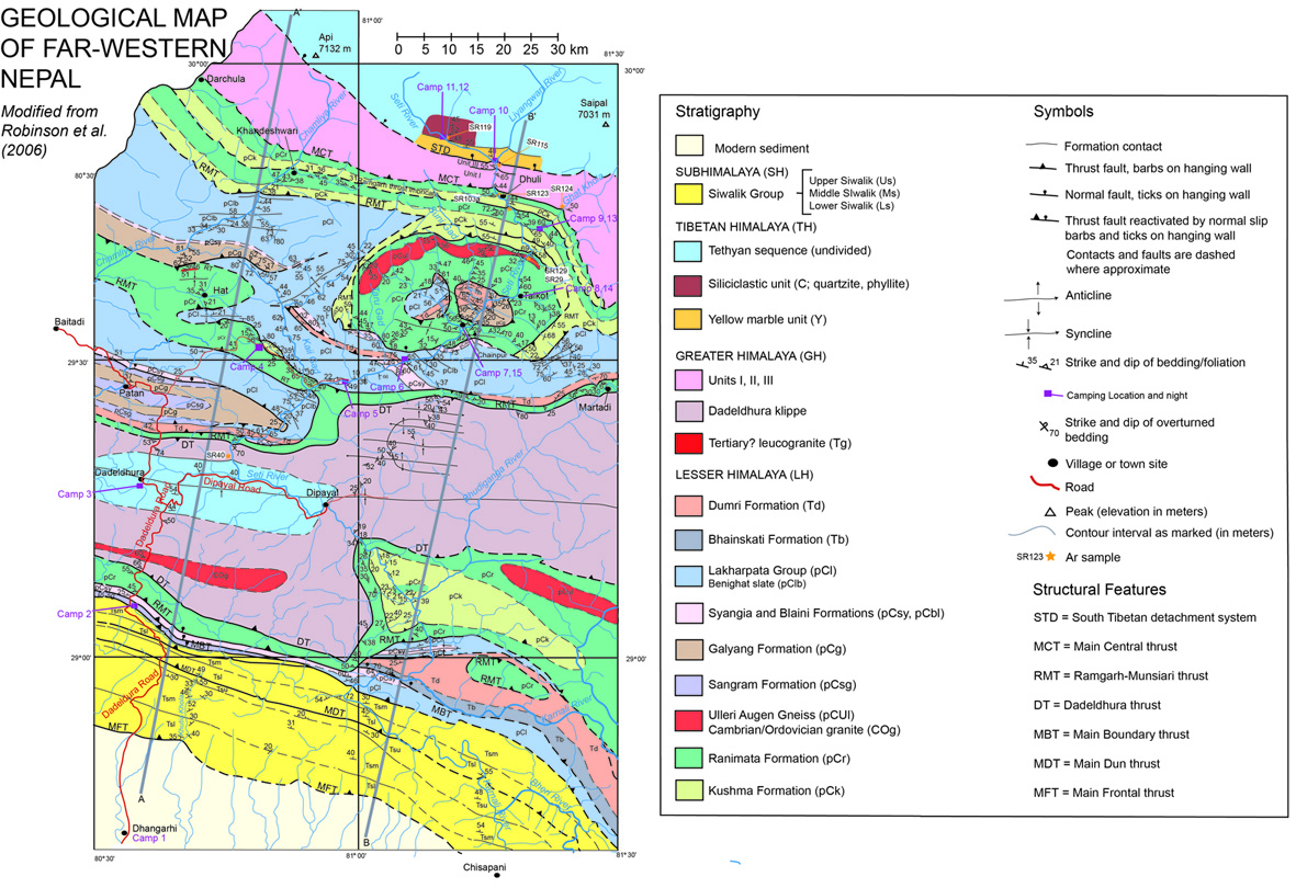
Figure 2. Western Nepal Map
Western Nepal Map with camp locations and photos modified from Robinson et al. (2006).