DAY 8. Chainpur to Talkot
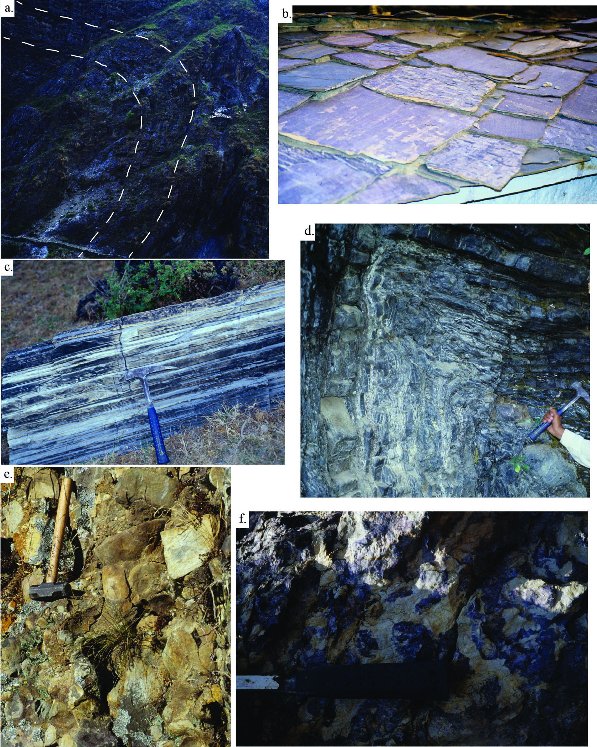
Chainpur is located in the Ranimata Formation. However, within that formation there are significant quartzite interbeds. Figure 11a is a picture of folded quartzite beds located on the mountain on which Chainpur is built. Hiking northeast along the Seti River, you will pass out of the lower LH thrust sheet and into a window through the thrust sheet. In that window, you will see a hut along the trail with Syangia Formation slate purple roof tiles (Fig. 11b) and then on the west side of the river you will find laminated dolomite of the Baitadi carbonate rocks in the Galyang Formation (Fig. 11c) (N29º34’45.6”; E81º14’04.5”; 1310±150 m). The Bauli Gad is the river that flows into the Seti River from the north and there are exposures of the Gondwana sequence up this river (Fig. 11d). The Lesser Himalayan units described below are not in stratigraphic order but are arranged as they are encounterd along the Seti River.
Figure 11. Kushma and Syangia Formation, Baitadi Carbonates, Amile and Dumri Formations

a) Fold in the Kushma Formation quartzite near Chainpur (N29°34’21.3”; E81°10’ 24.5”; 4700’). Trail at the bottom of the picture for scale. (b) Purple slate of the Syangia Formation make for appropriate roof tiles, NE of Chainpur (N29°35.195”; E80°13.918’; 4747±492’). (c) Black and white banding in the Baitadi Carbonates of the Galyang Formation, northeast of the town of Chainpur. Rock hammer is 0.3 m long (N29°35’30.7”; E81°13’ 42.9”; 5513±73’). (d) Interbedded black shale and quartzite in meso-scale fold in the Amile Formation of the Gondwana sequence. Om Pashad’s arm and hammer for scale (N29°35.934’; E81°12.752’; 4795±240’). (e) Quartz pebble conglomerate with purple sandstone matrix in the Dumri Formation. Rock hammer for scale. Clasts are up to 10 cm in diameter (N29°35.811’; E81°13.197”; 5304±315’). (f) Dumri Formation Oxisol. Yellow patches are kaolinite and purple areas are hematitic. This is a paleolateritic soil. Hammer end for scale (N29°35’ 29.3”; E81°14’36.7”).
Gondwana Sequence
Resting unconformably on top of the Lakharpata Group in far-western Nepal is a several-hundred-meter thick succession of clastic sedimentary rocks of probable Late Cretaceous age that is readily assigned to the so-called Gondwana sequence. In central Nepal this succession also contains upper Carboniferous, Permian, and lower Mesozoic strata and have been studied in some detail by Sakai (1983, 1985, 1989). Additionally in central Nepal, the Gondwana sequence is an interval of quartzose sandstone, black shale, coal, lignite, and quartz pebble conglomerate. In far-western Nepal, the Gondwana sequence is poorly exposed. The main rocks consist of pebbly quartzose conglomerate and conglomeratic sandstone, black shale, and lignite.
Dumri Formation
Disconformably overlying the Bhainskati Formation is the lower Miocene Dumri Formation (Sakai, 1983; DeCelles et al., 1998b). Several kilometers north of Chainpur on the Bauli Gad and Suni Gad (Fig. 11e), a thick pebble conglomerate crops out in the Dumri Formation. The variegated cobble quartzite clasts and rosy quartz grains in the sandstone matrix suggest a semi-proximal location in Early Miocene time to the Himalayan thrust belt. It is possible that this conglomerate is older than the ~20 Ma at Chainpur. These outcrops north of Chainpur are the farthest north occurrences of this synorogenic sedimentary unit.
Continuing northeast along the trail along the Seti River east of Chainpur (Fig. 2), the lower half of the Dumri Formation is a green strongly indurated micaceous sandstone. At the base of the section, mottled purple and while bauxite paleosols (Fig. 11f) contain mainly kaolinite and hematite pisolites indicating a humid environment (N29º35’29.3”; E81º14’36.7”), similar to the paleosol that separates the Bhainskati and Dumri Formations at Dumri bridge. This disconformity is present along the entire Himalayan orogenic belt, and represents up to 15-20 myr of geologic time (DeCelles et al., 1998b). The upper half of the formation is dominated by red and green shale. Detrital white micas provide an 40Ar/39Ar age from the lower micaceous sandy section of ~20 Ma, which establishes the maximum age of the Dumri Formation in this location (DeCelles et al., 2001; N29º35’14.0”; E81º14’36.7”; 1521±84 m). Further to the south near the MBT, Ojha et al. (2008) suggested an age of the Dumri Formation at Swat Khola of 19.9 to 15.1 Ma using magnetostratigraphy.
Dumri Formation lithologies include medium- to fine- grained, micaceous, quartzolithic sandstone; mottled siltstone; and pebble-cobble conglomerate, all of which are interpreted as fluvial deposits (Sakai, 1989; DeCelles et al., 1998b). The entire formation is >1200 m thick (DeCelles et al., 1998b). Conventional petrographic and U-Pb detrital zircon provenance data and Nd isotopic analyses indicate the Dumri Formation is a foreland basin deposit derived mainly from GH and LH rocks (DeCelles et al., 1998b; Robinson et al., 2001).
Detrital zircon U-Pb ages from the Dumri Formation (Table 1) reveal an age span similar to those of the Bhainskati Formation (e.g. ~500-800 Ma, ~1000-2100 Ma, ~2400-3200 Ma) except more grains are present in the 470-500 Ma and ~1000-1500 Ma age ranges (DeCelles et al., 2004). Because the detrital zircon age spectra for the GH and TH rocks are so similar (e.g. Amidon et al., 2005), they cannot be used to identify when GH rocks began to supply detritus. The average εNd(T) value is -14.4 for the Dumri Formation (Robinson et al., 2001) indicating that the formation is more isotopically evolved than Bhainskati Formation.
Within the Dumri Formation outcrop area, there are small exposures of the Bhainskati underneath the Dumri Formation. Within the window, there is a large-scale anticline with the axis trending at ~300°.
Bhainskati Formation
The oldest preserved synorogenic sediment from the growing Himalayan thrust belt is found in the middle to upper Eocene (Sakai, 1989) Bhainskati Formation (DeCelles et al., 1998b). In far-western Nepal, the Bhainskati Formation consists of ~100 m of black mudstone and thin beds of dark quartzose sandstone and fossiliferous limestone, and may be intensely deformed. This exposure of the Bhainskati Formation is rhythmically bedded black shale (Fig. 12a; N29º36’1.0”; E81º15’5.0”).
Camping this night at Talkot (Camp 8 on Fig. 2).