DAY 2. Travel north from Nepalgunj to Budar.
Today we begin the excursion into the Himalayan thrust belt by vehicle. Driving to Budar without observing the geology would be a 3 hour trip; however, the trip to Budar will take all day with stops.
Subhimalayan thrust system
The Subhimalayan (SH) zone is the frontal 10—35-km-wide belt composed of the 4-6 km thick Miocene-Pleistocene Siwalik Group foreland basin deposits, which have been incorporated into the frontal part of the thrust belt. Three informal units are recognized -- the lower, middle, and upper members (Tokuoka et al., 1986; Harrison et al., 1993; Quade et al., 1995; DeCelles et al., 1998a). This subdivision is lithostratigraphic, and so it is useful for broad regional comparisons but cannot be used for detailed chronostratigraphy (DeCelles et al., 1998a; Ojha et al., 2009). Because continuously exposed sections of the Siwalik Group are not exposed along the main road, detailed chronostratigraphic and sedimentologic work in far-west Nepal was done along Khutia Khola (Fig. 2) a few km east of the main highway; thus, no field stops in the Siwalik Group are listed. Fine regional vistas of the Siwalik Group and the Subhimalayan thrust belt are available to the west while driving along the road toward Dadeldhura, and numerous exposures are present in roadcuts. Exercise caution when pulling over to inspect roadcuts, and avoid blind curves.
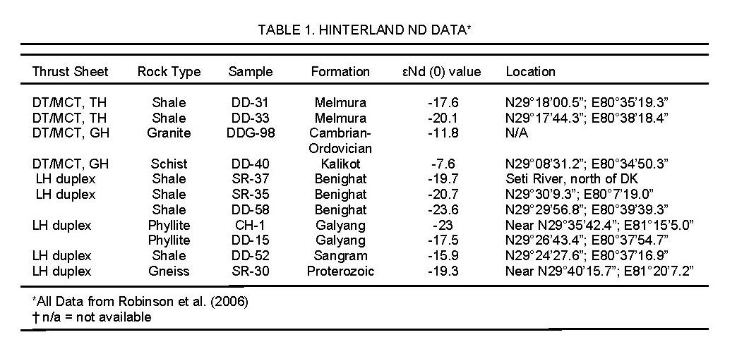
The topographic front of the SH foothills is the Main Frontal thrust (MFT); however, the thrust is not exposed at the surface (Figs. 2 and 3a). North of the MFT are the SH rocks. The Siwalik Group was shed from the rising Himalaya at Khutia Khola by ca. 13.3 Ma (Ojha et al., 2000); however, the base is covered by alluvium so the unit may be as old as 15.1 Ma, the youngest documented age of the LH Dumri Formation rock (DeCelles et al., 1998a). The entire Siwalik Group is unmetamorphosed and coarsens upward. The lower unit is composed of relatively thin sandstone channel deposits and reddish overbank siltstone and calcic paleosols (Fig. 4a). At Khutia Khola, the lower Siwalik unit is at least 862 m thick, and consists of interbedded sandstones and mudrocks (DeCelles et al., 1998a). Detrital zircon U-Pb ages show age populations of ca. 500-800 Ma; 1000-2100 Ma and 2400-3200 Ma, with an upsection increase in grains from the 450-500 Ma and ~1000-1500 Ma populations (DeCelles et al., 2004). The first appearance of high-grade metasedimentary lithic grains, kyanite, and sillimanite, derived from rocks of Greater Himalayan (GH) affinity occurs in the upper part of the lower Siwalik unit (DeCelles et al., 1998b) dated at ca. 11 Ma (Ojha et al., 2000). The average εNd(T) value is -16 (Huyghe et al., 2001; Robinson et al., 2001).
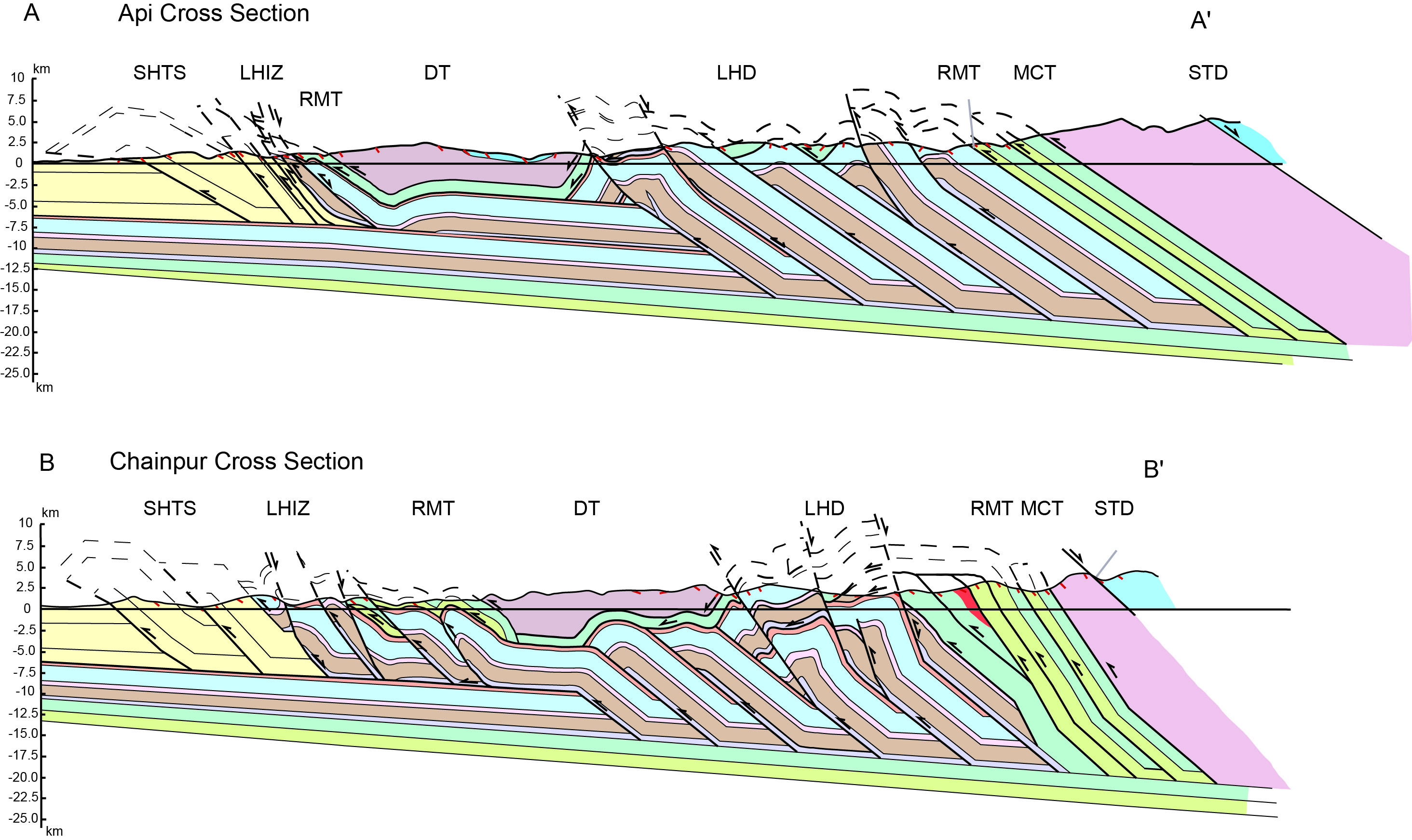
Figure 3. Geological Cross sections

Geological cross-sections (a) Api and (b) Chainpur modified from Robinson et al. (2006)
The lithologic change from lower to middle Siwalik units is at 10.8 Ma at Khutia Khola (Ojha et al., 2000). The middle Siwalik unit at Khutia Khola is 2468 m thick and is characterized by stacked multistory channel sandstones separated by thin, gray overbank mudstone beds and both calcic and histic paleosols (DeCelles et al., 1998a) (Figs. 4b and 4c). Clasts of limestone and dolostone derived from the LH Lakharparta Group first appear at the base of the middle Siwalik unit at ~10.8 Ma and their abundance increases upsection (DeCelles et al., 1998a) indicating derivation from the LH duplex. An upward excursion in the 87Sr/86Sr ratio of pedogenic carbonate nodules in mudstones of the Siwalik Group at ~9 Ma is another indication of LH carbonate erosion (Quade et al., 1997). In addition, εNd(T) values become more negative from -16 to -18 between 10 and 9 Ma and remain at these values throughout deposition of the middle Siwalik unit (Robinson et al., 2001). Hinterland εNd(T) values are presented in Table 1. Szulc et al. (2006) found similar up-section trends in εNd(T) values and 87Sr/86Sr ratios of whole rock mudstone and conglomerate matrix samples in three sections of the Siwalik Group in western and far-western Nepal. Combined with 40Ar/39Ar ages from detrital white micas, these data were interpreted by Szulc et al. (2006) as evidence for the onset of significant erosion of Lesser Himalayan rocks in the Lesser Himalayan duplex by about 12-10 Ma.
The middle to upper Siwalik unit transition at Khutia Khola has not been dated by paleomagnetic stratigraphy (Ojha et al., 2000). At Surai Khola, this lithological transition was dated at ~3.2 Ma (Ojha et al., 2009). The upper Siwalik unit at Khutia Khola is at least 1000 m thick, and is dominated by fluvial conglomerate and sandstone, with histic paleosols (DeCelles et al., 1998a) (Fig. 4d). Detrital εNd(T) and 87Sr/86Sr ratios continue the upsection trends documented in the middle Siwalik unit (Szulc et al., 2006), and an increase in conglomerate clasts derived from LH rocks (quartzite and carbonate clasts) indicates emergence of local Lesser Himalayan sources in the hanging wall of the Main Boundary thrust (MBT; DeCelles et al., 1998b).
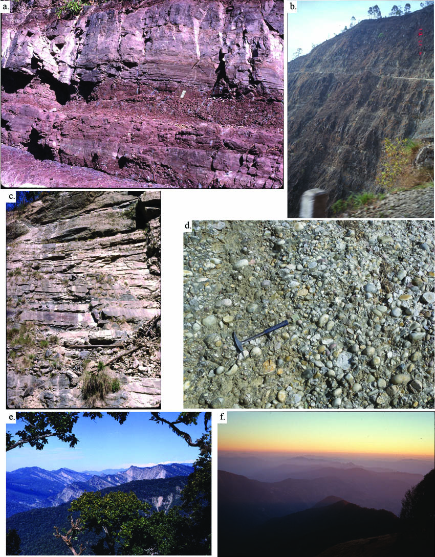
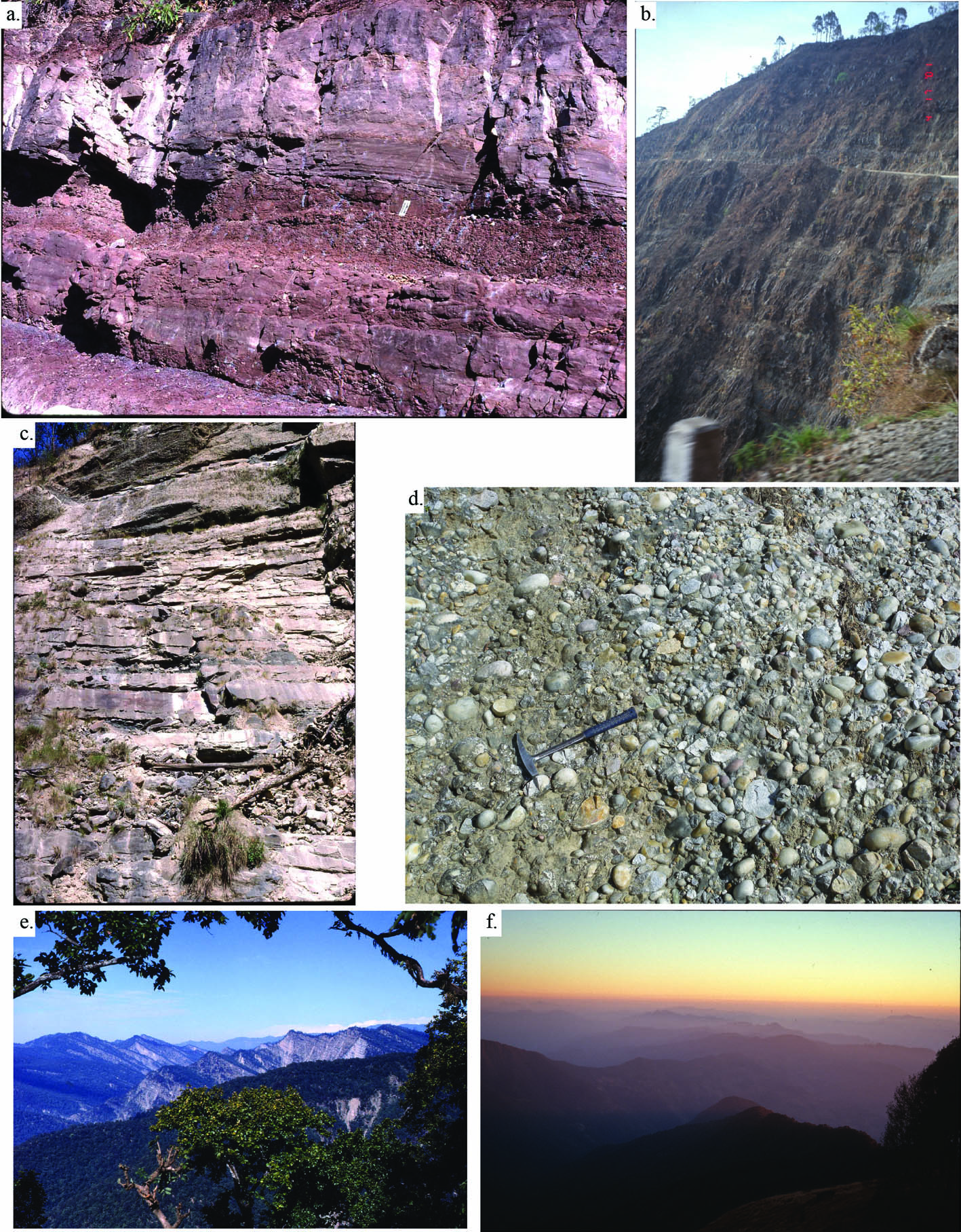
Figure 4. Siwalik Group
(a) Lower Siwalik Group in Khutia Khola. Photo shows a crevasse splay (below), channel (above), and red calcic paleosol deposit. Long edge of scale is 20 cm long. (b) Middle Siwalik Group showing stacked sandstone deposits. Road for scale. (c) Middle Siwalik Group in Khutia Khola. Photo shows stacked multistory sandstone channel deposits. Height of outcrop is approximately 7 m. (d) Upper Siwalik Group along the Dadeldhura road, showing a well-organized conglomerate near the village of Kanidanda. 0.3 m rock hammer for scale. (e) A rare clear view looking to the west of the Subhimalayan thrust system from the Dadeldura road. High cliffs in the back ground are mostly in the middle Siwalik Group. (f) The Subhimalayan thrust system from the MBT looking south at sunset.
The Siwalik Group strata are imbricated on top of one another in 3 thrust sheets in the SH thrust system (Figs. 4e and 4f). The southernmost panel of lower, middle, and upper Siwalik Group rocks is carried by the MFT. The next thrust sheet to the north is the Main Dun thrust and carries only the lower and middle Siwalik Group rocks (Mugnier et al., 1999). North of that thrust sheet is third unnamed thrust sheet carrying lower and middle Siwalik Group rocks.
Lesser Himalayan Rocks South of the Dadeldhura Klippe
The MBT is the last thrust in the LH duplex system and separates LH rocks to the north from SH rocks to the south. The MBT (N29º05’13.6”; E80º34’09.4”; 1335±24 m) is not apparent along the road because it is buried by Quaternary gravel composed of quartzite clasts. Cross section A-A’ (Fig. 3a) necessitates that the MBT has been reactivated as a normal fault, and may explain the modern conglomerate deposit.
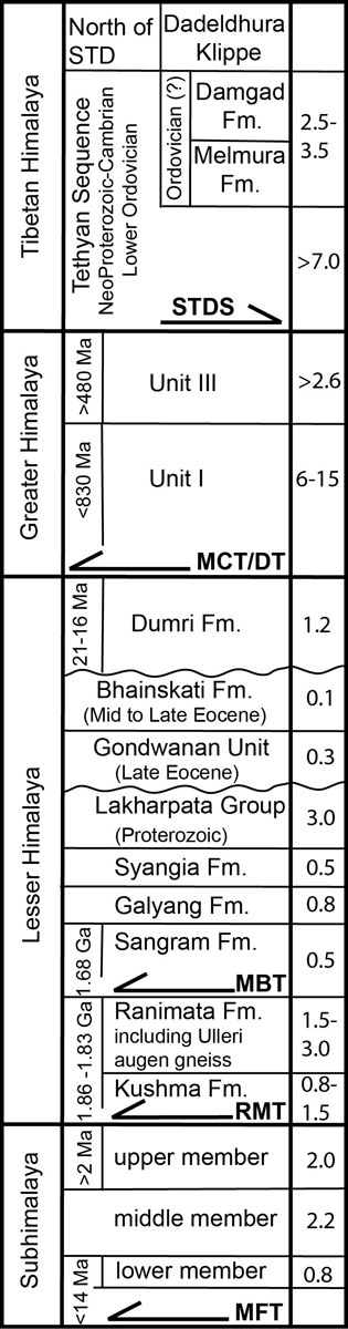
The Lesser Himalaya throughout Nepal is composed of three stratigraphic successions that are separated by major regional unconformities: the Lesser Himalayan sequence; the Gondwana sequence; and the Eocene-lower Miocene foreland basin sequence (Fig. 5). The LH sequence has a thickness of ~10-13 km in central Nepal (Sakai, 1985; Upreti, 1996, 1999; Pearson, 2002). In western Nepal, the stratigraphic thickness may be similar, but structural complexity hampers an accurate estimate. In far western Nepal, Robinson et al. (2006) use an estimated thickness of 8.7-10.9 km of the LH rocks to balance the cross sections as estimated from map thicknesses and the thicknesses determined in the cross section.
Spend the night camping at Budar (Camp 2 on Fig. 2).
Figure 5. Lesser Himalayan stratigraphy
Lesser Himalayan stratigraphy modified from Robinson et al. (2006). Numbers in right hand column indicate approximate thicknesses of each unit in kilometers