Field Trip
The trip takes us from the core of the Kathmandu synform northwestwards to the Main Central thrust / Mahabharat thrust, largely following National Highway 4 (Prithivi Highway). The principal focus is deformation across the contact between Sheopuri gneiss and schists of the Bhimphedi Group exposed in the Galchi area. Previous work here states that the contact is (1) indistinct, separating lateral equivalents (e.g., Stöcklin and Bhattarai, 1982); (2) the top-to-the-south Main Central thrust (e.g., Rai et al., 1998); (3) contained within the top-to-the-south Main Central thrust shear zone, with the schists overlying the gneisses (Johnson et al., 2001); or (4) the top-to-the-north South Tibet detachment (Webb et al., 2011). Observations along this transect allow us to test predictions of Lesser Himalayan Crystalline Nappe models for this contact; given the authorship it may be no surprise that the proposed stops display evidence in support of the fourth model. In turn, this structural framework is consistent with the tectonic wedging model discussed above (see section 3.1).
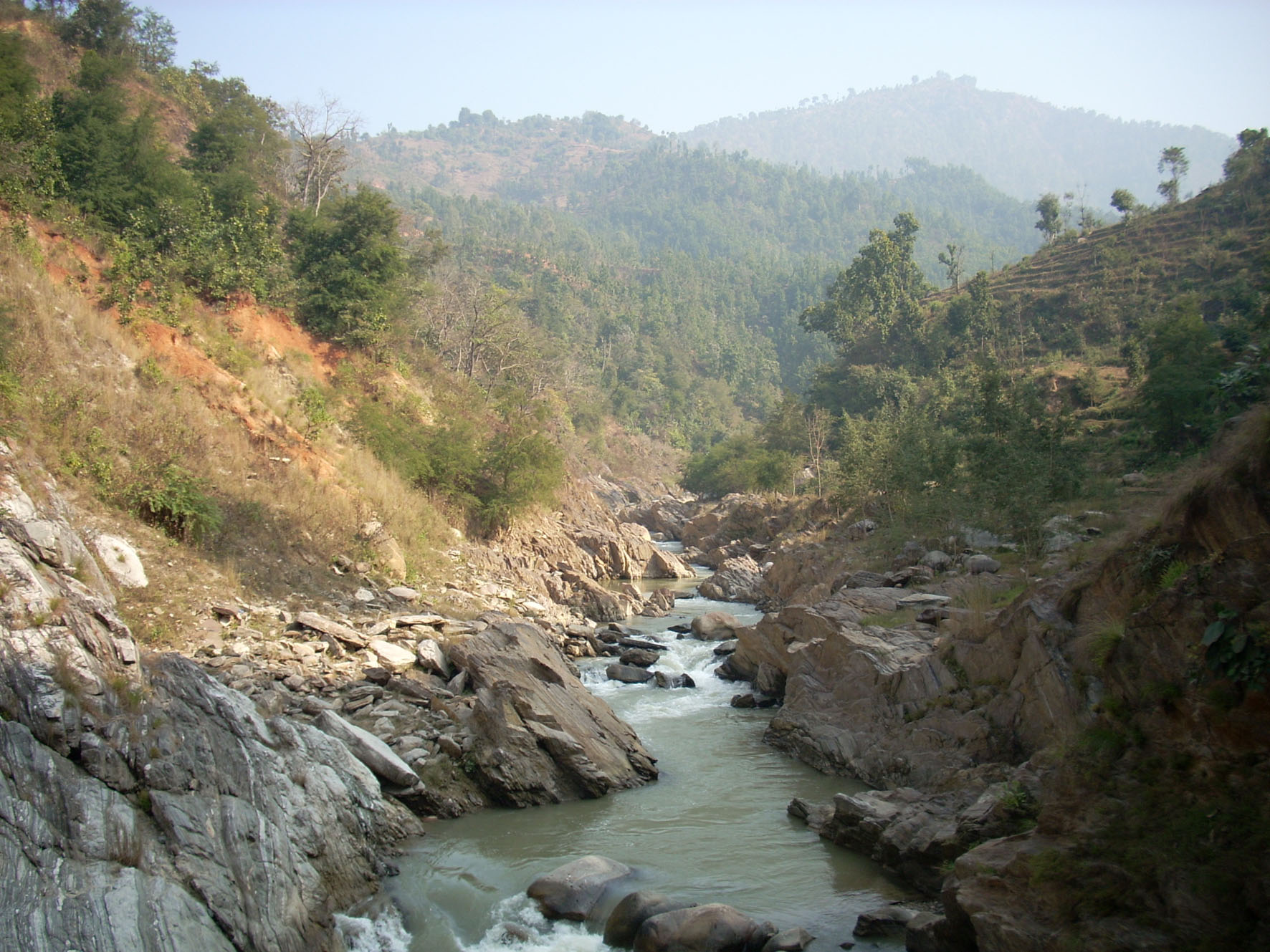
It is worth noting at this point that outcrop quality is generally poor throughout the Kathmandu Nappe region, so the first few stops may be quite discouraging. The rocks will typically be exposed in road-side outcrops of middling to terrible quality, with variable degrees of in-place alteration. But do not lose heart: the erosive power of the Mahesh Khola (Mahesh River) ensures that Stops 5 and 6 alone are worth the price of admission, with spectacular continuous outcrop along the stream bank.
STOPS 1 & 2: Phulchauki Group immediately west of Kathmandu; chlorite-bearing Bhimphedi Group.
Tracking the initial increase in metamorphic grade with structural depth: chlorite zone.
Make one or two quick stops early in the day to establish the lack of high grade rocks in the core of the Kathmandu synform. Outcrops are poor and traffic can be too difficult for road-side observation (you’ll still be in the Kathmandu city area), so play this portion of the trip by ear. The road quickly passes through the Chandragiri Limestone and Sopyang Slates of the Phulchauki Group and the Tistung Formation of the Bhimphedi Group before largely following the Mahesh Khola (Mahesh River) through Kulikhani quartzites, phyllites, and schists (Bhimphedi Group) (Figure 2).
STOP 3: Biotite-bearing Bhimphedi Group (Kulikhani Formation). Location: N27°45.982’, E85°02.527’.
Tracking the gradual increase in metamorphic grade with structural depth: biotite zone.
This road-side stop is in the Kulikhani member Formation of the Bhimphedi Group as mapped by Stöcklin and Bhattarai (1982) and the biotite zone as mapped by Johnson et al. (2001) (Figures 2, 3). Main lithologies are biotite schists and quartzites, with foliation dipping steeply to moderately to the south-southeast. The foliation features a crenulation lineation plunging shallowly to the east-southeast. Thin (~50 m) sills of augen granite gneiss also outcrop near this stop; one such sill ~1.5 km down section (near the garnet-in isograd) yielded a ~470 Ma U-Pb zircon crystallization age (Johnson et al., 2001).
STOP 4: Garnet-bearing Bhimphedi Group (Kulikhani Formation). Location: N27°47.832’, E85°00.731’.
Tracking the gradual increase in metamorphic grade with structural depth: garnet zone
The structural position of this road-side stop is somewhat debated: it is in the mixed zone of Sheopuri gneiss and the Kulikhani member Formation (Bhimphedi Group) as mapped by Stöcklin and Bhattarai (1982), and the garnet zone of the Bhimphedi Group as mapped by Johnson et al. (2001) and Webb et al. (2011) (Figures 2, 3). The main lithology is garnet – biotite schist, with garnets up to 3 mm in diameter, with foliation dipping steeply to moderately to the south-southeast. The schists are crenulated, with the crenulation fold axis plunging moderately to the southwest. Outcrop quality is generally poor.
STOP 5: Galchi shear zone on the southwestern bank of the Mahesh Khola. Location: N27°47.901’, E85°00.213’.
Shear zone developed across quartzites and gneisses.
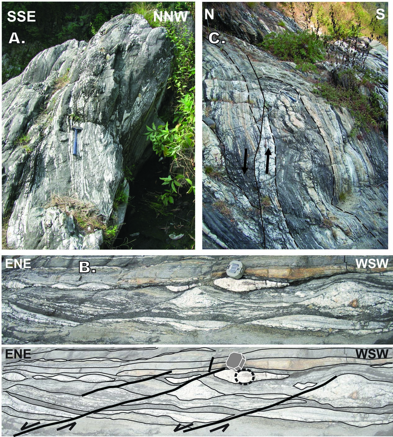
This stop is a highlight of the trip: here we may explore deformation along the contact between Sheopuri gneiss and schists of the Bhimphedi Group. Park vehicles at the southeastern limits of the village Galchi, walk down a steep path to the southwestern bank of the Mahesh Khola, walk ~400 m upstream, and then work your way back this route making observations (Figure 7). The working area is roughly coincident with the kyanite-in isograd as mapped by Johnson et al. (2001) (Figure 4), and observations outlined herein largely follow Webb et al. (2011). Note: the path down to the Mahesh Khola is not long, but it is *very* steep and so must only be attempted with great care in good weather.
Figure 7. View looking east-southeast (upstream) along Mahesh Khola near Galchi
Stop 5 extends along the southwest (right) bank of the stream here; the south end of Stop 6 is at the left, foreground
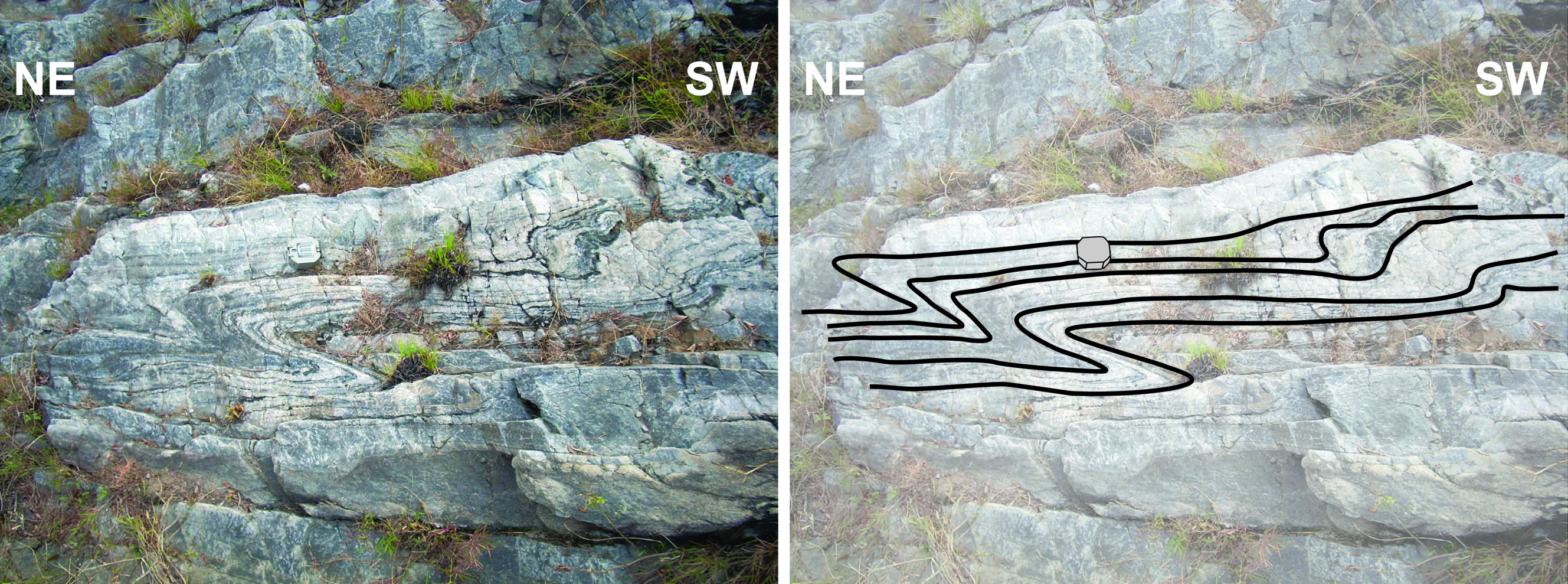
Foliation here generally dips steeply / sub-vertically to the south-southeast. At the farthest southeast, upstream point of this stop, quartzites with meter-scale tight asymmetric cylindrical folds of parallel bedding and micaceous foliation occur (Figure 8). The fold asymmetry suggests an oblique (south block up, left-lateral) shear sense in present orientation.
Figure 8. Top-to-the-northeast asymmetric folds in quartzite
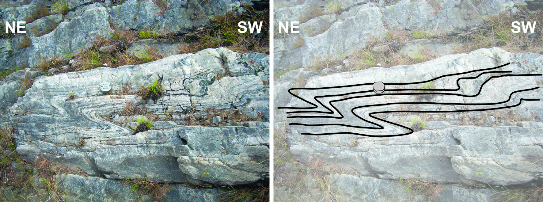
Top-to-the-northeast asymmetric folds in quartzite immediately above the gneiss of the Galchi shear zone, at Stop 5 (from Webb et al., 2011). Brunton compass for scale, view to southeast looking down ~40°
To the northwest, the quartzites are underlain by a ~200 m thick section of psammitic and pelitic gneiss with minor leucogranitic lenses. These rocks represent the uppermost Sheopuri gneiss. They are strongly deformed, forming a shear zone that Webb et al. (2011) termed the Galchi shear zone after the local village. The remainder of this stop (back towards the parking spot) extends across the upper (southeastern) half of the Galchi shear zone. The upper half of the shear zone features sheath folds, mineral stretching lineations defined by biotite, feldspar, and tourmaline which are parallel to the long axes of the sheath folds (plunging moderately to the west-southwest), S-C fabric, S-C’ fabric, sigma-type porphyroclasts, and meter-scale asymmetric boudinage. Leucogranitic lenses are foliated and deformed by asymmetric boudinage, indicating that they are pre- and/or syn-kinematic. Excepting decimeter-scale antithetic thrust faults, all structures have a consistent sense of shear: the Galchi shear zone appears to be an east-northeast striking steep oblique fault with left-lateral, south-block-up motion. Interpretation of the kinematics is discussed in the context of Stop 6, see below.
STOP 6: From the Galchi shear zone to the Main Central thrust / Mahabharat thrust on the northeastern bank of the Mahesh Khola. Location: N27°47.916’, E85°00.158’.
Shear zone developed across gneisses, succeeded to the north, i.e., down structural section, by (first) relatively undeformed metasedimentary rocks and (second) a shear zone with opposite shear sense.
Stop 6 continues exploration of the Galchi shear zone, starting where Stop 5 left off, but on the northeast bank of the river (Figure 9). To get to this point, get back in the vehicles and travel a short distance along the road heading north from Galchi along the Trishuli River. At the bridge that crosses the Mahesh Khola, disembark and walk a little farther east (<100 m) along the road, then head up a trail to the right. The trail will wind steeply up a hill, then steeply down to the Mahesh Khola. Walk upstream along the Mahesh Khola until you are opposite from the end-point of Stop 6. At this point, start making observations and work back to the base of the bridge over the Mahesh Khola.
Figure 9. View looking north-northwest along the Mahesh Khola near Galchi
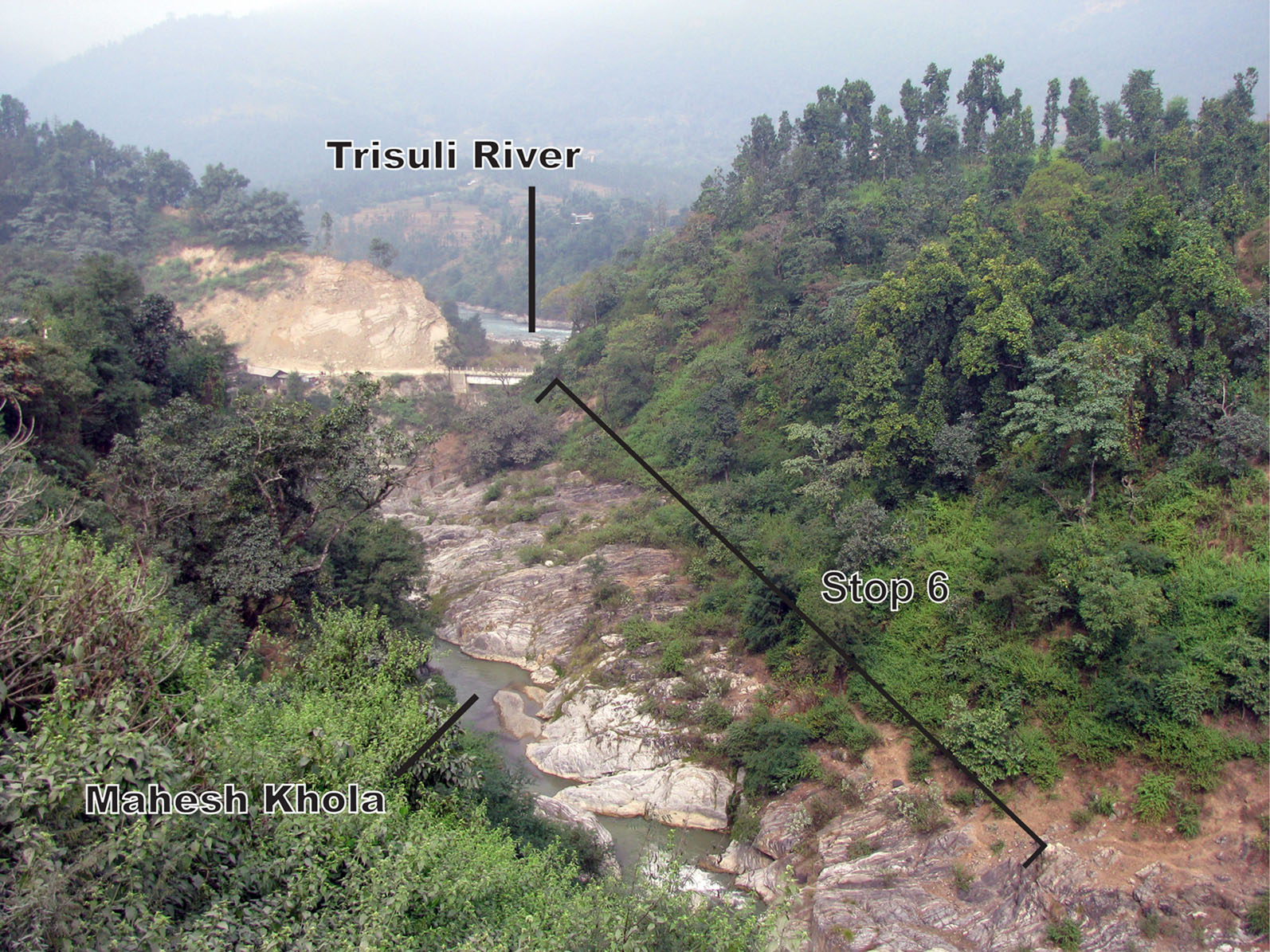
View looking north-northwest (downstream) along the Mahesh Khola near Galchi, with the Trishuli River in the background (modified from Webb et al., 2011). Stop 6 extends along the northeast (right) bank of the stream here
At the starting point of the Stop 6 work, again observe psammitic and pelitic gneiss with minor leucogranitic lenses, strongly deformed in the Galchi shear zone. Structural fabrics match Stop 5 in type, orientation, and shear sense. Sheath folds dominate the basal ~30 meters of the shear zone (Figure 10A). A pre- and/or syn-kinematic leucogranitic lense here (deformed by asymmetric boudinage) yields a U-Pb zircon crystallization age of ~30-20 Ma, consistent with a latest Oligocene / earliest Miocene oldest age limit for some shearing here (Figure 10B) (Webb et al., 2011). Sparse late structures observed here include decimeter-scale bookshelf normal fault systems and meter-scale thrust faults with associated cylindrical folds, again sharing the left-lateral, south-block-up motion (Figure 10C).
Figure 10. Photographs of deformation in the Galchi shear zone

Photographs of deformation in the Galchi shear zone at Stop 6 (modified from Webb et al., 2011). A. Sheath fold, looking down the long axis. View looks to the west-southwest and down ~10°, hammer for scale. B. Composite photograph and line diagram of top-northeast asymmetric boudinage, including shear bands that cross-cut gneissic foliation and leucogranitic lenses. Dashed oval marks a dated leucogranite sample (U-Pb zircon crystallization age of ~30-20 Ma). View looking east-southeast and down ~50°, brunton compass for scale. C. Meter-scale thrust fault, view looking east and down ~10°, hammer for scale (circled)
To the north (downsection), the Galchi shear zone is underlain by a ~300 m thick section of quartz-rich garnet mica schists. These rocks are differentiated from the Galchi shear zone by the amount of felsic / mafic segregation (i.e., they’re schists, not gneiss) and because the dominant structural fabric is mica foliation, with S-C fabric occurring in only a ~10 m thick layer. This layer occurs in the middle of the section and has opposite shear sense vs. the Galchi shear zone. That is, shear sense in the ~10 m thick layer is oblique with right-lateral, south-block-down motion.
The foliation-dominated schists persist to the base of the Galchi bridge, which cuts off the transect. Back at the road (just ~10 meters farther downsection to the north), garnet-mica schists display S-C and S-C’ fabric with right-lateral, south-block-down sense of shear. These schists represent the top of a ~1 km thick shear zone dominated by similar fabrics, i.e., the Main Central thrust / Mahabharat thrust.
Timing of shearing along the Main Central thrust / Mahabharat thrust and the Galchi shear zone. Regional timing constraints suggest that deformation along the Galchi shear zone and Main Central thrust / Mahabharat thrust occurred simultaneously or in close succession. The date of the deformed Galchi shear zone leucogranite requires that at least some shearing here occurred at or after the latest Oligocene / earliest Miocene, which is consistent with regional oldest limits for shearing along the Main Central thrust (e.g., Kohn et al., 2004; see summary by Godin et al., 2006). Ductile shear in both faults must cease by the middle Miocene, since a wealth of 40Ar/39Ar muscovite ages across the Lesser Himalayan Sequence and Kathmandu synform in this region yield middle Miocene dates (Arita et al., 1997; Herman et al., 2010).
Interpretation of shear sense along the Main Central thrust / Mahabharat thrust and the Galchi shear zone. The Main Central thrust / Mahabharat thrust appears as a sub-vertical, east-northeast striking shear zone with right-lateral, south-block-down sense of shear in the vicinity of Galchi village. The Galchi shear zone has the same orientation, with opposing shear sense. However, the regional map pattern (Figures 1, 2) demonstrates that the faults are folded within the Kathmandu synform here, so the synform deformation must be removed if we are to consider the direction of shearing during motion along the faults.
The “unfolding” of the Kathmandu synform requires assumptions because the Kathmandu synform is non-cylindrical. Webb et al. (2011) performed this exercise by assuming (1) that the active orientation and shear sense along the Main Central thrust / Mahabharat thrust were sub-horizontal / shallowly north-northeast dipping and top-to-the-south-southwest, respectively, and (2) the same rotations required to restore the Main Central thrust / Mahabharat thrust to this orientation could reasonably be applied to the Galchi shear zone to constrain its orientation and shear sense during fault motion. The details of their approach are described in Inset 1. The results are consistent with top-to-the-north-northeast motion along the sub-horizontal Galchi shear zone.

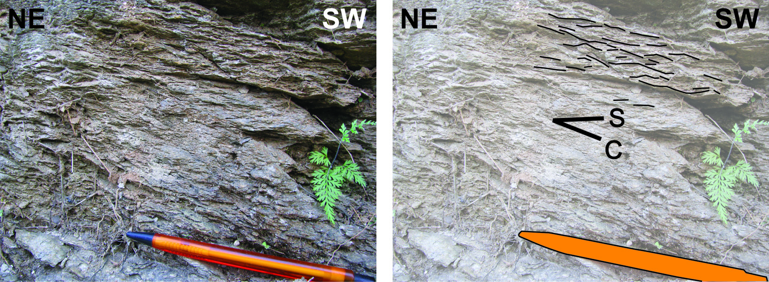
STOP 7: The Main Central thrust / Mahabharat thrust along the Trishuli River. Location: N27°48.542’, E85°00.892’.
Top-S S-C fabric developed across garnet schist.
This road-side stop is in the Main Central thrust / Mahabharat thrust zone along the Trishuli River (Johnson et al., 2001; Pearson and DeCelles, 2005; Webb et al., 2011) (Figures 2, 3). The main lithology is garnet – mica schist, with garnets up to 8 mm in diameter. The schists display S-C fabric with main (C) foliation dipping steeply to the south-southeast (Figure 11). Shear sense is right-lateral, south-block-down in present coordinates.
Figure 11. Top-to-the-southwest S-C fabric within the Main Central thrust

Top-to-the-southwest S-C fabric within the Main Central thrust / Mahabharat thrust shear zone at Stop 7 (from Webb et al., 2011). View looking down ~40° to the southeast, pencil for scale.
Time-permitting, there is a very good opportunity to see these rocks well exposed just a little off the main road. This stop is near a bridge crossing a tributary of the Trishuli. A ~40 meter walk from this bridge along the south bank of the tributary, there is fresh exposure in a small waterfall to the right.
STOP 8: Lesser Himalayan quartzites along the Trishuli River. Location: N27°50.475’, E85°01.397’.
Confirmation of the basal limit of the Kathmandu Nappe.
This stop extends north of the Main Central thrust / Mahabharat thrust zone to confirm the thickness of the shear zone and the presence of Lesser Himalayan Sequence rocks down-section. This road-side stop is in the Main Central thrust / Mahabharat thrust footwall along the Trishuli River (Johnson et al., 2001; Pearson and DeCelles, 2005; Webb et al., 2011) (Figures 2, 3). Here, fine-grained, grey, partially recrystallized quartzite layers dip steeply to the south-southeast.
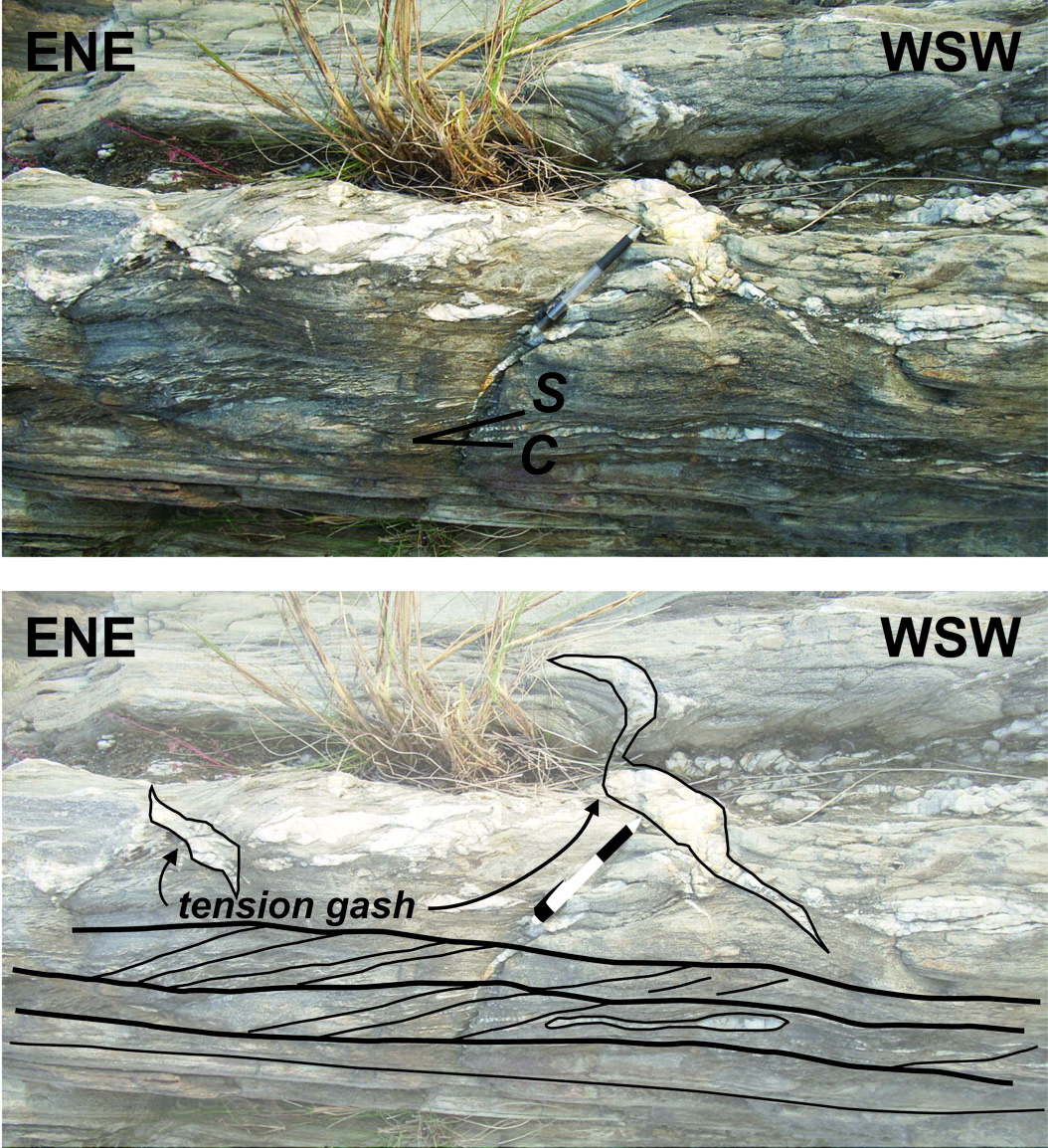
If Time Permits STOP 9: The Main Central thrust / Mahabharat thrust along the Malekhu Khola. Location: N27°47.861’, E84°50.135’.
Confirmation of the basal limit of the Kathmandu Nappe.
Given sufficient time, drive to Malekhu and walk ~1 km south along the Malekhu Khola (Figure 2). This walk leads upsection through Lesser Himalayan Sequence rocks to the Main Central thrust / Mahabharat thrust. Malekhu Khola geology is similar to that of the Mahesh Khola, with rocks and structures again dipping steeply to the south-southeast and structural elevation increasing to the south. However, the Galchi shear zone gneiss and fabrics and the underlying foliated quartz-rich garnet mica schists (above the Main Central thrust / Mahabharat thrust) do not appear here.
The Main Central thrust here is a ~600 m thick shear zone dominated by S-C fabric; sense of motion is oblique (right-lateral with the south-block moving down). Quartzite and phyllonite of the Lesser Himalayan Sequence portion of the Main Central thrust / Mahabharat thrust display asymmetric boudinage and tension gashes (Figure 12). The southern portion of the Main Central thrust zone is dominated by garnet mica schist with S-C fabric. A <100 m thick layer of marble (Bhainsedobhan Marble of Bhimphedi Group, Stöcklin and Bhattarai, 1982) occurs immediately above Main Central thrust zone. Farther south, micaceous quartzites, garnet-biotite schist, biotite schist of Kalitar Formation and Chisapani Quartzite (Bhimphedi Group, Stöcklin and Bhattarai, 1982) dominate; a ~200 m thick foliated granitic sill occurs ~1.5 km south of the marble. Metamorphic grade is inverted across the Main Central thrust but right-way-up in its hanging wall. No gneiss or leucogranitic rocks are observed, and the garnet isograd occurs ~2 km above the shear zone. The lithologies, right-way-up metamorphic field gradient, and structural fabrics observed across the Main Central thrust / Mahabharat thrust hanging wall are consistent with the Bhimphedi Group.
Figure 12. Top-to-the-southwest S-C fabric and tension gashes within the Main Central thrust

Top-to-the-southwest S-C fabric and tension gashes within the Main Central thrust / Mahabharat thrust shear zone at Stop 9 (from Webb et al., 2011). View looking down ~85° to the south-southeast, pencil for scale