The Geology
Geologic data of this remote area between Kun-Lun and Karakorum (Fig. 2) are very scarce. A short account is reported and summarized from Gaetani et al. (1991), Rolfo & Groppo (2007), Groppo & Rolfo (2008).
From the Yarkand valley to the north, to the Shaksgam valley through the Surukwat valley and the Aghil Pass to the south, different geologic units are separated by syn- to late-metamorphic thrusts and post-metamorphic faults of similar attitude and they are: Bazar Dara Slates, Surukwat Complex, Aghil Dara Granodiorite, Shaksgam Sedimentary Belt (Fig. 3). To the SW of the Karakorum Fault highly deformed and feebly metamorphosed slices of the Wakhan Slates and the North Karakorum Sedimentary Belt are preserved, before to reach the K2 metamorphics.
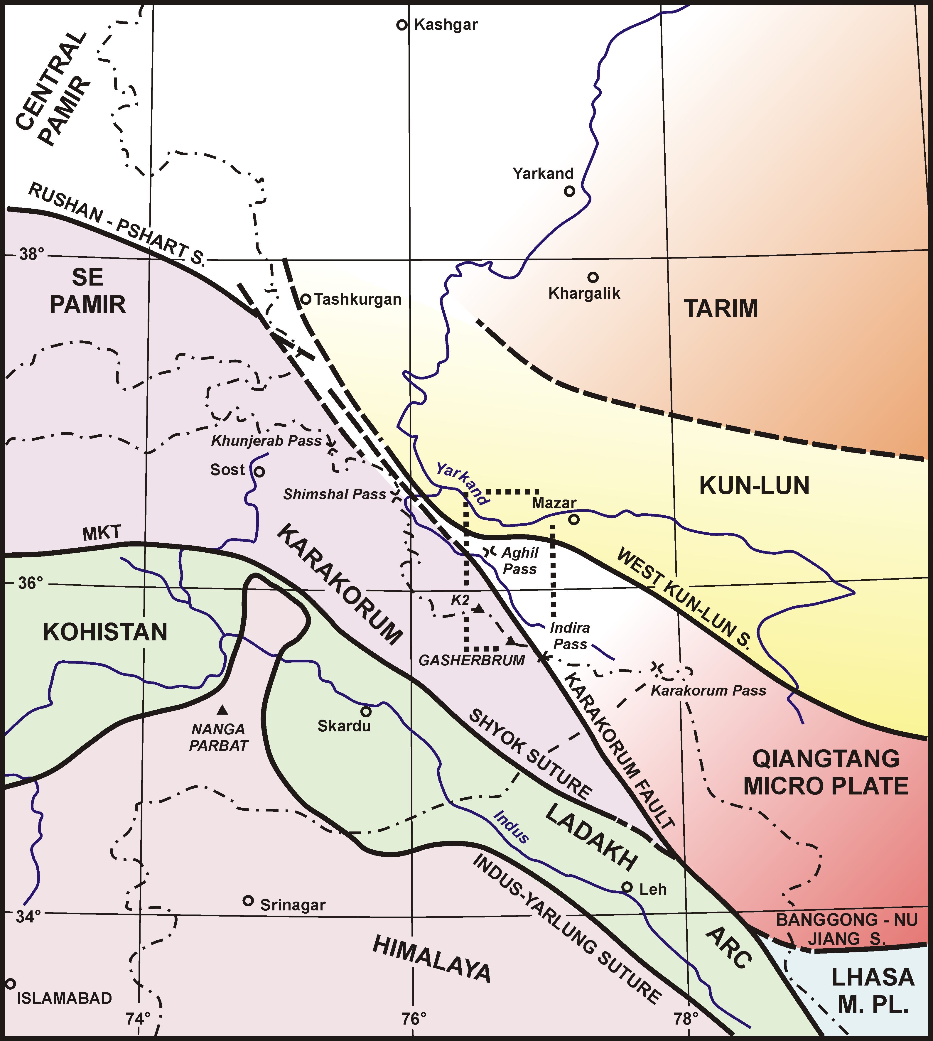
Figure 2. Tectonic framework of NW Himalaya
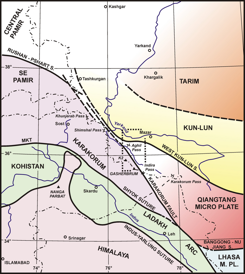
Tectonic framework of NW Himalaya from Islamabad to Kashgar, modified after Gaetani et al. (1991). Dotted rectangle underlines the studied area.
Figure 3. Geological map from the Shaksgam to the Yarkand valley
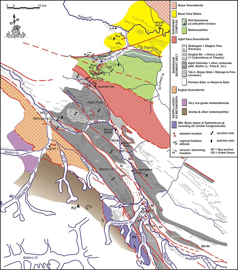
Geological map from the Shaksgam to the Yarkand valley, redrawn from Gaetani et al. (1991) and modified after Rolfo & Groppo (2007). Locations of samples described in the text are reported.
Field, petrographic and petrologic data (Rolfo & Groppo, 2007; Groppo & Rolfo, 2008) suggest that the Bazar Dara Slates may be the sedimentary cover of Kun-Lun, while the Shaksgam Sedimentary Belt is possibly the cover sequence of a metamorphic basement (the Surukwat Complex) characterised by an inverted metamorphism and intruded by the Aghil Dara Granodiorite. According to most of the large scale geological reconstructions (Gaetani et al., 1990, 1993; Zanchi, 1993), the Aghil Range is the possible north-western extension of the Qiangtang microplate separating Kun-Lun from Karakorum and shows strong sedimentary affinities with SE Pamir (Gaetani, 1997). The correlation of the Aghil Range to the Qiangtang terrane of the Tibetan Plateau has been also recently documented by Robinson (2009a, b), based on observations from satellite images.
Bazar Dara Slates
The Bazar Dara Slates are best exposed along the Yarkand valley as an unmetamorphosed to metasedimentary sequence of sandstones, siltstones and slates, steeply dipping towards SSE and locally intruded by undeformed granitic bodies and dykes. All lithologies are devoid of fossils and consequently their protolith age is questionable. The age of the Mazar granite intruding the sequence (Fig. 3) is also unknown: it is claimed to be Late Paleozoic in the Metamorphic Map of China by comparison with other Late Paleozoic granitic intrusions on the Kun Lun Range (Cheng et al., 1986); however, preliminary K-Ar cooling data suggest a significantly younger age.
The metamorphic lithologies are locally rich in deformed quartz + carbonate veins systematically parallel to the regional foliation, suggesting a quite intense stress regime. As concerning metamorphic conditions, the local occurrence of biotite and white mica assemblages overgrowing a previous, lower grade foliation suggest a complex metamorphic history reaching a upper greenschist facies metamorphic peak (Rolfo & Groppo, 2007).
Surukwat Complex
Located south of a major subvertical fault striking WSW-ENE, the Surukwat Complex is a composite sequence of thrust sheets and strongly squeezed eradicated anticlines trending WNW-ESE and steeply dipping SSW (Fig. 4a, b) in which, safe for the occurrence of few non-metamorphic slivers, a general increase of metamorphic grade is evident southward from lower to higher structural levels (Rolfo & Groppo, 2007) and is compatible with compositional changes recorded by minerals (Fig. 5). Protoliths vary from sedimentary rocks (carbonate rocks, greywacke, conglomerate, marl and pelite) to igneous rocks (granodiorite and diorite).
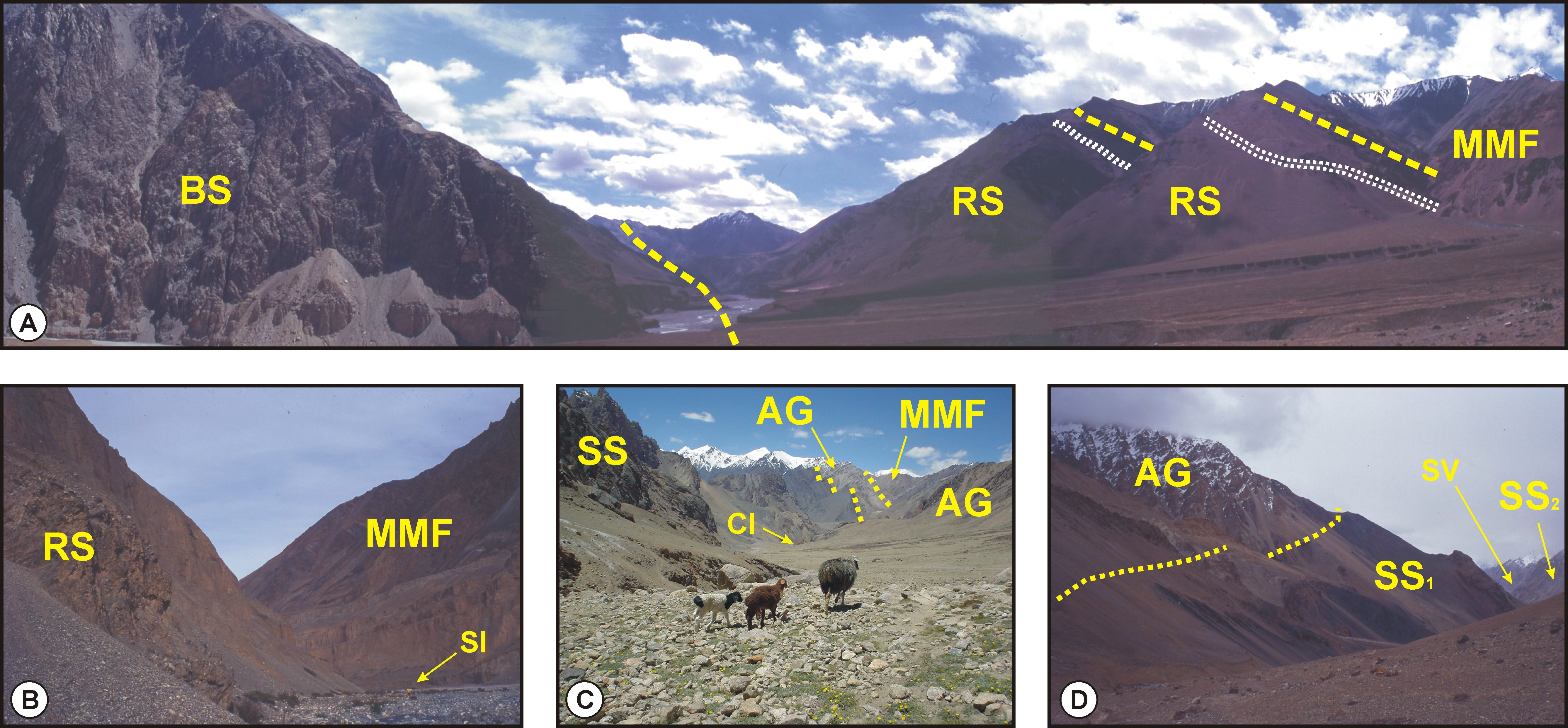
Figure 4. Geological map from the Shaksgam to the Yarkand valley
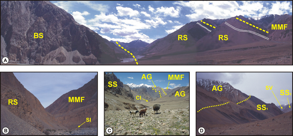
A) Geologic cross section at the junction between Aghil Dara river and Zug Shaksgam (Surukwat) river, lower Aghil Dara valley. View looking eastwards. BS: Bazar Dara Slates. RS: Red Sandstones (white strip: anhydride horizon). MMF: Metamorphites of the Surukwat Complex. B) Sughet Ilich (SI), middle Aghil Dara valley. View looking eastwards. RS: Red Sandstones. MMF: Metamorphites of the Surukwat Complex. C) Aghil Pass towards Chokor Itik (CI), upper Aghil Dara Valley. View looking NW. SS: Shaksgam Sedimentary Belt. AG: Aghil Dara Granodiorite. MMF: Metamorphites of the Surukwat Complex. D) Aghil Pass towards Shaksgam valley (SV). View looking SE. AG: Aghil Dara Granodiorite. SS: Shaksgam Sedimentary Belt (1: Black Shales; 2: Dolomite and carbonate).
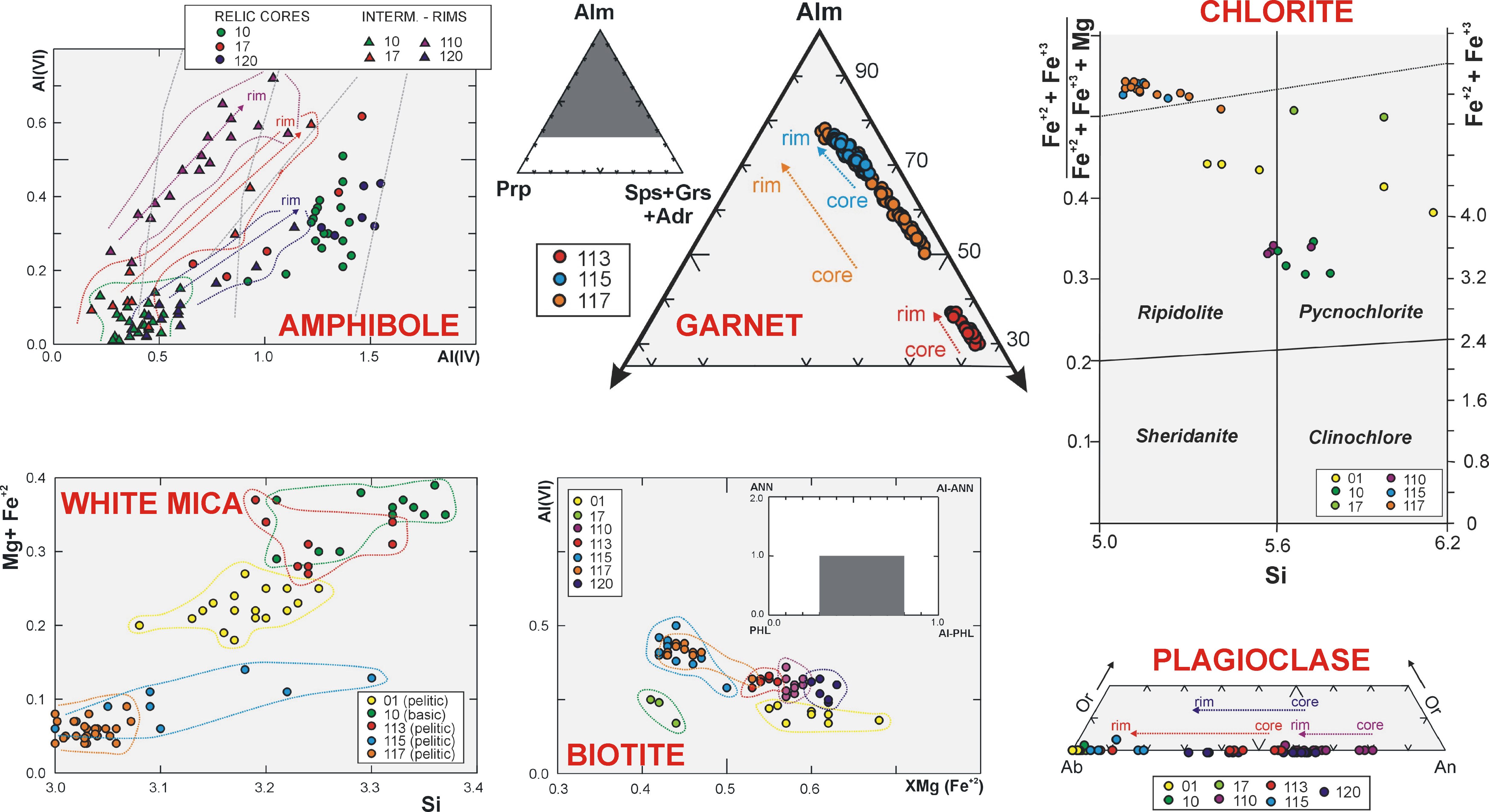
Figure 5. Mineral chemistry of selected samples

Minerals were analyzed with a Cambridge SEM-EDS at Dept. of Earth Sciences, Torino, Italy. Locations of samples are reported in Fig. 3.
At the lowermost structural levels, at the northern contact with the Bazar Dara Slates a series of peculiar slivers of red sandstones and anhydrites (Fig. 4a,b) show a strong affinity with the Qiangtang Microplate (Leeder et al., 1988) and have similar petrographic features to the Jurassic Marpo Sandstone of the Shaksgam valley (Gaetani et al., 1991).
The top of the metamorphic sequence consists of a composite and often intercalated series of laminated quartzite, paragneiss, marble and micaschist. Petrologic investigation of metapelites (Groppo & Rolfo, 2008) constrains the metamorphic peak at moderately high pressure amphibolite facies (550<T<590 oC and 0.77<P<0.91 GPa). More specifically, on the basis of microstructural data, quantitative P-T pseudosection analysis and conventional thermobarometry a steep and narrow counterclockwise P-T path has been inferred for the Surukwat Complex, suggesting very similar burial and exhumation regimes and fully compatible with the evolution of an accretionary system during early stages of underflow. Consequently, the Aghil Range as a whole may be assimilated to the central Qiangtang metamorphic belt as interpreted by Kapp et al. (2000), i.e. an early Mesozoic melange occurring in the footwall of Late Triassic – Early Jurassic domal low-angle detachment faults, representing the Songpan-Ganzi flysch subducted under a single Qiangtang terrane of Gondwanan affinity. Thus, the Surukwat Complex would most probably represent a mid-Phanerozoic accretionary wedge analogous to the central Qiangtang metamorphic belt.
Aghil Dara Granodiorite
The contact between the Surukwat Complex and the weakly deformed Aghil Dara Granodiorite is marked by a cataclastic zone and by the presence of granitic dykes probably related to the intrusion of the granodiorite. A major tectonic contact to the south gives way to the Shaksgam Sedimentary Belt (Fig. 4c,d), non-metamorphic though pervasively folded and faulted towards the Karakorum Fault.
The Aghil Dara Granodiorite is claimed to be Yangshanian (Early Cretaceous) in age in the Metamorphic Map of China (Cheng et al., 1986), similarly to a number of intrusions reported in the southern sector of Karakorum (e.g. Debon et al., 1987; Cerveny et al., 1989; Leloup et al., 2012) likely related to the subduction and collision of the Kohistan-Ladakh arc below the Eurasian margin (Rex et al., 1988). However, this intrusive body has never been dated and it is therefore not possible to unequivocally assume a Karakorum or Qiangtang Microplate source.
Shaksgam Sedimentary Belt
The Shaksgam valley is mostly carved in the Shaksgam Sedimentary Belt, which is non-metamorphic though pervasively folded and faulted towards the Karakorum Fault. The Shaksgam Sedimentary Belt spans from the Lower Permian to Jurassic, as proved by fossils and it is sealed by the Urdok Conglomerate, suggested to be linked to the first deformation phase of the Karakorum Range in the Cretaceous. The sedimentary belt is 5 - 20 km wide and the sedimentary sequence is at least 3 km thick and extends, where proved by fossils, from Permian to Jurassic. The existence of Carboniferous and Cretaceous rocks is doubtful. The sequence is reported in Fig. 6 and here summarized. The sedimentary succession is displaced in a system of open folds, faulted, thrusted and stacked toghether. Large folds possibly represent the initial deformation of the sedimentary sequence. Folding was followed by faults with vertical or subvertical throw, that disrupted the folds and emphasize an antiform structure on both sides of the valley from the Aghil to the Gasherbrum and Staghar glacier snouts (Fig. 7). Fossil corals have been described by Flügel (1990) and Flügel & Gaetani (1991).
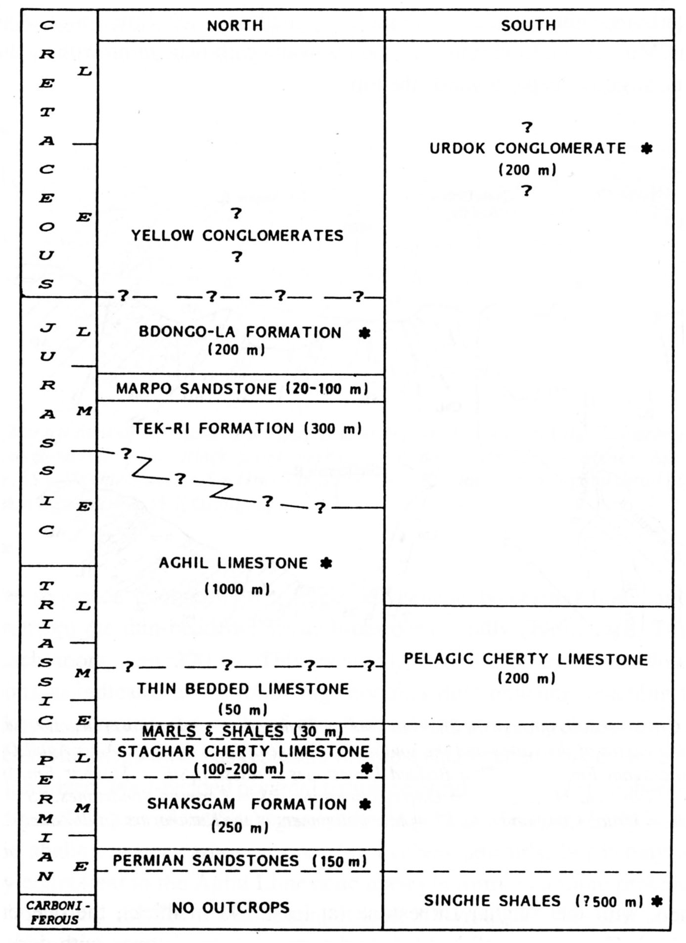
Figure 6. Stratigraphic terminology for the Shaksgam Sedimentary Belt

Stratigraphic terminology for the Shaksgam Sedimentary Belt. Units with asterisk were used or introduced by Desio (1980). The others were introduced by Gaetani et al. (1990).
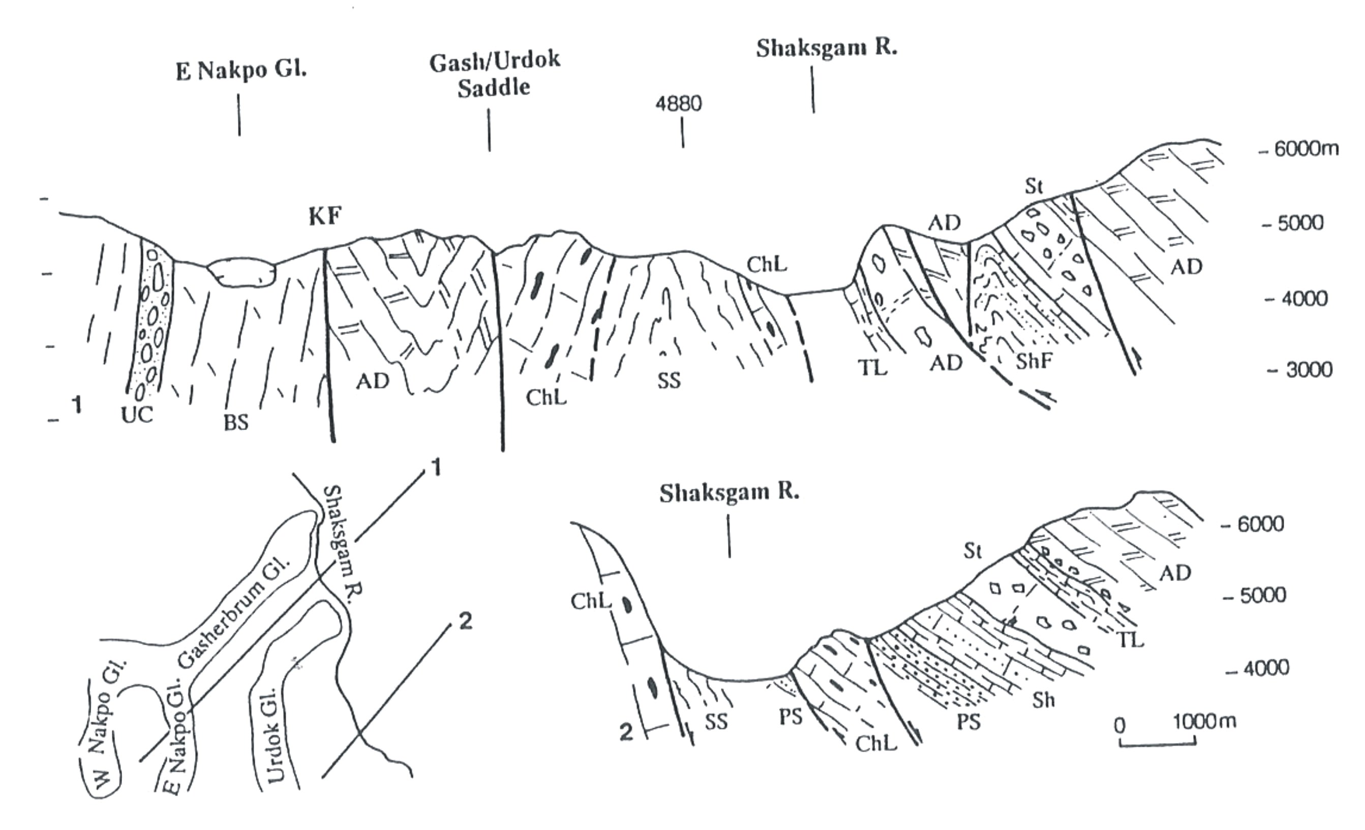
Figure 7. Cross-section through the Shaksgam valley
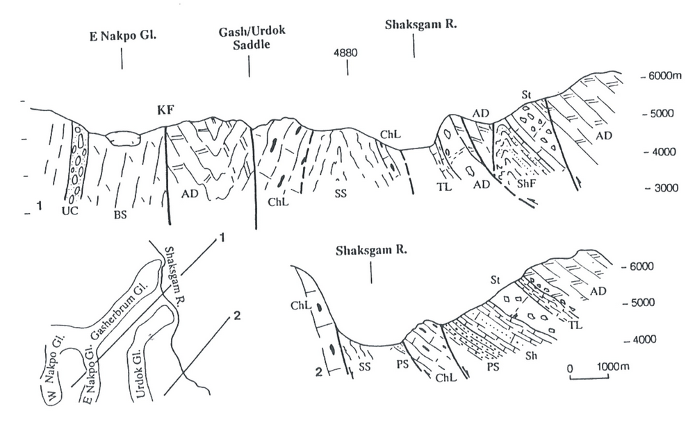
Cross-section through the Shaksgam valley. To note the broad antiform structure, with older rocks at the center of the valley and the southward change of fault dipping. AD = Aghil Dolomite; ShF = Shaksgam Formation; tl = Thin Bedded Limestones (Triassic); StF =Staghar Fm., including resedimented breccia bodies; ChL = Cherty Limestone; PS = Permian Sandstone (2nd member of the Singhè Fm.); SS = 1ts member of the Singhè Fm.; UC Urdok Conglomerate; KF = Main alignment of the Karakorum Fault Zone.
The base of the sedimentary sequence is always thrusted or faulted. It starts with at least 150 m thick grey to dark siltstones, fine sandstones and coarser litharenites in a coarsening-upward sequence of submerged shelf and deltaic sandy bars. At the top, the marine ingression is characterized by sandstones containing fossil fragments.
The following Shaksgam Formation, more than 200 m thick, may be easily subdivided in three members. Top to bottom, they are: C) grey well bedded limestones with marly intercalations; B) quartzarenites, litharenites, hybrid sandstones, with minor carbonate intercalations; A) skeletal shallow water limestones. Age: Artinskian-Roadian. Environment: shallow-water carbonate ramp with cyclic clastic inputs, deeper towards the top.
With the Staghar Limestone (at least 100 m thick), the deepening is emphasized. Grey dark, well bedded wackestone to mudstone with dark cherty nodules form the bulk of the unit. Upwards, the pelagic limestone is increasingly polluted by graded calciruditic to calcarenitic beds, with shallow-water carbonates. At the top, one (or two) huge calciruditic and well-amalgamated calciruditic horizons, up to 50-100 m thick, follow. Age: Capitanian or possibly even early Wuachapingian.
The deep water sedimentation continued through the topmost Permian until the "Thin bedded limestones" (thickness 50 m). These are thin bedded grey-dark mudstone/wackestone, devoid of chert, with thin clay marly interbeds. A few meters above the base, a Spathian age was proved by means of conodonts.
The sequence evolves into a huge polygenetic brecciated body, including boulders from the thin-bedded Triassic limestones, totally dolomitized. Thickness may reach more than 200 m. This event allowed the return to shallow-water conditions, as indicated by the following very thick dolomitic unit, reaching 1000 m in thickness, forming the bulk of the Aghil dolostone. Cyclothemic peritidal sequences with megalodontids represent the most characteristic facies, locally coarsely dolomitized. Well-bedded peritidal sequences grade laterally into massive walls, lining the middle part of the Shaksgam valley. Age: Late Triassic - Early Jurassic.
The shallow-water carbonate complex evolves upwards, but it may also be laterally equivalent to the Aghil Limestone open platform, in a more protected and organic-rich unit, the Tek-ri Formation, at least 300 m thick. This unit consists of bedded grey dark mudstone/wackestones, with rare dark cherts. In the middle and upper part, oncolitic limestone associated with bioclastic packstone are widespread. The benthic Foraminifera suggest a Middle Jurassic age, possibly Bathonian for the top of the Tek-ri Formation.
The carbonate platform development is interrupted by the Marpo Formation, which consists of red sandstones and siltstones, up to l00 m-thick east of the Aghil pass, but usually between 20 and 40 m in the middle part of the valley. Their base is prograding on the Tek-ri Formation. Westwards, the unit starts with alternating grey marls and red siltstones, followed by polymictic conglomerate. It ends with red shaly sandstones. Eastwards in contrast, the sequence is thicker and consists almost exclusively of red fine sandstones and siltstones. From east to west, the interfingering of an alluvial plain with coastal lagoons is recorded.
Another marine ingression with the following Bdongo-la Formation is recorded. At the base there is 10 m bed of dark slightly metamorphosed limestone with corals of Middle Jurassic age (Fantini Sestini, 1965b). Above, grey shale and siltstone, with minor sandstone intercalations showing rare convolute and parallel laminations suggest a possible distal turbidite deposition, in a deeper environment. The top of the sedimentary sequence is represented by yellow polymictic conglomerate. They contain sedimentary pebbles, derived almost exclusively from the Mesozoic rocks.
Towards southeast, in the Skyang-Gasherbrum-Urdok glaciers area, a partially different sequence crops out, mostly disrupted by faults. The base might be constituted by the Singhiè Shales. They are black, splintery shales and occasionally siltstones. Thickness should be of several hundred meters, especially on both sides of the middle Gasherbrum glacier. Along the ridge between the Skyang and Gasherbrum glaciers, the shale seems to pass to sandstones with brachiopod fragments very similar to the basal marine sandstone of the Permian of the Northern Zone. Considering analogies with Northern Karakorum and SE Pamir, the Lower Permian terrigenous prism starts with shales and evolves to sandstone; therefore the Singhiè Shales would lie below the Permian Sandstone sequence (Gaetani & Leven 2013, in press). An Early Permian age is inferred. To the south a clear equivalent of the Shaksgam Formation was not observed and most of the carbonate rocks consist of cherty thin-to thick-bedded grey limestones. Their maximum measured thickness is 200 m. The youngest fossils recognized are conodonts of Carnian age. Consequently this pelagic sequence is more persistent and more distal than the previously described northern Permo-Triassic sequence.
Finally, a puzzling unit, the Urdok Conglomerate, crops out between the Gasherbrum and Urdok glaciers (Fig. 8), south of the main alignment of the Karakorum Fault. It forms slabs of some hundred meters, tectonically embedded in a shaly, non-metamorphic, dark unit, which we are not able to separate from the Singhiè Shales. It consists of few meters thick beds with scoured base of polymictic conglomerate, with clasts up to 50 cm, fairly rounded and often poorly sorted, in a red matrix. Clasts are mostly derived from sandstones, whilst carbonates are rarer. Metamorphic pebbles are also present (about 15%).
Sughet Granodiorite
A body of weakly deformed and relatively well preserved biotite-bearing granodiorite occurs in the lower (northem) part of the Sarpo Laggo valley, near Sughet Jangal. The sharp contact with the Shaksgam Sedimentary Belt is defined by a fault zone a few tens of m thick and directed NW-SE, which is ascribed to the main alignment of the Karakorum Fault (Fig. 3). Brittle deformation and incipient alteration without development of a new metamorphic fabric occur in the fault zone. Approaching the Karakorum Fault, the Aghil dolostones are deformed and heavily recrystallized, while the megalodontid fossils are heavily strained. On the contrary, the tectonic contact with the Sarpo Laggo-K2 Metamorphics is defined by a mylonitic belt associated with a very low-grade recrystallization and including slices of strongly foliated carbonatic slates, marbles and metaconglomerates. Biotite of the Sughet Granodiorite gives a K-Ar age of 94.8±3.2 Ma (Cretaceous) (Le Fort, 1990, pers. comm). Similar isolated granodioritic bodies are known to be intruded in the northern part of the North Karakorum Terrane or inside the Wakhan Slate (Debon et al. 1996; Schwab et al., 2004; Zanchi & Gaetani, 2011). Lithologies comparable to the Sughet Granodiorite are frequent in the northern Gasherbrum glacier moraine, and are characterized by more pervasive deformation and recrystallization. This suggests that a more or less continuous body of variably deformed granodiorites is interposed between the Shaksgam Sedimentary Belt and the Sarpo Laggo-K2 Metamorphics.
Sarpo Laggo-K2 Metamorphics
This unit consists of strongly deformed, low-to medium-grade metamorphics cropping out in the Sarpo Laggo valley, in the K2 area and possibly extending to the SE at the head of the northern Gasherbrum valley. These metamorphics are biotite-muscovite bearing ortho- and para-gneisses, impure marbles and pegmatoids, and are characterized by a pervasive very low-grade overprinting. The complicated tectonic setting of this unit and the occurrence of large scale transpositions are recorded by frequent isoclinal folds characterized by steeply dipping axial planes.
On the left side of the Sarpo Laggo glacier near its snout, and at the stream confluence Skamri-Sarpo Laggo, an anchimetamorphic to non-metamorphic sedimentary faulted sheet crops out. In this sheet, fusulinid-rich hybrid sandstones (Early Permian) and cherty limestone similar to the Permian of the Shaksgam Sedimentary Belt are preserved. The sketch map of Desio in Savoia-Aosta and Desio (1936) reports this sheet and is more correct than its following interpretation (Desio, 1980), influenced by the Auden's 1937 survey. The sedimentary belt continues up in the lower reaches of the Skamri glacier, forming also the Crown peak. Abundant andalusite ± garnet ± staurolite- bearing graphitic slates and high-grade migmatized garnet + sillimanite gneisses occur in the moraine of the Sarpo Laggo glacier, and are probably derived from the upper reaches of the glacier (Desio, 1980).
Moving towards the K2 itself, the gneisses of K2 are encountered. They are Cretaceous intrusive bodies, later transformed to gneiss (Searle et al., 1990).