Field observations
(1) Mapping by Laurie (1976) indicates that the Devonian to Carboniferous sequences south and southeast of the Mt George area are disrupted by N-S, NNE, E-W and NW trending faults. Bedding within the fault bounded blocks do not define an oroclinal structure, rather steeply dipping homoclinal sequences of varying orientation and uncommon N-S, NW and E-W trending, shallow plunging folds. The NW trending folds and faults appear to be related to the sinistral movement of the Manning Fault zone in the southern part of the area.
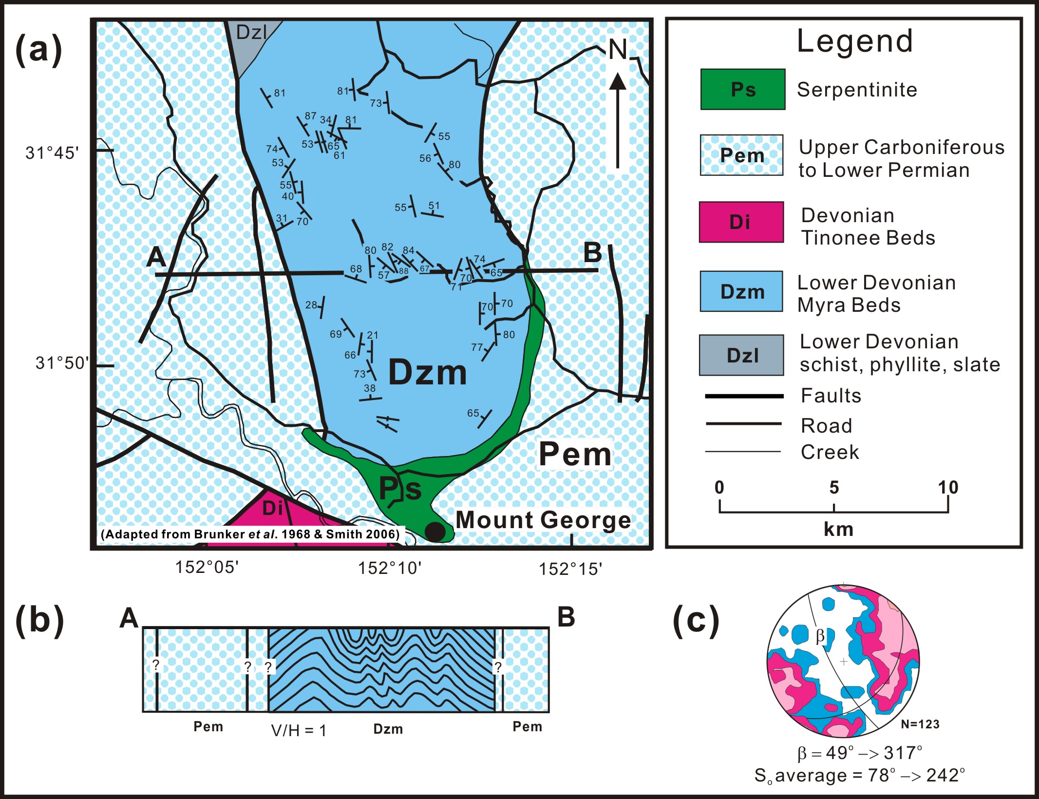
(2) The bedding in the subduction - accretion complex rocks north of Mt George where the hinge zone should be located, are variable but overall strike NNW and do not define a steeply-plunging macroscopic fold as expected for an orocline (Figure 2). The subduction-accretion complex rocks are deformed by moderately-plunging, tightly folded mesoscopic folds (Figure 2). Further, the structural grain south of Mt George in the hinge zone is oriented west-north-west, parallel to the Manning Fault in this region and does not bend around as expected for an orocline.
Figure 2. Mesoscopic folding of the Myra Beds north of Mt George.

a) Simplified geology map of the area north of Mt George in the so called hinge zone of the Manning Orocline.
The variably oriented but overall north-northwest striking, steeply southwest dipping Myra Beds are tightly folded on a mesoscopic scale. They are not folded around a steeply-plunging axis of rotation as expected in the hinge zone of an orocline. b) Cross section of the Myra Beds showing tight, mesoscopic folding as observed in the field. c) Contoured, lower hemisphere projection of poles to bedding for the Myra Beds consistent with an overall moderately northwest-plunging structure rather than a steeply plunging structure expected in the hinge of an orocline.
(3) The age of the Majors Creek Formation has been changed from Namurian (Roberts et al. (1995) to Visean in their paper. No evidence is given to support this re-assignment. This is important as the Hastings and Myall blocks show a similar change to dacitic volcanism and shallow-marine to continental deposition in the Namurian, suggesting they were in similar positions relative to the arc.
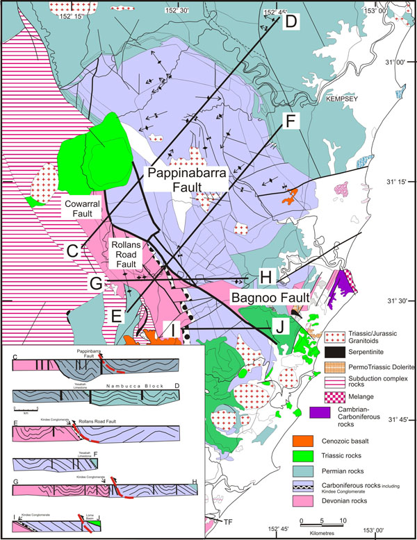
(4) The model proposed by Glen and Roberts (2012) for the development of the Hastings Block (in their appendix; p35-38) is not consistent with the observed geology. The Bagnoo Fault does not show evidence for thrusting as required by their model, rather sinistral strike-slip movement with the northeast side downthrown (Feenan 1984; Spackman 1989; Offler unpubl.). Further, the Parrabel Dome is considered by Glen and Roberts (2012) to be asymmetric with a steeply dipping, southwestern limb and more gently dipping northeast limb. The 1:100,000 data set on which this interpretation is based is a subset of the whole data set for this structure which is based on 1:25,000 sheets. Using the data recorded on the 1:25000 sheets, cross sections across the Parrabel Dome clearly show that it is an open, symmetrical structure (Figure 3).
Figure 3. Simplified geology map of the Hastings Block with cross sections to show the shape of the Parrabel Dome.
The dashed red line in each of the cross sections corresponds to the position and probably shape of the Bagnoo Fault as proposed by Glen and Roberts(2012). The Parrabel Dome is seen on these cross sections as an open, upright structure with a number of smaller folds across its crest. It is not an asymmetric hanging-wall anticline above the Bagnoo Fault as proposed by Glen and Roberts (2012).