Introduction
The Palaeozoic orogenic system in eastern Australia, in the area between Brisbane and Sydney, forms a number of tight bends (oroclines) (Figs. 1 and 2). The origin, and even the exact geometry, of these oroclines are still debated. Some authors argue that the structure is limited to a single Z-shaped bend known as the Texas-Coffs Harbour Orocline (Murray et al., 1987; Lennox and Flood, 1997; Offler and Foster, 2008). Others have suggested a more complex orogenic structure, comprising three bends (Korsch and Harrington, 1987) or even four bends (Cawood et al., 2011b; Glen and Roberts, 2012; Rosenbaum, 2012; Rosenbaum et al., 2012). The existence of such tight curvatures raises many questions related to the origin of the oroclines, their 3D geometry and continuation at depth, and the mechanism of oroclinal bending. These questions, which are largely still unresolved, have major implications on the way we interpret the evolution of the Australian continent and the way we understand deformation of the continental margin.
Figure 1. Location maps.
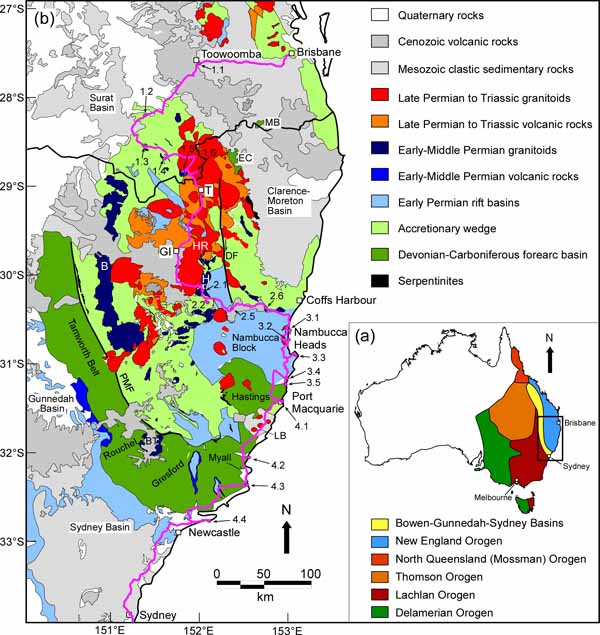
(a) Location map showing the Australian continent, the Tasmanides (coloured areas, after Glen, 2005) and the New England Orogen; (b) Geology of the southern New England Orogen. The field itinerary and stops are indicated in the purple line and circles, respectively (see also Figure 3). B, Bundarra Granite; BT, Barrington Tops Granodiorite; DF, Demon Fault; EC, Emu Creek Block; H, Hillgrove plutonic suite; LB, Lorne Basin; GI, Glen Innes; HR, Henry River Granite; MB, Mt Barney Inlier; PMF, Peel-Manning Fault System; T, Tenterfield.
Figure 2. Magnetic maps.
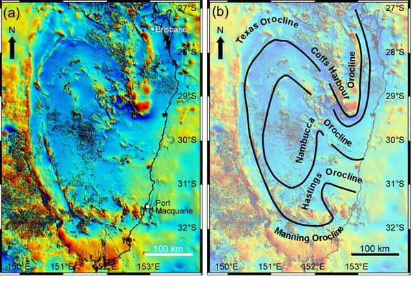
(a) Total magnetic intensity image of the southern New England Orogen (after Milligan et al., 2010). (b) Schematic interpretation of the major orogenic curvatures in the southern New England Orogen.
In this fieldtrip, we will examine the different geological entities that define the New England oroclines. We will see the pre-oroclinal tectonic elements, which predominantly originated in a Devonian to Carboniferous supra-subduction environment. We will also examine an earlier (Ordovician?) suture, which appears in a folded serpentinite belt. We will look at the assemblage of, possibly backarc-related, early Permian rocks, which seem to provide crucial information on the timing of oroclinal bending and associated geodynamics. We will make observations on a later phase of Permo-Triassic deformation and magmatism, and will discuss the origin of younger sedimentary and volcanic rocks.
The oroclinal structure, particularly of the Texas-Coffs Harbour Orocline, is clearly recognised in aeromagnetic images (Figure 2) and is expressed in the curvature of bedding and structural fabrics (Korsch, 1981; Lennox and Flood, 1997; Aubourg et al., 2004; Li et al., 2012a). The opposite-vergent oroclinal pair farther south, the Manning and Nambucca oroclines (Figure 2b), are somewhat more elusive. Their existence is supported by a number of independent criteria, such as the map-view curvature of early Permian granitoids, the contorted serpentinite belt and the arrangement of pre-oroclinal forearc basin terranes (Glen and Roberts, 2012; Rosenbaum, 2012; Rosenbaum et al., 2012). A number of authors, however, are sceptical, arguing that further evidence is required in order to support the existence of the Manning and Nambucca oroclines (Offler and Foster, 2008; Lennox et al., 2012). This fieldtrip itinerary includes a number of key observations related to this debate.
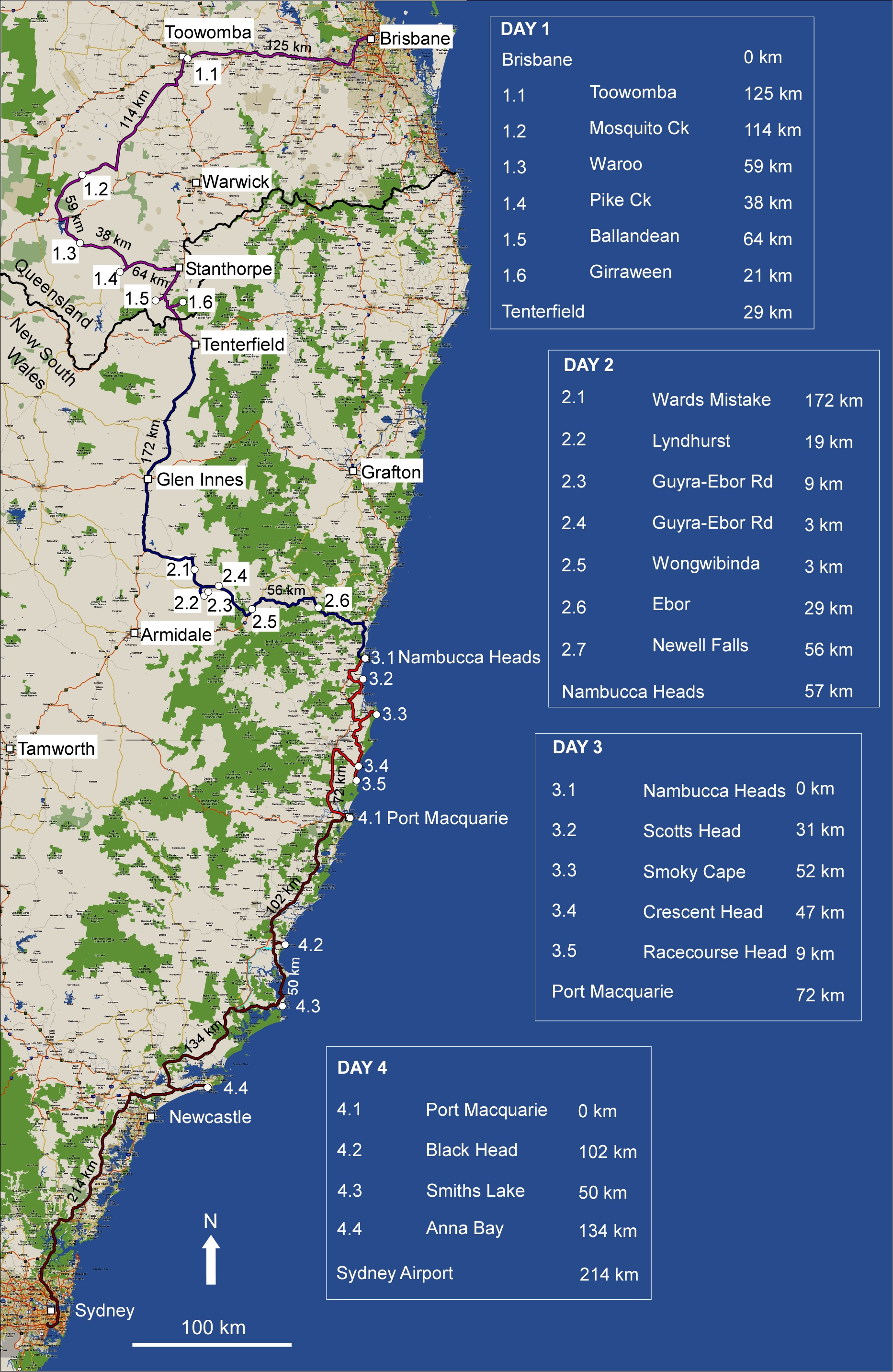
The fieldtrip is planned for 4 days. In order to allow an orogen-scale discussion, the itinerary covers a relatively large distance (total of >1400 km, including detours) and involves a few long driving legs (Figure 3). The first day is dedicated predominantly to the Texas Orocline. In the second day, we will visit early Permian, possibly backarc-related, S-type granitoids, and will traverse the high-grade Wongwibinda metamorphic complex. In the third day, we will see multiple generations of deformation in the early Permian Nambucca Block. Lastly, in the fourth day, we will examine serpentinites and high-pressure rocks at Port Macquarie, and will then travel south towards Sydney through a number of outcrops in the eastern limb of the Manning Orocline.
Figure 3. Field Trip itinerary.

Map showing the fieldtrip itinerary (source: Google Map). The itinerary is also available in Google Earth (kmz) format.