Day 4
Stop 4.1. Port Macquarie serpentinites and high-pressure rocks
GPS: -31.435876°/152.925736°
The coast of Port Macquarie provides a beautiful exposure of mafic and ultramafic rocks, including serpentinites and high-pressure assemblages. The origin of these rocks, possibly associated with an ophiolitic mélange (Aitchison et al., 1994), is Cambrian-Ordovician (Aitchison and Ireland, 1995; Fukui et al., 1995). A similar lithological assemblage occurs in a number of other localities throughout the southern New England Orogen (Figure 1b), most noticeably along the length of the Peel-Manning Fault System (Figure 1b). Farther south, the southwards continuation of the Peel-Manning Fault System is unclear, but patches of serpentinites are found in the area of the Manning Orocline and around the Hastings Block (Lennox and Offler, 2009). Therefore, it is possible that the same serpentinite belt that crops out along the Peel-Manning Fault System is folded around the Manning Orocline and the Hastings bend (i.e. Nambucca Orocline, Figure 2b) before reappearing in Port Macquarie. It is noted, however, that the correlation between the different serpentinite outcrops is not straightforward. For example, some of the ophiolitic-related rocks on the western side of the Hastings Block are probably Silurian-Devonian (Aitchison et al., 1994), i.e., considerably younger than the Cambrian-Ordovician Port Macquarie rocks.
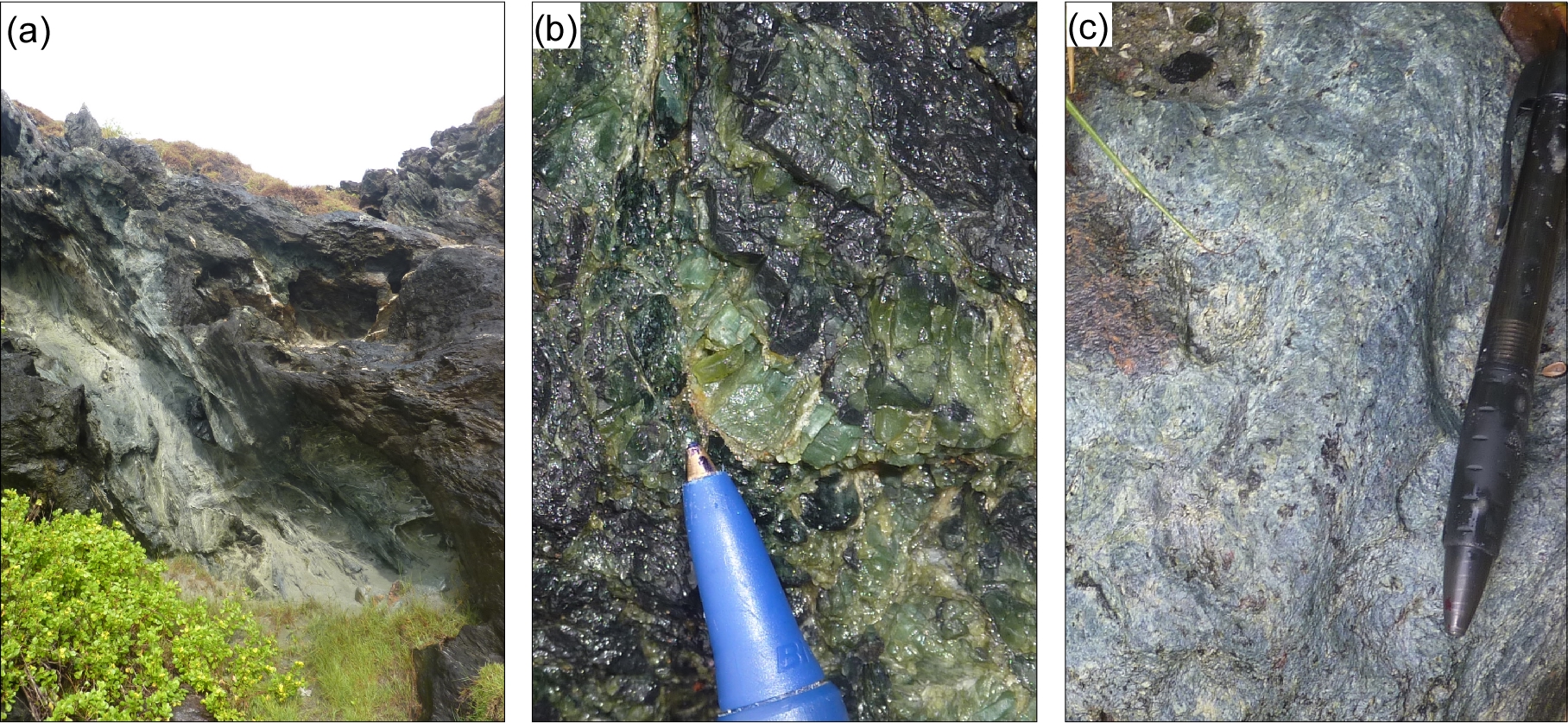
A detailed description of the geology of Port Macquarie has been provided by Och et al. (2003; 2007). The rocks are characterised by blocks of massive serpentinites and mafic rocks surrounded by a serpentinite schist (Figure 11a). The serpentinite assemblage in both blocks and matrix is lizardite and chrysotile (Och et al., 2007). Some of the blocks preserve cumulative textures and show primary magmatic layering. A protolith of harzburgite, lherzolite and orthopyroxenite has been suggested for the serpentinite blocks (Och et al., 2007).
Figure 11. Serpentinites and high-pressure rocks in Port Macquarie (for detailed geological maps see Och et al., 2007).

(a) Sheared serpentinite matrix surrounding blocks of massive serpentinite and high-pressure rocks. (b) Coarse-grained tremolite crystals; (c) A blueschist facies assemblage of glaucophane-phengite schist.
High-pressure rocks occur as blocks within a metamorphic mélange, and include retrogressed eclogite- and blueschist-facies metamorphic assemblages of almandine, omphacite, ±lawsonite, ±glaucophane and ±quartz (Och et al., 2003). Blocks of tremolite marble and omphacitite are also found (11b). Some layers of garnet-omphacite-lawsonite-quartz are intercalated with phengite glaucophane schist (Figure 11c). The matrix is chlorite-actinolite schist, most likely associated with metasomatic interactions between the mafic and ultramafic rocks.
Stop 4.2. Black Head
GPS: -32.070783°/152.547435°
Distance from previous stop: 102 km
Travelling south from Part Macquarie, we pass through Triassic strata of the Lorne Basin and Upper Triassic granitoids (Figure 1b) before approaching the Devonian-Carboniferous rocks of the Myall Block. Palaeomagnetic data indicate that the Myall Block, which is part of the forearc basin (Tamworth Belt), underwent 120° of counterclockwise rotations (Geeve et al., 2002). Such rotations around vertical axis could possibly be attributed to oroclinal bending in the Manning Orocline and the associated displacement of the Myall Block to a position at the southeast limb of the orocline.
The rocks in this locality belong to the Devonian Bundock beds. They are moderately dipping to the ENE. A fault striking ~200° is recognised, with kinematic indicators (tension gashes and minor folds) suggesting a sinistral sense of movement.
Stop 4.3. The Myall Block near Smiths Lake
GPS: -32.378914°/152.532545°
Distance from previous stop: 50 km
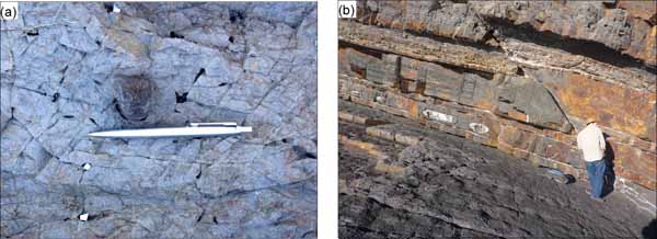
A series of headlands between Charlotte Head and Seal Rocks offer fine exposures of the Carboniferous forearc-related sedimentary package. At this locality, south of Danger Point, sandstone, siltstone and clay layers of the Wootton Beds are shallowly dipping (20°-25°) to the west, forming extensive dip slopes. Clasts of volcanic rocks (e.g. scoria) are found within the fine-grained clastic rocks (Figure 12a), indicating proximity to the volcanic source. Deformation is relatively weak, but a few E-verging reverse faults can be recognised (Figure 12b).
Figure 12. The Myall Block near Sandbar (Stop 4.3).
(a) Clast of scoria within siltstone (photo courtesy of Uri Shaanan); (b) minor E-verging reverse fault.
Stop 4.4. Nerong Volcanics in Anna Bay
GPS: -32.787639°/152.081216°
Distance from previous stop: 134 km
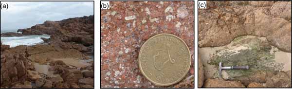
The Devonian-Carboniferous magmatic arc is rarely exposed in the southern New England Orogen, and is mostly inferred from provenance studies of the forearc basin (Tamworth Belt and correlative block). This locality provides the only real exposure of genuine Carboniferous volcanic rocks (Figure 13a) that possibly represent the actual volcanic arc (Buck, 1988). Based on U-Pb geochronology, the age of the Nerong Volcanics has been constrained at 338.6±3.8 Ma (Roberts et al., 1995a).
The rocks are ignimbrites, containing phenocrysts of quartz, K-feldspar and large weathered lithic fragments within a red groundmass (Figure 13b). Flow textures are not common, but there is evidence for the incorporation of large (~1 m) mafic blocks, metamorphosed to epidote-chlorite greenschist, and surrounded by ignimbrite (Figure 13c).
Figure 13. The Nerong Volcanics in Anna Bay.
(a) Exposures of ignimbrite slabs. (b) Fragments of quartz, K-feldspar and weathered lithic fragments in a red groundmass. (c) A block of epidote-chlorite metabasalt surrounded by ignimbrite.
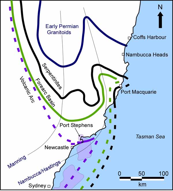
The exposure of the Carboniferous volcanic arc in this locality is consistent with the large-scale oroclinal structure (Figure 14). As recently pointed out by Glen and Roberts (2012), data from petroleum exploration suggest that pre-Permian volcanic rocks occur along a NNE-SSW belt offshore Sydney. The volcanic arc is exposed in the area around Port Stephens (i.e. Anna Bay), but does not continue northward into the Myall and Hastings Block. Rather, it is most likely underthrust beneath the Tamworth Belt farther to the northwest (Figure 14). The gentle curvature and sharp cusp in the volcanic arc were inferred to reflect the external hinge of the southern oroclines (Manning and Nambucca/Hastings), which progressively decrease their amplitudes from north to south (Glen and Roberts, 2012, Figure 14).
Figure 14. Tectonic interpretation of the Manning/Nambucca oroclines.
An orogenic-scale interpretation of the Manning and Nambucca (Hastings) oroclines, highlighting the reason why Carboniferous volcanic arc rocks (Nerong Volcanics) are exposed in Anna Bay. The inferred exposure of arc-related volcanic rocks offshore Sydney is after Glen and Roberts (2012). Onshore, Carboniferous arc volcanic rocks are interpreted to be underthrust beneath the forearc basin rocks.
The fieldtrip concludes in Sydney Airport, a distance of 214 km from the last stop.