Appendix A. Geology of the Hastings Block
The Devonian-Carboniferous stratigraphy of the Hastings Block (Fig. 5) is based on Roberts et al. (1995), with the latest Carboniferous-early Permian stratigraphy of Roberts et al. (1993) updated in Schmidt et al. (1994). These data show that the Hastings Block (Fig. 5a), which represents the core of the Hastings orocline, contains major facies changes, prompting the division into a northern and southern part that differ in pre-Permian stratigraphy (Roberts et al. 1995). The southern part has a mid-Devonian to Late Carboniferous stratigraphy similar to that of the Tamworth belt to the southwest. In contrast, the northern Hastings Block only contains Carboniferous and Permian units. Differences in Carboniferous Visean–Namurian stratigraphy reflect true facies changes as well as changes in outcrop nature from good in the south to poor in the north due to impenetrable tree cover. However, there are also many similarities between the two parts: for example, both parts show a changeover from mafic/intermediate to felsic volcanism at the base of the Namurian, above a regional unconformity or disconformity.
The Hastings Block is separated from Devonian strata of the Tamworth belt by the ENE-trending Taree fault (Figs. 3, 5a). Northeast of that fault, the Hastings Block is surrounded by subduction complex rocks to the west and to the east at Port Macquarie, but elsewhere by Permian strata to the north and southwest, and by Triassic strata to the southeast (Fig. 5a). The Hastings Block possesses a complex internal structural geometry that has been divided into several domains (Lennox and Roberts 1988; Roberts et al. 1995; Lennox et al. 1999). Lennox and Roberts described the complex geometry in terms of formation of east-west S1 cleavage (best seen in the Nambucca Block to the north) that has been folded round the D2 Parrabel Anticline which has then been overprinted by D3 folds. The crestal area in the Boonanghi beds contains open and upright folds with half wavelengths of ~2 km that may represent refolded D1 folds (Lennox and Roberts 1988).
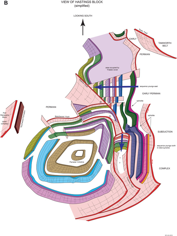
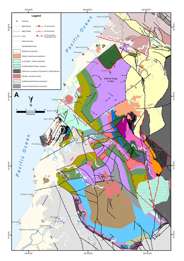
Figure 11 presents our structural re-interpretation of Figure 5. The variably plunging Parrabel anticline (Lennox and Roberts 1988) that dominates the northern part of the Hastings Block, appears to fold earlier thrust and folds, and contrasts with a NNW-trending, east younging sequence to the west and southwest. Our preferred interpretation is that the anticline has thrust over this sequence from the east (Fig. 11a, b) and lies in the hangingwall of an east-dipping thrust that has partially reactivated older thrusts. In this interpretation, the Parrabel anticline is a D2 hangingwall fold that may have nucleated on an earlier D1 structure. The north-plunging hinge of the Parrabel anticline is defined by a north-younging stratigraphy passing up from Boonanghi beds through Majors Creek Formation into the Kullatine Formation and Youdale (C) Formation, and locally into the Warbro Formation, that have been folded around several angular hinges that plunge to the north, west and east. Dips in the Late Carboniferous strata range from 50-35° and in the early Permian 60 to 28° (unpublished data, Roberts et al. . The south-plunging, southern hinge of the Parrabel anticline is outlined by the south-younging sequence of Pappinbarra Formation, Hyndmans Creek Formation, and in the southeast, the Mingaletta Formation. Individual dips occur to both north and south (and to the east and west in the limbs) and are interpreted as reflecting the presence of east-west D1 km scale folds (figure 2 of Roberts et al. 1995).
Figure 11. Hastings Block interpretation

A. South-looking interpretation map of the Hastings Block, highlighting major thrusts, and based on Roberts et al. (1995, figure 2) and on Fig. 5a of this paper. Southward-looking orientation is designed to simplify comparison with the block diagram in B. B. Three-dimensional sketch of the Hastings Block, looking south, showing the Parrabel anticline as an asymmetrical hangingwall D2 anticline above an east-dipping D2 thrust, with older D1 thrusts folded around the anticlinal hinge. Left-lateral strike-slip on thrust faults separating the western part of the Hastings Block from subduction complex rocks to the west based on Lennox and Offler (2009). Inferred east-block up displacement is inferred on the LIF fault separating subduction complex rocks of the Port Macquarie block from the eastern part of the Hastings Block. Abbreviations: BWF=Beechwood fault; CWF= Cowarral fault; LIF=Lake Innes fault; PAF=Pappinbarra fault; RRF=Rollans Road fault. For units and abbreviations, see Figure 5.
Our view of the Parrabel anticline is based on the interpretative map (Fig. 11a) and the block diagram (Fig. 11b), both looking southward. Figure 10b shows that the D2 Parrabel anticline is asymmetrical, with a steeply dipping western limb and a more shallowly dipping eastern limb. Based on our interpretation of stratigraphy, the D2 anticline also folds two south-dipping thrusts that root down into Devonian strata, and are thus also of D1 age (Fig. 11a, b). The northernmost thrust (labelled 1 in Fig. 11b) has a footwall of folded Hyndmans Creek Formation passing around the hinge of the Parrabel anticline, although in the eastern limb it cuts down section across a lateral ramp so the footwall is only the Pappinbarra Formation. The hangingwall mainly comprises the Pappinbarra Formation, probably containing a hangingwall anticline (J. Roberts unpublished mapping), but locally the older Nevann Siltstone. The thrust is shown as folded around the hinge of the Parrabel Anticline and cut off on the east by a west-dipping thrust, partly against early Permian strata. In the west, this fault is called the Pappinbarra fault (PAF). Its footwall contains a north-younging, steeply (~70°) north-dipping sequence that passes up-section from the Nevann Siltstone into Mingaletta Formation. This fault–bounded north-dipping sequence occupies a relict (D1) synclinal hinge (Fig. 11b). It is possible that the eastern margin of this hinge originally dipped to the west and has been partially reactivated as an east-dipping thrust in D2 times. The southern most D1 thrust (labelled 2 in Fig. 11b) lies south of the first and is shorter. It is cut off to the east by a NNW-trending, west-dipping post-early Permian thrust, and on the west by an east-younging, west-dipping sequence. This folded thrust juxtaposes Mingaletta Formation against a hangingwall ramp of folded strata that pass down section from Pappinbarra Formation in the east into Wallibree Formation in the west.
The western part of the Hastings Block consists of an east-younging Devonian-Carboniferous sequence that passes from the Yarras ophiolite and the Devonian Bitter Ground Volcanics up into the Carboniferous Mingaletta Formation (Figs. 5, 11a). The bounding fault against subduction complex rocks to the west is shown as an east-dipping thrust (Fig. 11b), with a component of left-lateral movement based on data of Lennox and Offler (2009). (These authors suggested that kinematic histories of serpentinites along major faults on the margins of the Hastings Block postdated emplacement of the block itself.) This sequence lies west of and below the east-dipping major Bagnoo fault and its inferred extensions, the Rollans Road fault (RRF) and the Cowarral Fault (CWF), both of which are inferred to be reactivated D1 thrusts, and is structurally bound to the west by the Taree fault and by subduction complex rocks (Figs, 5, 11a, b). Both figures suggest that south-vergent fold pairs in the Cowangara and Birdwood formations accommodate the fault-bounded relict synclinal hinge referred to above. Stratigraphic separation on the Bagnoo fault dies out southward, so that in the southern part, the Late Carboniferous Mingaletta Formation is juxtaposed against Triassic strata (Roberts et al. 1995 Fig. 2; Pratt 2010, map 1) (Fig. 11a). This east-younging package is truncated at its southern margin by the ENE-trending unnamed fault partly overlapped by Triassic strata. South of this fault and northeast of the Taree fault (Fig. 5a), Triassic strata, which have been intruded by Late Triassic-Early Jurassic intrusions, outline an open an east-younging syncline-anticline pair plunging to the southeast (Roberts et al. 1995; Pratt 2010). Joining small scattered outcrops of Palaeozoic strata (Fig. 11a) suggests this part of the Hastings Block is occupied by the very wide Pappinbarra Formation that passes up section through the Hyndmans Creek Formation into the Mingaletta Formation. While stratigraphic repetition suggests the presence of a possible fold or imbrication in this area, available dips suggest a faulted contact with south-dipping Devonian Cowangara Formation bounded to east and west by younger strata (Fig. 11a).
On the eastern edge of the Hastings Block, the Mingaletta Formation passes eastwards into the Givetian Mile Road Formation and the Emsian Touchwood Formation, one slice of which is separated from the main part of the block by the early Permian overlap assemblage (Figs. 5, 11a). This slice is in fault contact to the east with subduction complex rocks of the Port Macquarie Block that include high-level, volcaniclastic broken formation, containing Ordovician cherts (Watonga Formation, Och et al. 2007a) and serpentinite matrix melange, enclosing various blocks including high grade metamorphic schists, (Och et al. 2007b). Permian-Late Triassic gabbro and dykes stitch the two blocks and the Permian overlap assemblage (Och et al. 2007b). Note that this description differs from that of Roberts et al. (1995) and Leitch et al. (1990) both of which include the Touchwood Formation in the Port Macquarie block.
In the hinge and northeastern limb of the Parrabel anticline, early Permian shallow water strata pass north-eastwards across faults into deeper water strata that comprise the multiply deformed and metamorphosed fill of the early Permian Nambucca rift basin (Lennox et al. 1999).
