Introduction
The Main Central Thrust zone (MCTZ), one of the largest ductile shear zones currently known from any collisional orogen, is certainly one of the most debated tectonic features of the Himalaya (e.g. Searle et al., 2008; Goscombe et al., 2006 and references therein). The MCTZ is a north-dipping crustal-scale thrust zone, east-west striking for more than 2000 km throughout the whole Himalayan chain and characterized by a thickness ranging from ~100 m to several km. This major structure controlled the south-verging juxtaposition of the high-grade metamorphic rocks of the Higher Himalayan Crystallines (HHC) over the low-grade to non-metamorphic rocks of the Lesser Himalayan Sequence (LHS) (Fig. 1; Heim and Gansser 1939) and accommodated, upon the early Eocene, more than 100 km of crustal shortening (e.g. Schelling and Arita, 1991; Hodges, 2000) in the regional tectonic framework of the Asian and Indian plates collision (e.g. Le Fort, 1975).
Since the first detection and field mapping of this structure (Heim and Gansser 1939), a very rich literature illustrated its geological features across the whole Himalayan chain. Moreover, because of its significant lateral extension and consequent local variations, and because of a variable exposure due to vegetation and Quaternary cover, the precise identification and interpretation of the MCTZ are still object of debate, as well as the interpretation and origin of its associated (and largely documented) inverted metamorphism (e.g. Le Fort, 1975; Arita, 1983; Pêcher,1989; Searle and Rex, 1989; England and Molnar, 1993; Guillot, 1999; Harrison et al. 1999; Stephenson et al., 2000; 2001; Goscombe et al., 2006; Searle et al., 2008; Groppo et al., 2009 and references therein). Notably, in the Main Central Thrust Zone and its contiguous domains, the metamorphic grade increases from the lower to the upper structural levels, passing from the Bt-Chl zone in the LHS to the Sil-Kfs zone with extensive anatexis in the HHC.
Most of the published studies about the MCTZ are addressed to better define: i) its structural features (i.e. if it consists of one or more thrust faults, structural boundaries, ductile vs. brittle evolution), and ii) an accurate quantitative estimate of the metamorphic evolution and its relationship with the structural history. These are in fact key points for the development of any tectonic model aimed to the interpretation of the evolution of the Himalayan belt (e.g. Harrison et al., 1999; Beaumont et al., 2001, 2004; Grujic et al., 2002 and references therein).
This paper deals with the Kanchenjunga area, located in the far-eastern Nepalese Himalaya, where the LHS outcrops as an tectonic half-window beneath the HHC (Fig. 1). This area is poorly known with respect to other sectors of the Himalayan chain, so far having been investigated in some detail by very few groups (Schelling and Arita, 1991; Schelling, 1992; Goscombe and Hand, 2000; Goscombe et al., 2006; Imayama et al., 2010). In 2009, an extensive field mapping, combined with structural and petrografic investigations, was done along the Tamor-Ghunsa Khola and the Simbuwa-Kabely Khola transects, crossing the Mirgin La to join them (Fig. 2). The main data of this fieldwork have been preliminarily illustrated and qualitatively discussed in a recent paper (Mosca et al., 2011), mainly focused on the description of the most relevant meso- and micro- structural features of the area. The purpose of this novel contribution is to present new and more detailed quantitative data from the MCTZ and its contiguous domains, emphasizing the relationship between its structural evolution and metamorphic P-T conditions. Field investigations, meso- and micro-structural data were thus integrated with mineral chemistry data acquired on the most representative samples and with thermobarometric calculations. Moreover, the obtained results are compared with those previously obtained westward by our research group (Milke Danda transect: Groppo et al., 2009) at similar structural levels, and discussed in the framework of the tectono-metamorphic architecture of this sector of the Himalayan chain.
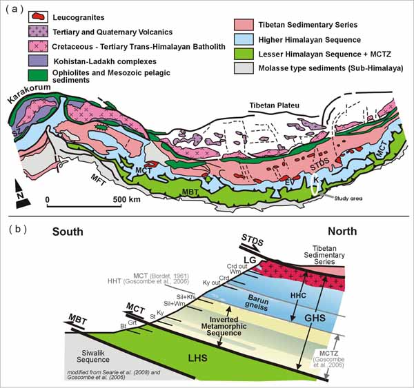
Figure 1. Map and schematic of the study area
(a) Simplified tectonic sketch map of the Himalaya (redrawn after Dietrich and Gansser, 1981). The investigated area is outlined by the white ellipse. (b) Schematic cross-section across the Eastern Himalaya (modified from Goscombe et al., 2006 and Searle et al., 2008). EV, Everest; HHT, High Himal Thrust; K, Kangchenjunga; LG, leucogranites; LHS, Lesser Himalayan Sequence; MBT, Main Boundary Thrust; MCT, Main Central Thrust; MCTZ, Main Central Thrust Zone; MFT, Main Frontal Thrust; STDS, South Tibetan Detachment System; SZ, Indus/YarlungTsangpo Suture Zone. Mineral abbreviations for isograds are after Whitney and Evans (2010).
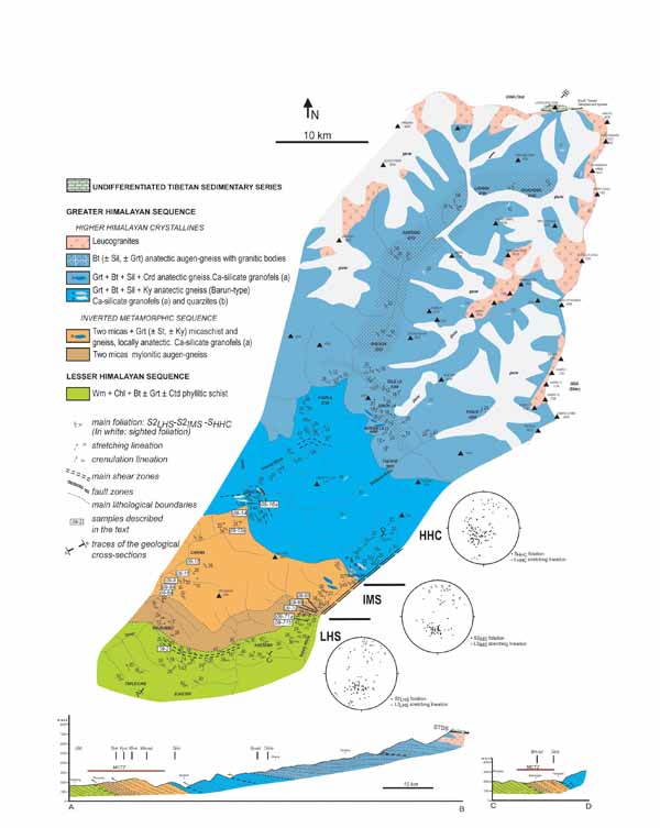
Figure 2. Geological map and representative cross-sections of the western Kangchenjunga region (modified from Mosca et al., 2011).
Stereoplots (Lower hemisphere equal-area projections) show the orientation of pervasive foliations and lineations in the LHS, IMS and HHC. See text for further explanations. Samples studied in this paper are reported in the map.