Introduction
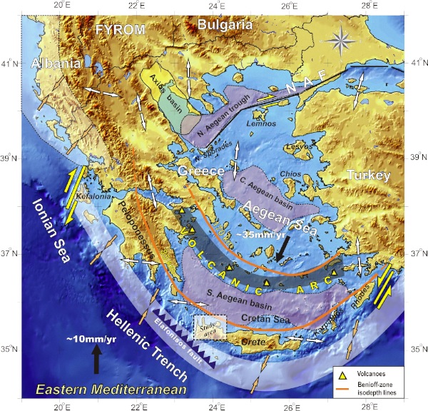
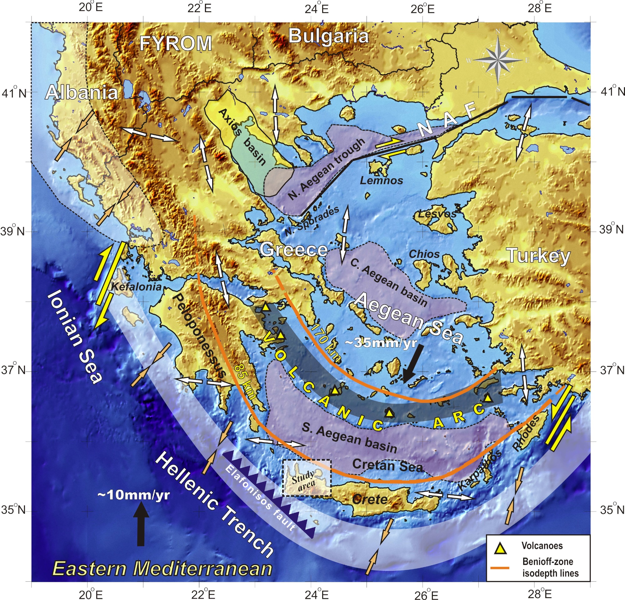
The study area of Western Crete is located in the Southern Aegean subduction zone, which includes the outer Subduction Arc (Crete, Peloponnesus, Rhodes, etc.) and the inner Volcanic Arc (fig 1). The seismotectonic features of the broader Southern Aegean area are controlled by the presence of a complex subduction of the Eastern Mediterranean lithosphere beneath the Aegean Sea lithosphere, as well as the interaction of the Aegean, Anatolia and Eastern Mediterranean lithospheres (e.g. Papazachos and Comninakis, 1970, McKenzie, 1970, 1972, Le Pichon and Angelier, 1979). This complicated geodynamic interaction has imprinted itself on the observed geological and seismotectonic setting. A typical example is the presence of different types of stress-regimes and corresponding faulting, often with spatial overlapping (e.g. Papazachos et al., 1998), including: a) Large thrust submarine faults located along the outer Hellenic arc (e.g. south western part of Crete) due to the NE-SW convergence compression, b) Medium N-S trending normal faults, located either on land or along the western and eastern borders Crete, Karpathos and southern Peloponnesus due to an arc-parallel E-W extension field, c) Large-to-medium E-W trending normal faults throughout the main part of the Aegean Sea and the Greek and Turkey mainland, corresponding to a roughly N-S trending extension and, d) Right and left-lateral strike-slip faults along the broader Kefalonia and Rhodes area, respectively, defining the external borders of the Aegean lithosphere, which exhibits a SW plate motion of the order of 35mm/yr with respect to stable Eurasia (Oral et al., 1995, Reilinger et al., 1997, Papazachos, 1999, McClusky et al., 2000). Moreover, a well developed Benioff zone is observed (e.g. Papazachos et al., 2000), with medium-to-large transpressional intermediate-depth events, mainly occurring in the depth range of 60-90km, with maximum depths of the order of 180km. The subduction is associated with an active Volcanic Arc (e.g. Fytikas et al., 1984), with the volcanic centre of Santorini in Central Cyclades, being the most active volcano of the area.
The island of Crete is situated in a fore-arc position above the active northward-directed subduction zone of the African plate beneath the Aegean plate (Petereck and Schwarze 2004). Crete is a structurally complicated area (fig. 2, 3), been strongly affected by the Alpine orogenic processes in Eastern Mediterranean from Jurassic to present day, due to plate convergence of Eurasian and African plates and the subduction of the Tethyan oceanic crust (Bonneau 1984, Lister et al., 1984, Mountrakis 2006, Ring et al., 2010, Kilias et al., 2010). Nappes stacking and compression alternate with extension, nappes collapse and exhumation of deep crustal rocks (fig. 3; Bonneau 1976, 1984, Seidel et al., 1982, Kilias et al., 1994, 2002, Jolivet et al., 1996).
The convergence of Eurasian and African plates in Eastern Mediterranean region and the subduction of the later beneath the former in the Hellenic arc from Late Oligocene until now, resulted in the intense neotectonics and active deformation in Aegean area, in Crete and in the whole internal Hellenic region (Kilias et al. 1994, Jolivet et al., 1996, ten Veen & Kleinspehn 2003). This deformation is displayed as continuous expansion and thinning of the Aegean crust (Goldworthy et al., 2002) and is revealed by the creation of new, as well as the reactivation of older major faults, which are responsible for the formation or reorientation of large Neogene - Quaternary troughs. This active deformation is also presently manifested by the occurrence of strong shallow earthquakes along the Hellenic Arc, including the broader area of Crete. In general, the largest seismicity levels are observed along the outer Hellenic arc (south of Crete), within the NE-SW compression zone due to the Aegean-Eastern Mediterranean convergence (fig. 1). A typical case is the major Elafonisos fault, schematically depicted in figure (1) after Papazachos et al., (2001), that has hosted the 365BC M = 8.3 event (Papazachos, 1990, Stiros, 2001, Shaw et al., 2008), which is the largest known earthquake in the Aegean-Mediterranean convergence system.
Although several works have been published regarding the Miocene to Late Pliocene structural evolution of Crete based on the tectonostratigraphic column of the Neogene sediments and detail structural analyses (Kilias et al., 1994, Fassoulas et al., 1994, Jolivet et al., 1996), information on the Late Pliocene to recent tectonic evolution and the corresponding fault activity (active or not faults) and their kinematics of Crete are much less available, with a limited number of publications on the Pliocene – Post-Pliocene brittle tectonics (e.g. Meulenkamp et al., 1994, Duermeijer et al., 1998, ten Veen & Meijer 1998, ten Veen & Kleinspehn 2003). The better understanding of the structural conditions under which this younger crustal deformation takes place is important for
Figure 1. Schematic geotectonic map of the broader Aegean area
Plate motions in the southern Aegean area are depicted by solid vectors, while the local stress field is shown by double open arrows. The major Elafonisos thrust fault affecting the study area, as well as the main strike-slip zones (North Anatolia Fault-NAF, Kefallonia and Rhodes), the volcanic arc and the Benioff-zone isodepths are also presented (modified from Papazachos et al. 1998, Karagianni et al. , 2005).
theoretical, as well as for practical reasons (e.g. seismic risk mitigation policy in Crete), since these active structures are related to the medium-to-strong seismic activity on the island.
Our study focuses in the region of Western Crete (fig. 1). Within the framework of this study, the complicated fault system of Crete was mapped in detail and its kinematic and dynamic setting was analyzed, in order to distinguish the major active, possible active and geological (inactive) fault zones. The field study was completed by the analysis of fault-slip data recognized mainly along the main fault zones that dominate the study area. For the calculations we employed the slickenlines orientations and fault plane data (strike, dip direction and dip angle), as well as kinematic indicators (such as offsets, riedel fault, steps, folds, etc.) to determine the slip vector and the sense of movement (Hancock 1985). Furthermore, overprinting relationships based on the intersection of slip striae or displacements from earlier faults, as well as the stratigraphic age of the sediments that have been affected (or not) by the fault activity were used to distinguish fault generations of different age or different tectonic events.