V. THE PINDOS FOLD AND THRUST BELT
Tectonic inversion of the Pindos basin was achieved by compression-induced shortening, which created the Pindos fold-and-thrust belt, a belt that can be traced north-south through western Greece (Wagreich and others, 1996; Doutsos and others, 2000; Skourlis and Doutsos, 2003) (Figure 8). The Pindos sedimentary sequence experienced significant shortening (Degnan and Robertson, 1998; Doutsos and others, 2000; Skourlis and Doutsos, 2003) (Figure 9A). Based on detailed geological mapping and analysis of folds and thrust faults within the Pindos belt overall, Skourlis and Doutsos (2003) concluded that tectonic shortening in excess of 50% was achieved through a combination of layer-parallel shortening, thrust faulting, and buckling (Figure 9B). The net effect was fault imbrication of the sedimentary sequence. Strata within each panel became folded in a way determined by the shapes of the major thrust faults along which the beds were transported and the distance of tectonic transport, typically measured in kilometers. During thrusting and folding, the Pindos Group strata were structurally thickened, and became elevated.
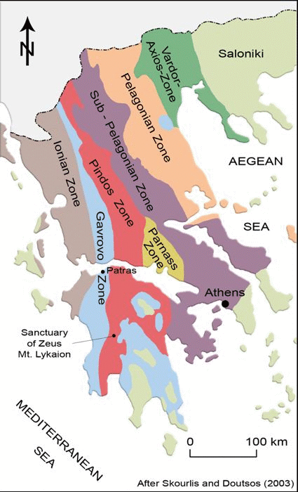
Figure 8. Map of tectonic provinces in Greece.
Map showing the Pindos fold-and-thrust belt, which runs north-south across all of Greece. Adapted from Walreich and others, 1996, figure 1, p. 325.
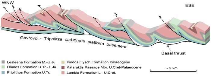
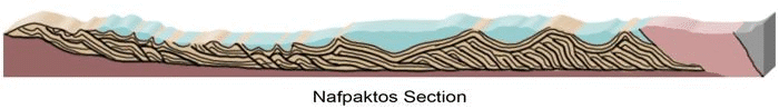
Figure 9. Pindos Belt folding and thrusting.

A. Structure section showing overall style of deformation by thrust faulting and folding in the Pindos Zone fold and thrust belt. From Degnan and Robertson, 1998, figure 3, p. 37).
B. Structure section showing the details of thrust faulting, imbrication, and folding. This is an east-west structure section that crosses the Pindos fold and thrust belt just north of the Gulf of Corinth in the Navpatkos region. From Skourlis and Doutsos, 2003, figure 3, p. 895.
The resulting Pindos mountain system, as it emerged, became subject to erosion, with the erosion-derived sediments transported by streams and currents to sites of both non-marine and marine deposition. The sediment influxes contributed to forming the syn-orogenic sediments that became the upper part of the Pindos Group (Walgreich and others, 1996; van Hinsbergen and others, 2005; Degnan and Robertson, 2006; and Piper, 2006). As the Pindos basin continued to close, folding and thrusting shortened these freshly minted sediments as well.
The direction of tectonic transport within the belt was from ENE to WSW, along a line perpendicular to the overall NNW/SSE trend of the Pindos fold-and-thrust belt (Degnan and Robertson, 1998; Skourlis and Doutsos, 2003). The thrust panels of Pindos Group sedimentary rocks are allochthonous and now reside tens of kilometers west of where they were originally deposited (van Hinsbergen and others, 2005). But the story is even more complicated. Following the tectonic development of the Pindos fold-and-thrust belt, the whole belt experienced a 50º clockwise (vertical axis) rotation. Restoring the rotation makes it clear that the original tectonic transport direction for the Pindos belt actually was north to south.