Crustal source of EGB
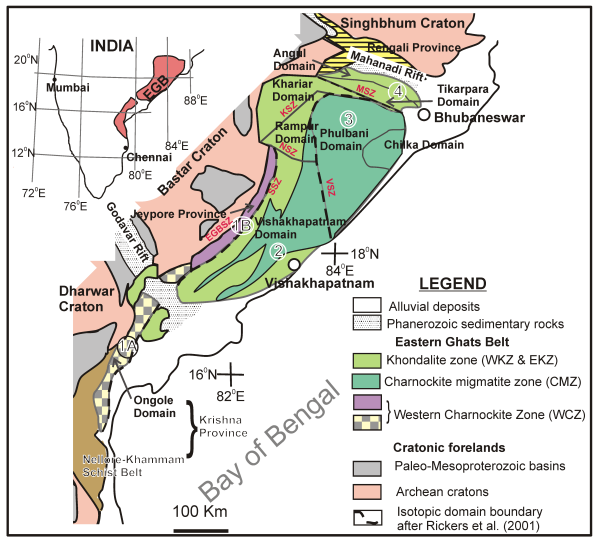
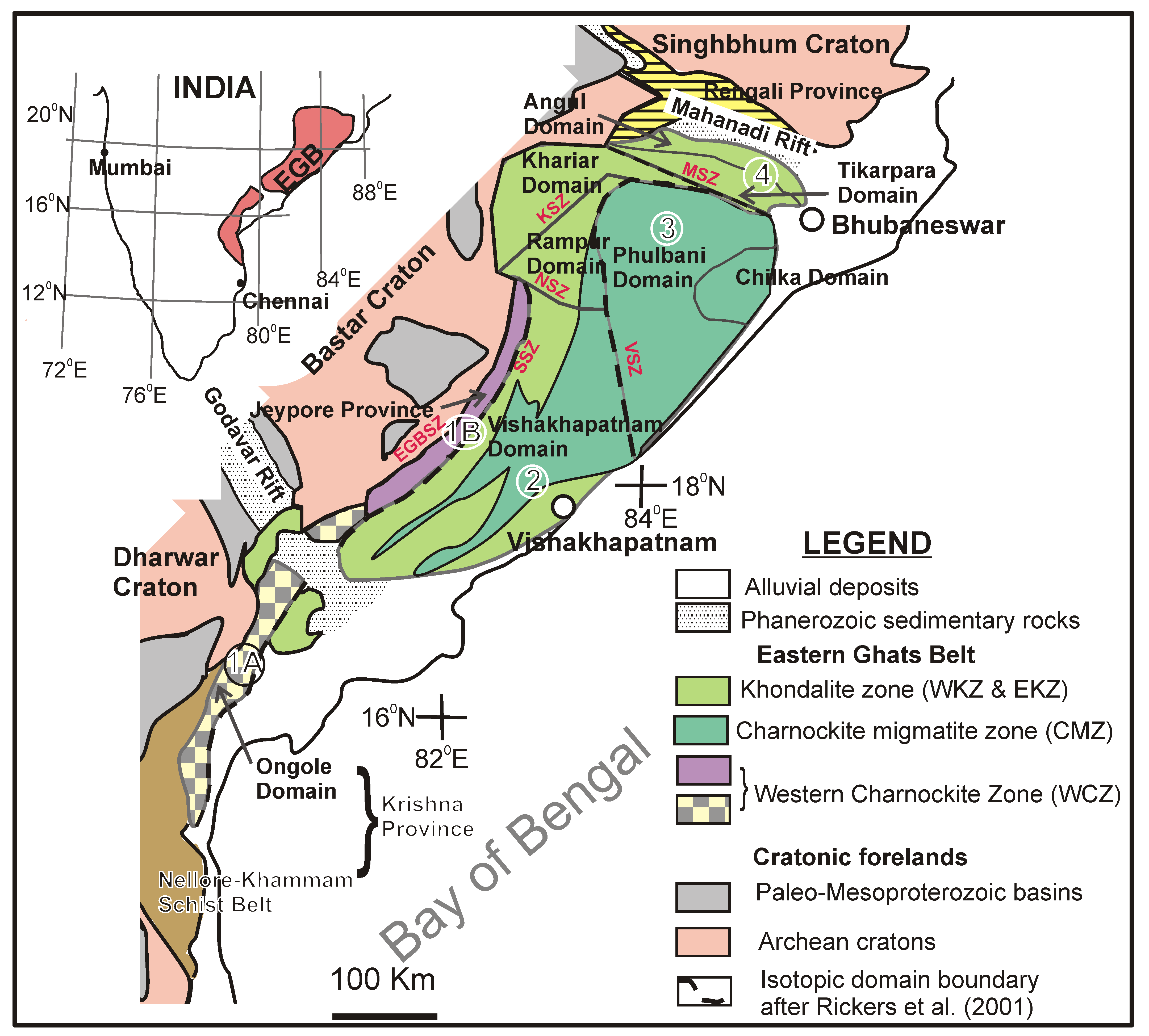
The unique feature of EGB is that the entire belt is composed of high-grade granulites with minor lower grade rocks. The high-grade granulites consist of supracrustal rocks and intrusives of diverse chemistry. In an attempt to frame a lithological map, Ramakrishnan et al. (1998) introduced a four-fold longitudinal subdivision viz. Western Charnockite Zone (WCZ), Western Khondalite Zone (WKZ), Central Migmatite Zone (CMZ) and Eastern Khondalite Zone (EKZ). Additionally, their work invoked the existence of a Transition Zone (TZ) separating EGB from the adjacent Bastar Craton (Fig. 1). Despite being a pioneering effort, later petrological and isotopic data do not exactly comply with this scheme and reveal a more complex scenario. Rickers et al. (2001) carried out Nd-mapping over a large part of the EGB and based on Sm-Nd, Rb-Sr and 207Pb-206Pb isotopic data, subdivided EGB into four crustal domains whose boundaries do not match with those of Ramakrishnan et al. (1998). Domain 1 broadly coincides with WCZ and is subdivided into 1A and 1B based on positions with respect to the Godavari Rift (Fig. 1). Domain 1A is situated at the southern end of Godavari Rift and is characterized by homogeneous Nd-model ages for the paragneisses (2.8-2.6 Ga) and orthogneisses (2.5-2.3 Ga). Domain 1B is situated in the north of Godavari Rift and is characterized by older crustal protolith (3.9-3.2 Ga age for orthogneisses). Domain 2 consists of CMZ and EKZ and shows very complex isotopic characters. Metasediments have Nd-model age of 2.5-2.1 Ga, while the orthogneisses have a wide Nd-model age spanning 3.2-1.8 Ga. Earlier, Sengupta et al. (1999) had pointed out the differences in the history of petrological evolution of granulites occurring to the north and south of the Godavari rift. Domain 3 is situated north of Domain 2 and shows fairly homogeneous Nd-model age (2.2-1.8 Ga for both metasediments and orthogneisses). This domain has more juvenile addition compared to the others. Domain 4 is situated at the extreme northern part with Nd-model age of 3.2 Ga for the orthogneisses and 2.8-2.2 Ga for the metasediments. The essence of this subdivision of EGB is that the protolith history of all the four crustal domains is contrasting. The sources of the sediments deposited on a basement (of unknown age) are the adjoining Archean cratons, while small but variable quantities of juvenile material was added during Proterozoic-age orogenies. Dobmeier and Raith (2003) conceptualized EGB into four crustal provinces (instead of four domains) based on isotopic data of Rickers et al. (2001) combining with available petrological, structural and other geochronological data. Accordingly, the Jeypore Province and the Krishna Province, equivalent to Domains 1B and 1A of Rickers et al. (2001) respectively, are excluded from the sensu-stricto Eastern Ghats Province. The latter (combining Domains 2 and 3) consists of several domains with slightly contrasting protolith histories, all of which share a strong tectonothermal history in the Neoproterozoic time (~1000-500 Ma). The fourth one, the Rengali Province representing the Domain 4 has crustal antiquity similar to the adjoining Singhbhum Craton and available petrological data also allow its exclusion from the Eastern Ghats Province. According to them, therefore, only the Eastern Ghats Province bears the unique tag of representing a mobile belt, while the status of the other three provinces remains uncertain. It is not clear from the available data whether evidenc of an earlier orogeny are concealed within the belt which might have wider implication in crustal evolution. Several studies (e.g. Gupta, 2004) questioned the validity of such a classification, owing to the fact that different criteria were used to subdivide the EGB. Complexities do exist in crustal provenance (metamorphic and intrusive ages, P-T paths and structural styles) that pose serious problems. One important aspect of this kind of domainal or provincial classification of EGB is the nature of the mutual boundaries. Several workers (Chetty, 2001; Chetty et al., 2003; Biswal and Sahoo, 1998) identified mega-lineaments in EGB from satellite imagery data albeit with limited ground checks. These lineaments broadly follow the river courses along the domain/province boundaries. Limited structural data (e.g. Chetty et al., 2003) suggest such lineaments as ductile shear zones. However, lack of detailed structural, petrological and, most importantly, geochronological data do not allow one to test the nature of such domain/province boundaries.
Figure 1. Domainal divisions of Eastern Ghats Belt
Domainal divisions of Eastern Ghats Belt, India and adjacent crustal terrains (modified after Dobmeir and Raith (2003)). Encircled numbers represent the isotopic domains following Rickers et al., (2001). Lithological divisions of EGB are based on Ramakrishnan et al. (1998). Crustal provinces and domain names of EGB are after Dobmeir and Raith (2003). EGBSZ- Eastern Ghats Boundary Shear Zone, SSZ - Sileru Shear Zone, VSV - Vamsadhara Shear Zone, NSZ - Nagavalli Shear Zone, KSV - Koraput-Sonapur Shear Zone, MSZ - Mahanadi Shear Zone.