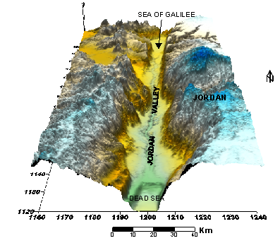
Jordan valley
The Jordan Valley is a morphotectonic depression that extends from the northern shoreline of the Dead Sea to the Sea of Galilee. This depression is bordered on the eastern and western sides by faults and flexures. The Bouguer gravity data indicates that the character of the plate boundary changes to the north of the Dead Sea (ten Brink et al., 1999; ten Brink, et al., 2001; Al-Zoubi et al., 2006). The Jordan Valley comprises several separate small basins (Jericho (Shuna) basin, Damia, Bet-Shean and Bakura).
The Jericho basin plunges westward and terminates against a west dipping strike-slip fault. A buried monocline parallel to the fault segment was found and served as independent evidence for a local compression (Rotstein et al., 1991). Recently, Al-Zoubi et al. (2006) found the same kind of structure on the Jordan side and called it the Al-Kharar monocline. They suggested that this is a young active structure which formed as a result of compression in the Shuna area due to the motion along the transform fault. In addition, several normal active faults were also found within the valley.
The Damia basin is a shallow and complex structure with several parallel faults at the edge and within the basin. The Bouguer (ten Brink et al., 2001) and the seismic data (Ben-Menahem, 1991; ten Brink et al., 1999; Al-Zoubi et al., 2006; ten brink et al., 2006) show that the major fault is buried under a few hundred meters of sediments where the surface geology and the abrupt stream course-change indicate the recent activity in the area (Garfunkel, 1981).
The Bet-Shean basin, as a part of Mallaha structure (middle part of the Jordan Valley), was formed under transpression resulting from lateral slip combined with friction and pressure in this area (Belitzky, 2002). The transpression in this area produced counterclockwise rotation of the major fault. This rotation is combined with lateral slip on the east-west faults.
Figure 1b. Shaded relief topography image of the Jordan Valley Basin
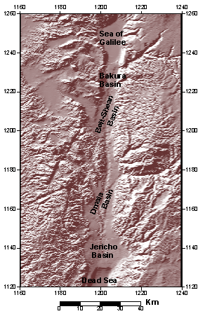
Shaded relief topography image of the Jordan Valley Basin showing the sub-basins from digital terrain model (Hall, 1993). Coordinates are in Cassini Palestine grid
The Jordan Valley consists of flood plain of the Jordan River and the Jordan valley floor. The basin represents the Jordan Valley Rift with pronounced geologic depression recording elevation ranges from 200m to 400m below sea level. Although, several geological and geophysical studies have been performed along the Jordan Valley, but the subsurface structure of the basin is still not well understood (e.g., ten-Brink and Ben-Avraham, 1989; Frieslander et al., 1995; Al-Zoubi and ten-Brink, 2001; Al-Zoubi and ten-Brink, 2002). The Jordan Valley Rift is a part of Dead Sea Rift, which is a site of large scale motion. The motion along the Dead Sea Rift was initiated in the Middle Miocene (15.5 –11.5 m.y. ago). The movements along the Dead Sea faults are of strike-slip type. In post Miocene times it changed to strike-slip with a small component of oblique extension, resulting in the opening of basins along the rift (Garfunkel, 1981). Of the 105-km total left lateral offset along the Dead Sea fault, only 30 km probably occurred in the last 5 m.y. (Joffe and Garfunkel, 1987).
Global plate tectonic models, on the other hand, indicate a faster differential motion between Africa and Arabia. Subsidence of the rift probably commenced in the Pliocene (5 m.y. ago) with the deposition of the evaporitic sediments in the Dead Sea basin. It accelerated during the Pleistocene with the deposition of several km of lacustrine, fluvial and continental sediments (Kashai and Crocker, 1987). This paper attempts to integrate the available geological and geophysical data to arrive at the sequence of evolution of the geology of Jordan.