Discussion
The oldest known rocks of Jordan, classified as a Pre-Cambrian Aqaba Granite Complex, outcrops in its southwestern part. Since the Pre-Cambrian age the granitic shield is predominantly a land surface ringed by seas receiving sediment from the land. Generally, Jordan tectonic history is divided into three phases: the Gondwana, Syrian Arc, and Rift phases (Dewey et al., 1973).
Numerous destructive earthquakes occurred during historical times in the area of study. Many of them are documented in the Bible and in the later Roman and Arabic sources. The Dead Sea fault system north of Gulf of Aqaba comprises faults with segment lengths varying from 25 to 55 km (ten-Brink et al., 1999) (Fig. 3).
Figure 3. Generalized tectonic setting of the Middle East
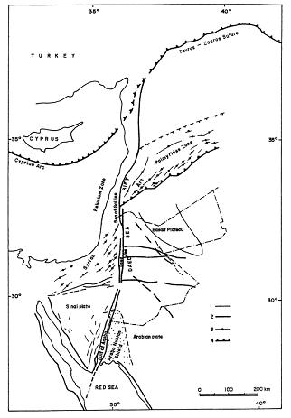
Generalized tectonic setting of the Middle East, showing the Arabian plate, Sinai sub-plate, the Dead Sea transform (including Gulf of Aqaba, Dead Sea, and Sea of Galilee) and Palmyrides zone. (1) Faults; (2) main faults; (3) fold axes; and (4) main thrust fronts (modified after Ben-Avraham and Grasso, 1991; Bender, 1975)
More fault segments are shown buried on seismic reflection profiles, which do not offset or perturb the upper sedimentary section (e.g., ten-Brink and Ben-Avraham, 1989; Frieslander et al., 1995; Al-Zoubi and ten-Brink, 2001; Al-Zoubi and ten-Brink, 2002), indicating that they are no longer active. The crustal structure of Jordan has been a matter of debate. Most of these studies in this context have focused on the Red Sea, the Dead Sea and the western side of the transform (Ben-Avraham et al., 1996; Ginzburg and Ben-Avraham, 1997; Ginzburg and Folkman, 1981; Ginzburg et al., 1981; ten Brink et al., 1990, 1993). The deep crust and upper mantle in the eastern side of the transform have been investigated using earthquake and seismic refraction methods with limited scope (El-Isa, 1990; El-Isa et al., 1987; Kovach et al., 1990). The characteristics of the crustal structure of Jordan was investigated by Al-Zoubi and Ben Avraham (2002), using the potential field methods over a broad region. The oldest rocks known in the area, dated as Pre-Cambrian (more than 450 million years; Bender, 1974), outcropping in its southwestern area (Fig. 4).
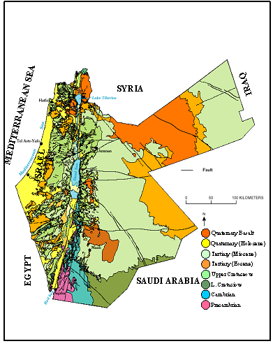
The Northwestern Arabian block (Jordan) has been generally regarded as structurally featureless, except for a few well-acknowledged faults. Jordan Geological Map (modified after Bender, 1968) displayed only few sets of faults (Fig. 4) trending N-S and NW–SE and E-W striking short faults in the central part of Jordan. The significance of these faults is due to the fact that they control the mineral deposits, oil and gas within several sedimentary basins and groundwater flows. Similarly, there are other natural resources (mineral deposits, hydrocarbon and groundwater flow) scattered at various geologic sites associated with fluid conducting faults.
Since the Pre-Cambrian times, the granitic shield, which is known as Aqaba Granite Complex (AGC), continued to be main sediments source to the surrounding basins. The tectonic history of Jordan may be divided into three distinct phases: (1) the Gondwana; (2) Syrian Arc, and (3) Rift phases (Dewey et al., 1973).
The Gondwana phase
During the Gondwana Phase (Cambrian–Early Cretaceous), Jordan occupied a position near the northern margin of the Gondwana paleocontinent. Tectonically, the area was relatively stable and sedimentation was dominantly continental, with minor but widespread marine incursions. Lower Paleozoic rocks of Cambrian, Ordovician and Silurian age outcrop in southern part of Jordan. On the western side of the Dead Sea–Jordan Rift Valley, the presence of the upper Carboniferous and Permian rocks of the pre-rift sequence, are continental clastic to shallow marine carbonate.
The Syrian arc phase
The sedimentation pattern of Gondwana phase continued into the Triassic and Early Jurassic but became increasingly more marine. The shoreline position from Triassic to Late Cretaceous remained roughly stationary across central Jordan with the sea opening in the northwest.
During the Late Cretaceous, subduction of the Neo-Tethyan oceanic lithosphere was initiated to the north. The resulting compression along the southern margin of the Neo-Tethys is indicated by locally obducted ophiolites and folding in the Syrian Arc trend. The Syrian Arc defines a sigmodial trend extending from the northern Sinai northwards into Syria (Fig. 3), following the trend of the Late Cretaceous continental margin. Extension within the Arabian plate during the Late Cretaceous (Bender, 1974; Lovelock, 1984) caused a series of northwest-trending basins such as the Al-Azraq and Wadi Sirhan Basins (Fig. 2).
Later strike-slip faulting in the Neogene modified the overall configuration and structural style of the Al-Azraq and Wadi Sirhan Basins and offset the fold geometry of the Syrian Arc trend. Transgressions from the northwest to the southeast occurred several times during the Mesozoic. In the western part of Jordan, volcanic activity is represented by dykes and sills of mafic to felsic composition, was active between Middle Jurassic and Early Cretaceous. These intrusives are found in the Wadi Araba region cutting Mesozoic sedimentary rocks (Bender, 1974) with a prominent magnetic expression. During the Late Oligocene–Early Miocene, left lateral movement along the Dead Sea–Jordan Rift Valley was initiated. Coarse lenticular unsorted conglomerates begin to appear in the section overlying Late Cretaceous or Early Tertiary units in the eastern Wadi Araba Area showing an unconformable relationship locally. The field evidence from several localities indicates uplift and probably tectonic activity (Bender, 1974). The regional fault system consists of a series of three major west-stepping, en-echelon faults, with well defined pull-apart basins formed at each of the major offshoots (the Gulf of Aqaba, Dead Sea basin and Sea of Galilee basin: Figs. 2 and 3).
The rift phase
Total strike-slip displacement along the Dead Sea Rift system is estimated at 105 km (Freund et al., 1970). Matching the structural and sedimentary features offset across the fault zone, Quennell (1951) estimated that separation took place at two successive stages during the Miocene and the Late Pleistocene.
Garfunkel (1981) and Freund et al. (1970) have reached a similar conclusion by measuring contemporaneous motion in the adjoining Red Sea and they suggested that the second rift stage took place at 4–5 Ma ago. As the Dead Sea rift opened, more than 3.5 km of evaporites were deposited, probably during the Late Miocene to Early Pleistocene (Bender, 1974). The amount of basin fill within the Dead Sea basin exceeded than 10 km (Ginzburg and Ben-Avraham, 1997).