Introduction
The Bohai Bay Basin is the largest of the Mesozoic and Cenozoic basins belonging to the North China craton (NC), a unique craton amongst the Earth’s other stable cratons in that it has been tectonically active since the Mesozoic (~220 Ma) (Gao et al., 2002). The destruction of the North China craton has aroused much interest within the international geological community in recent times.
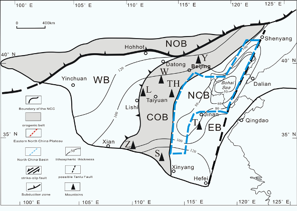
The North China craton, China’s oldest continental fragment, is composed of three main Archean elements: the Eastern Block, the Western Block, and the intervening Central Orogenic Belt (Zhao et al., 2000; Kusky et al., 2001; Li et al., 2002; Zhai et al., 2005) (Figure 1). The tectonic histories of the Eastern and Western Blocks diverge from the Mesozoic and Cenozoic. In the Mesozoic, the western NC developed a shallow marine basin and passive continental margin, while the eastern NC was uplifted to form the "Eastern North China Plateau" (Ren, 1999; Deng et al., 2000; Dong et al., 2000; Zhang et al., 2001a, 2001b, 2001c) and, in the Cenozoic, the western NC was uplifted to form a loess plateau while the Eastern North China Plateau collapsed to develop an extensional basin-mountains system (Zheng et al., 1988; Yan et al., 1996; Hou et al., 1998, 2001, 2003; Zhang et al., 2001a, 2001b, 2001c).
Figure 1. The Pre-Cambrian tectonic divisions and lithospheric thickness contours of the North China Craton

WB-West Block; COB-Central Orogenic Belt; EB-East Block; NOB-North Orogenic Belt; NCB-North China Basin Y-Mt.Yanshan; W-Mt.Wutai; TH-Mt.Taihang; L-Mt.Luliang; Z-Mt.Zhongtiao; S-Mt.Songshan; T-Mt.Taishan
(sources: Lin et al., 2005; Hou et al., 2006a,b)
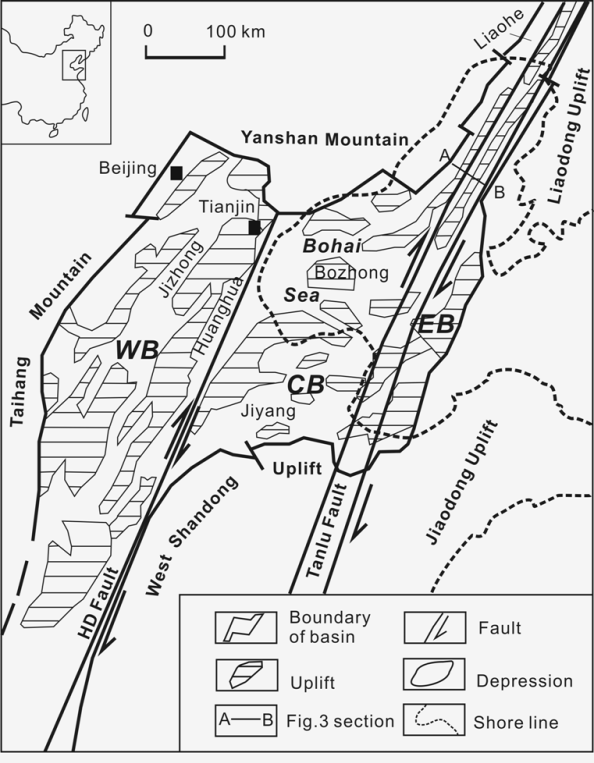
The Bohai Bay Basin is located within the eastern NC (Figure 2) and represents one basin of the basins-mountains system, which also includes the North China Plain and Bohai Sea. The eastern parts of the NC host the components of the NC that were tectonically reworked in the Mesozoic-Cenozoic (Hong, 1989; Tian et al., 1992; Liu, 1997; Hou et al., 2003). The Bohai Bay Basin trends north-south, has a length of c. 1000 km and a total area of c. 200,000 km2. Five mountains surround it, the Yanshan, Taihang, Taishan, Jiaodong and Liaodong (Ye et al., 1985). The Bohai Bay Basin developed evidence for extension of the eastern NC in the Cenozoic, following destruction of the craton. Its exact timing and tectonic evolution of the eastern NC during the Mesozoic, prior to its destruction, are issues of importance if the tectonic development of the NC is to be better understood.
Figure 2. Cenozoic tectonic divisions of the North China Basin
HD Fault-Huanghua-Dongming strike-slip fault; WB-Western Basin; CB-Central Basin; EB-Eastern Basin
(modified after Hu et al., 2001; Lu et al., 1997)
The Cenozoic evolution of the Bohai Bay Basin has been well treated by a number of existing articles (Yin and Nie, 1996; Ren, 1999; Hsiao et al., 2004). The majority of these works have focused on issues including the gravity field, highly conductive asthenosphere, thermal history, onshore structures and Cenozoic tectonism (Ye et al., 1985; Wang et al., 1985; Liu, 1987; Allen et al., 1997; Wang and Wang, 1988; Hong, 1989; Zhao and Windley, 1990; Hu et al., 2001; He and Wang, 2003; Zhao and Zheng, 2005). Inconsistencies in the conclusions of previous studies suggest that the Bohai Bay Basin experienced a complex development. The Cenozoic dynamics of the entire basin remains controversial due to lack of comprehensive research of the offshore (Bohai Sea) portion of the Bohai Bay Basin. The timing of the onset and the evolution of the destruction of the NC has been obscured by the lack of a complete understanding of the Mesozoic development of the Bohai Bay Basin.