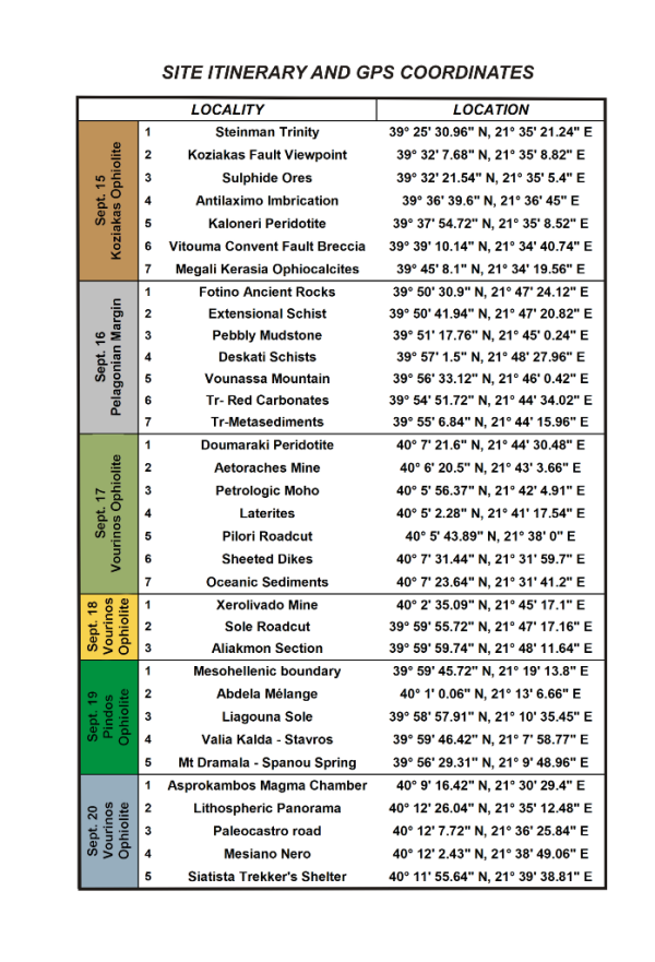
Framework Geology for the Symposium Fieldtrip
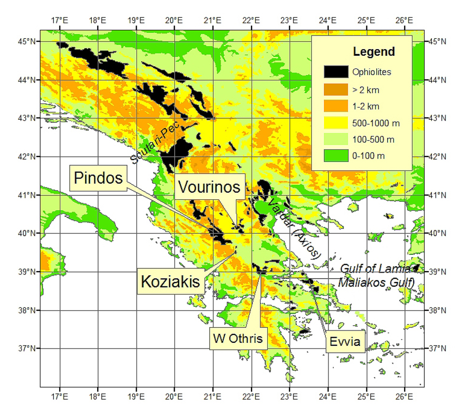
The geology of Greece is complex. For the purposes of this field guide only the geology of central and northern mainland Greece will be described, with particular emphasis on the ophiolites (Figure 1).
Figure 1. Distribution of ophiolitic rocks in the Hellenides.
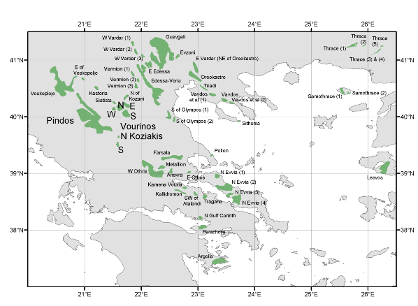
Distribution of ophiolitic rocks in the Hellenides. The complexes to be visited are in larger font: Pindos, Vourinos and Koziakis.
Ophiolite distribution in Greece and former Yugoslavia: The ophiolite distribution in Greece shows no obvious pattern (Figure 1), but when the ophiolites of former Yugoslavia are added a clearer pattern emerges (Figure 2).
Tectonically, the Greek ophiolites are part of the Hellenides, the orogenic belt that terminates in Albania along the Scutari (Skudar)-Pec line. NW of the Hellenides lie the Dinarides, which start in Albania and continue throughout most of former Yugoslavia.
From the most northerly outcrop in former Yugoslavia at about (45ºN, 17ºE) the Hellenic-Dinaric ophiolites trend SE and then split into two outcrop belts at about (44ºN, 19ºE) that gradually separate from one another until at (42.5ºN, 20.5ºE) their closest main outcrops are roughly 40 km apart.
Eastern ophiolite belt: The major eastern belt continues SE as a series of discontinuous outcrops that widen in extent to about 90 km at the Greek border. These ophiolites lie in the Vardar zone (named after the Vardar River in former Yugoslavia) and its Greek continuation, the Axios zone, referred to here as the eastern Hellenic ophiolite belt.
Western ophiolite belt: The western ophiolite belt has a major offset at about (42.5ºN, 20.5ºE) along the Scutari (Skadar)-Pec line, interpreted as a through-going transform fault. This fault has been suggested to cut the platform carbonates to the W of the ophiolites, but field evidence suggests that this is not the case. More likely it is a short (“leaky”) transform segment connecting two offset oceanic domains.
S of the Scutari (Skadar)-Pec line, the western ophiolitic belt, including all the ophiolites to be visited on our field trip, continues as a linear belt of discontinuous outcrops about 400 km long, extending S at least to the Othris Mountains at about 39ºN and possibly including
Evvian ophiolitic fragments and even those of the Peloponese. However, along Othris, outcrops appear to be offset across the Sperchios River and the Gulf of Lamia (Maliakos Gulf) in the opposite sense to that on the Scutari-Pec line. The offset is immediately S of the only large plagioclase lherzolite massifs known in the Hellenic ophiolites and it may represent a second transform zone.
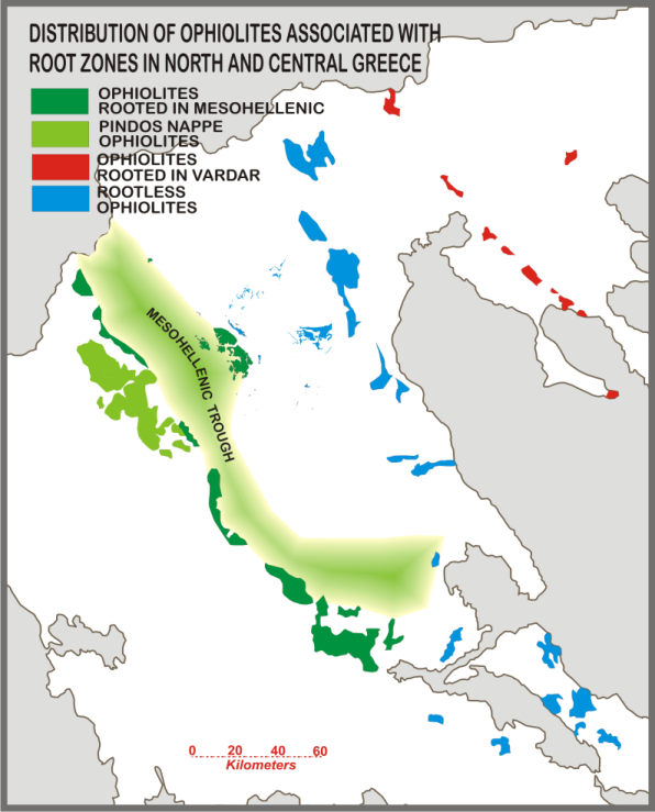
The Mesohellenic trough and its relationship to the western Hellenic ophiolites: The western ophiolites are allochthonous, forming sub-horizontal sheets locally exceeding 11 km in thickness (Vourinos). The sheets are pervasively imbricated, with duplexes reflecting their emplacement history. The main outcrops in the western ophiolite belt in Greece are the Pindos (2500 km2), Vourinos (450 km2), Othris (800 km2) and Evvia (=Euboea) (400 km2) (Figure 1). Outcrop discontinuity along the western margin is mostly due to the superposition of the sediments of the Cenozoic Mesohellenic trough (MHT, Figures 4 & 5). These Mesohellenic sediments cover presumed connections between the Pindos, Koziakas ophiolite, and western Othris ophiolite and the continuation between the Pindos and Vourinos ophiolites. Geochemical variability between Pindos and Vourinos has suggested that they represent distinct ophiolites that were never joined together. However, reports of deep drilling through the Mesohellenic sediments confirmed they have an ophiolitic floor.
The MHT itself is an Eocene-Miocene sediment-filled tectonic basin extending >350 km from N Albania across Greece into Thessaly. It is ~20-30km wide, with sediments as thick as ~5 km near Grevena. Generally agreed to be constrictional, the basin originated as part of the late Apulian-Pelagonian collision, and the “fossil” African-European plate boundary has been corellated beneath its western margin. Vourinos extends to the west into the MHT; parts of the Pindos (Dotsiko strip ophiolite, Milia-Kranea strip) extend east steeply into the MHT, much like the position of Koziakas against the Pindos zone. The majority of the part of the Pindos outcrop seems to be represented by a distinct nappe broken off from the Mesohellenic slab with less clear connection to the sub-Mesohellenic ophiolites.
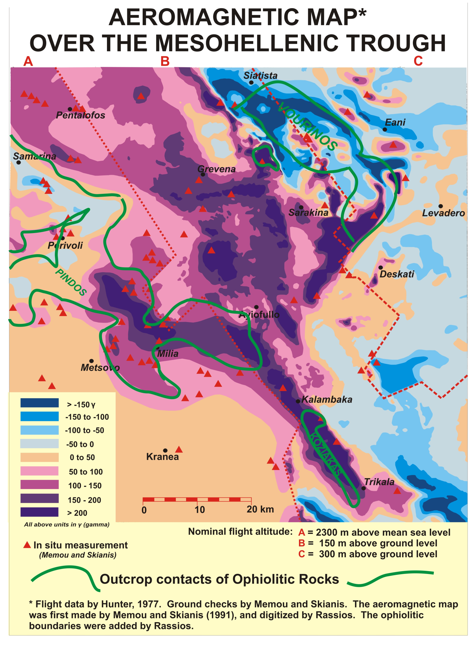
A magnetic anomaly map (Figure 3) shows that the Pindos, Vourinos, Koziakis and Othris are parts of the same ophiolite body, reaching a 25 km thickness beneath the MHT. Though complexly deformed internally, all the western ophiolites are most probably part of a huge ophiolite body that may have originally had dimensions of 400 km × 70 km, (assuming shortening in the MHT) referred to as the Mesohellenic Ophiolite Slab or Pindos Basin ophiolite.
Figure 3. Magnetic anomaly map of western central Greece

Model (after Wright, 1986) of deformation of ophiolitic slab moving off-ridgecrest in constrictive ductile to brittle fields.
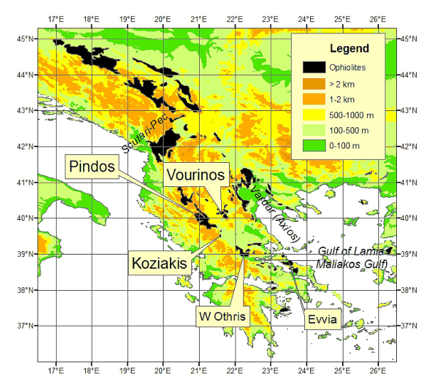
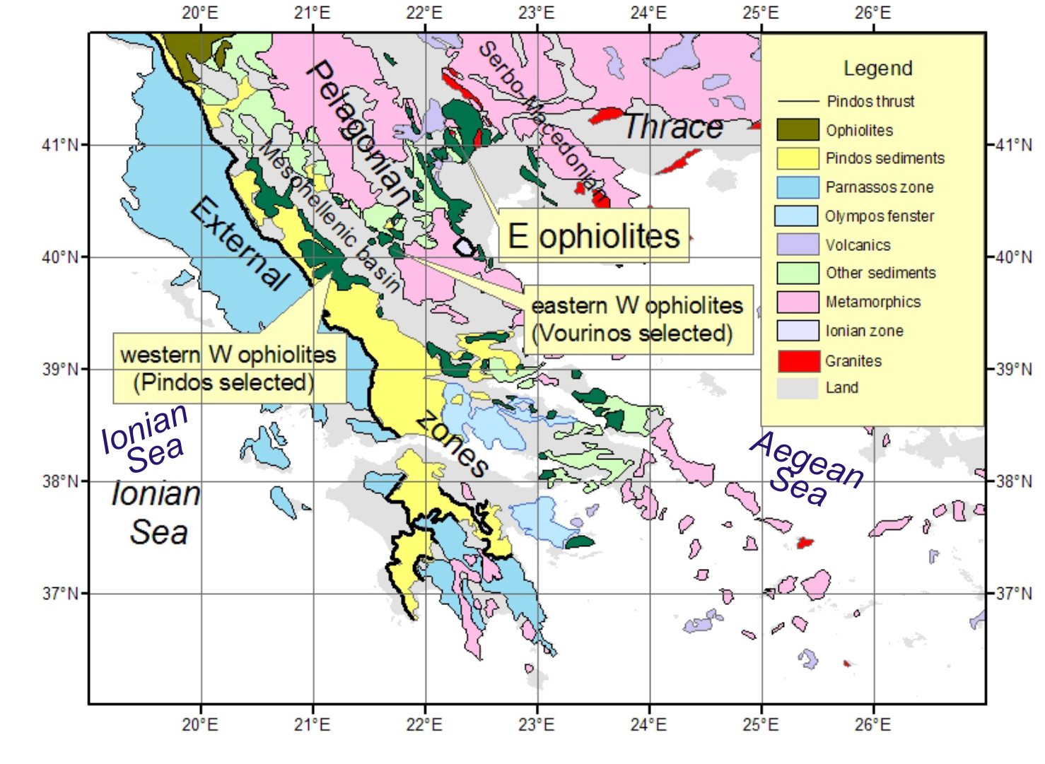
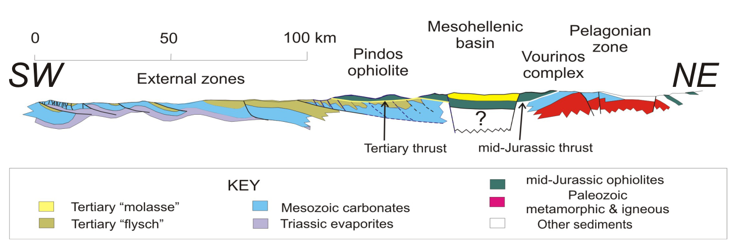
Geologic Section across the Fieldtrip Area: A traverse from the Ionian Sea to Thrace crosses five tectonic units.
Figure 4. Outline geological map

Outline geological map showing the external zones; the western Hellenic ophiolite belt; the Pelagonian zone; the eastern Hellenic ophiolite belt; and the Serbo-Macedonia zone.
The westernmost unit comprises the so-called external zones of the Hellenides; their eastern boundary is their contact with the western Hellenic ophiolite belt. The eastern boundary of this ophiolitic belt lies along the western margin of the Pelagonian zone. The Pelagonian zone extends to the western limit of the eastern Hellenic ophiolite belt. The fifth tectonic unit, the Serbo-Macedonian zone, crops out east of this belt. Thus from SW to NE the five units that are traversed are the external zones; the western Hellenic ophiolite belt (to be visited on this field trip); the Pelagonian zone, the eastern Hellenic ophiolite belt and the Serbo-Macedonian zone.
Figure 5. Schematic section across the eastern Hellenic ophiolites and the Mesohellenic trough.
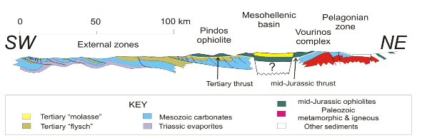
.Schematic section across the eastern Hellenic ophiolites and the Mesohellenic trough.
Mesozoic rocks of the external zones make up a series of carbonate platforms and pelagic troughs above concealed basement: the basement formation of the Pindos Zone is not exposed. However, continuation of these units southward into the Peloponnese reveals a metamorphosed continental basement. The Pindos zone, the innermost external zone, is a former pelagic basin, deformed into a stack of imbricate thrusts in the Tertiary, and tectonically emplaced above other units of the external zones. In turn, the Pindos zone is itself overthrust by a detachment of the western Hellenic ophiolites in the Eocene.
The basement of the Pelagonian and Serbo-Macedonian zones is made of metamorphic and igneous rocks that include Precambrian and early Paleozoic terrains welded during Hercynian collision. All the Hellenic ophiolites, western and eastern belts, are regarded as slices of fossil oceanic lithosphere (here including back-arc basins) emplaced at Jurassic convergent plate margins consisting of adjacent continental margins or island arcs. Dating shows their crystallization to be Middle Jurassic in age (see below).
General lithology of the western ophiolites: Harzburgite with associated dunite is the dominant ultramafic component of all the western Hellenic ophiolites. Lherzolite crops out within the Pindos and Koziakas, and dominates some massifs of W Othris. Dunite bodies within peridotite are shape-defined by overprinting ductile deformation, resulting in tabular, podiform or irregularly-shaped bodies ranging in their largest dimension from a meter to tens of kilometers. Folding is pervasive in mantle peridotite, and ranges in wavelength from a few centimeters (as observed within chromite deposits) to more than several kilometers. No km-scale recumbent folds (i.e. nappes) have been located.
Vourinos is the least disrupted massif and includes a “complete” ophiolite section from an ultramafic tectonite base, crossing an intact petrologic Moho, through a cumulate ultramafic sequence into gabbro, sheeted dykes, minor pillow lavas and oceanic sediments. The Pindos and Othris complexes lack continuous section, though several thrust units contain overlapping stratigraphic elements and include all the structural and petrological elements regarded as the hallmark of an ophiolite. In each of the thrust units of the Pindos and Othris, an essentially up-section orientation is retained, while a “reverse” pseudo-stratigraphic order is observed among the thrust sheets: the higher thrust sheets are mantle section, lower sheets crustal, with pillow lavas and sediments in the bottom-most sheets. Koziakas tectonically resembles Othris, but has been extensively sheared and imbricated against the westernmost Pindos Zone formations. Though it lacks extensive cumulates and sheeted dikes, their presence can be inferred from minor tectonic remnants, well-developed hydrothermal systems, and abundant lavas.
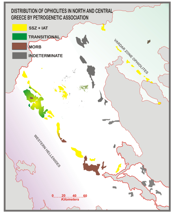
Geochemical and structural variations within the Mesohellenic Ophiolite slab: Data collected during exploration for chromite and copper ore in the western Hellenides indicate pronounced lateral changes in ophiolite composition: from a supra-subduction zone setting in the Vourinos Complex, a harzburgite-lherzolite unit in the Pindos including MORB to IAT and boninite affinities, that links up, via the Koziakas ophiolite, with the Othris ophiolite, dominated by plagioclase lherzolite-lherzolite-harzburgite mantle rocks and MORB-like lavas.
Chromite occurs within dunite throughout the slab, but its abundance as an economic mineral varies. In Othris, chromite shows are very rare, although several >million ton (mt) deposits were mined; in the Pindos, chromite shows are common, but all are sub-economic; in Vourinos over 800 chromite occurrences were mapped including ~8 mt of ore in six major districts.
Petrogenetic variations are also reflected in the fabric: Othris and Koziakas peridotites are intensely mylonitized; Pindos peridotites are less mylonitized, with Vourinos being the least mylonitized.
Ophiolite contacts: The nature and age of the thrust surface beneath the ophiolite slab also varies. In the east (Vourinos), the ophiolite lies directly on the Pelagonian carbonate platform and the contact zone is of mid-Jurassic age. It was hot and ductile at the initial time of formation. In the west (Pindos and Othris), a detachment of the slab was thrust over Tertiary “flysch” in cold and brittle constrictional conditions. However, the original hot, Jurassic Pindos sole is preserved in situ between mantle peridotite and a Jurassic accretionary mélange (Avdella mélange). Sole dates from the Pindos, Othris, and Koziakas are indistinguishable from those at the base of the Vourinos complex (Figure 5). These dates have not been reset by Tertiary thrusting. Koziakas, again post original Jurassic obduction, appears tectonically emplaced, again in the Tertiary, directly against Pindos Zone carbonates, probably much like deeper portions of the Mesohellenic slab are deformed against the western “wall” of the MHT.
Tertiary (Eocene) overthrusting of the western margin of the Mesohellenic slab was directed towards the SW, though later Tertiary constriction movements top to the NE.
The original Jurassic emplacement direction of the Mesohellenic Slab is more controversial. In Vourinos, the only strongly developed brittle shear set is geometrically similar to the oldest shear set of the Pindos and Othris. Ductile-brittle shears display characteristics typical of both mylonitic and brittle fabrics and are assumed to have been initiated in the ductile field when the ophiolite was hot. In Vourinos the transition from these and other ductile structures, such as mylonite zones and sheath folds, into NE-verging brittle structures is gradual, and all interpreted as drift to early emplacement features. This implies that parts of the ophiolite were still in the ductile field when emplacement to the NE was initiated and that these structures record the main phase of early deformation (Figure 6).
Figure 6. Deformation model
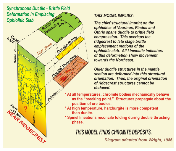
Cartoon showing distribution (after Wright, 1986) of deformation in lithospheric-ophiolitic slab from position near ridgecrest and passing into constrictive deformation. At any time, ductile to brittle deformation is concurrent at different depths in slab, with brittle field at greater depths away from ridgecrest.
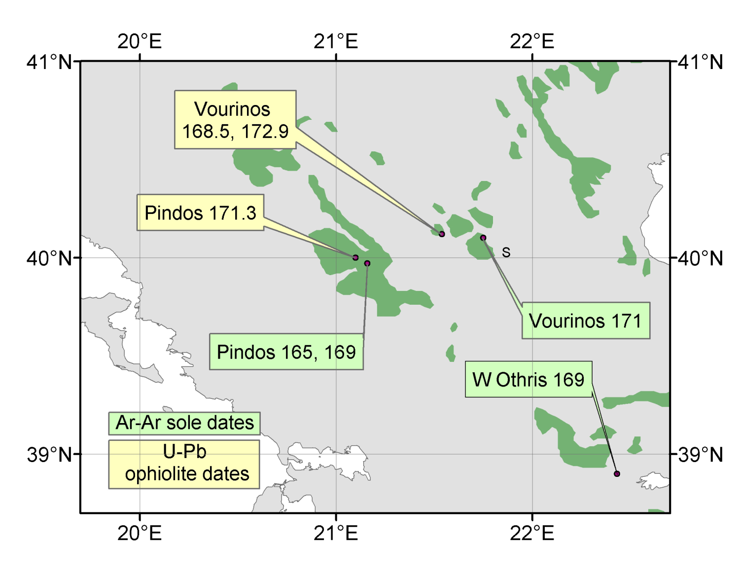
Ophiolite dates: Dating of the Hellenic ophiolites is still in its infancy. Figure 7 shows U-Pb SHRIMP dates from the Vourinos and Pindos ophiolites (average 170.9 Ma), and Ar-Ar dates from amphiboles in the metamorphic soles of the Pindos, Vourinos and W Othris ophiolites (average 168.5 Ma). The 2.4 m.y. time-difference between ophiolite crystallization and sole formation is close to the time-difference between the crystallization of the well-dated Samail ophiolite and its sole in Oman.
Figure 7. Ar-Ar dates in Ma on amphiboles in metamorphic soles and U-Pb SHRIMP dates on zircons in ophiolites.
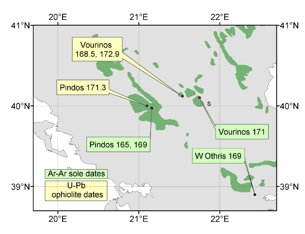
Ar-Ar dates in Ma on amphiboles in metamorphic soles and U-Pb SHRIMP dates on zircons in ophiolites.
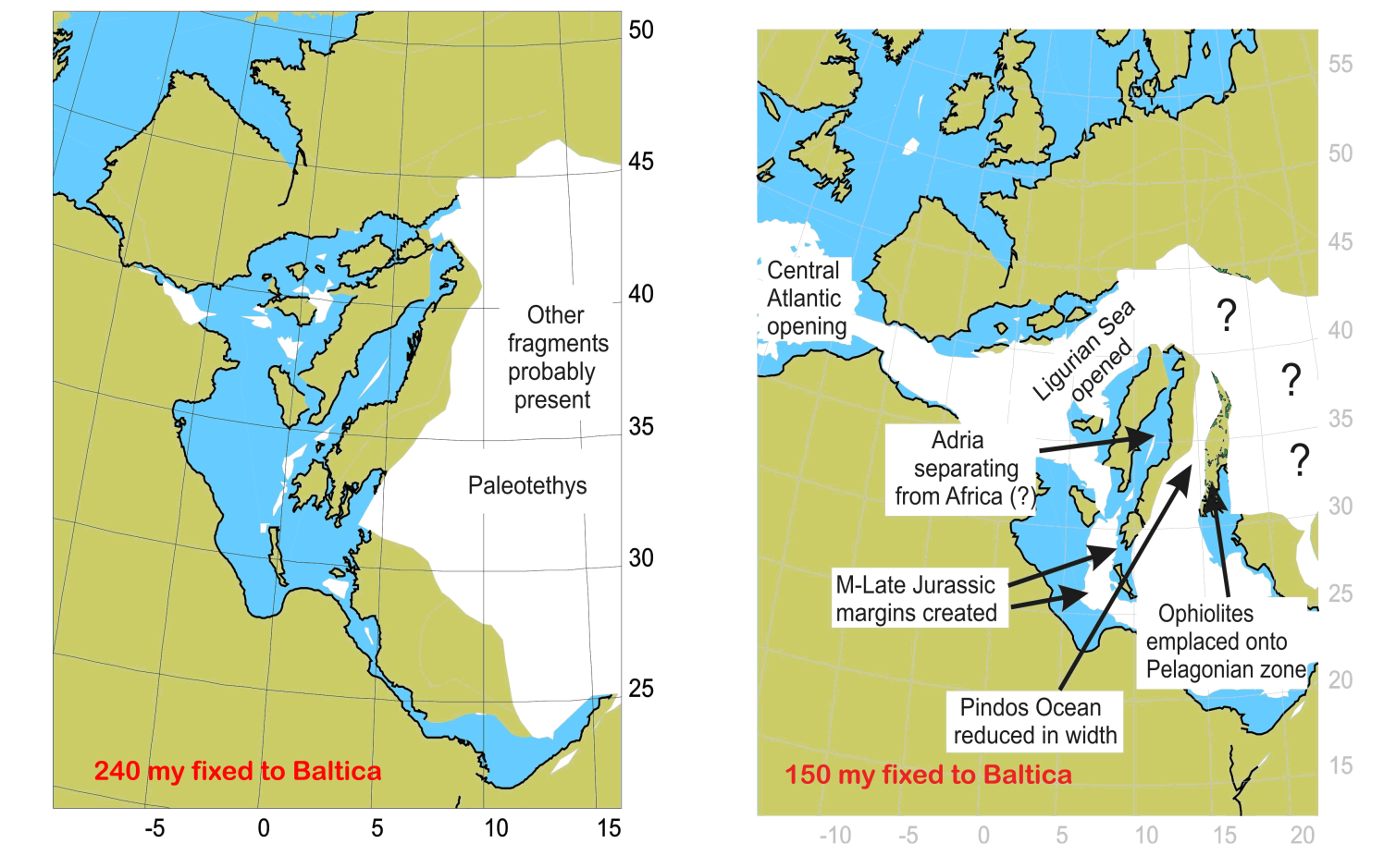
Possible paleocontinental evolution: What is now Greece coalesced tectonically from the collision of one or more Hercynian continental fragments (Pelagonian zone, Serbo-Macedonian zone) with the external zones, facilitating the emplacement of parts of intervening Jurassic oceanic regions that now are represented in the western and eastern Hellenic ophiolites (Figure 8). Exhumation of the older continental blocks, possibly as early as late Jurassic and lasting to mid-Cretaceous, certainly affected the ophiolitic belts at their margins, though this has yet to be detailed. Post-emplacement Pelagonain exhumation, and continuing deformation (largely Alpine), further constricted the Hellenides.
Figure 8. Cartoons showing speculative reconstructions at 240 and 150 Ma.
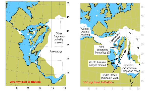
In the first (240 Ma = early middle Triassic), present-day Greece is broken along the zone of the eastern ophiolite belt and attached to eastern Italy and N Africa. In the second (150 Ma = late Jurassic) the Pelagonian zone separated from western Greece, joined to Italy to form Adria, separated from N Africa. The small ocean between the Pelagonian zone and eastern Greece (Pindos Basin) has already closed by this time, and the Pindos Basin ophiolites emplaced eastward, onto the Pelagonian zone. No attempt has been made to show the history of the eastern ophiolite belt.
Some problems: It should be clear from the caption to Figure 8 that the configuration prior to collision is not known and the details of the collisional process are disputed. In particular, the relationship of the western Hellenic ophiolites to the eastern Hellenic ophiolites is unclear. The presence of sparsely scattered, probably ophiolitic-derived serpentinite masses, lavas of unclear association, and Jurassic ocean sediments throughout the area separating the two ophiolite belts argues strongly that they were once a continuous nappe. But was this nappe an extension of the Pindos basin ophiolites, or the Vardar Zone ophiolites?
Several interpretations exist with respect to the original relation between the two ophiolite belts (Figure 9):
The western and eastern ophiolites were always separate from each other. The western ophiolites originated somewhere in the original Pindos basin, and eastern ophiolites in the original Vardar basin.
The western ophiolites were originally joined to the eastern ophiolites. The “root zone” for both belts was originally within the Vardar (Axios) zone, but their original continuity has been destroyed by Pelagonian exhumation and erosion. Conversely, recent discusion posits whether the origin of nearly all the ophiolites was from the Pindos Basin, and whether some eastern bodies are indeed ophiolites or large masses within mélange
The western and eastern ophiolites were originally continuous, but have been separated by strike-slip (transcurrent) faulting.
Figure 9. Possible Relations between the Pindos Basin and Vardar Zone ophiolite belts with potential root zones.
There are many other basic questions to be considered, some apparently applicable to the Mesohellenic slab alone, others overlapping with basic problems inherent to using ophiolites as analogues for oceanic lithosphere.
Is the geochemical variation among the Pindos basin ophiolites a primary oceanic feature, or is it a construct of emplacement deformation? Do the ductile features within the slab describe the motions and mechanisms of drift and emplacement? Does the Mesohellenic trough fortuitously divide the Vourinos from the Pindos ophiolites, or does it follow an even more deep-seated structural plate tectonic divide? To what degree are the petrogenetic and structural processes demonstrated in these ophiolites unique, or do they describe processes common to all ophiolitic rocks?
Our field symposium hopes to present field data that may aid in resolution of these questions as well as to propose, through discussion, entirely new solutions to these puzzling ophiolites.