In the past Samos was connected to Anatolia. The narrow strait that is now separating Samos from western Anatolia is less than 1.5 km wide and less than 30 m deep. The coasts in the wider region are characterized by submerged ancient ruins (Flemming 1978), indicating that, at least in the Late Holocene, its coastal morphology is controlled by marine transgression.
Samos is made up by three metamorphic massifs coinciding with topographic highs: the Kerketas Massif in the west, the Ampelos Massif in the central part of the island and the morphologically much less expressed Zoodochos Massif in the east (Fig. 2). These three topographic highs are separated by Neogene sedimentary basins coinciding with topographic lows: the Mytilini basin in the east, the Pyrgos basin in the central part of the island and the Karlovasi basin in the west (Fig. 2). The northwestern part of the island (the northwestern Kerketas Massif) is mountainous and characterized by steep cliffs and highly incised streams with fluvial terraces. The topographic gradient is very pronounced and the coast lines are commonly fault controlled. The topographic gradient decreases markedly to the E and SE. At the SE coast of Samos there is archaeological evidence of coastal subsidence. These relationships strongly support the interpretation that Samos Island is a tilted horst block.
A more than 1000 m deep marine basin occurs on the northwestern side of Samos (Fig. 9). The bathymetric gradient and the spatial relationship between the deep basin and the pronounced topographic gradient on-land suggest that a major normal fault controls the NW and W coast of the island (Mascle and Martin 1990). The prominent topographic gradient, deeply incised V-shaped valleys with rapids, waterfalls and active pools in the river beds testify to a young, tectonically-controlled relief in the NW. All along the other coasts, the bathymetric gradient is much less pronounced and water depths do not exceed 50-200 m (Fig. 9).
Figure 9. Uplifted shorelines
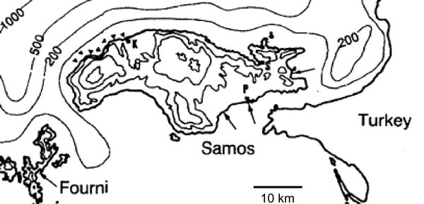
Uplifted shorelines of NW Samos (marked by solid triangles), submerged beaches of SE Samos (marked by arrows) and simplified bathymetry.
Relicts of 3 fossil shorelines and uplifted marine platforms can be found in the northwestern part of Samos (Fig. 9) (they are referred to from top to bottom as the upper notch, the upper platform and lower platform; Stiros et al. 2000). Stiros et al. (2000) interpreted the more or less linear array of uplifted shorelines as being related to Holocene fault activity (see field trip stops #2.1-2.4 below). The fossil shorelines can be traced along a distance of over 10 km along the NW coast of Samos between the Karlovasi harbour and Katavasi Cape and are on average 0.6±0.2, 1.1±0.2 and 2.3±0.2 m above sea level. Stiros et al. (2000) showed that the uplifted shorelines are related to earthquakes, which occurred at approximately 500 yr BP (or ~1500 AD), ~1500 yr BP (~500 AD) and 3600-3900 yr BP (1600-1900 BC). During the punctuated uplifts of the shorelines in a relatively short time interval between 2000 BC and 1500 AD no significant global or regional relative sea-level fall is reported (Pirazzoli 1991), lending further support into the interpretation that the uplift of the shorelines is tectonically controlled. As argued by Stiros et al. (2000), the preservation of fossil isolated species of the infra-littoral zone (Vermetus triqueteur, Serpulorbis) on raised shorelines suggests that these species crossed the mid-littoral zone, which is a zone of intense bioerosion, quickly. This indicates a rather rapid and sudden drop in sea level. If the rate of uplift had been slow (<~0.5 mm/yr), the fragile fossil remains would be altered and destroyed in a few years by mid-littoral bioerosion, which is generally considered to proceed at a rate of >1 mm/yr (Torunski 1979).
Stiros et al. (2000) plotted radiocarbon ages against the elevation of the samples from which the radiocarbon ages have been obtained (Fig. 10). The data combine to a loosely defined uplift rate of northwestern Samos of ~0.6 mm/yr.
Figure 10. Radiocarbon ages versus elevation
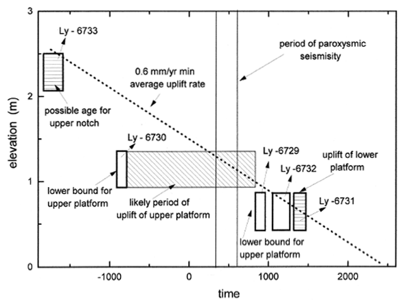
Radiocarbon ages versus elevation of samples from uplifted palaeo shorelines and marine platforms from Samos (from Stiros et al. 2000). Boxes indicate the radiocarbon age and elevation uncertainties of the samples analyzed. The horizontal box with thin lines and shading indicates the interval during which the upper platform was fossilized. The average uplift rate defined by the upper notch and the lower platform crosses the rectangle of the likely period of upper platform, at an interval coinciding with the period of paroxysmic seismicity in the Eastern Mediterranean (bounded by the two vertical lines).
A number of earthquakes of magnitude >6 have been reported from Samos in the last 200 years (at least 6 earthquakes during the 19th century, and another two earthquakes in the 20th century, i.e. 1904 M=6.8 and 1955 M=6.9), but the pre-19th century seismicity remains less well knwon. In the last 2000 years there is evidence of only 3 well defined earthquakes at ~200 BC, at 47 AD and at 1751 AD (Guidoboni et al. 1994; Stiros 1995; Papazachos and Papazachou 1997). There is also some evidence for an earthquake in 1476 AD that devastated Samos and was supposed to be one of the reasons which forced the Genovese, at this time the rulers of the island, and most of the inhabitants to abandon the island and emigrate to nearby Chios Island (Noos 1976).
Stiros et al. (2000) correlated the uplifted shorelines and marine platforms with the seismic events. They concluded that the lower platform, which they dated with radiocarbon at 1306-1467 AD correlates well with the possible earthquake at 1476 AD. The uplift of the middle palaeo shoreline (upper platform in Fig. 10) may correlate with the 47 AD event. However, Stiros et al. (2000) further argue that the graph in Figure 10 also allows the interpretation that the seismic uplift occurred at a later period, at ~500 AD. Interestingly, this period is broadly consistent with a period during which a series of 4th to 6th century coastal uplifts of unprecedented scale have been identified in the Eastern Mediterranean (Pirazzoli et al. 1996).