The dominant orientations of longitudinal desert dunes form a large, whorl-like pattern covering much of inland Australia, as illustrated in Figure 1. A more detailed map of the Strzelecki Desert dunefield east of Lake Frome is given in Figure 2.
Figure 1. Distribution of Australian dune fields.
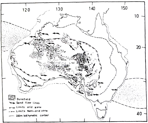
Map showing arid and semi-arid zones of Australia with distribution of major dune-fields. Sand flow lines constructed from trends of longitudinal quartz dunes and transverse crescentic lakeshore dunes (lunettes) provide resultant directions of winds during period of intensified dune building phase. Major dustfall areas over sea during this interval are designated by stippling in northwest and southeast of continent. Figure in Bowler (1976).
Figure 2. Lake Frome transverse ridges.
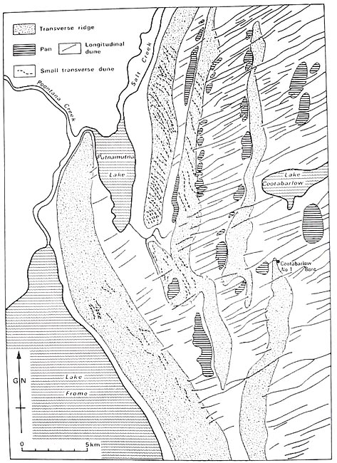
Northern Lake Frome showing transverse ridges on downwind side, with longitudinal dunes and aligned pans (Wasson, 1983).
Curiously, these dune orientations do not correspond to present day dominant wind directions, particularly in southern Australia. Attempts have been made in the past to explain this discrepancy between wind direction and dune orientation by invoking a regime in which dune formation occurs only at a particular time of year, during which winds blow from the appropriate direction. It is now thought that these dunes are largely fixed and subfossil (Bowler, 1976; Sprigg, 1979), and following this observation is of course the much simpler explanation that the dunes formed under a different climate regime to that existing today.
These dune orientations in fact correspond to the dominant wind directions that occurred during the Last Glacial Maximum (LGM) (Wasson, 1983), with the peak of dune formation occurring at 18-16 ka (Bowler, 1976). Wind speeds were generally increased and the mid-latitudinal atmospheric circulation patterns squeezed equatorward during the LGM, due to an increase in sea ice extent surrounding Antarctica and a steepening of the latitudinal temperature gradient.
While Australia has been only minimally glaciated during the global glacial cycles of the Pleistocene, it has nevertheless been strongly affected by these climate cycles. Through much of Australia this is expressed in fluctuations in aridity. These desert dune cycles have been described as "periglacial phenomena in a broad, global application of the term" (Sprigg, 1979).
Evidence for this subfossil state of the dunes includes radiocarbon dating of shell carbonate within clay dunes (Bowler, 1976), optically stimulated luminescence dating of quartz dunes (Lomax et al., 2003), and indirect evidence from pollen records preserved in lake sediments (for example at Lake Frome; Singh, 1981). By 13 ka the climatic stresses that were keeping longitudinal dunes in much of Australia actively forming relaxed, and the dunes became stabilised. Dunes and other desert landscape features that were present at this time remain well preserved today (Bowler, 1976).
Although there is only scant record of dune formation before the present glacial cycle (Lomax et al., 2003), it appears that the longitudinal desert dunes that cover much of inland Australia are generally stabilised, in part by vegetation cover and lessened wind speeds, during the interglacial periods, and that these same dunefields are reworked during glacial maxima, at which time they are actively forming and moving.