Excavations associated with mining at the Lady Buxton copper mine in the 1890's have exposed a thrust on the western side of the Paralana Hot Springs track (Figure 2). The footwall of the thrust comprises a well consolidated ferruginous conglomerate characterised by sub-angular to sub-rounded, poorly sorted polymictic clasts 610 cm in diametre. The clasts include Mesoproterozoic and Neoproterozoic material, as well as maghemite pebbles, in a matrix of sandy to gritty quartz cemented by ferruginous matter. The hangingwall comprises weathered Neoproterozoic marbles of the Wywyana Formation. The thrust is oriented 074 and dips at 19 toward the north-west. Linear grooves on the fault plain trend down dip, suggesting purely dip-slip movement. An estimate of displacement along the structure is problematic as the thickness of the footwall sequence is unknown.
Figure 2. Relationships at the Lady Buxton mine locality
Relationships at the Lady Buxton mine locality
The age of the thrust is poorly constrained as the footwall lithology is unique within the field area. The unit may be an equivalent of the Cretaceous Parabarana sandstone, but is most likely much younger. The presence of maghemite pebbles is important. None of the Mesozoic or Cainozoic rock units described by Callen and Tedford. (1976), note the presence of maghemite. Surficial lag of the modern outwash deposits of the area south of Lady Buxton mine contain abundant ferruginous material including sub-rounded maghemite, which rests on gritty brown sands composed of haematite and quartz. The conglomerates of the thrust footwall greatly resemble the contemporary outwash deposits of the area. It is conceivable that the Wywyana marbles have been thrust over a consolidated portion of the modern outwash deposits in the area, suggesting that the structure is in fact very youthful.
Whilst the maghemite pebbles of the thrust footwall suggest very recent movement along the fault, several lines of evidence suggest that the structure may be somewhat older. Firstly, the fault is not expressed in the geomorphology of the area, suggesting that the fault post-dates the most recent geomorphic processes. Moreover, the fault cannot be traced on ASTER imagery, nor aerial photography, and there is no expression of the structure within the hinterland or the Paralana High Plains.
In the hills on the southern side of Yudnamutana creek, where it exits the ranges, lithified conglomerates are capped by silcrete. The conglomerates and silcrete form a duricrust which dips gently toward the east, locally steepening to 50-55 on the western, rangeward, portion of the duricrust. In fault contact with these conglomerates is Mesoproterozoic granitic basement.
The conglomerates are comprised of sub-angular to sub-rounded clasts 615 cm in diametre, lying in a well lithified sandy matrix. On the basis of these characteristics, the unit is tentatively classified as belonging to the Early Cretaceous Parabarana Sandstone. Massive, grey nodular silcrete forms a cap on the western portion of the duricrust.
Although poorly outcropping, the fault separating the two units is defined by a zone approximately 1 metre wide of brecciated, kaolinitic material. The structure is oriented 042 and dips to the north-west at 30. Steepening of silcrete and conglomerate beds is understood to be as a result of fault propagation folding in the footwall of the structure, and indicates a reverse sense of movement.
If the conglomerates of the footwall are assumed to be Parabarana sandstone, andare correlated with the Early Tertiary Freeling Heights erosion surface, an estimate of post-Cretaceous displacement of these surfaces can be approximated. The Freeling Heights surface defined by Coats and Blissett (1971a), is at an elevation of approximately 1000 m, whilst the lithified conglomerates at this locality are at an elevation of approximately 200 m. Assuming that the two surfaces were deposited contemporaneously, a minimum of 800 m of displacement must have occurred along the fault described here since deposition in the Cretaceous. The observation that the silcrete cap is deformed ahead of the propagating fault has important implications regarding the timing of movement along the structure. Callen (1974) showed that silcrete development in the area occurred during the Oligocene. Given that the silcrete cap at this locality is deformed, movement along the structure must have occurred since the Oligocene.
Fluvial incision of the Paralana High Plains surface approximately 5.3 kilometres north-east along the range front from Hot Springs creek, has exposed a thrust within the Willawortina Formation alluvial fans (Fig. 3).
Figure 3. Fault displacement
Total of 80 cm displacement along fault through Willawortina alluvial fans. Displacement and reverse sense of movement established by the correlation of a sheared clast along thrust plane.
Deeply weathered sub-angular to sub-rounded boulders up to 1 metre in diametre lie in a sandy kaolinitic matrix. Characteristic red-brown mottling, as well as the deeply weathered nature of the sequence, distinguishes the sediments from the hill scree, and confirms their Willawortina Formation classification. The fault plain which cuts through the weathered Pliocene sequence strikes 026 and dips at 31 toward the west. Total displacement of 80 cm is indicated by a truncated clast across the fault plane, indicating a reverse sense of movement (Figure 3). 2 mm wide elongate grooveing lineations along the thrust plane are oriented down dip, suggesting a wholly reverse sense of movement.
A clue as to the timing of fault movement is provided by the fact that the thrust cuts deeply weathered Willawortina Formation sequence. Thrusting probably occurred after the large boulders, up to 1 m in diametre, had already been deeply weathered. The time scale for such deep weathering to occur cannot be accurately constrained, however, the deep weathering pre-dating fault movement, suggests that movement along the structure occurred a considerable amount of time after deposition of the alluvial fans in the Pliocene.
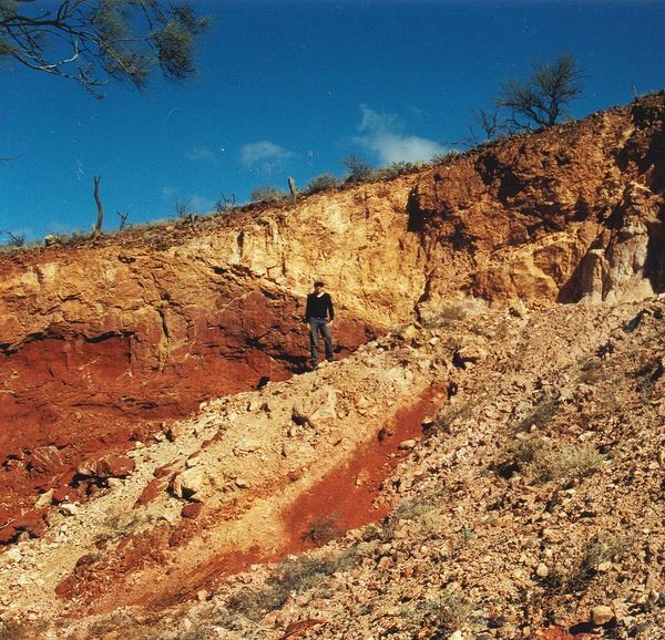
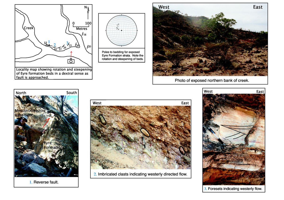
Approximately 6.2 kilometres north-east along the range front from Hot Springs creek, fluvial erosion has exposed a 200m long creek bank section within which a rich record of the regions young geological history is exposed (Fig. 4). The creek runs in a south-easterly direction as it exits the ranges, the exposed section being on its northern side.
Figure 4. Young tectonics at locality 4
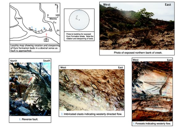
Manifestations of young tectonics at locality 4. Numbers in blue on the locality map give the location of the three photos at the bottom of the page. Camera icon on locality map shows position from which photo of the exposed northern creek bank was taken.
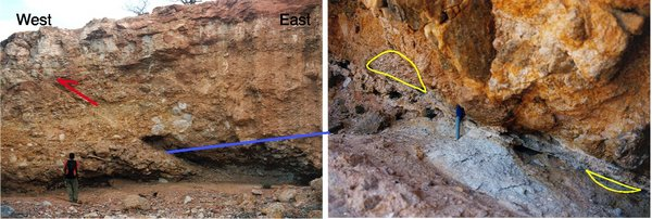
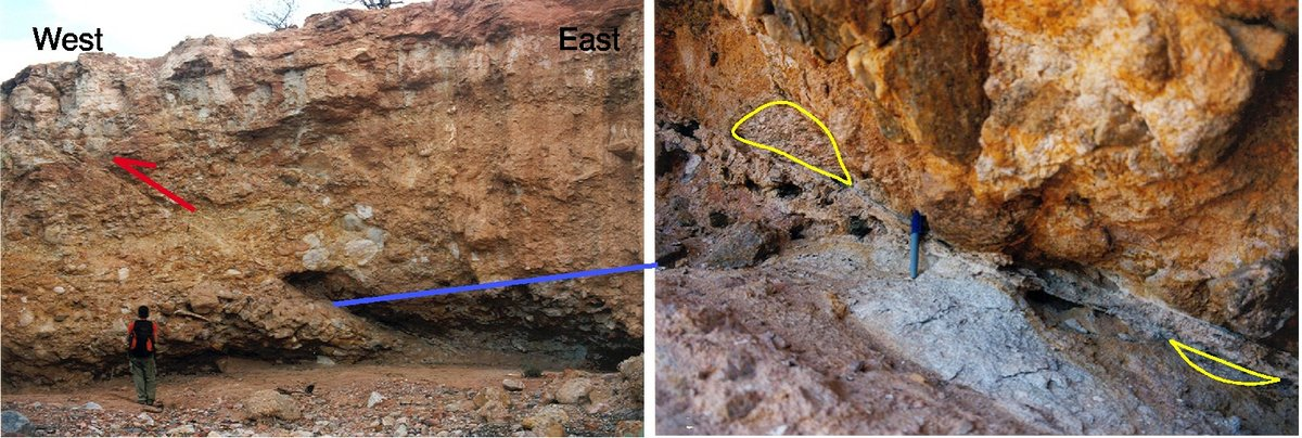
The rangeward, western section of the exposure hosts Mesoproterozoic granitic material. At the approximate position of the piedmont and Paralana High Plains intersection, a steep reverse fault juxtaposes the basement material against early Tertiary Eyre Formation (Figure 4). The structure is oriented oblique to the range front; striking 088 and dipping at 71 to the north. Fault groove lineations 5mm wide on the steep fault plane dip at 32 toward 272, suggesting a dextral, oblique slip component to the reverse movement.
The outcrop pattern, and orientation of the Eyre Formation beds surrounding the fault also suggests that a component of dextral oblique slip occurred during the faults most recent movement. Regional strike of the foreland sediments is approximately 010-025, however, the imbricated beds adjacent to the fault mimic the orientation of the structure, striking approximately east-west. As the structure is approached from the east, the strike of the Eyre Formation beds exposed on the creek bank gradually shifts from roughly north-south, to essentially east west. Dip of the beds also increases as the fault is approached. The fault does not have any expression in the geomorphology surrounding the outcrop, nor is able to be traced on ASTER imagery or aerial photography.
An uninterrupted 200 m section of Eyre Formation sediments extends downstream from the fault. Adjacent to the fault, the conglomerates are composed of matrix supported sub-rounded clasts of up to 10 cm in diametre, the matrix being kaolinite and sand. The Eyre Formation sequence fines downstream, passing through several fining upward sequences, with characteristic polished quartz pebbles at their bases. Sedimentary structures within the Eyre Formation sequence provide palaeocurrent information.
Imbrication of clasts in the conglomerates at the base of the sequence suggests that at the time of deposition, the fluvial systems that deposited these sediments flowed toward the west, the current position of the ranges (Figure 4). Throughout a number of the finer sandy cycles, numerous examples of westerly directed foresets are developed within the sequence (Figure 4).
Importantly, the imbricate fabric, and foresets developed within the Eyre Formation sequence have profound consequences relating to neotectonics in the region. For a westerly flow direction of the depositing streams to have occurred, the ranges could not have stood at their present elevation. The palaeocurrent indicators suggest that during the Eocene and Palaeocene there was no topography where the ranges stand today. The faulting and palaeocurrent data detailed above are robust evidence for post Eocene tectonic activity being responsible for the ranges standing at their current position and elevation.
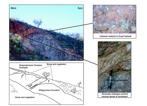
Approximately 8.6 kilometres north-east along the range front from Hot Springs creek, a thrust fault is exposed on the northern side of a small creek flowing away from the ranges. Subparallel to the range front, the mountainward block has been uplifted, relative to the Paralana High Plains (Figure 5). The footwall of the structure hosts very angular, poorly sorted white conglomeritic material of theWillawortina Formation. Clasts range in size from 1 to 20 cm in diametre and are entirely matrix supported, the matrix being composed of kaolinite and sand. Vertical mottles approximately 30 cm high are red brown haematite with an outer halo of yellow brown goethite. Overlying the Willawortina sediments is a 6 m long wedge of modern red hill scree cloaking the entire outcrop. The wedge is comprised of very poorly sorted and consolidated sub-angular quartzite clasts ranging in size from 3 cm to 1 m in diametre in a red coloured silty/sandy matrix.
The footwall terminates along the main thrust plane of the outcrop which is defined by a zone approximately 20 cm wide of flaky orange clayey material. Strike of the thrust plane is 012, with a dip of 25 to the west. Kinematic indicators along the plane confirm the reverse sense of movement (Figure 4). Five mm wide fault groove lineations on the fault plane trend down dip suggesting movement along the fault is dip-slip.
The hangingwall of the outcrop is complex, containing several reverse faults with varying orientations. Immediately overlying the main thrust plane is a band approximately 1.5 m thick of Eyre Formation composed of pale orange coloured, sub-rounded 1-10 centimetre clasts in a clayey matrix. Another reverse fault, oriented 000 and dipping 20 west, defines the top of this band of Eyre Formation. Above this fault, Neoproterozoic Paralana Quartzite sits in the hangingwall . Three more brecciated disruptions within the overlying Quartzite can be attributed to faulting.
Given the spectacular nature of the exposure, it is surprising that the structure is unable to be traced along the range front. Geomorphically, the fault is not expressed by any surface offsets or linear traces. Similarly, the structure is unidentifiable upon ASTER imagery or aerial photography.
Total displacement within the fault zone is difficult to quantify with any great accuracy. Callen and Tedford. (1976) show that the Willawortina Formation reaches a thickness of 150 m. To account for the present relationships, in the order of 150 m of vertical displacement must have occurred since deposition of the Willawortina Formation during the Pliocene. An unsuccessful attempt to constrain a maximum age of the fault was made by dating the wedge of hill scree using optically stimulated luminescence (OSL). However, inconclusive results were obtained. The OSL dating revealed only that the wedge of hill scree in the thrust footwall is greater than 36,000 years old.