The Umberatana Group is a 4.5km sedimentary sequence which brackets two of the largest and most severe glacial periods known on Earth: the Sturtian glaciations and Marinoan glaciation, occurring around 700Ma and 600Ma respectively (ages from Walter and Veevers (1997)). It also represents the first major marine transgression of the shelves north of the Adelaide Geosyncline (the Stuart Shelf and Curnamona Craton) during the Adeladian, due to subsidence following early Adeladian rifting combined with post glacial sea level rise.
The Sturtian glacial deposits of the Yudnamutana Subgroup contain cyclic sequences of marine glacial and proglacial sediments. At the type section for this group in the northern Flinders zone in the Mt Painter region, sedimentation occurred in a graben, preserving a sequence up to 9km thick (Coats and Preiss, 1987). In the central Flinders Ranges, the Holowilena Ironstone and the overlying Wilyerpa Formation are believed to represent the Sturtian glaciations the Holowilena Ironstone was probably deposited towards the end of the first Sturtian glaciation by chemical precipitation, and theWilyerpa Formation during the second Sturtian glaciation (Coats and Preiss, 1987).
The sea level rise immediately after the Sturtian glaciation resulted in deposition of deep water shales and siltstones, comprising the Tapley Hill Formation. At the base of the Tapley Hill Formation is the Tindelpina Shale Member, the base of which is often sharply defined by thin, continuous dolomite bands that conformably overlie the diamictites, siltstones and sandstones of the Sturtian glacial deposits. This is considered to be a cap dolomite, a feature present throughout Sturtian post glacial successions globally.
The interglacial interval following this is represented by shallow water ooid, and stromatolite limestones alternating with deeper water shales and siltstones (Etina Formation, Enorama Shale, Trezona Formation and Yaltipena Formation). In the central Flinders Zone, a broad shallow shelf persisted for much of this interglacial period, allowing higher frequency fluctuations in sea level to be recognizable in the sediment record compared to the deeper parts of the basin to the north and south. During this time, the Enorama Diapir acted as an island in the middle of this shelf, around which reefs and microbial mounds could become established. As sea level continued to rise, a fringing reef was formed as these buildups grew either in keep up or catch up mode, however eventually these were extinguished due to both instability of the substrate due to diapir movement, and burial under sediments of the Enorama Shale (as shown in Figure 1). The maximum size of these mounds and reefs was estimated by Lemon (2000) to be ca. 50m high and 200m across the base.
Figure 1. Cross section through the Enorama Diapir and Enorama Shale.
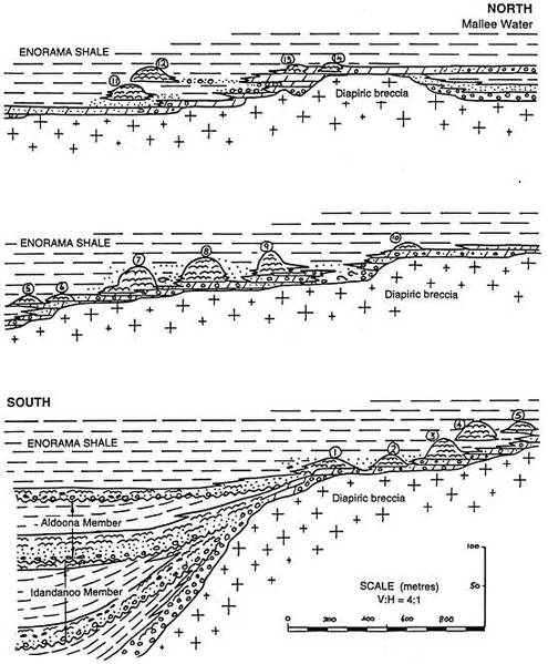
Cross section through the Enorama Diapir and Enorama Shale. The small biogenic mounds (numbered) and reefs become progressively younger to the North (moving upsection) in response to gradual rise in SL and flooding of the diapir, eventually resulting in death of the reefs and subsequent burial under the deeper water Enorama Shale (Lemon, 2000).
Overlying these interglacial sediments is the Yerelina Subgroup the second glacigenic sequence of the Umberatana Group, deposited during the Marinoan Glaciation. This is characterized by shallow water sandstones and lenticular diamictites, such as in the Elatina Formation. The top of the Yerelina Subgroup is overlain with a thin cap dolomite, the Nuccaleena Formation. δ13C depletion (-1 to -3‰) is observed in this cap carbonate, consistent both basinwide and between Marinoan cap carbonates elsewhere. Continued movement of the Enorama Diapir after the Umberatana Group was deposited has resulted in tilting of the units, which now dip away to the east and west of the diapir. The oldest units of the Umberatana Group are brought to the surface nearest the diapir (such as the Sturtian glacial sediments of the Wilyerpa Formation), progressing upsection to the east and west through the complete group until the youngest formation, the Elatina Formation, is exposed along with the overlying cap carbonate of the Wilpena Group.