This phase comprises a single stage that falls in the Bajocian, between 175.0 Ma and 170.0 Ma. The younger limit is associated with the fit of the Blake Spur Magnetic Anomaly of Eastern North America [Klitgord and Schouten, 1986] with a corresponding anomaly in Northwest Africa, whereas the older limit of this stage coincides with the onset of an accelerated phase of rifting which culminated in the formation of the first oceanic crust in the Central Atlantic. As discussed in a previous section, during the first few million years the left-lateral motion of Gondwana with respect to Laurasia continued to be transferred from the Atlantic region to the Western Tethys through the Atlas rift system. This model requires that Morocco and Adria remained attached to Laurasia during this initial period (Fig. 3). Similarly, spreading in the Pindos Basin persisted until 172.0 Ma, when the ridge jumped northward into the Liguride Basin initiating sea floor spreading in the Alpine Tethys, and transtensional motion between Iberia and Morocco.
Table 2. Rotation model for the major Mediterranean microplates. Only Jurassic and Cretaceous Euler poles are shown. The fit of Arabia to Africa was proposed by LePichon and Gaullier [1988]
Table 2. Rotation model for the major Mediterranean microplates
| Age | Lat | Lon | Angle | Reference Plate |
|---|---|---|---|---|
| Adria | ||||
| 67.7 | -35.54 | 194.61 | 18.33 | Northeast Africa |
| 72.5 | -35.54 | 194.61 | 18.33 | Northeast Africa |
| 72.5 | -33.2 | 185.02 | 24.74 | Iberia |
| 80.2 | -33.2 | 185.02 | 24.74 | Iberia |
| 80.2 | -35.3 | 194.5 | 18.3 | Northeast Africa |
| 172 | -35.3 | 194.5 | 18.3 | Northeast Africa |
| 175 | -31.29 | 195.84 | 16.62 | Northeast Africa |
| 200 | -31.29 | 195.84 | 16.62 | Northeast Africa |
| Pelagonian | ||||
| 67.7 | 68.34 | 331.04 | 2.37 | Adria |
| 172 | 68.34 | 331.04 | 2.37 | Adria |
| 175 | 62.07 | 225.26 | 0.36 | Adria |
| 200 | 62.07 | 225.26 | 0.36 | Adria |
| Southern Turkey | ||||
| 67.7 | -33.71 | 220.83 | 13.86 | Arabia |
| 72.5 | -33.71 | 220.83 | 13.86 | Arabia |
| 72.5 | -32.02 | 201.13 | 25.44 | Iberia |
| 74.3 | -32.02 | 201.13 | 25.44 | Iberia |
| 74.3 | -33.22 | 220.6 | 13.83 | Arabia |
| 200 | -33.22 | 220.6 | 13.83 | Arabia |
| Vardar Ocean | ||||
| 67.7 | 67.26 | 1.69 | 17.46 | Northeast Africa |
| 120.4 | 67.26 | 1.69 | 17.46 | Northeast Africa |
| 126.7 | 65.61 | 5.16 | 14.71 | Northeast Africa |
| 130 | 64.3 | 7.93 | 12.81 | Northeast Africa |
| 131.9 | 63.63 | 8.42 | 11.84 | Northeast Africa |
| 139.6 | 62.44 | 4.46 | 8.89 | Northeast Africa |
| 147.7 | 61.69 | 359.48 | 5.4 | Northeast Africa |
| 154.3 | 69.34 | 3.49 | 3.51 | Northeast Africa |
| 170 | 0 | 0 | 0 | Northeast Africa |
| 200 | 0 | 0 | 0 | Northeast Africa |
| Arabia | ||||
| 67.7 | 32.13 | 22.58 | -6.36 | Northeast Africa |
| 200 | 32.13 | 22.58 | -6.36 | Northeast Africa |
| Northern Turkey | ||||
| 67.7 | -26.58 | 205.76 | 35.47 | Eurasia |
| 72.5 | -25.16 | 205.2 | 35.37 | Eurasia |
| 74.3 | -25.16 | 205.2 | 35.37 | Eurasia |
| 80.2 | -22.69 | 202.44 | 30.78 | Eurasia |
| 83.5 | -19.07 | 197.98 | 25.62 | Eurasia |
| 87 | -18.29 | 197.47 | 26.65 | Eurasia |
| 87 | 8.94 | 239.36 | 14.36 | Northeast Africa |
| 120.4 | 8.94 | 239.36 | 14.36 | Northeast Africa |
| 120.4 | -34.32 | 215.58 | 23.24 | Vardar |
| 170 | -34.32 | 215.58 | 23.24 | Vardar |
| 170 | -34.32 | 215.58 | 23.24 | Northeast Africa |
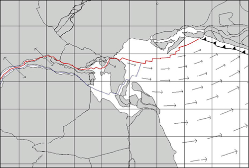
A rotation model for the Mediterranean microplates during the Jurassic and the Cretaceous is shown in Table 2. Figure 5 illustrates the paleogeographic configuration at 170.0 Ma and the corresponding velocity field. Sea floor spreading rates during this stage range from the 65 mm/yr of the southern Central Atlantic to the 33 mm/yr of the Liguride Ocean and the 23 mm/yr of the Northeastern Tethys. A subduction zone at the southern margin of Eurasia was fully established from Sanandaj to Armenia and the Eastern Pontides [Robertson and Dixon, 1984]. A description of the main geologic and structural features of the assemblage of slivers that developed above the subduction zone by oblique convergence can be found in McCall [1996].
Figure 5. Reconstruction at 170.0 Ma (Upper Bajocian)
Vectors represent direction and magnitude of the relative velocity field between Northern Gondwana and Laurasia. Blue line represents the modeled 172.0 Ma isochron. The instantaneous Euler pole location is marked by a small empty circle.
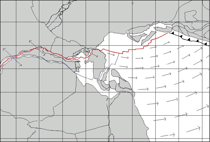
An abrupt change of the absolute velocity of Laurasia at 170.0 Ma occurred at the end of this initial stage. The acceleration field shown in Figure 6 indicates that the Central Atlantic and Liguride ridges were only affected in the spreading rate, whereas transform azimuths remained unchanged. However, a tensional stress field in the Tethyan realm was generated that caused decoupling of the oceanic lithosphere from the Northern Gondwana margin and rifting of microcontinents, the largest being represented by the Northern Turkey. Evidence of this event can be found in the Sakarya zone [Okay, 1984 ; Yilmaz et al., 1995], where basal conglomerates of the Lower Lias are overlain by sandstones, then by neritic carbonates (until the Late Jurassic), finally by hemipelagic cherty limestones during the Early Cretaceous. The oceanic plate that formed at 170.0 Ma, corresponding to the Vardar Ocean of Şengör et al. [1984], existed as an independent plate until chron M0 (120.4 Ma). Following Şengör and Yilmaz [1981], we will use the term “Inner Tauride Ocean” to indicate the oceanic crust that formed to the South of Sakarya and Kirsehir and that progressively separated these blocks from the Menderes-Tauride platform.
Figure 6. Acceleration field at 170.0 Ma (Upper Bajocian)
Vectors represent direction and magnitude of the relative acceleration field Laurasia with respect to Northern Gondwana. Dashed line represents a modelled trend of the incipient spreading center associated to the birth of the Vardar Ocean. The instantaneous Euler pole of acceleration is marked by a small empty circle.