In this paper a simplified set of tectonic elements is used to illustrate the kinematic evolution of the Mediterranean region during the Jurassic and the Cretaceous. In particular, attention is focused on the formation of new plate boundaries in the Tethys realm in response to temporal variations of the velocity field between the large surrounding plates. Therefore, a complete and detailed classification of the microplates involved is not necessary. As the strongest phase of deformation occurred in the Cenozoic, four simple or composite blocks can be used to illustrate the main paleogeographic features. These tectonic elements are: Adria, the Pelagonian terrane, Southern Turkey, and Northern Turkey.
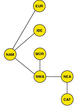
We consider Adria (Fig. 1) as the undeformed assemblage resulting from Permian and Triassic rifting episodes, and comprising the present South Alpine and Northern Apenninic domains, the Apulian promontory and the undeformed Panormide platform (that is, the Southern Apenninic domain of Dewey et. al. [1989] or Turco and Zuppetta [1998]). The Pelagonian terrane is defined by the crystalline and sedimentary formations of Northwest Macedonia and Central Greece that are bounded by the Sub-Pelagonian zone and the Pindos ophiolites to the West, and by the basal thrust of the Vardar zone to the East [Mountrakis, 1984]. Southern Turkey is considered here as the undeformed assemblage comprising the Menderes Massif, the Cycladic units, Crete and the Taurides belt. Finally, Northern Turkey is viewed as a composite microplate comprising the Sakarya and Kirsehir units. It is assumed that all these microplates behaved as rigid elements during the Jurassic and the Cretaceous.
A kinematic model for the major plates surrounding the Mediterranean region is shown in table 1.
The initial fit of North America to Northwest Africa is based on the Blake Spur Magnetic Anomaly of Eastern North America and a pre-stretching match of the continental margins [Klitgord and Schouten, 1986], whereas the North Atlantic fit is based on the reconstructions of Rowley and Lottes [1988] for the North Atlantic and Arctic regions. The starting configuration of the continents around the Tethys at the beginning of the Jurassic (200 Ma, Lower Sinemurian) is illustrated in Figure 1. This fit also takes into account of the pattern of deformation in Africa during the Cretaceous [Wilson and Guiraud, 1992 ; Genik, 1992 ; Guiraud and Maurin, 1992], by restoring the North African blocks to their initial orientations with respect to Central Africa. This includes the closure of the West African Rift System (WARS), and the restoration of transcurrent motion along the Central African Shear Zone (CASZ).
Figure 2. Jurassic and Cretaceous plate motions
The global circuit used to describe the Jurassic and Cretaceous plate motions around the Atlantic and Tethys oceans. The reference plate is Central Africa, which has been oriented with respect to a paleomagnetic reference frame using the method of Schettino and Scotese [2001]. According to this method, a synthetic and smoothed Apparent Polar Wander Path (APWP) for Central Africa was generated by restoring paleopoles from other continents to the Central African reference frame via the global rotation model [e.g., Besse and Curtillot, 1991 ; Bocharova and Scotese, 1993 ; Van der Voo, 1993]. Further details about this method will be published elsewhere [Schettino and Scotese, in prep.].
Finite rotations that describe the pattern of seafloor spreading in the Central Atlantic have been calculated according to the digital compilation of isochrons of Royer et al. [1992] and the ocean floor age grid [Müller et al., 1997]. The finite rotations of Rowley and Lottes [1988] were adopted for the North Atlantic region because these rotations give the best results when paleopoles from Eurasia are transferred to Central Africa via the global circuit.
Figure 2. Global circuit for the plates surrounding the Atlantic and Tethys oceans.
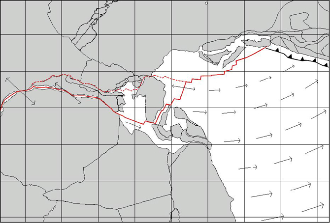
An important feature of the model proposed in this paper is the definition of the Atlas and Rif-Tell regions as a composite tectonic element which rifted from the Northwest African plate during the Late Triassic – Early Jurassic. In fact, the inclusion of this terrane helps to better explain the connection between the early stages of rifting in the Central Atlantic and the tectonic activity in the Mediterranean region during the Late Triassic and the Early Jurassic. A summary of the main geologic and structural features of the Atlas region can be found in Beauchamp et al. [1996]. Here attention is focused on the Late Triassic - Early Jurassic phase of extension and rifting, which produced an aulacogen in the High Atlas region and transtensional features in the Eastern Mediterranean. These events are correlated with the formation of the Newark Basin in the eastern United States [e.g. Olsen, 1997] and the Pindos Basin in the eastern Mediterranean [Degnan and Robertson, 1998]. These three extensional systems were part of a single divergent boundary that crossed Central Pangea during the Late Triassic and the Early Jurassic (Fig. 3). This boundary existed for about 50 Myrs until an abrupt change in the relative velocity of Africa with respect to North America resulted in the cessation spreading along the Pindos spreading center at 172 Ma, as evidenced by youngest radiometric ages of the Pindos ophiolites [Spray et al., 1984]. This event also coincides with extinction of the Atlas rift system as a major plate boundary and the northward jump of the shear zones between Iberia and Morocco.
Figure 3. Reconstruction at 172.0 Ma (Upper Bajocian)

Vectors represent direction and magnitude of the relative velocity field between Northern Gondwana and Laurasia. Dashed line represents an incipient spreading center. Red line marks the assumed trend of the Pindos ridge and the eastern North America and Atlas rift systems.