The Mediterranean region traditionally represents a difficult but intriguing study area for plate tectonic modeling. During the last three decades many workers from almost all disciplines of geology and geophysics have tried to illustrate the geologic evolution of this region from different perspectives and using a variety of geological or geophysical data. It is meaningful that over 700 Jurassic, Cretaceous and Cenozoic paleopoles have been determined for the plates and microplates of the Mediterranean region, whereas only 126 paleopoles are listed in the Global Paleomagnetic Database (GPMDB) for the North American craton [McElhinny and Lock, 1990].
The main problem that researchers have faced has been to identify and map the dozens of microplates involved in the Alpine-Himalayan collision. It is often difficult to identify the ancient boundaries between these tectonic elements (e.g., Pelagonian, the Austroalpine). However, even when the boundaries are well established, a high degree of uncertainty remains with regard to the original undeformed shape of these small tectonic blocks. Additionally, for some of the identified elements, it is still not clear whether they are continental or oceanic terranes. For instance, it is still uncertain if the Panormide carbonate platform was built on a rifted continental margin or if it developed on thickened oceanic crust.
A second problem arises from the absence of direct kinematic constraints for most of the Mediterranean microplates. The best way to accurately assess the rotation parameters of a plate or smaller tectonic element is through the identification of marine magnetic anomalies. Unfortunately, the few and sparse remnants of Mesozoic and Cenozoic oceanic crust of the Mediterranean basin do not provide sufficient information for this purpose. This lack of data was partially overcome by the relatively high number of paleomagnetic studies, which were followed by several quantitative reconstructions of the Mesozoic and Cenozoic paleogeography of the Tethyan realm [e.g., Van den Berg and Zijderveld, 1982 ; Lauer, 1984 ; Morris and Tarling, 1996 ; Channel, 1996 ; Muttoni et al., 1996].
Previous investigations of the tectonic history of the Mediterranean region have followed either qualitative or quantitative approaches. Studies that fall in the first category are based prevalently on geologic data. Examples of this kind of reconstructions can be found in Robertson and Dixon [1984], Şengör et al. [1984], Dercourt et al. [1986], Stampfli et al. [1991], Dercourt et al. [1993], Robertson et al. [1996], Robertson [1998], and Stampfli et al. [1998]. The second group comprises works that highlight the kinematic and structural aspects of the problem [e.g., Dewey et al., 1973 ; Dewey et al., 1989 ; Alvarez, 1991], or those studies that are based on interpretations of paleomagnetic data.
In this paper a new quantitative model of the tectonic history of the Mediterranean region is proposed, which is based on the analysis of variations of the global plate motions and plate circuits, and the identification of corresponding constraints to the local kinematics of small microplates at the interface between Africa and Eurasia during the Jurassic and the Cretaceous. Unlike other classic quantitative studies [e.g., Dewey et al., 1989], theoretical arguments and data are presented to support the idea that the local velocity of intervening microplates is constrained by global variations in plate velocities at stage boundaries (and the corresponding stress fields) and not, as proposed by previous authors, by the path of relative motion of Africa with respect to Eurasia. Therefore, we propose that the relationship between global plate motions and local microplate kinematics is, at best, indirect, whereas a direct connection exists between variations of relative velocity fields of the major plates and the local deformation pattern as expressed by microplate formation and subsequent motion.
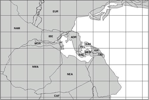
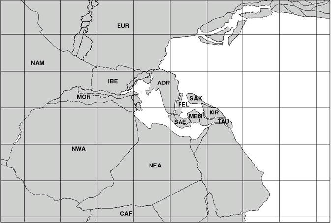
The starting point of this study is a revised global plate tectonic model for the Jurassic, Cretaceous and Cenozoic times [Schettino and Scotese, 2000 ; Schettino and Scotese, 2001 ; Schettino and Scotese, 2002, in prep.], and some basic assumptions about the paleogeographic configuration of the western Tethyan realm at the beginning of Jurassic. These assumptions are based on the geological and geophysical evidence for the existence of a Late Permian – Triassic oceanic seaway that separated Adria from the Northern Gondwana margin (Fig. 1). The Imerese and Lagonegro basins in the western Mediterranean [Zappaterra, 1994 ; Pescatore et al., 1999], and the Levant basin in the easternmost Mediterranean [Garfunkel, 1998 ; Robertson, 1998] are well documented domains characterized by pelagic sedimentation during the Triassic. Stampfli et al. [1991] pointed out that the formation of this basin could have been related to the Cimmerian rifting during the Late Permian. However, the Cimmerian rift model requires that an eastward widening of the ocean formed as a result of the counterclockwise rotation of the Cimmerian blocks as they were subducted towards the Eurasian margin. Conversely, we propose an alternative scenario, which results in a westward-widening ocean that opened by clockwise rotation of the Mediterranean terranes with respect to Northern Gondwana. This rifting event may be associated with the extensive Late Triassic rifts of Central Pangea [Veevers, 1989], which culminated at the beginning of Jurassic (about 200 Ma) in the eruption of an enormous quantity of basalts in a geologically short interval and the formation of the Central Atlantic Magmatic Province (CAMP) [Schlische, 1993 ; Olsen, 1997 ; Withjack et al., 1998 ; Hames et al., 2000]. In many aspects, our assumed starting configuration for the Eastern Mediterranean region is similar to the one proposed by Robertson [1998].
Figure 1. Reconstruction of the Tethyan realm at 200.0 Ma (lower Sinemurian)
Labeled tectonic elements are essential protagonists of the Jurassic and Cretaceous history of the Mediterranean region. NWA = Northwest Africa; NEA = Northeast Africa; EUR = Eurasia; MOR = Morocco; IBE = Iberia; ADR = Adria; PEL = Pelagonian; SAE = Southern Aegean; MEN = Menderes; SAK = Sakarya; KIR = Kirsehir; TAU = Taurides; CAF = Central Africa.
The next two sections of this paper illustrate data and methods that were used to construct the proposed model. This is followed by a discussion of the correlation between the kinematic behavior and the geologic events that characterized the geologic history of the Tethyan realm during the Jurassic and the Cretaceous.