After the Hercynian orogeny, the first sediments deposited in the area of the western termination of the axial zone were discontinuous red beds of Permian age. These sediments are discordantly covered by sediments of Late Cretaceous to Late Eocene age [Teixell, 1990a]. The succession begins with Lower Cretaceous (Cenomanian to Santonian) shallow water limestones and dolomites (Calcaires des cañons [Ribis, 1965; Souquet, 1967]). The covering rocks of Santonian to Maastrichtian age consist of a calcareous shale unit (Couche Rouge), which increases in thickness towards the south. In the north, it is unconformably overlain by an onlapping turbiditic sequence, the Longibar turbidites [Teixell, 1990b], which have been dated as Late Campanian to Early Maastrichtian [Ribis, 1965]. In the south, the calcareous shales are overlain by a unit of shelf sandstones, the Marboré sandstones (Maastrichtian). In the northern domain, rocks of Tertiary age are not preserved, while in the south, the Marboré sandstones are overlain by shelf and slope carbonates of Paleocene to earliest Eocene age (Ager formation [Labaume et al., 1985]). These are followed by turbiditic sediments of Eocene age (Hecho group) which are the actual sediments of the Jaca basin.
The Jaca basin was an Eocene marine foreland basin located in the Southern Pyrenees. Today, it is exposed in the South Pyrenean thrust zone (Fig. 1). During Ypressian and Lutetian time, the basin was an east-west elongated through, filled with a thick turbiditic wedge (Hecho group), that thinned southwards [Mutti et al., 1984]. The northern border was formed by the active Lakhoura (or Eaux-Chaudes) basement thrust sheets [Labaume et al., 1985; Teixell, 1992]. To the south the trough was flanked by carbonate platforms [Puigdefàbregas and Souquet, 1986; Barnolas et al., 1991]. The turbidite wedge is 50 km wide and 4,5 km in maximum thickness [Teixell, 1992] and shows a south directed onlap [Labaume et al., 1985], which is the same direction as the advance of the thrust sheets. The sedimentary infill of the basin consists of terrigenous turbidites and thick carbonate megabreccia sheets or megabeds. The terrigenous turbidites were fed axially by deltaic shelves located to the east, on top of a thrust unit (Tremp-Graus basin) and mainly consist of siliciclastic material. The origin of the megabreccia sheets is controversial. Early papers suggested an origin in the hinterland, from hypothetical carbonate platforms (now eroded away), which were sitting on top of active thrust sheets [Mutti et al., 1984; Séguret et al., 1984; Labaume et al., 1985]. This interpretation has been based on paleocurrent directions in these megabeds and facies associations in carbonate turbidites. However, an origin in the south has also been proposed [Barnolas and Teixell, 1994]. This interpretation is based on the nature of the erosional contacts of the megabeds and the carbonate platforms in the south, the thinning and fining upward trends of some of the megabeds and the existence of the platforms in the south.
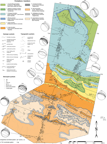
The rocks exposed in the study area are Campanian/Maastrichtian to Middle Eocene sediments. The oldest rocks are situated in the north and become progressively younger towards the south (Fig. 5). The rocks have been subdivided into eight formations. The oldest formation is the Couche Rouge formation, which consists of distal shelf calcareous shales and contains the deep-water foraminifer Navarella joaquini (Campanian to Maastrichtian) [Puigdefàbregas and Souquet, 1986]. In the north, these rocks are overlain by a series of calcareous turbiditic sediments, which mainly consist of limestone beds interbedded with shale beds (Ochogorri formation). Sometimes there are thin-bedded siliciclastic turbiditic layers present between the limestone and shale beds. These deposits have been dated at Late Paleocene age (and possibly up to Early Eocene age) and are interpreted to be the southward continuation of the Longibar turbiditic series, which are of Late Campanian to Early Maastrichtian age [Ribis, 1965]. These rocks are situated above the westward plunging axial zone antiform. In the south, the Couche Rouge formation is overlain by a platform carbonate of Paleocene age, the Ager formation [Labaume et al., 1985; Puigdefàbregas and Souquet, 1986; Teixell, 1990]. This platform carbonate shows a rapid southward increase in thickness from ~ 50 m in the north to ~ 300 m in the south. The northern (thinner) part consists of carbonate slope deposits and the southern (thicker) part consists of platform and shelf carbonates. In the south the platform carbonate is overlain by a series of siliciclastic turbiditic deposits with interbedded resedimented thick carbonate megabreccia sheets or megabeds (Hecho group) of Early to Middle Eocene age [Mutti et al., 1972; Labaume et al., 1985]. These deposits have been subdivided into five formations consisting of three packages of turbiditic material separated by two megabeds, referred to as (from old to young) the Isaba, Urzainqui, Roncal, Ardibidipicua and Santa Bárbara formation. Below, a detailed description of the formations and the separate stratigraphic columns is given.
Figure 5. Geological map of the Belague valley and the Minchale valley
Geological map of the Belague valley and the Minchale valley, located in the Southern Pyrenees, west of the axial zone, between the village Roncal in the South and the French-Spanich border in the north (see Fig. 3 for exact location). The stratigraphic columns are plotted in Fig. 6 and the cross-sections are plotted in Fig. 7.
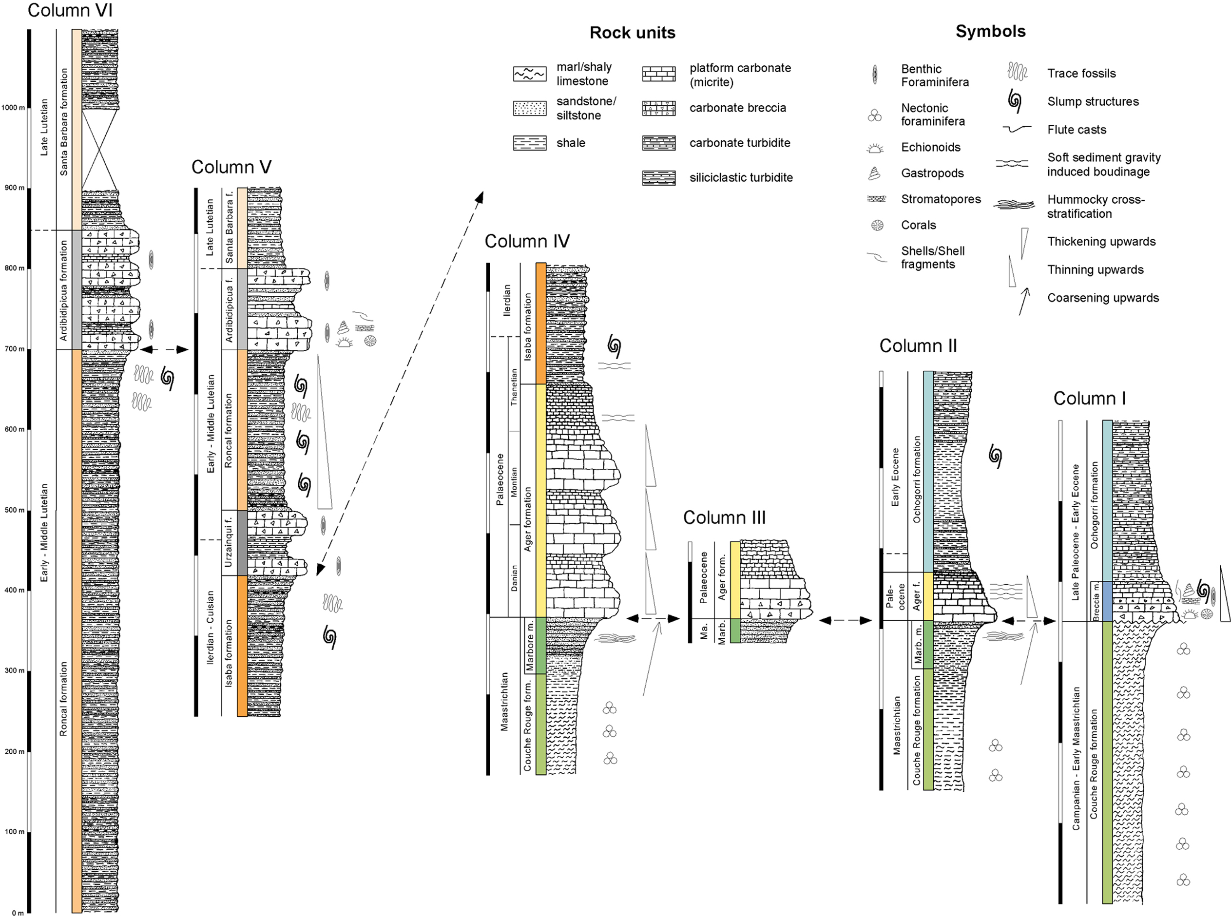
Six correlated stratigraphic columns have been plotted in Fig. 6. The geographical positions of these columns can be seen on the geological map (Fig. 5). Below a short description of each column is presented, followed by a short section about the correlation of the columns.
Figure 6. Plots of six stratigraphic columns
Plots of six stratigraphic columns. For location of columns see Fig. 5. For description of each individual column see text.
The northernmost column (column 1) begins with a minimum of ~ 350 m of shaly marls, which contain various deepwater foraminifera (Pseudotextularia sp., Globotruncana stuarti, Globotruncana elevata, Hetrohelix sp.). The lowermost part has been dated as Campanian and the uppermost part has been dated as Early Maastrichtian. These sediments are discordantly covered by a package of ~ 50 m of limestone breccias (Breccia member), containing clasts of up to 50 cm. The member contains numerous fossils, such as foraminifera (Discocyclina seunesi, Assilina sp.), algae rodoficeas (Lithotamnium), hexacorals, stromatolites and gastropods. From determination of the foraminifera, the lowermost part of this sequence has been dated as Late Paleocene (Thanetian), indicating that there is a considerable time gap present between this formation and the underlying shaly marls. The breccia deposits are concordantly followed by at least 200 m of well-bedded carbonate turbidites with alternating limestone and shale beds. These deposits are of Late Paleocene age but could also become as young as Early Eocene. The uppermost 250 m of the column show a thinning upward trend.
The second column starts with ~ 150 m calcareous shale (Campanian-Maastrichtian), followed by some 60 m of a coarsening upwards sequence of silty shale at the bottom to siltstone at the top (Maastrichtian). These are covered by nearly 60 m of a thinning upwards sequence of micritic mudstones beds (Paleocene), with thick-bedded to massive beds at the bottom and thin-bedded beds at the top. The intermediate bedded limestones in the middle show patterns of soft sediment gravity induced boudinage (probably caused by the gravitational gliding along the slope on which they were deposited). The limestones are covered by at least 150 m of turbiditic deposits (Early Eocene), with about 10-20% of sandstone beds and a maximum bed-thickness of 10 cm.
The third column starts with some 50 m of siltstones to fine sandstones (Maastrichtian), and are followed by at least 80 m of carbonate rocks (Paleocene). The lowermost 40 m of these carbonates consist of carbonate breccias with a micrite matrix and micrite clasts of up to 1 m. These carbonates are probably slope deposits of the Paleocene carbonate platform situated more to the south.
The next column (column 4) starts with at least 125 m of shaly marls with numerous pelagic foraminifera (Globotruncana sp.), which change to calcareous shales, and finally become finegrained sandstones with hummockey cross-stratification in the last 70 m (Maastrichtian). These siliciclastic sediments are covered by some 290 m of micritic mudstones (Paleocene) in which three fining upwards sequences are present. The uppermost part of these limestones consists of thin-bedded limestones with wavy lamination, indicating a change to a deeper water depositional environment. It contains sporadic benthic foraminifera (Globigerina sp. and Globorotalia sp.) and some small fragments of echinoderms. This part has been dated as Paleocene and possibly Early Eocene. These sediments are followed by some 4 m of shales, which themselves are followed by at least 150 m of siliciclastic turbidites (Early Eocene), with about 40% sandstone beds. The transition of carbonates to turbidites indicates a rapid drowning of the platform. The turbiditic sandstone beds show patterns of soft sediment gravity induced boudinage (especially in the lowermost 50 m), indicating that they were deposited on a slope.
The fifth column (column 5) consists of turbidites and megabeds (Early to Middle Eocene). In this column two megabeds can be recognised. The megabeds predominantly consist of limestone breccia clasts of up to 1m and numerous foraminifera (Numulites sp., Assilina sp. and Discocyclina sp.) within a micrite matrix. The turbiditic deposits mainly consist of siliciclastic material with sandstone beds interbedded with shale beds. The percentage of shales varies along the column.
The last column (column 6) consists of at least 700 m of turbidites of the Roncal formation, covered by the megabed of the Ardibidipicua formation (Cuisian). This is probably covered by at least ~ 250 m of turbidites (Cuisian-Lutetian).
From correlation of the first four columns, it can be concluded that during Late Cretaceous times, the depositional environment changed from a deep water distal marine environment in the north (column 1), to slope environment (column 2), to shallow marine environment (column 3, 4) in the south. During Paleocene times, a deep marine environment remained in the north, where carbonate turbidites were deposited (column 1). Towards the south, the environment changed to platform slope (column 2, 3) and finally to platform interior, with deposition of a thick succession of carbonate mudstones (column 4). During Eocene times, turbiditic deposition shifted towards the south on top of the drowning carbonate platform (column 4). Further to the south, more turbiditic sediments were deposited, with at least two interlayered carbonate megabreccia sheets (column 5). Column 6 shows a very rapid increase in thickness of the turbiditic sediments of the Roncal formation, compared with column 5, which is interpreted to be related to synsedimentary thrusting along the Urzainqui thrust, in front of which most sediments were deposited.