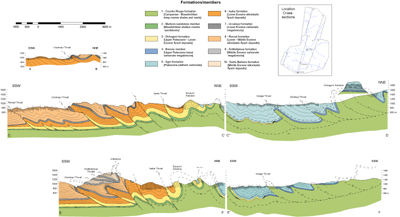
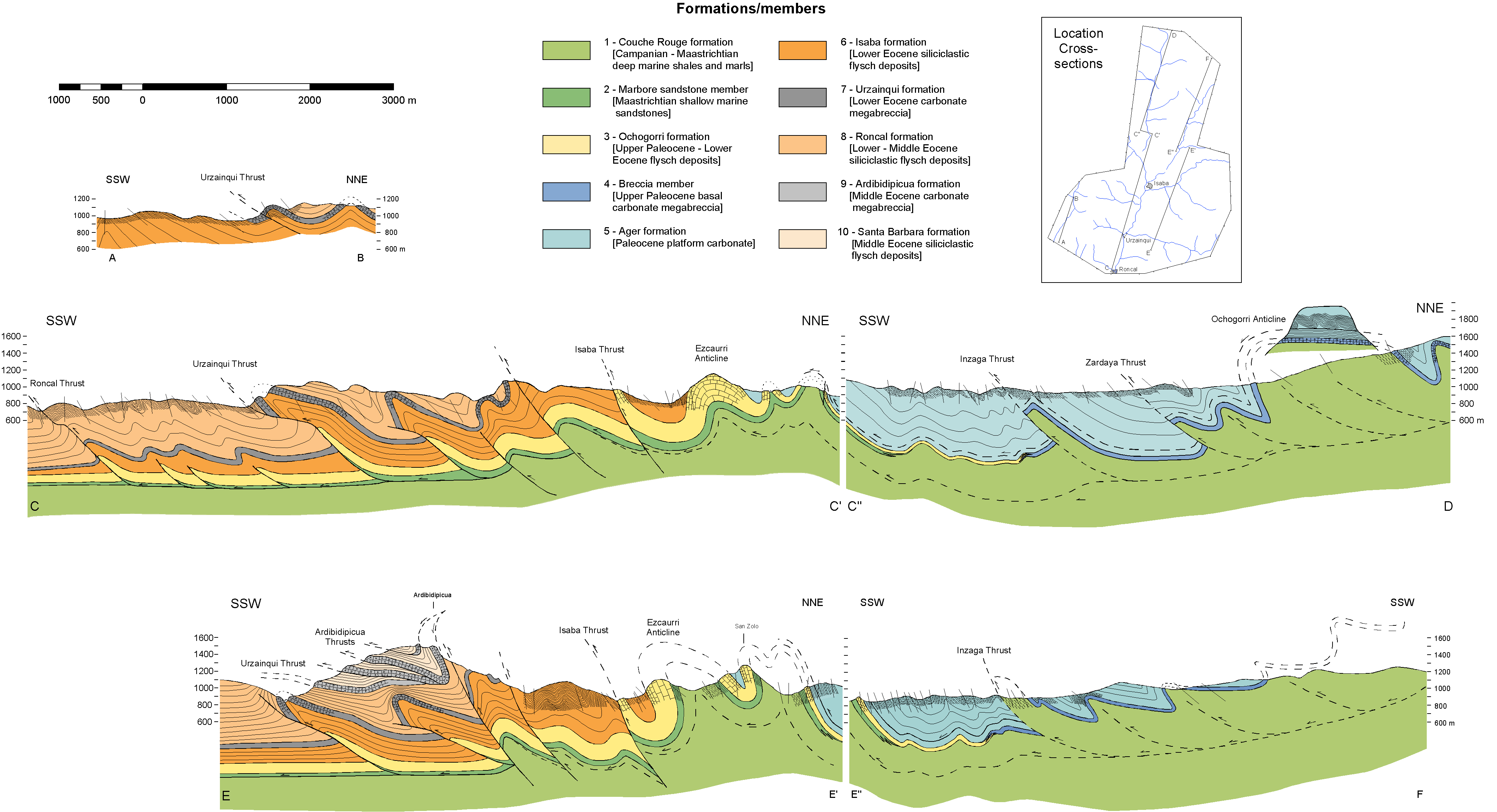
The study area is located around the western termination of the axial zone, which is in the Mesozoic-Cenozoic cover above the west dipping axial zone and the northernmost part of the South Pyrenean thrust zone. The basement in this area forms thrust sheets with a little degree of overlap (Fig. 2b, Fig. 4) [Laboume et al., 1985; Teixell, 1996, 1998], which is markedly different from the antiformal stack geometry in the eastern part of the Pyrenees (Fig. 2a) [Muñoz, 1992]. The dominant structural trend in the area is WNW-ESE with a SSW vergence. The deformation type is typically of upper crustal levels and shows no metamorphism. The area can be divided into four zones (Fig. 3), which are from north to south [Teixell, 1996]: (1) The Lakhoura thrust sheet, (2) the axial zone, (3) The Jaca basin (deformed Palaeogene foredeep) and (4) the thrust front of the External Sierras.
North of the axial zone, the Lakhoura thrust sheet [Teixell, 1990a; Teixell, 1996] (also named Eaux-Chaudes thrust sheet [Labaume et al., 1985]) places Hercynian basement rocks and Mesozoic cover on top of the Late Cretaceous cover of the axial zone. The thrust sheet consists of Silurian-Carboniferous rocks, covered with discontinuous sedimentary series of Mesozoic age.
The axial zone antiform consists of Hercynian rocks and a thin cover of Late Cretaceous sediments. It has a profound plunge (about 15° [Teixell, 1990a]) to the west, which affects both the Hercynian basement and the Mesozoic-Cenozoic cover. The antiform shows a flat top, which is affected by normal faults, and a homoclinal gently dipping northern and southern limb [Teixell, 1996]. These limbs are characterised by a system of hectometre-scale overturned south vergent folds, which have an associated axial planar cleavage [Teixell, 1996]. No thrusts affect the basement-cover unconformity and there are no signs of shear deformation at the unconformity [Teixell, 1996]. The sedimentary cover, however, contains numerous folds and thrusts. In the northwest of the dipping antiform, there is a series of imbricate thrusts that involve the upper part of the "Calcaires des cañons" and the overlying calcareous shales (Couche Rouge) [Teixell, 1990a]. These thrusts show typical decametre- to hectometre-scale south directed displacements. These thrusts branch from the same décollement horizon, the Larra floor thrust, which is believed to be branching of the Lakhoura basement thrust [Teixell, 1996]. The displacement on the Larra thrust in the north is transferred to the south to another set of thrusts, located in higher stratigraphic levels. Here the main décollement horizon is situated in the Upper Cretaceous marls (Couche Rouge).
South of the Axial zone lies the Jaca basin, which shows the broad geometry of an asymmetric synform. Its southern limit is defined by the External Sierras. The area can be subdivided in two regions, corresponding to two different levels of exhumation, with a northern part, dominated by the Hecho group and a southern part, dominated by the younger Campodarbe group.
The northern part of the Jaca basin shows two main stages of deformation, as found in the axial zone: an early stage, which consists of a system of gently dipping thrusts, and a second stage of deformation, defined by folds and steeper dipping thrusts and reverse faults [Soler and Puigdefàbregas, 1970; Ten Haaf et al., 1971; Labaume et al., 1985]. The first generation of thrusts shows little associated folding and is believed to be the southern continuation of the Larra thrust [Teixell, 1990], which can be observed in the Sierras Interiores, situated at the southern limb of the axial zone antiform (Fig. 2b, 3). The structure of this area is build up of a series of imbricate thrusts. The sediments involved in this thrusting are the Marboré sandstones (Maastrichtian) and the limestones and turbidites of Paleocene and Eocene age [Soler and Puigdefàbregas, 1970; Ten Haaf et al., 1971; Labaume et al., 1985]. The floor thrust in this area is located between the calcareous shale (Couche Rouge) and the overlying Marboré Sandstone and is considered to be the continuation of the Larra floor thrust [Teixell, 1990a]. The individual thrusts in this area show typical fault propagation fold geometries [Alonso and Teixell, 1992]. The second generation of thrusts is steeper and forms a large imbricate fan with intervening folds varying from metric to kilometric in size. These folds show a distinct southward vergence and may be accompanied by a slaty cleavage. The second stage structures are correlated with the antiform of the axial zone.
In the southern part of the Jaca basin, the first stage of deformation is of little importance and the second stage of folds and steep thrusts is dominant. This second stage of deformation defines the Guarga synclinorium [Puigdefàbregas, 1975]. The folds in this area are upright, with a poorly defined vergence and are of kilometric scale. The folds generally show angular geometries in the cores while the outer arcs are more rounded. The anticlines can be very tight.
The structure of the External Sierras consists of a narrow complex anticline, the Santo Domingo anticline [Almela and Rios, 1951; Nichols, 1987], whose core is disturbed by thrusts. It separates the highly deformed Jaca foreland basin with its flysch sediments from the (more or less) undeformed Ebro molassic foreland basin.
Deformation in the Southwestern Pyrenean Thrust Zone shows an in-sequence development of hinterland dipping basement thrusts [Teixell, 1996]. In general, the cover sediment thrusts developed in an in-sequence order, although out-of-sequence thrusting has also been reported in the Southern Pyrenees [Vergés and Muñoz, 1990; Burbank et al., 1992]. There are three main stages of deformation related to the three basement involved thrusts (Fig. 2b), which are from north to south: the Lakhoura (or Eaux-Chaudes) thrust, the Gavarnie thrust and the Guarga thrust [Teixell, 1996]. The first thrust that formed was the Lakhoura thrust, which resulted from inversion of the North Pyrenean basin margin, slicing off a thin piece of basement. Initiation of the Lakhoura thrust maybe started somewhere in the Late Santonian [Teixell, 1996]. Since the Larra thrust is believed to branch of the Lakhoura thrust, the age of the movement on the Larra thrust could be the age of movement of the last translation of the Lakhoura thrust as a whole. The activity of the Larra thrust has been dated from Middle/Late Lutetian to Bartonian times [Teixell, 1996]. The second basement thrust to be activated was the Gavarnie thrust, resulting in the formation of the axial zone antiform and deformation both the Lakhoura and the Larra thrust and their overlying sediments. This thrusting event was the cause of the second stage of deformation in the Jaca basin, where folds and steep thrusts dominate. The thrust was active from Priabonian to Rupelian times [Puigdefàbregas, 1975: Teixell, 1992]. The main emergence of the External Sierras can be regarded to the activation of the Guarga thrust. This stage of deformation led to the deformation of the entire Jaca basin and has been dated as Middle Rupelian to latest Oligocene - earliest Miocene [Puigdefàbregas and Soler, 1973; Pocoví et al., 1990; Hogan, 1993].
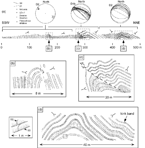
The area of investigation is situated some 15 km to the west of the termination of the axial zone. The area contains several major thrusts, reverse faults and folds. The axes of these folds and thrusts run more or less WNW-ESE (Fig. 5). These thrusts and most of the folds have a vergence towards the SSW (Fig. 7). Structural relationships at key-localities and reconstruction of the cross-sections in the area indicate that there are two main phases of deformation, the first one related to the Lakhoura basement thrust (D1) and the second one to the Gavarnie thrust (D2). The first phase can be subdivided into three subphases, the first subphase (D1a) is related to the first activity of the Lakhoura thrust, the second subphase to the Larra thrust (D1b) and the third subphase to reactivation of the Lakhoura thrust (D1c). In the following paragraph, the large-scale structures of the area will be described in reference to the geological map (Fig. 5) and three cross-sections that have been constructed (Fig. 7).
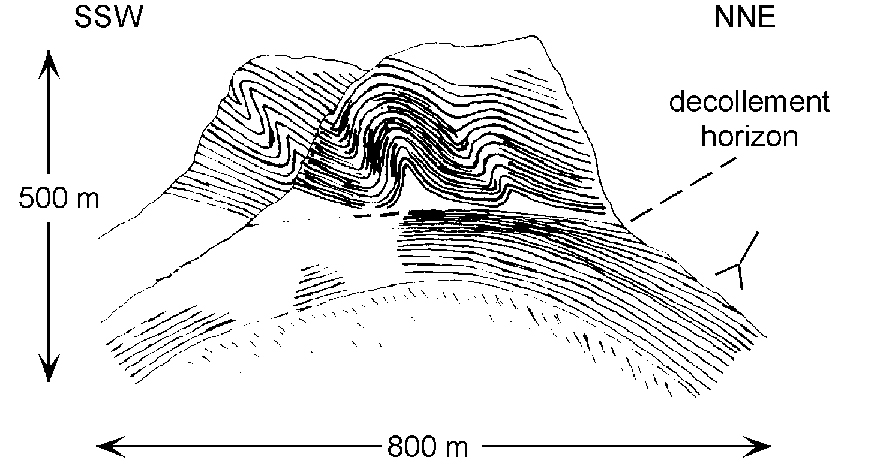
The axial trends of the folds show a rotation of strike from NNW-SSE (320-340°) in the north to WNW-ESE (~290°) in the south (Fig. 5). The northernmost part of the area contains one syncline and two anticlines with fold axes running approximately NNW-SSE to NW-SE from which the southernmost one (Ochogorri anticline) has a relatively large wavelength (~ 2 km) and amplitude (~ 1 km). The Ochogorri anticline folds a thrust plane (Fig. 8), which is probably the southern continuation of the Lakhoura floor thrust. The décollement horizon has been interpreted to be related to an early phase of deformation (D1a), while the folding of the décollement horizon has been interpreted to be related to a later phase of deformation (D1b).
Figure 8. Sketch of outcrop 1
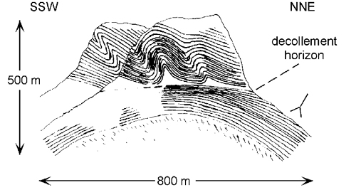
Sketch of outcrop 1 showing the summit the Ochogorri with marls of the Couche Rouge formation at the bottom covered by carbonate turbidites of the Ochogorri formation. The sketch shows a large anticline (D1b) (the Ochogorri anticline), which folds the sediments and a thrust plane, indicating that the thrust plane (D1a) must have been formed before the large fold. The folds above the detachment horizon point to a SSW vergence. In the Couche Rouge formation, only some cleavage is visible.
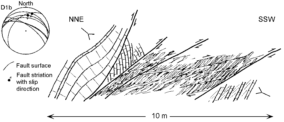
Further to the south there is a region in which the beds are dipping about 30-40° towards the NE. In this zone there is one thrust (Zardaya thrust), running more or less parallel to the bedding. This thrust could be a splay, which branches of the Larra floor thrust. This structure is followed by a zone defined by ~ 100 m scale south vergent folds and one important fault zone, the Inzaga thrust. All the kinematic indicators in the fault zone point to a top-to-the-SSW movement, in agreement with the interpretation that it is a thrust. The thrust is found in the Minchale Valley (Fig. 9) as well as in the Belagua Valley and probably originates from the Larra floor thrust.
Figure 9. Sketch of outcrop 2

Sketch of outcrop 2 showing carbonate turbidites of the Ochogorri formation. The sketch shows a fault zone (Inzaga thrust) with several fault planes and in between fault breccias in which smaller scale shear zones and sigmoidal shaped shear lenses are visible. All the structures have a SSW vergence. To the north of the thrust the rocks consist of medium bedded limestones while to the south of the thrust the rocks consist of sandy limestone beds, interbedded with shale beds (at least 50%). The orientation of several faults is plotted in the stereonet. Fault striations and kinematic indicators point to a top to the SSW movement.
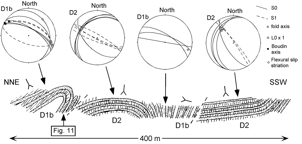
South of the Inzaga thrust there is a zone with two 100 m scale south vergent overturned folds (D1b), which are overprinted by a younger deformation event with associated upright folds and vertical cleavage (Fig. 10) (D2). These younger folds have a steep plunge towards the NW of up to 30¼.
Figure 10. Sketch of outcrop 3
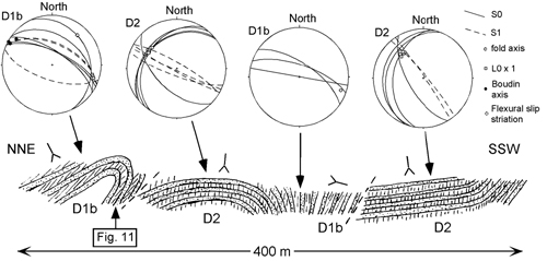
Sketch of outcrop 3 showing medium bedded sandy carbonate turbidites of the Ochogorri formation. Four different zones can be distinguished with each zone belonging to one of two deformation phases. D1b structures have a SSW vergence with overturned folding. D2 structures are characterised by upright folds and associated vertical cleavage with relatively steep fold axes plunging towards the WNW to NW (see stereoplots).
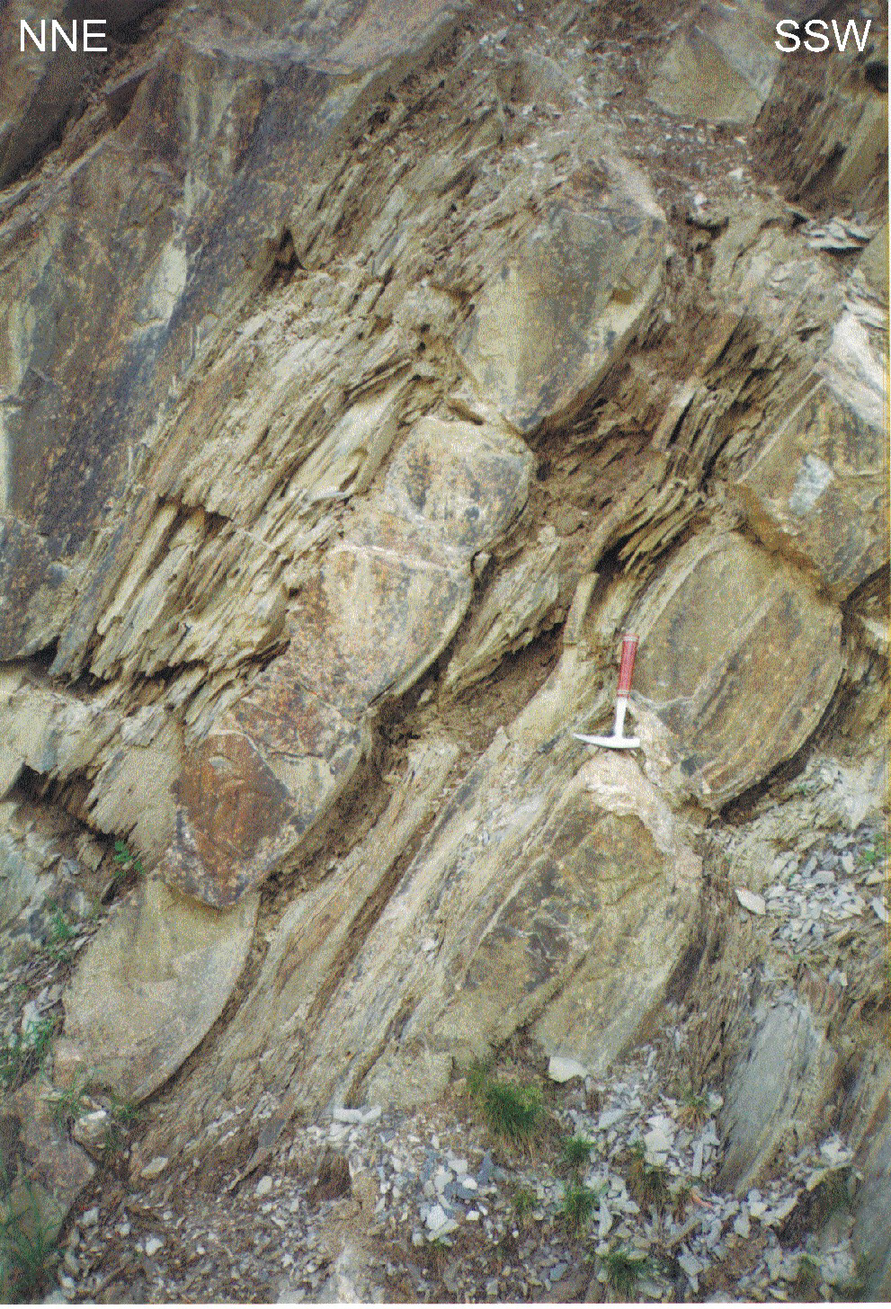
Figure 11. Overturned turbidites with boudin structures
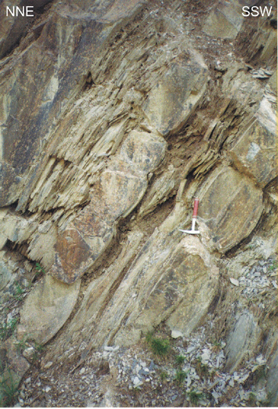
Overturned turbidites with boudin structures from which fold axis can be deduced. Boudins mainly occur in the thicker sandstone beds. Scale is indicated by geological hammer. For location see Fig. 10.
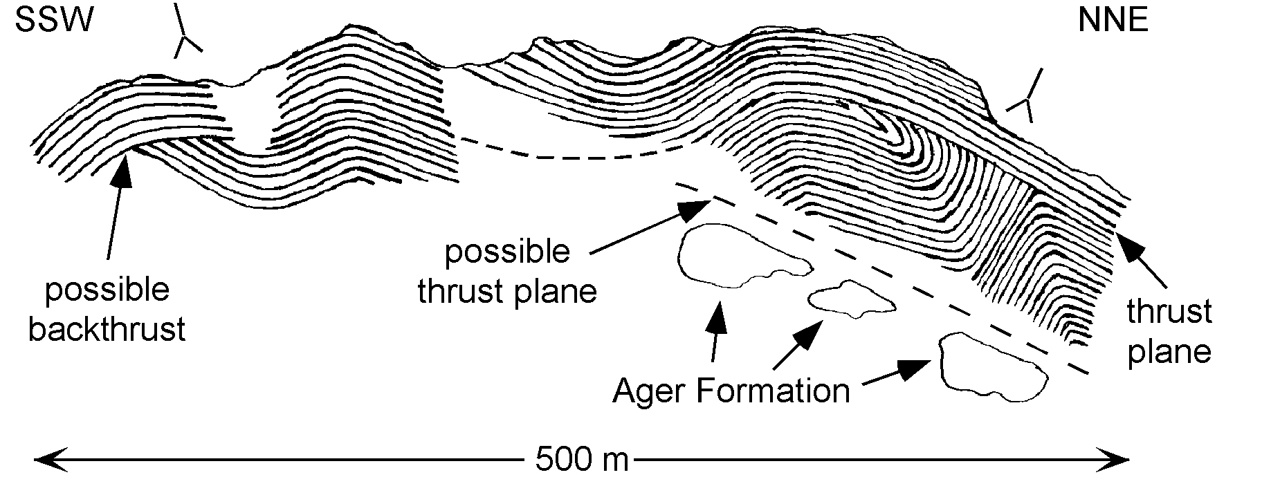
Further to the south the Ager formation comes to the surface where it is folded into three major anticlines (D2). The northernmost two anticlines are slightly overturned to upright and have a wavelength of some 400 m (the Arniota and the San Zolo anticline). The Arniota anticline folds a thrust plane (San Juan thrust), which is probably the southern continuation of the Lakhoura floor thrust (D1a) (Fig. 12). The southernmost anticline is a south vergent overturned fold (Ezcaurri anticline) with a wavelength of some 1200 m, a fold-axis running WNW-ESE and a ~ 10° plunge towards the WNW. The Ezcaurri anticline shows a great lateral continuation towards the ESE of more than 10 km. The Uztarroz syncline, located south of the Ezcaurri anticline, also plunges towards the WNW.
At the southern flank of the Uztarroz syncline, a south vergent reverse fault crops out (Isaba Thrust, D2), which runs more or less parallel to the axis of the folds. Here, the Ager formation reappears and is thrust over folded Eocene turbidites of the Hecho group. These folded turbidites have wavelengths of 10 - 100 m, with southward verging folds in the north and symmetrical to slightly northward verging folds near Isaba.
Figure 12. Sketch of outcrop 5

Sketch of outcrop 5 showing turbidites of the Ochogorri formation and limestones of the Ager formation. The sketch shows a SSW vergent thrust plane indicated by drag of the bedding along the thrust plane. Another possible SSW vergent thrust plane and a possible backthrust are also visible. The thrust planes (D1a) and bedding planes have later been folded into an open anticline (D2) (Arniota anticline).
Further to the south, between Isaba and Urzainqui, the structure is dominated by two folds, which also display a great lateral continuation. The first one is an overturned syncline (Ardibidipicua Syncline, D2), which strikes ~ WNW-ESE. The southernmost one is the Urzainqui fault propagation fold (D1b). In the zone between this syncline and fault propagation fold, there is a stack of several thrust slices, with lengths of a few km and thicknesses of a few hundred metres. The thrusts slices have a vergence towards the SSW. The uppermost three thrust slices are probably the southward continuation of the Lakhoura thrust (D1c), whereas the Urzainqui fault propagation fold is probably the southern continuation of the Larra thrust. On the northern flank of the south vergent Urzainqui fold (D1b), younger north vergent structures have been recognised (D2) (Fig. 13). These structures show NE vergent detail folds, which fold the S1 cleavage. The folds plunge towards the NW at ~ 15-25¼.
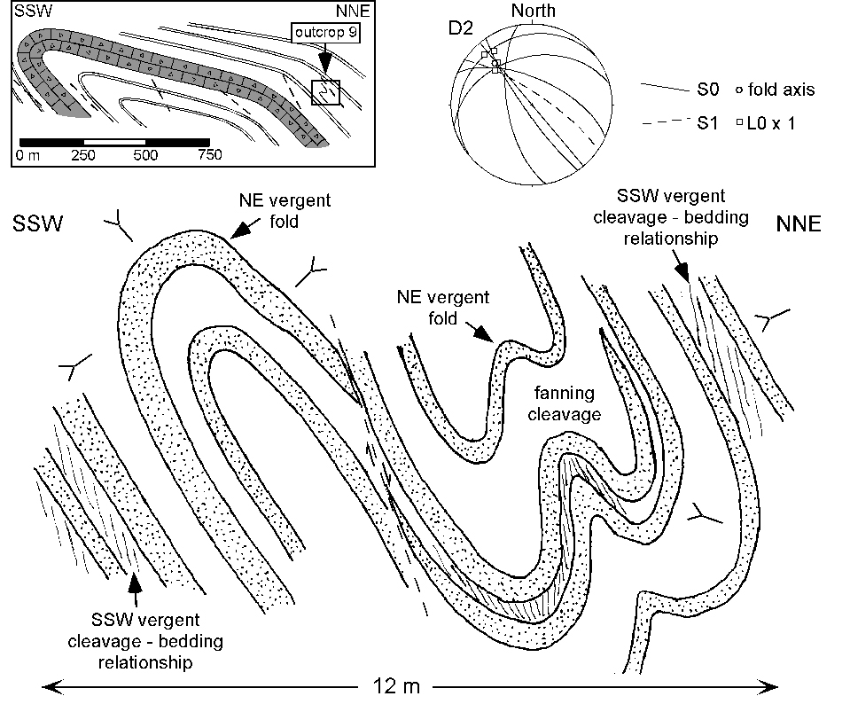
Figure 13. Sketch of road section (outcrop 9)

Sketch of road section (outcrop 9) showing turbidites of the Roncal formation. The sketch shows NE vergent detail folds (D2) in between beds with a SSW vergence (D1b). These detail folds sometimes fold the cleavage related to the SSW vergent structures. The D2 fold axes display a distinct plunge towards the NW (see stereoplot). Location of outcrop with respect to Urzainqui fault propagation fold is shown in inset.
Figure 14. Sketch of outcrop 10
(a) Sketch of outcrop 10 showing a 500 m long road section located north of the vilage of Roncal with deformed turbidites of the Roncal formation. The section shows an open anticline and syncline in the NNE (D2) and a fault propagation fold in the middle (D1b). The part, south of the fault propagation fold contains numerous domino structures in the sandstone beds (see Fig. 15). (b) North vergent cut through detail fold with overturned beds at both sides of the fault (determined from stratigraphic markers and relationship between sedimentary bedding and cleavage. (c) South vergent fault popagation fold which runs ~ parallel to the beds in the lower right corner, forming flats in both hangingwall and footwall. In the middle and upper left corner the thrust cuts through both hangingwall and footwall, forming ramps. Here the beds show drag along the fault. (d) Roughly symmetrical open anticline with vertical cleavage and meter scale kinkbands, which seem to dominate in the northern part. The small inset shows refraction of the cleavage in some of the thicker beds, rotating more parallel to the bedding planes with increasing grain size.
To the south of the Urzainqui fault propagation fold, there are numerous short wavelength folds, with wavelengths varying between a few and several hundred metres. They strike ~ WNW-ESE and have a SSW vergence. North of the village Roncal, two open upright folds (D2) strike WNW-ESE (Fig. 14). The folds have an associated vertical cleavage and meter scale kink bands. Occasionally, the cleavage shows refraction in some of the thicker beds, turning more parallel to the beds with increasing grain size (Fig. 14d, inset). Just south of these folds there is a south vergent fault propagation fold (Roncal thrust) with a similar trending axis (D1b) (Fig. 14).
Figure 15 shows domino structures, found in sandstone beds in the southern part of Fig. 14. The thick sandstone beds show domino structures, which have resulted from sinistral shear. For this reason, they are not related to the fault propagation fold of the first deformation phase (D1), because flexural-slip along the individual beds during formation of the fault propagation fold would impose a dextral sense of shear on the southern side of this anticline. The oldest cleavage (S1) shows that it has been deformed by the rotating blocks of the sandstone beds. A younger cleavage can also be observed (S2). Therefore, the domino structures are most likely related to the symmetrical syncline located towards the north (D2), which would impose a sinistral shear flexural slip on its southern flank.
Figure 15. Domino structures
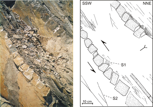
(a) Photo and (b) interpretation of overturned turbidites of the Roncal formation. The picture shows domino structures in sandstone beds. The dominos deform an older cleavage (S1). There is also a younger cleavage present (S2). These structures point to sinistral shear along the bedding planes, indicating that they are related to the symmetrical syncline in Fig. 14a and not to the fault propagation fold, which would impose dextral shear on the sandstone beds.
The Roncal formation (turbiditic flysch deposits) shows a great change in thickness across the Urzainqui fault propagation fold (Fig. 6). Its thickness increases from some 200 m in the hangingwall to at least 700 m in the footwall (Fig. 7, cross-section A-B and E-F). This increase in thickness can probably be attributed to syntectonic sedimentation, where the emergence of the thrust sheets in the north led to a decrease in accommodation space above the thrust sheet. This has subsequently led to more abundant sedimentation south of the Urzainqui thrust. The Roncal formation was deposited during the Middle Lutetian [Puigdefàbregas and Sánchez Carpintero, 1978a,b], indicating a similar age for the Urzainqui thrust. The activity of the Urzainqui thrust probably seized after deposition of the Ardibidipicua formation, since it is also deformed by the underlying structure (Fig. 5, 7), but to a lesser degree compared to deformation of the Urzainqui formation. Since the Larra thrust was probably active during Middle-Late Lutetian to Bartonian times [Montes, 1992] and the Gavarnie thrust during Priabonian to Rupelian times [Puigdefàbregas, 1975; Teixell, 1992], the Urzainqui thrust is most likely connected to the Larra floor thrust.
The timing of this syntectonic sedimentation and activity of the Urzainqui thrust has a profound influence on the timing of the thrusting activity of the Ardibidipicua thrusts. These thrusts cut through the Ardibidipicua formation, which has been deposited on top of the Roncal formation, and are therefore younger than the Roncal formation. This leads to the conclusion that the Ardibidipicua thrusts have to be younger than the Urzainqui thrust. Furthermore, the Urzainqui thrust has been related to the Larra thrust [Labaume et al., 1985] and the Ardibidipicua thrusts have been related to the Lakhoura thrust [Labaume et al., 1985], where the Larra thrust is thought to be younger than the Lakhoura thrust [Teixell, 1996]. Therefore it can be concluded that the Lakhoura thrust has been reactivated after thrusting activity of the Urzainqui thrust and during or after thrusting activity of the Larra thrust as a whole. Such out-of-sequence thrusting in the Southern Pyrenees has been reported before [Vergés and Muñoz, 1990; Burbank et al., 1992] and would result in an increase of the taper of the South Pyrenean Thrust Zone.
Based on the general structure of the study area and several key outcrops it is concluded that the region has been deformed during two phases of deformation (D1 an D2), which are both related to shortening and share a similar orientation of maximum shortening (~ NNE-SSW). D1 can be subdivided into three sub-phases (D1a, D1b and D1c) and shows ramp-flat style and fold propagation style of deformation. This phase is interpreted to be related to the Lakhoura basement thrust, which splays of into the Lakhoura thrust (D1a, D1c) and the Larra thrust (D1b). The first activity is related to the Lakhoura thrust (D1a), the second to the Larra thrust (D1b) and the last activity (D1c) is related to the reactivation of the Lakhoura thrust. The deformation style of the last phase (D2) shows symmetrical to asymmetrical upright to overturned folds and steep reverse faults. Most of the folds are south vergent. The folds of this deformation phase plunge towards the WNW, where the plunge gradually decreases southwards from ~ 30¼ to ~ 0¼ (e.g. Figs. 10, 13, 14). D2 is interpreted to be related to the Gavarnie basement thrust, which resulted in the formation of the axial zone antiform and plunges towards the WNW. This could explain the decrease in plunge of the fold axes of D2 from north to south, where the northernmost part of the area is located centrally above the Axial zone, while the southernmost part is located south of the Axial zone (see Fig. 4).
From cross-section E-F (Fig. 7) and relations between thrusting and sedimentation it can be concluded that out-of-sequence thrusting took place when the Lakhoura thrust was reactivated after thrusting along the Larra thrust took place (e.g. Urzainqui fault propagation fold). This reactivation phase (D1c) resulted in the formation of the Ardibidipicua thrusts. Since these thrust sheets are folded in the Ardibidipicua syncline (D2), it can be concluded that this reactivation is older than D2.
The amount of shortening in the area of investigation has been estimated by balancing and restoring the two main cross-sections (Fig. 7, 16). However, this is a rough estimate since the stratigraphic control is not optimal in several parts of the area where only turbiditic sediments are exposed (i.e. between the Ochogorri anticline and the Arniota anticline, and south of the Urzainqui thrust).
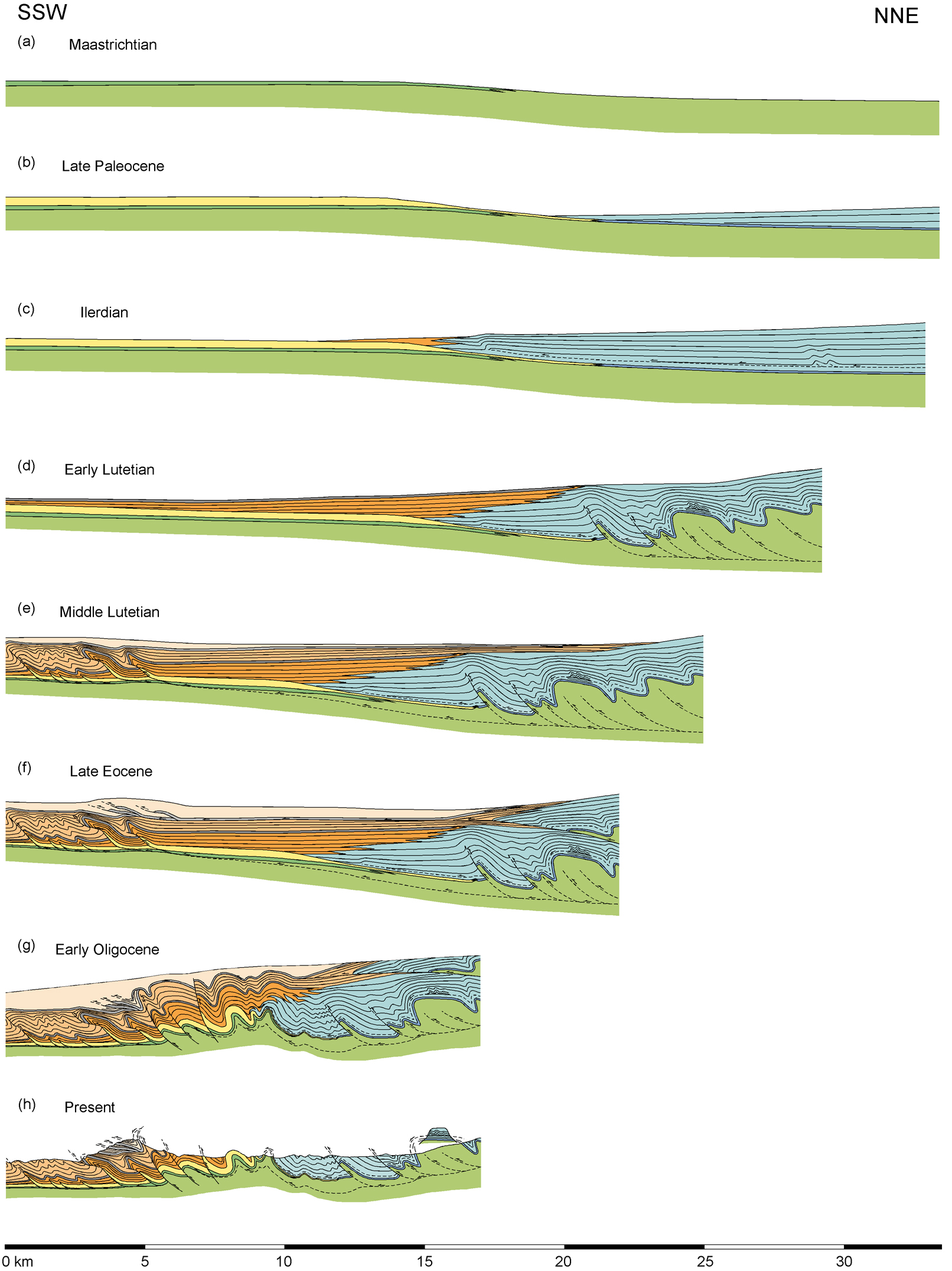
Figure 16. Schematic structural and sedimentological evolution of the Belagua-Minchale valley area, southwest central Pyrenees. The stratigraphic record in this area dates from Campanian-Maastrichtian to Late Lutetian. Deformation started somewhere in the Paleocene (c) (first activity of the Lakhoura thrust) and ended in the Early Oligocene (g) (Gavarnie thrust). For description of the individual figures see text. (Click for enlargement)
The total amount of shortening for this part of the Southern Pyrenees has been estimated at ~ 16.5 km. The total length of the present day section is some 17 km. Therefore the amount of shortening represents some 49% of the undeformed length of the section, which would have an original length of ~ 33.5 km. The total amount of shortening can be subdivided into three components, related to the Lakhoura, Larra and Gavarnie thrusts. The Lakhoura thrust (D1a, D1c) accounts for ~ 3.5 km of the total amount of shortening. This estimate has mainly been based on the minimum amount of displacement of the Ardibidipicua I, II and III thrusts (D1c). The Larra thrust (D1b) accounts for ~ 8.0 km of the total amount of shortening. The Urzainqui, Cacueta and Inzaga thrusts contribute to most of the shortening. The Gavarnie thrust (D2) accounts for ~ 5.0 km of the total amount of shortening. Main contributions to this total amount originate from the Arniota, San Zolo and Ezcaurri anticlines and the Ardibidipicua syncline.
The area of research shows a strong relation between sedimentation and tectonics with the development of a southward shifting foreland basin in the south bordered by south vergent thrust sheets in the north. The geological development of the area has been schematically plotted in

During Maastrichtian times (Fig. 16a), pelagic sediments were deposited in the north (Couche Rouge formation) while shallow marine sedimentation of sand and silt took place in the south (Marboré sandstone member). This was followed in the Paleocene (Fig. 16b) by the development of a carbonate platform in the south (Ager formation) on top of the Maastrichtian shallow marine sediments, while slope and deep marine (carbonaceous) turbiditic sedimentation took place to the north, prograding towards the south. During Ilerdian times (Early Eocene) (Fig. 16c), southward thrusting of the Lakhoura thrust (D1a) led to the initiation of emergence of the thrust belt in the north, drowning of the carbonate platform in the south and continuing sedimentation of turbidites towards the south. In the Early Lutetian (earliest Middle Eocene) (Fig. 16d), thrusting activity of the Larra thrust (D1b) led to further emergence of the thrust belt in the north and continuing southward shifting of the foreland basin with deposition of more siliceous turbiditic deposits. During Middle Lutetian times (middle Middle Eocene) (Fig. 16e), continued development of thrust sheets successively towards the south led to a shift in the depocentre south of the Urzainqui thrust with sedimentation of the turbidites of the Roncal formation. When the thrusting activity the Larra thrust nearly ceased, deposition of the second megabed (Ardibidipicua formation) took place. Reactivation of the Lakhoura thrust (D1c) in the Late Eocene (Fig. 16f) led to the formation of the Ardibidipicua thrusts and further increase of topography in the hinterland. Finally, during the Early Oligocene (Fig. 16g), activation of the Gavarnie thrust (D2) resulted in folding and steep reverse faulting in the central part of the area. Also, the northern part of the section was tilted towards the south, resulting from the formation of the axial zone antiform. Sub-aerial exposure followed, which led to erosion of the area (Fig. 16h).