The Pyrenees are a mountain belt of Alpine age, situated at the boundary between the Iberian and European plates, and form the westernmost extension of the Alpine-Himalayan chain. They extend from the Cantabrian platform in the west to the Provence in the east and are about 1500 km long with an average width of about 200 km. The Pyrenees formed due to collision of the European and the Iberian plates. This has been realised by the partial subduction of the Iberian plate underneath the European plate [Choukroune et al. 1990], which has been documented by seismic reflection data [ECORS Pyrenees team, 1988], seismic tomography [Souriau and Granet, 1995] and magnetotellurics [Ledo et al., 2000]. Deformation took place from the Late Cretaceous until the Miocene. The area of research is located in the western Central Pyrenees, some 15 km west of the termination of the axial zone. It is located in the Belagua and Minchale valleys, just south of the French border. The valleys strike ~ NNE-SSW, approximately perpendicular to the axis of the orogen. Detailed structural and sedimentological fieldwork has been conducted [e.g. Schellart, 1998] to unravel the local tectono-sedimentary history of the region. The most important results of this research are presented in this paper.
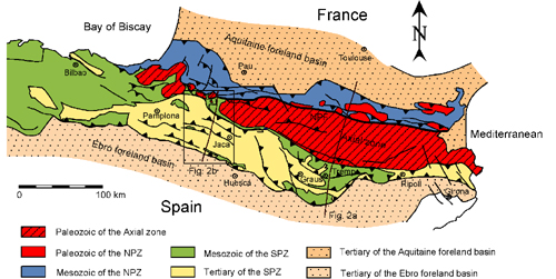
The Pyrenees have a fan like geometry, with north verging thrusts in the north and south verging thrusts in the south. The Pyrenees are generally divided into 5 structural zones [Vergés et al., 1995], which are, from north to south (Fig. 1):
Figure 1. Location map of the Pyrenees
Location map of the Pyrenees (modified from Teixell [1996, 1998]), showing the five structural zones of the Pyrenees. The location of two cross-sections has been plotted (see Fig. 2). The outlined area can be seen enlarged in Fig. 3. NPF, North Pyrenean Fault; NPZ, North Pyrenean Zone; SPZ, South Pyrenean Zone.
The Aquitaine molassic foreland basin which is a foreland basin, situated on the European plate. It formed by flexing under the weight of the thrusts of the North Pyrenean thrust zone, which were thrust on top of the plate from the south. The basin has been filled with tectonically undisturbed synorogenic sediments. The oldest sediments date from the Late Cretaceous.
The North Pyrenean thrust zone which is a zone of imbricate north verging thrusts. The thrusts affected the Hercynian basement and the Mesozoic to Late Eocene cover sediments. This zone is bounded to the south by a narrow zone of 1-5 km in width, the North Pyrenean zone [Choukroune, 1976], which consists of highly metamorphosed rocks of HT/LP origin [Goldberg, 1987].
The axial zone which consists of Hercynian rocks and forms a south vergent antiformal stack of basement thrust sheets. The thrust sheets show typical characteristics of thick-skinned tectonics. Occasionally, the thrust sheets are covered by small remnants of Mesozoic sediments. The axial zone consists of three major thrust sheets, which are, from bottom to top, the Nogueres, Orri and Rialph thrust sheet, respectively, in the central and eastern Pyrenees. In the western part of the central Pyrenees these are the Lakhoura, Gavarnie and the Guarga thrust sheet. The rocks in the axial zone have not experienced major Alpine metamorphism.
The South Pyrenean thrust zone, which is a zone of south vergent thrusts. It deformed by thin-skinned tectonics [Muñoz et al., 1986] with a décollement level in the Triassic evaporites overlying the undeformed Hercynian basement. The décollement zone emerges at the South Pyrenean Frontal Thrust (Sierras Marginales), north of the mainly undeformed Ebro molassic foreland basin. The zone includes the deformed Paleogene foredeep (Jaca basin). Deformation of the South Pyrenean thrust zone commenced in the Early Eocene and continued throughout the Tertiary until the Early Miocene [Labaume et al., 1985].
The Ebro molassic foreland basin which formed by flexing of the Iberian lithosphere under the weight of the South Pyrenean thrust system. The Ebro basin is a molassic foreland basin, with relatively tectonically undisturbed sediments of Tertiary age, which rest directly on top of the Hercynian basement.
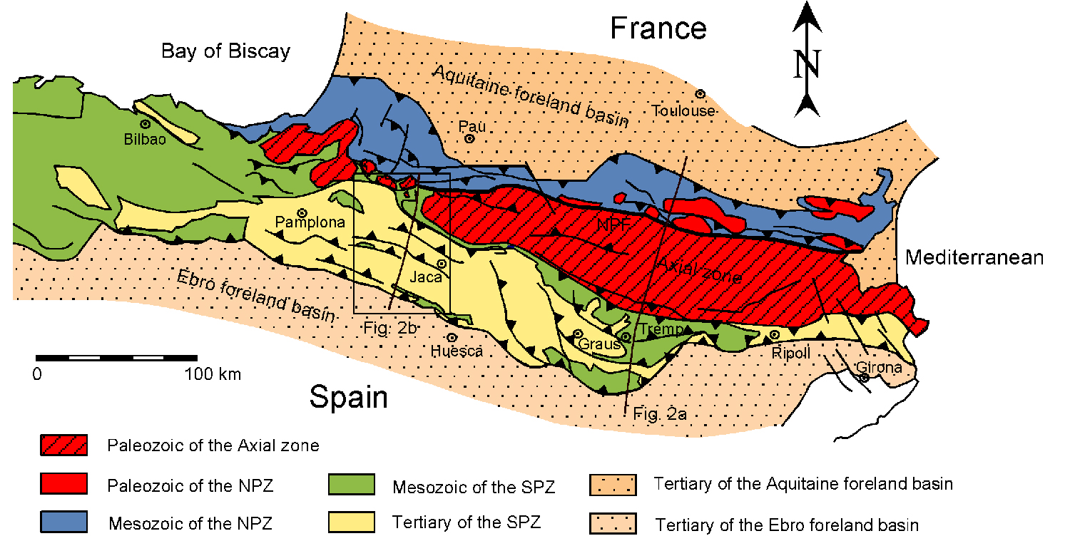
Figure 2. Cross-sections
(a) Crustal scale cross-section based on the ECORS-Pyrenees seismic profile (simplified from Munoz [1992]). See Fig. 1 for location. (b) Balanced cross-section through the western central Pyrenees from the southern margin of the North Pyrenean zone to the Ebro Basin (simplified from Teixell [1996]). See Fig. 1 and 3 for location. Note different scale between (a) and (b).
Total shortening in the Pyrenees (calculated from balanced and restored cross-sections) is estimated between 120 km [Roure et al., 1989], 147 km [Muñoz, 1992] and 165 km [Fitzgerald et al., 1999]. These estimates are mainly based on the restoration of the ECORS-Pyrenees deep reflection seismic survey [ECORS Pyrenees team, 1988, see Fig. 2a]. An estimated 125 km of shortening has been proposed by Vergés et al. [1995] for a cross-section, some 50 km to the east of the ECORS cross-section. They account 70 km of shortening to the South Pyrenean zone, ~ 23 km of shortening to the internal deformation within the basement units and ~ 32 km of shortening to the North Pyrenean zone. The difference in shortening between the north and south is probably related to the asymmetrical root of the Pyrenees, where the Iberian plate has been partially subducted underneath the European plate. The estimates mentioned above have been proposed for the central and eastern Pyrenees. However, in the western part of the central Pyrenees (some 150 km to the west of the ECORS section) total shortening is estimated to be in the order of 75-80 km (Teixell [1998]), based on mapping in the Southern Pyrenees (Anso transect [Teixell, 1996], see Fig. 2b and Fig. 3) and seismic reflection experiments in the Northern Pyrenees [Daignières et al., 1994]. This difference is the result of the greater amount of convergence between Iberia and Europe in the east compared to the west, related to the asymmetrical opening of the Bay of Biscay. This resulted in the formation of the antiformal stack of the basement thrust sheets in the east (Fig. 2a), but hinterland dipping basement duplexes in the west (Fig. 2b, 4).
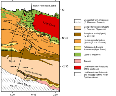
Figure 3. Simplified geological map
Simplified geological map of the area around the western termination of the axial zone. The traces of two cross-sections have been plotted. The eastern one is from Teixell [1996] (see Fig. 2b) and the western one is from Labaume et al. [1985] (see Fig. 4) The study area described in this paper has been outlined by a dashed line (see Fig. 5).
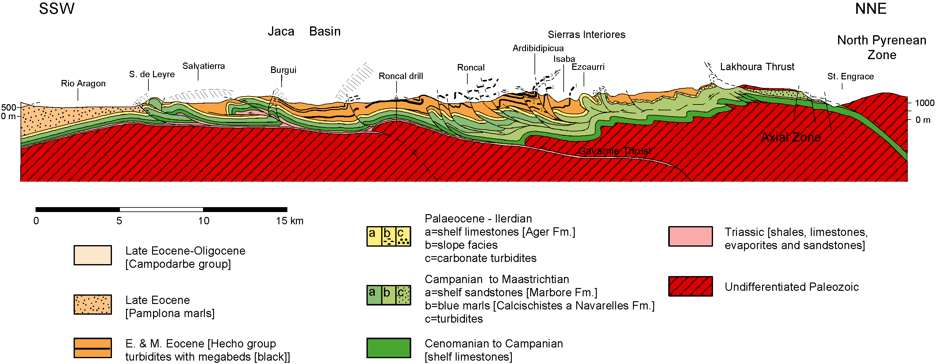
Figure 4. Cross-section running through the Belagua valley and the Roncal valley

Cross-section running through the Belagua valley and the Roncal valley. Redrawn after Labaume et al. [1985]. Location of cross-section can be seen in Fig. 3. The section shows two basement faults (Lakhoura thrust and the Gavarnie thrust). From the section it is evident that in the area between Roncal and the Spanish-French border most thrusts splay of a detachment level present in the marls of Campanian to Maastrichtian age. However, several thrusts near the summit the Ardibidipicua are related to another detachment level, which is probably related to the Lakhoura thrust.
The oldest rocks exposed in the Pyrenees form the Hercynian basement and are exposed in the axial zone and in the North Pyrenean zone. The rocks date from Cambrian to Carboniferous age and have been affected by low- to high-grade metamorphism during the Hercynian orogeny [Vissers, 1992] in the Late Carboniferous.
During early Permian times, a first stage of sinistral strike-slip was followed by progressive extension, which led to volcanism and intrusions of granitic bodies into the Hercynian basement [Zwart, 1979]. Deposition of postorogenic Permian redbeds occurred in small asymmetric fault bound basins as erosional products of the emerged mountains. During Triassic times, sediments were deposited in an intracontinental rift environment, with deposition of clastics, carbonates and evaporites [Puigdefàbregas and Souquet, 1986]. During Jurassic times, a widespread carbonate platform extended over most of the Pyrenees and surrounding areas [Peybernes and Souquet, 1984]. During Early Cretaceous times (Neocomian - Baremian), opening of the Central Atlantic Ocean caused a left lateral, transtensional movement of the Iberian plate with respect to the European plate, resulting in the opening of the Bay of Biscay and formation of pull-apart basins in the North Pyrenean zone [Puigdefàbregas and Souquet, 1986]. Sedimentation during this time was discontinuous and erosion was present. Marine sedimentation was restricted to these pull-apart basins. When transtension changed in left lateral strike-slip during Middle Albian to Early Cenomanian times, smaller scale lozenge to triangular shaped basins started forming [Puigdefàbregas and Souquet, 1986]. These basins were filled by the first Pyrenean flysch and narrow carbonate platforms started forming. The tectonic setting changed to transpression during the following phase. During Cenomanian-Middle Santonian times, a global sea-level rise resulted in basin widening, which led to the retreat of the carbonate shelves, while carbonate turbidite sedimentation continued in the deeper parts of the basins [Peybernes and Souquet, 1984]. During Late Santonian-Maastrichtian times, a transpressional tectonic system was present. This resulted in down-faulting tectonics, causing a general unconformity and creation of retreating erosional margins in the beginning of this period. The deeper deposits consisted of debris and interfingering systems of fan siliciclastics turbidites [Van Hoorn, 1970], whereas shallow water carbonates were deposited on the basin edge. These sediments were followed by a shallowing upward sequence from turbidites to shales and marls (Couche Rouge) and finally non-marine redbeds in the south (Aren and Marboré sandstones) [Puigdefàbregas and Souquet, 1986]. These sediments were deposited during the first phases of folding. The sinistral displacement, which started in the Early Cretaceous, ended in the Maastrichtian and was in the order of ~ 400 km towards the SE [Le Pichon and Sibuet, 1971; Olivet et al., 1981].
During the transition from Mesozoic to Tertiary times, rearrangement of the Iberian and European plate configuration changed the geographic setting. The Mesozoic deep marine basins with corresponding northern and southern margins disappeared and were replaced by a northern and southern Tertiary foreland basin, with the emerging mountain chain in between. In the following section, the attention will be focused on the southern Pyrenees, because it is of main importance to the rest of the paper.
During the Paleocene, emergence of the inner part of the chain led to erosion and deposition of non-marine redbeds, which extended from the northeast to the east and all along the southern foreland from the east to the west near Pamplona. Along most of the southern Pyrenees a shallow carbonate shelf developed (Ager formation [Labaume et al., 1985]), including reef formations in the western Pyrenees. In the west, this shallow marine shelf environment changed northwards into a deeper basin, with deposition of carbonate slope facies and condensed deeper hemipelagics and carbonate turbidites [Léon-Gonzalez, 1972; Plaziat, 1975]. During this period, the first foreland basin geometry established in the east, while Mesozoic type basins still prevailed in the west.
From Eocene-Early Oligocene times, the Pyrenees developed into a real fold and thrust belt orogen [Seguret, 1972]. Successive thrust sheets formed in a piggyback sequence. During this period a complete southern foreland basin developed, which was flanked in the north by active thrust sheets and in the south by platform carbonates [Puigdefàbregas and Souquet, 1986; Barnolas et al., 1991]. A siliciclastic turbiditic trough developed in the east (Vic Basin) and in the west (Jaca Basin), while in the centre deltaic fan deposition took place (Tremp-Graus basin) (Fig. 1). During ongoing deformation and southward propagation of the active thrust sheets of the southern Pyrenees, the southern foreland basin synchronously shifted southwards, with turbiditic deposits onlapping onto the retreating southern platform carbonates [Labaume et al., 1985]. Contemporaneously, the southern foreland basin shifted westwards, due to progressive infilling of the basin from east to west. During Bartonian times, final infilling of the Jaca and Vic basins resulted from delta progradation from the active northern margin. These sediments were covered by a deltaic system prograding westward. The Tremp-Graus basin was at this time a region of erosion or non-marine sedimentation. The extensive southern carbonate platforms were no longer present during this time.
During the Oligocene, sedimentation was mainly fluvial to the south of the progressively emerging axial zone [Puigdefàbregas, 1975]. Southward migration of the basin and the deformation front continued during this period and ended during the earliest Miocene [Teixell, 1996]. Lower Miocene molasses were deposited unconformably above thrusts and folds of the southern Pyrenees deformation front and were later gently folded [Labaume et al., 1985]. From this time onwards the sedimentation shifted to the autochthonous Ebro basin.