Regional analysis of the structural architecture, the distribution and thickness of syn- and post-rift sequences, and the location of major magmatic provinces has revealed a pronounced discrepancy between the location of maximum crustal extension, syn-extensional magmatic provinces, and the location of the maximum post-rift subsidence. These spatial association along with the shift in the basin depocentre after rifting, suggests the locus of crustal stretching (given by a stretching factor of ß1) was offset from the locus of sub-crustal lithospheric thinning (ß2), suggesting an asymmetric lithospheric extension (Coward, 1986; Lister et al., 1991).
Crustal extension was widespread across the entire Western Fold Belt (Betts et al., 1998). Variations in fault geometry across the Western Fold Belt are interpreted as to be caused by differences the preexisting basement architecture (Betts et al., 1998; 1999). The N-S and E-W faults were reactivated during NW-SE directed extension (Betts et al., 1998). The architecture in the northern terrane resulted from orthogonal extension where normal faults developed perpendicular in the bulk extension direction. The following observations suggest that the Mount Isa Rift Event underwent asymmetric lithospheric extension during the Mount Isa Rift Event:
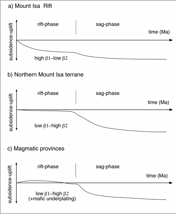
The Mount Isa Rift is characterised by a relatively high ß1 and a low ß2 (Betts et al., 1998)
The absence of magmatic rocks throughout the Mount Isa Rift indicates that a heat source associated with an upwelling asthenosphere and/or mafic underplating was relatively insignificant, and that stretching of the sub-crustal lithosphere was minor (Figure 5a and b) (Betts et al., 1998). Tectonic subsidence associated with a crustal thinning and the development of rotational tilt blocks was not counteracted by the thermal uplift, resulting in overall subsidence (Figure 6a). Up to ~3-5 km of syn-rift shallow marine to distal fluvial stratigraphy is preserved on the western part of the Mount Isa Rift.
Figure 5. Schematic cross section
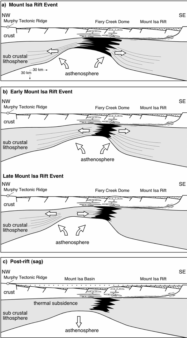
Schematic cross section depicting the asymmetric extension model. (a) The maximum upper crustal extension (b1) occurred along the Mount Isa Rift where the syn-rift stratigraphic pile is thickest. Major magmatic provinces are inferred to be located above significant sub crustal lithospheric extension (high b2), asthenosphere upwelling and underplating. The maximum sub crustal lithosphere stretching is inferred to occur to the northwest where the thickest accumulation post-rift sequences occur. (b) Initial sub crustal lithosphere extension focussed beneath the magmatic provinces. As the rift system evolved the focus of sub crustal lithosphere extension shifted northwest to where the maximum post-rift subsidence occurred. (c) Post-rift (sagphase) evolution of the Isa Superbasin. Dissipation of the thermal anomaly to the west of the Mount Isa Rift results in significant subsidence and the creation of accommodation space for accumulating post-rift sequences in the northern Mount Isa terrane. Subsidence along the Mount Isa Rift is limited.
Regions to the west of the Mount Isa Rift are characterised by low ß1 and a high ß2 (Betts et al., 1998). A thinner syn-rift sequences and evidence of prolonged periods of erosion and depositional hiatus of the western rift flanks suggest that it occupied a palaeogeographic high during the Mount Isa Rift Event (Betts et al., 1998; 1999). This palaeogeographic high is coincident with increased magmatic activity (Betts et al., 1998) The whole rock geochemistry of the Mount Isa Rift Event igneous rocks are interpreted to be A-type granitoids sourced from lower crustal melting (Wyborn et al., 1988). The mechanism for coincident lower crustal melting and the introduction of mantle derived material into the crust, was asthenospheric upwelling and mafic underplating associated with sub crustal lithospheric thinning (Betts et al., 1998). Uplift due to thermal expansion may have counteracted similar amounts of subsidence caused by crustal thinning (Figure 5a and b) (Lister et al., 1991; Coward, 1986), resulting in a relatively stable uplift/subsidence history (Figure 6c).
Figure 6. Typical uplift-subsidence histories
Typical uplift-subsidence histories for different parts of the MIRE rift system based on the asymmetric lithospheric extension model: (a) The Mount Isa Rift with a high ß1 and a low ß2. This uplift-subsidence history is characterised by syn-rift subsidence associated with thinning of the crust. Sag phase subsidence is limited compared with the northern Mount Isa terrane. (b) Inferred uplift-subsidence history for the northern Mount Isa terrane with a low ß1 and a high ß2. This part of the terrane remained relatively stable during the MIRE. After the cessation of rifting the subsidence was greatest where the thermal anomaly began to wane. (c) Uplift-subsidence history of the magmatic provinces. Rifting was accompanied by permanent uplift associated with underplating. The region became submerged during the waning stages of the MIRE. As a result of the underplating the post-rift subsidence is less than the regions to the northwest. Qualitative analysis of these histories is based on calculations by Lister et al., 1991.
Periods of minor uplift resulted in depositional hiatus and erosion. Relatively small component of subsidence produced less accommodation space for accumulating sediments. A shift in magmatic activity from the north to south suggests a migrating heat source. Accretion of large volumes of mafic material onto the lower lithosphere during underplating requires either unusually high potential temperature of the asthenosphere, or a significantly thinned lithosphere (Lister and Etheridge, 1989). Underplating usually occurs late in the extensional history (Lister and Etheridge, 1989). However, magmatism, occurred early in the rift history. This suggests that the sub- crustal lithosphere was stretching long before crustal extension began, or the lithosphere was already thin and partial melting occurred at normal asthenosphere temperatures (Lister and Etheridge, 1989; McKenzie, 1978). Such a thin lithosphere is probable because of the pre-existing extensional history.
The post-rift geometry of a sag-basin is strongly influenced by the position of sub-crustal lithospheric thinning (McKenzie, 1978; Coward, 1986; Lister et al., 1991). Thermal uplift may have continued after the Mount Isa Rift Event. Thinning of the Mount Isa Group and the lower McNamara Group towards the magmatic provinces may be recording permanent uplift beneath the rift flanks (cf. Figure 6b and c) (Betts et al., 1998; Lister and Etheridge, 1989). The northern Mount Isa terrane is characterised by a low ß1 and a high ß2 during the Mount Isa Rift Event (Betts et al., 1998) (Figure 6b).
Maximum post-rift subsidence occurred above the position of maximum sub-crustal lithospheric thinning (McKenzie, 1978; Coward, 1986; Lister et al., 1991) (Figure 5c and 6b) in the northern Mount Isa terrane where the post-rift stratigraphy is thickest and the depositional history is more protracted (~1653 Ma to ~1595 Ma: Page and Sweet, 1998) (cf Figure 5c and d). There is however, a disparity in the location of the thickest post-rift stratigraphy in the northern Mount Isa terrane and the position of magmatic provinces on the rift flanks. Two scenarios are considered:
Maximum sub-crustal lithospheric thinning occurred beneath the region of the maximum post-rift subsidence (Figure 5a). Granite emplacement and bimodal volcanism was coincident with lithospheric thinning and asthenospheric upwelling but mafic underplating was the significant contributor to lower crustal partial melting (Figure 5a).
Magmatic provinces and underplating were coincident with maximum sub crustal lithospheric thinning and asthenosphere upwelling during early rifting (Figure 5b). The focus of maximum sub-crustal lithospheric thinning shifted westward to the location of maximum post-rift subsidence (Figure 5b and c) as the rift system evolved (Betts et al., 1998).