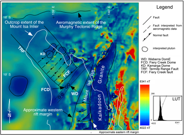
Magmatic activity within the Mount Isa Rift was minor with thin volcanic flows extruded along the eastern margin (Batson, 1991). Granitic plutons are not preserved at the surface, nor is there any geophysical evidence for their existence in the subsurface. In contrast, magmatic units are aerially extensive and form a ~N-S trending belt to the W and NW of the Mount Isa Rift. Volcanic and intrusive units formed during two discrete spatiotemporal magmatic episodes. Early magmatism (~1710 and 1700 Ma) in the northern Mount Isa terrane involved the development of domes during shallow level pluton emplacement (Figure 1) (Betts et al., 1998; 1999). The Fiery Creek and Kamarga Domes are truncated and overprinted by northeast striking normal faults, suggesting magmatism predated faulting. Domes are characterised by low potential field responses suggesting the presence of a shallow pluton in their subsurface (Figure 4).
Figure 4. Regional aeromagnetic data
Regional aeromagnetic data of the northern Mount Isa terrane and the northern Leichhardt River Fault Trough (Mount Isa Rift).
Interpreted MIRE aged plutons and major faults are shown. Flight line spacing: 1600 metres; flight height: 200 metres; inclination: -50º; declination:6º; magnetic field strength: 52000nT. This image is released with permission of the direction of the Australian Geological Survey Organisation.
The regional geophysical signature indicates that the volume of igneous rock is significantly greater than the surface expression. (Figure 4) (Betts et al., 1998). The bimodal Fiery Creek Volcanics were extruded into half graben. Extrusion of the mafic and felsic suites was contemporaneous (Betts et al., 1998). The felsic suite displays a highly variable thickness up to ~800 m, and mainly comprises banded and massive rhyolite flows next to the Fiery Creek Fault. Altered, massive and vesicular basalts (150 m thick) (Hutton and Wilson, 1984) are exposed over a larger area. The second phase of magmatism involved the emplacement of the Sybella Granite, and the Carters Bore Rhyolite to the west of the Mount Isa Fault system (Figure 1). U-Pb SHRIMP crystallisation ages for the Carters Bore Rhyolite (1678±2 Ma: Page and Sweet, 1998) and the Sybella Granite (~1670-1655 Ma: Connors and Page, 1995) constrain the timing of this event. The Sybella Granite comprises several alkali feldspar and granodiorite plutons (Connors and Page, 1995). The regional map pattern (Figure 1) suggests that magmatic rocks are more extensive in the south. This does not necessarily indicate a greater volume of igneous rock but may simply reflect deeper levels of erosion in this part of the terrane (Betts et al., 1998).