Geologic Setting
The Himalaya is made up of a simple series of tectonostratigraphic units that extend along much of the > 2000 km length of the mountain belt. While the basic tectonostratigraphic units may be widely recognized, the degree of variability within those units can fluctuate widely. For the purposes of this guide we will provide a broad overview of the Himalayan tectonostratigraphy, the structures that disrupt it, and the geology specific to the field trip area.
Geology of the Himalaya
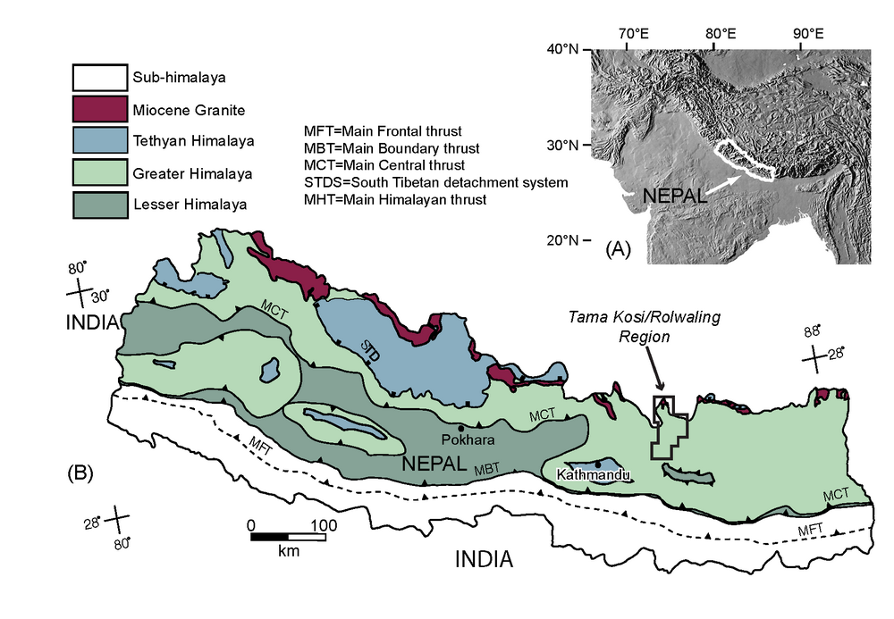
At the orogen scale the Himalaya is made up of four fault-bounded tectonostratigraphic domains (Figure 2). The rocks in these domains are remnants of the northern India continental margin sedimentary wedge that was detached from the Indian basement and deformed during continent-continent collision.
The northernmost domain is made up of unmetamorphosed-to-low-grade metasedimentary rocks (the Tethyan sedimentary sequence) (Yin, 2006) that are bounded to the north and separated from rocks of Eurasian affinity by the Indus-Tsangpo suture (Yin and Harrison, 2000). The Tethyan metasedimentary rocks are separated from the subjacent Greater Himalayan sequence to the south by the north-dipping South Tibetan detachment system. The Greater Himalayan sequence, also known as the Greater Himalayan crystallines or the Tibetan slab, is composed of upper greenschist to upper amphibolite facies paragneiss, orthogneiss, and leucogranite (e.g. Larson et al. 2010). The Greater Himalayan sequence is juxtaposed against the underlying Lesser Himalayan sequence along the north-dipping Main Central thrust (Heim and Gansser, 1939). The Lesser Himalayan sequence (sometimes referred to as the Midlands Group or, in part, as the Lesser Himalayan crystallines) is dominantly composed of an unmetamorphosed-to-low grade sedimentary succession with intercalated augen orthogneiss. The Lesser Himalayan sequence is bounded below by the north-dipping Main Boundary thrust that places the Lesser Himalayan sequence atop the Siwalks (Yin and Harrison, 2000), the unmetamorphosed foreland deposits of the Himalayan orogen that have now been incorporated into its deforming foreland wedge. The Siwaliks are preserved in the hanging wall of the Main Frontal thrust at the leading edge of the Himalayan thrust system.
Figure 2. Geologic map of the Nepalese Himalaya
General geologic map of the Nepalese Himalaya. Geology modified from Martin et al. (2005); figure modified from Larson (2012). The location of the field trip area (Figures 1 and 3) is indicated
The main bounding faults of the Himalaya are all north dipping. The Main Central, Main Boundary, and Main Frontal thrusts (Figure 2) are all thrust sense structures that record top-to-the-south sense translation and young from north (Main Central thrust) to south (Main Frontal thrust). The South Tibetan detachment system, however, typically records the opposite sense of shear, top-to-the-north, and is a normal-sense stretching fault in the sense of Means (1989). The timing of movement on the South Tibetan detachment system varies both along the Himalayan orogen (Godin et al., 2006 and references therein; Kellett et al., 2013) and across related transverse structures (e.g. Kellett et al., 2009). Motion on the detachment system, however, is largely accepted to have occurred between the Early and Middle Miocene (Godin et al., 2006). This overlaps with estimates for timing of movement across the Main Central thrust, and implies that the Greater Himalayan sequence, which is bound above and below by these normal and reverse-sense faults, respectively, was extruded laterally southward during coeval movement on the two fault systems (Godin et al., 2006).
While the basic structure of the Himalaya and the tectonostratigraphic units therein are typically described in relatively simplistic terms, there is significant disagreement in how the Main Central thrust, and therefore the Greater Himalayan sequence and Lesser Himalayan sequence it juxtaposes, should be defined and identified (e.g. Martin et al., 2005; Searle et al., 2008; Larson and Godin, 2009). No broad consensus on precisely how the Main Central thrust is recognized across the Himalaya has emerged. For the purposes of this field trip we avoid distinction between the Lesser Himalayan sequence and Greater Himalayan sequence, but instead consider all rocks that record a Cenozoic metamorphic, deformational, and thermal history as parts of the Himalayan metamorphic core in the hanging wall of the Main Central thrust. Mapping the Main Central thrust at the base of Cenozoic deformation, metamorphism and thermal influence in this manner is broadly consistent with the interpretation of Searle et al. (2008). When using this field guide or comparing any investigations of the Main Central thrust the reader should be aware of how this key structure is defined in each case.
Research in the Tama Kosi and Rolwaling region
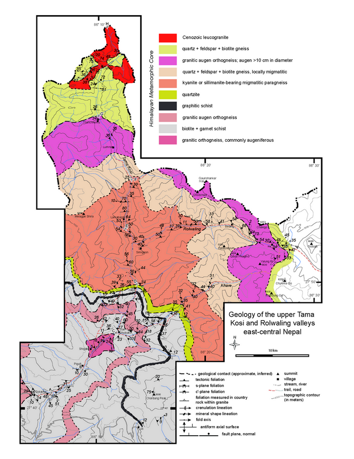
The Tama Kosi and Rolwaling region was first mapped at a reconnaissance scale as part of a broader mapping campaign of east-central Nepal by T. Ishida in the 1960’s. Ishida eventually published two papers that included information on the geology of the region (Ishida, 1969; Ishida and Ohta, 1973). These early contributions demonstrated that all of the rocks in the region have been metamorphosed and that the general metamorphic grade increases up structural section towards the north. A later regional study by Schelling (1992), which included parts of the present study area, expanded on the initial work of Ishida and reinterpreted the rocks in terms of the contemporary organization of Himalayan geology outlined above. Schelling (1992) mapped the Main Central thrust as occurring in the middle of the present field guide area near the town of Jagat (Figures 1 and 3). This interpretation placed Greater Himalayan sequence rocks to the north of Jagat and Lesser Himalayan sequence rocks to the south.
Figure 3. Geology of the Tama Kosi/Rolwaling
Geology of the Tama Kosi/Rolwaling region. Map location shown in Figure 2. Modified from Larson (2012)
Larson (2012) published the first detailed field lithotectonic, structural, and petrologic descriptions for the area. Based on these new observations and the Searle et al. (2008) definition of the Main Central thrust, Larson (2012) mapped the fault structurally below, or south of, the present field guide region. This study was followed up by a more detailed, laboratory-based study linking metamorphic conditions to time via microstructures and variations in trace elements of dated monazite across the region (Larson et al., 2013). The study indicated the presence of a structural, metamorphic, and geochronologic discontinuity within the exhumed metamorphic rocks of the area. This discontinuity represents a tectonic juxtaposition of hanging wall rocks (metamorphosed and deformed while part of a laterally translated midcrustal layer that moved out from the orogenic hinterland) against footwall rocks that never extended in to the orogenic hinterland, but were deformed and metamorphosed during their incorporation into an evolving wedge taper along the foreland of the Himalayan orogen (Larson et al., 2013).
Lithologies
The rocks exposed in the Tama Kosi and Rolwaling valleys include a wide range of lithologies of various metamorphic grades and local anatexite content (Larson, 2012). The rocks are dominantly metasedimentary but are intercalated with meta-igneous rocks at multiple structural levels (Figure 3). Both metamorphic grade and general volume of anatexite increase up structural section, from south towards the north. The structurally lowest rocks, in the south, are at garnet-biotite grade followed by staurolite grade, kyanite grade, and finally sillimanite grade traced up structural section (Figure 4). Anatexite at the structurally lowest levels is only locally present, and where observed comprises less than 5% of the rock by volume. The total anatexite volume is relatively low south of the village of Jagat. Just north of Jagat, anatexite comprises a significant portion of the rock volume (20-30%), while the structurally highest rocks are migmatitic and show evidence for multiple melt generating events. At sillimanite grade the rocks comprise up to 50-60% anatexite (Larson, 2012).
Figure 4. Geological section across the Tama Kosi/Rolwaling region
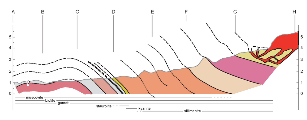
Generalized vertical geological section drawn across the Tama Kosi/Rolwaling region. The line of section is outlined by letters A through H on Figure 3. Modified from Larson (2012)