Geological setting
Roma and its hinterland are part of a portion of the western coast of Central Italy between the Apennine chain and the Tyrrhenian sea (Fig. 2). The Apennine chain is a complex structural unit thrusting toward E and NE mainly between Upper Miocene and Lower Pliocene (Mattei et al., 2008 and references therein). The inner side of the chain has progressively been extended westward to form the back-arc Tyrrhenian basin, whereaside, from Tuscany to Sicily, a complex volcanic belt, mostly K-rich in composition, developed from Lower Pleistocene to Present (e.g. Barberi et al., 1994; Conticelli et al., 2002; Mattei et al., 2010 and references therein).
The open and planar landscape of the Campagna Romana is mainly related to its Quaternary tectonic and volcanic evolution. During Lower Pleistocene the coast attained approximately its present configuration with the regression from open marine to continental environments (Funiciello and Giordano, 2008a,b; Parotto, 2008). Since the Middle Pleistocene, four main volcanic districts have been active along the Tyrrhenian margin between Tuscany and Latium, which are from north to south the Vulsinian Latera and Bolsena calderas, the Vico stratovolcano, the Sabatinian Bracciano and Sacrofano calderas and the Colli Albani caldera complex. These volcanoes erupted thousands of cubic kilometres of magma and emplaced large volume ignimbrite sheets confering to the region its gentle morphology (e.g. Giordano et al., 2006, 2010). The ignimbrite plateau has been deeply eroded during the last glacial age by the Tiber river fluvial network and delta. During the subsequent rise of the sea level, the fluvial network has been backfilled with alluvial Holocene deposits, consisting of unconsolidated clayey-sandy sediments.
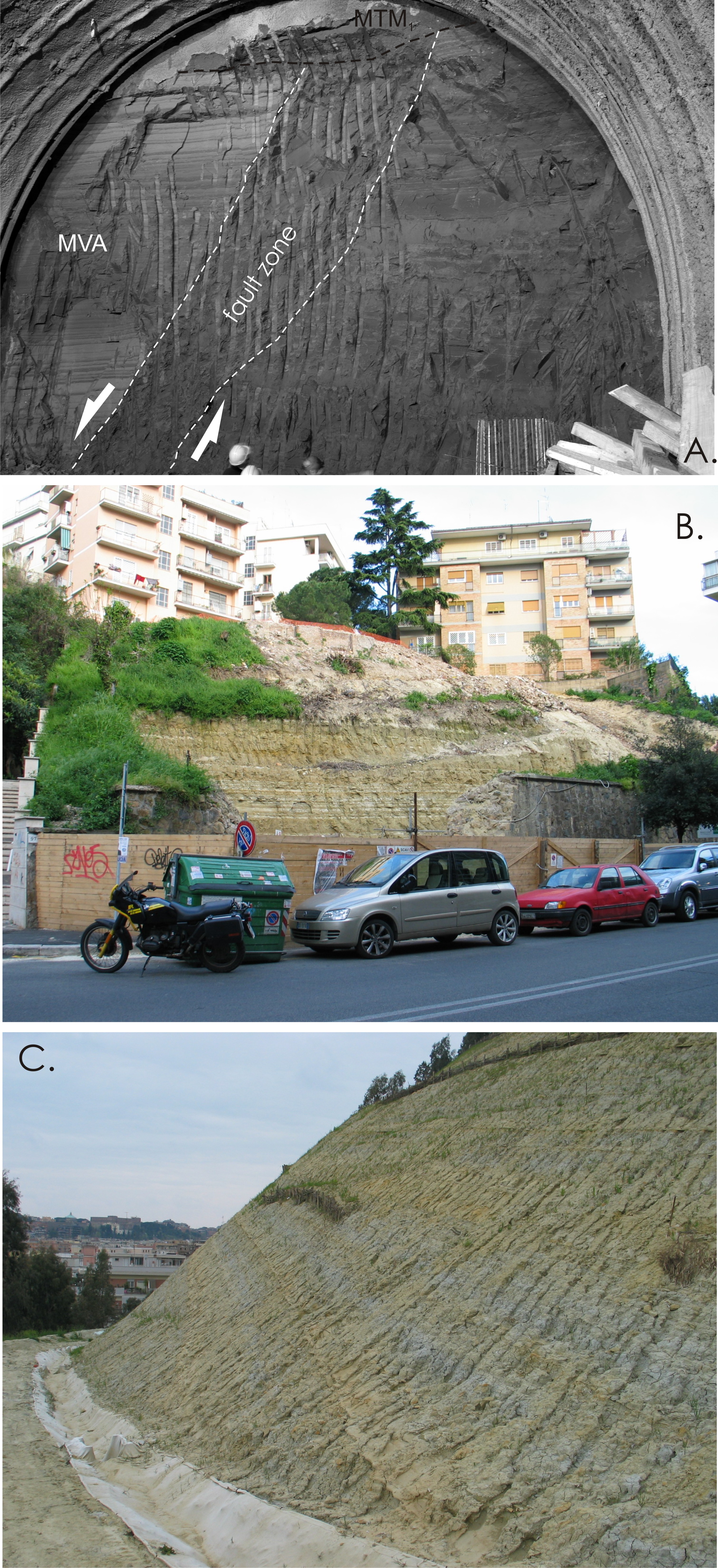
Figure 3. The bedrock of Roma
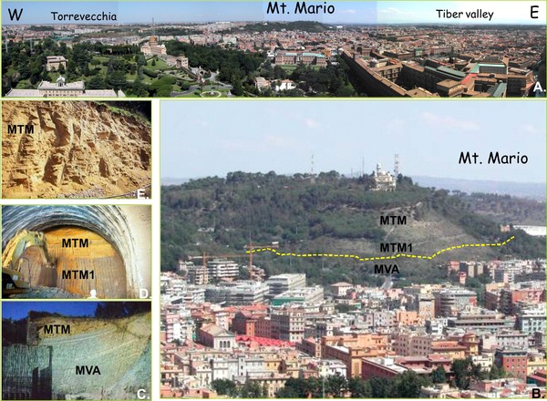
A. Panoramic view of Monte Mario viewed from the summit of S. Pietro basilica; B. Close up showing the reconstructed unconformity which separated the Pliocene Monte Vaticano Fm. (circalittoral grey clays; MVA) from the overlying Lower Pleistocene Monte Mario Fm. (infralittoral to transitional yellow and grey sand; MTM), here underlined by the Farneto member (infralittoral grey silt and sand, MTM1); C. The same contact as it could be seen at Fornace Veschi, near Valle Aurelia (now covered by back-fill); D. Stratigraphic conformable contact between the Farneto member and the yellow sands of the Monte Mario Fm. during the excavation of the Galleria Giovanni XXIII; E. Typical cross stratified and unconsolidated appearance of the yellow sands of the Monte Mario Fm.
The deep structure of the Campagna Romana is constituted by extensional highs and lows mainly overprinting pre-existing NW-SE thrusts, which piled up the Mesozoic-Cainozoic carbonatic and terrigenous succession during the Apennine orogeny (Funiciello and Parotto, 1978; Mattei et al., 2008; Danese and Mattei, 2010).
The pre-orogenic Mesozoic-Cainozoic sedimentary succession is composed by limestones and marls deposited in the Tuscan and Sabinian basins of the Thetys sea, overlain by an allochtonous terrigenous cover, the “Ligure flysch”, emplaced gravitationally during the early phases of the orogeny. This succession is structurally organized in a sequence of ramps and flats and it has been encountered in several deep bore-holes in correspondence with structural highs at variable depths from a minimum of few hundreds of meters below surface (Cristoforo Colombo GRA) to more than 1300 m below surface (Cesano, Circo Massimo) (Funiciello and Parotto, 1978; Barberi et al., 1994; Funiciello and Giordano, 2008a,b).
Figure 4. The volcanoes of Roma
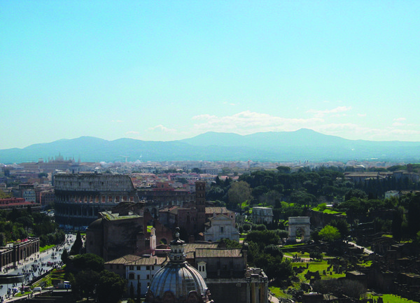
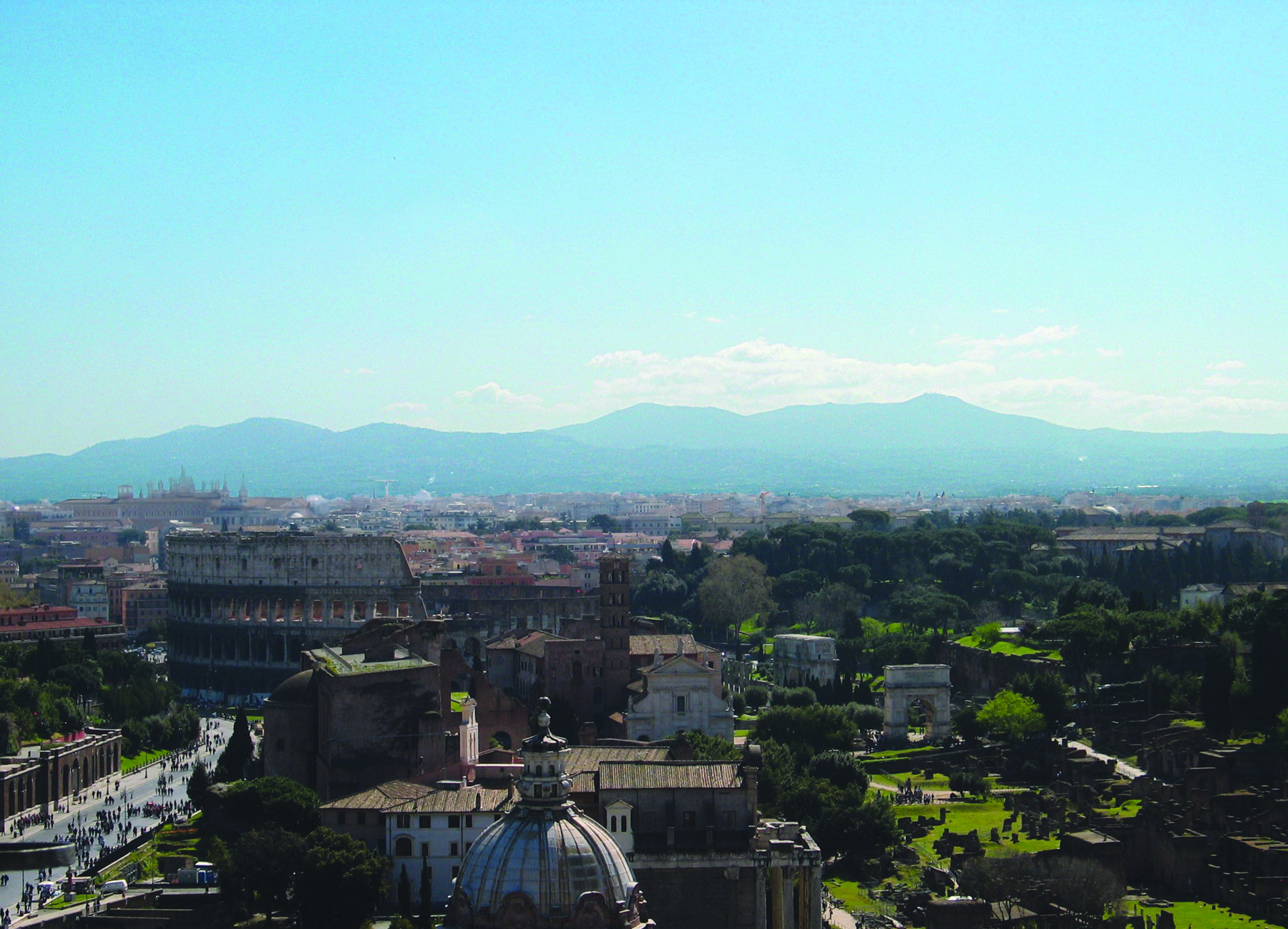
A. The Colli Albani volcano profile seen from the Capitolium hill with the Coliseum and the Forum in the foreground

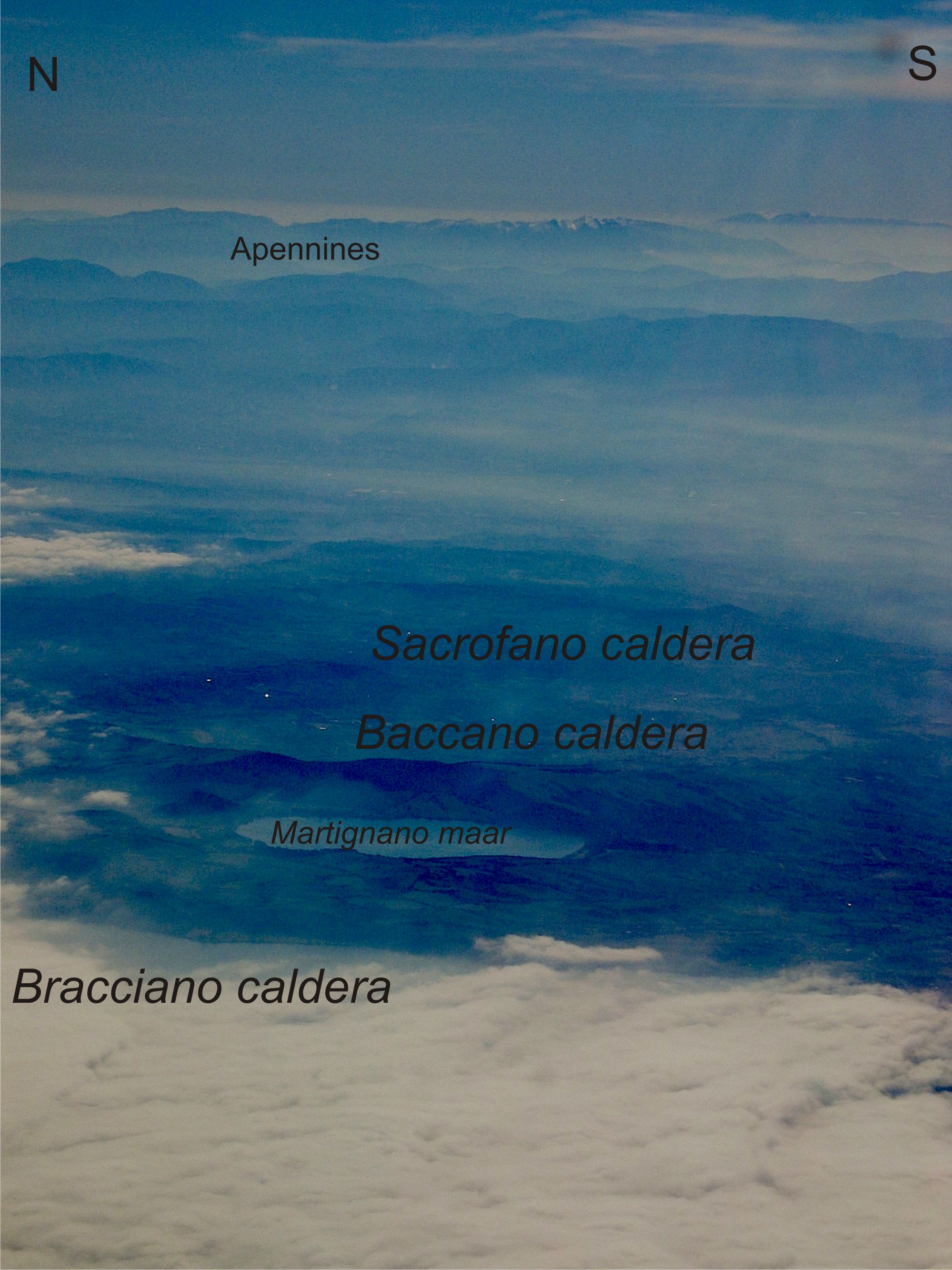
B.. The Sabatini calderas seen from the airplane, landing at Fiumicino airport. The Bracciano caldera in the foreground is largely covered by clouds, then toward the east we see the Martignano maar lake, then the Baccano caldera and the Sacrofano caldera. In the background the Apennine Mountains.
The post-orogenic terrigenous marine sedimentation along the Tyrrhenian margin started diachronously during the Messinian-Lower Pliocene overlying the deformed Mesozoic-Cainozoic basement. The pre- and syn-depositional development of structural highs and lows, together with the isostatic rebound of the Tyrrhenian margin accompaining the transition from the orogenic to the post-orogenic phases, determined different sedimentary basins, mostly NW-oriented (e.g. Barberi et al., 1994; Buonasorte et al., 1991).
The post-orogenic stratigraphic succession outcrops discontinuously along the margins of the Apennine chain, in correspondence of structural highs and of shallow intrusions of magmatic bodies. Roma is located along one of the NW-trending structural highs, the Monte Mario high (Fig. 3), where the Pliocene-Pleistocene sedimentary succession shows the transition from open marine (grey clay and yellow sand) to continental facies (fluvial-deltaic conglomerate and sand).
After the Brunhes-Matuyana reversal, approximately at 780 ka, the Sabatini volcano and the Colli Albani volcano (Figs. 2 and 4a,b), respectively to the NW and to the SE of Roma, started their activity, which lasted till the Upper Pleistocene for the Sabatini and till the Holocene for the Colli Albani from the eccentric Albano maar (Funiciello et al., 2003; Giordano et al., 2006, 2010; De Benedetti et al., 2008, Anzidei et al., 2008). During this time span, the interplay between volcanism, tectonism and climate changes has produced the alternation of depositional and erosive phases, recorded by the complex arrangement of the Middle-Upper Pleistocene fluvial terraces along the course of the Tiber river.
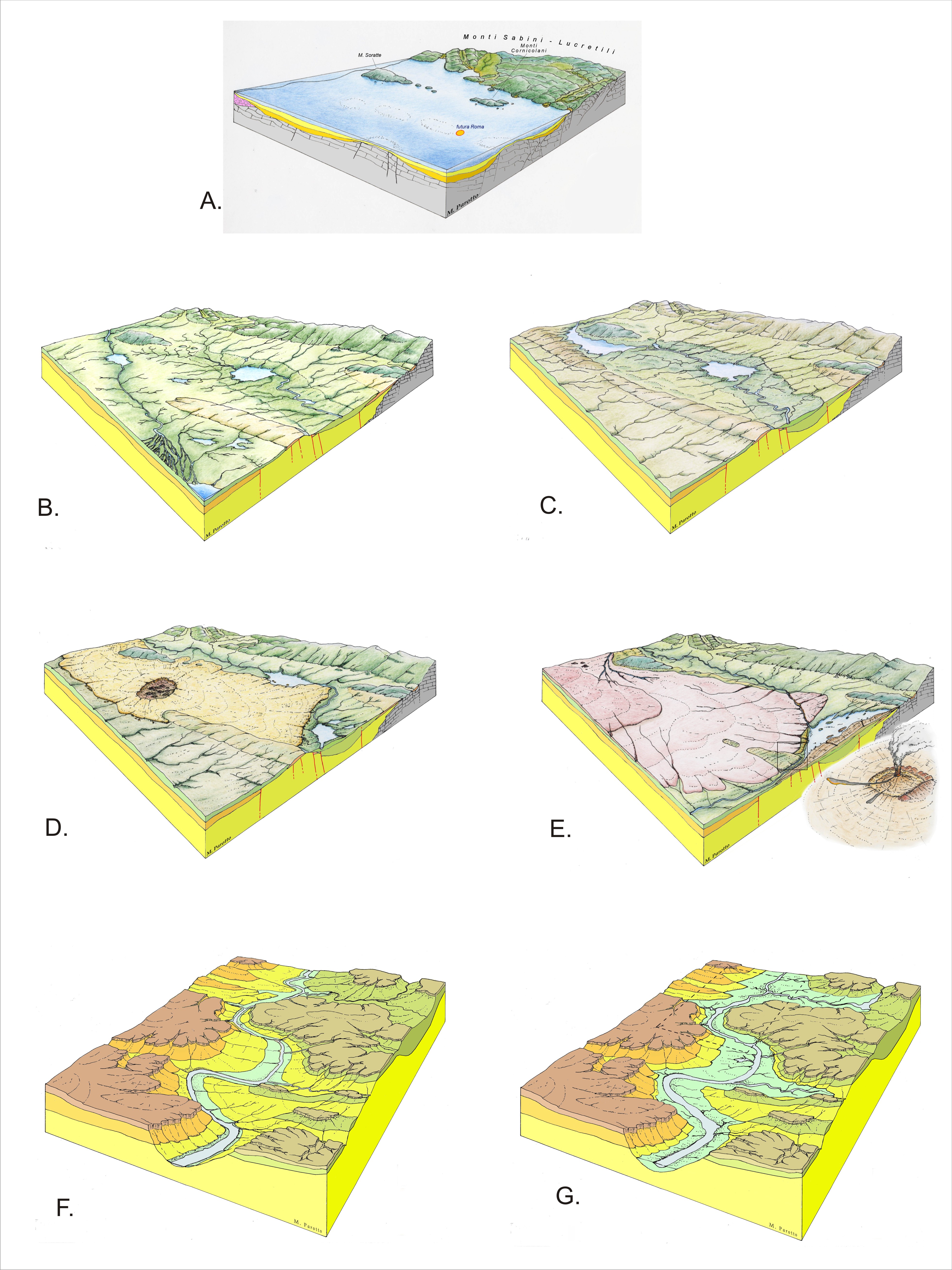
The sequence of block diagrams of Fig. 5 illustrates the paleogeographic evolution of the Campagna Romana since Pliocene.
Figure 5. Paleogeographic Evolution of the Roman area (from Parotto, 2008)

A. Pliocene (post-orogenic deep marine sedimentation); B. Lower-Middle Pleistocene (marine regression and paleo-Tiber river delta formation); C. Middle Pleistocene (Monte Mario horst uplift); D. Middle Pleistocene (formation of the ignimbrite plateau of the Sabatini volcanic district); E. Middle Pleistocene (formation of the ignimbrite plateau of the Colli Albani volcanic district; the small black box indicates the area illustrated in the next two block-diagrams); F. Upper Pleistocene (incision of the last glacial age fluvial network); G. Holocene (formation of the alluvial plains).
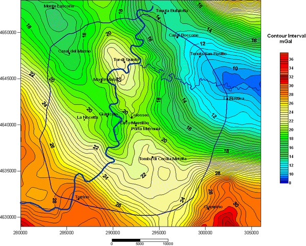
Figure 6. Map of the Bouguer anomalies of Roma (from Cesi et al., 2008)
Some localities are indicated for geographic reference, as well as the trace of the Tiber river and the outer-ring GRA freeway.
Pliocene (Fig. 5a) - The area corresponding with the future Campagna Romana was submerged by the Tyrrhenian sea and formed an articulated continental platform from which isolated blocks emerged to form islands (Monte Soratte and Monti Cornicolani). The marine open-marine shales were deposited during the Pliocene, presently form the hundreds of meters thick bedrock of the area with very low permeability and over-consolidated characteristics (Capelli and Mazza, 2005; Cosentino et al., 2008). These shales are named Monte Vaticano Fm. (MVA; Funiciello and Giordano, 2008a,b). At the transition Upper Pliocene-Lower Pleistocene, an episode of tectonic uplift occurred favouring a temporary emersion of structural highs, and namely of the Monte Mario high (Fig. 6) (Cesi et al., 2008), where the Monte Vaticano Fm. is eroded at the top by a planar erosional surface (Fig. 7) (Cosentino et al., 2009).
Lower Pleistocene (Santernian-Aemilian) (Fig. 5b). After the episode of tectonic uplift and emersion, the Roman area was again submerged. The Pliocene Monte Vaticano Fm. is overlain, above a subhorizontal erosional unconformity, by Lower Pleistocene (Santernian) infralittoral sandstone and siltstone which form the Monte Mario Fm. (MTM) (Figs. 7 and 8). These rocks culminate along the NW-trending Monte Mario structural high and mostly outcrop along the right bank of the Tiber river valley (Fig. 3).
Figure 7. The Pliocene Monte Vaticano Formation

A. The unconformity between the Pliocene marine clays (MAV) and the Lower Pleistocene silts and sands (MTM) exposed during the excavation of the Galleria Giovanni XXIII through Mt. Mario. Note the tectonic deformation sealed by MTM; B. The MAV clays and sand crop out along the Mt. Mario slopes, seldom causing landslides (Via Labriola); C. Excavation of the MAV clays at Via di Donna Olimpia for the construction of an underground parking, needs special care for the presence of nearby housings.
The Monte Mario structural high was formed along a prolonged period of time. An early phase of uplift was responsible for the shifting toward the west of the depocentre of deposition, where, during the late Lower Pleistocene (Emilian) open marine clay, with Hyalinea Baltica, were sedimented (Monte delle Piche Fm. – MDP; Funiciello and Giordano, 2008a,b).
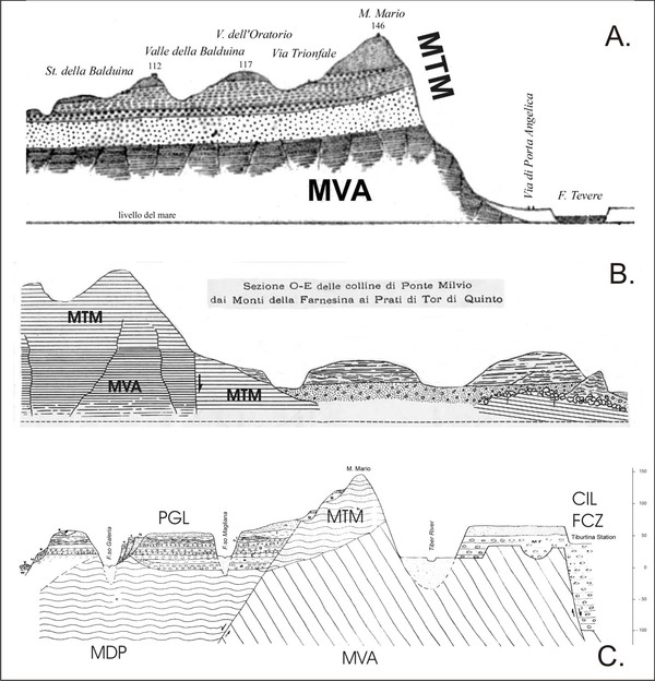
Figure 8. Geological cross-sections across Mt Mario
The three sections show the tectonics and the unconformity relationships between the Pliocene Monte Vaticano Fm. and the Lower Pleistocene Monte Mario Fm. A. Tellini (1896); B. Verri (1915); C. Conato et al. (1980).
Lower (Sicilian/Villafranchian)-Middle Pleistocene p.p. (Fig. 5c,d) - The marine domains extinguished progressively from east to west for the regional uplift of the area. The complete transition from marine to continental environments occurred between the late Lower and the early Middle Pleistocene, approximately between 850 and 700 ka, when the Roman area hosted the deltaic sedimentation from a paleo-Tiber river (Fig. 5c and 16 Ponte Galeria Fm. – PGL; Funiciello and Giordano, 2008, a,b).
The last phase of uplift of the NW-trending Mt. Mario structural high (Fig. 9), isolated the deltaic sedimentary wedge and forced the paleo-Tiber toward the south-east, parallel to the coast, inside a NW-trending subsiding valley wherein a thick succession of fluvial conglomerates was deposited (Manfredini, 1990; Feroci et al., 1990; Giordano et al., 2002), named the Fosso della Crescenza Fm. (Fig. 5d; FCZ; Funiciello and Giordano, 2008, a,b). The fluvial conglomerates of the Fosso della Crescenza fm. are found as deep as -100 m below sea level.
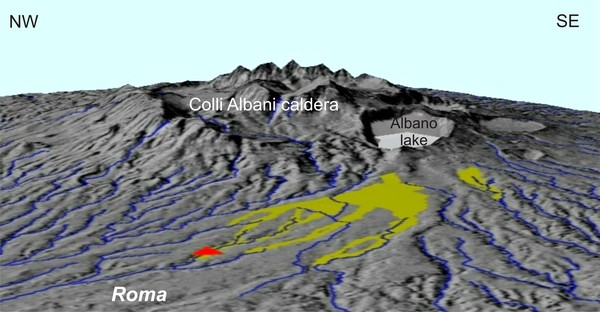
Middle p.p.-Upper Pleistocene (700-125 ka) (Fig. 5e,f) - As a consequence of the Tiber river diversion parallel to the coast, a large lake or swamp probably developed in the Colli Albani area, bearing an influence upon the early phreatoplinian activity of the volcano which started at about 600 ka (Pisolitic Tuffs succession; De Rita et al., 2002; Giordano et al., 2006, 2010). The growth of the Colli Albani volcano to the south (Fig. 10), and especially the early emplacement of the large volume ignimbrite sheets (600-355 ka; Giordano et al., 2006, 2010), progressively shifted the river back northward (after ca. 550 ka) approximately where the present day river has its course, where it cross-cut the Monte Mario-Gianicolo horst (likely captured by a minor valley cut on the west flank of the Monte Mario rise) to find its way to the reach the sea.
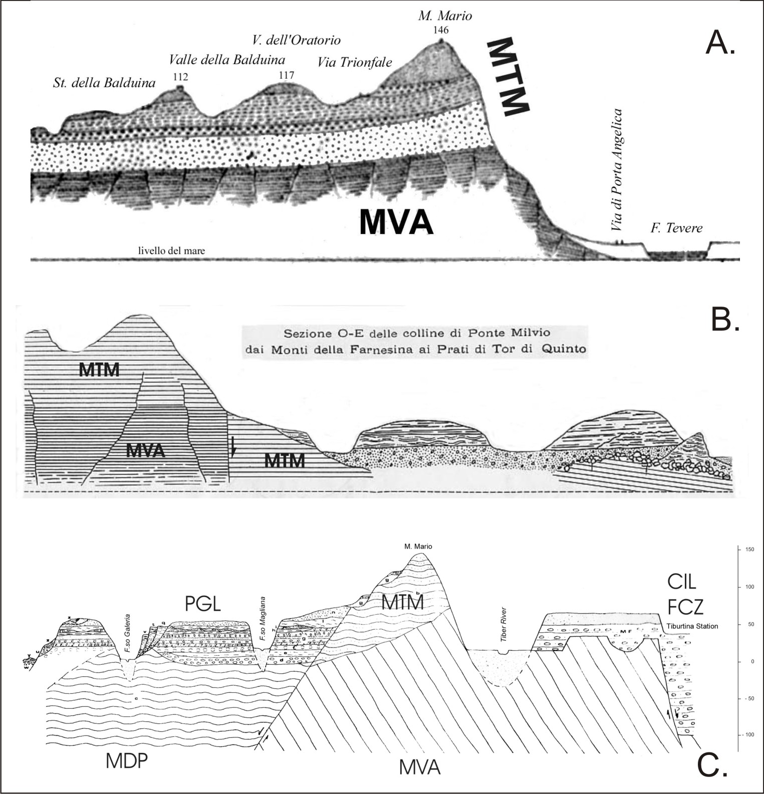
Figure 9. Geological cross-section across Monte Mario (from Cosentino et al., 2009)
This section was reconstructed from direct observation during the excavation for the Galleria Giovanni XXIII.
Contemporaneously, the Sabatini volcanoes to the north emplaced large volume ignimbrites, pushing the course of the Tiber river eastward near the Apennines (Funiciello and Giordano, 2008a,b; Parotto, 2008).
Last Glacial Age (Fig. 5g) - The volcanic activity at the Colli Albani and Sabatini volcanoes during this period was essentially phreatomagmatic forming several maars (Giordano et al., 2006, 2010; Giordano, 2008 and references therein). The progressive reduction of the erupted volumes, with the consequence of reducing considerably the production of volcanic debris, allowed the climate changes to have a stronger influence on the landscape evolution. During the last low stand of the sea level related to the Wűrmian glacial age, the Tiber river valley deeply eroded the volcanic and pre-volcanic rock succession down to the Pliocene clay units. The Campagna Romana assumed the present configuration with perched relics of the tabular volcanic plateau, which represent the present day topographic reliefs of Roma.
Figure 10. The Colli Albani volcano
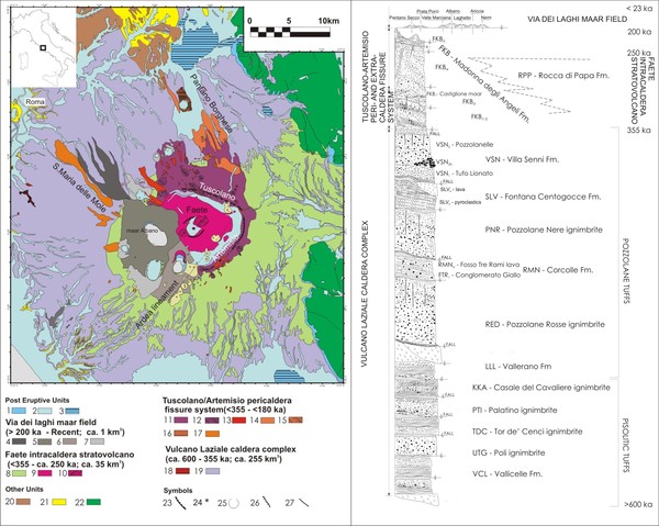
A. Geological map of the Colli Albani (modified after Giordano et al. 2010); B. Schematic stratigraphic column of the Colli Albani volcanic products.
Holocene (Fig. 5h) - The rise of the sea to the present level has induced the progressive filling of the Tiber river valley with its alluvial deposits, forming the alluvial plain closed to the west by the Monte-Mario-Gianicolo ridge, and, to the east, by the relics of the margin of the volcanic plateau, the famous Seven Hills of Roma (Fig. 4a,b).
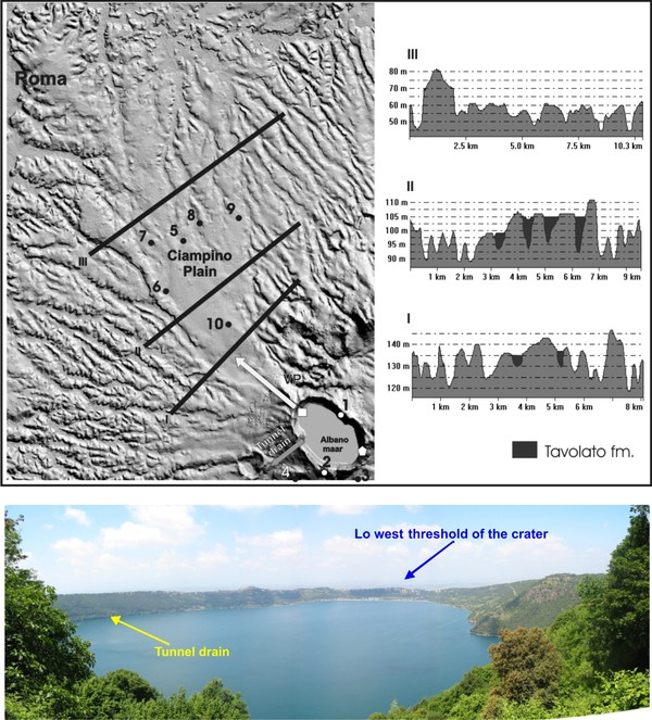
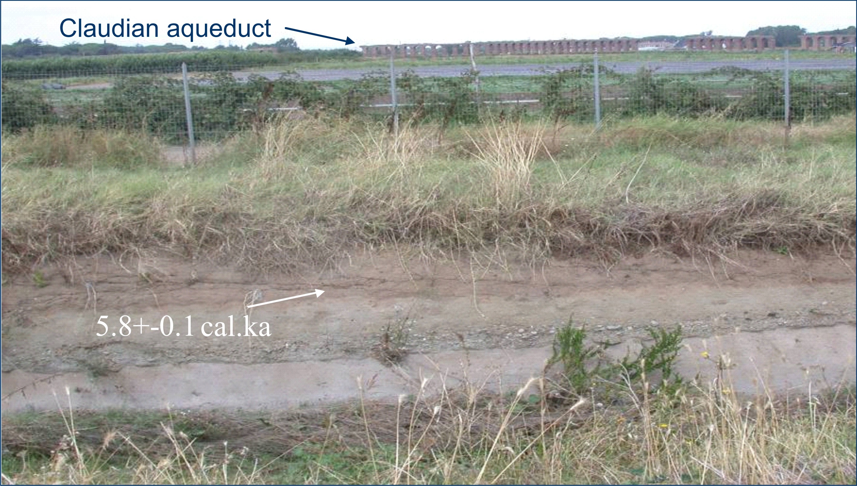
Recent studies have revealed that the large flat plain that extends northwestward from the Albano maar lake in direction of Roma, the Ciampino Plain, is been formed by the deposition during the Holocene of phreatomagmatic and lahar deposits from the most recent activity of the Albano maar (Fig. 11; Funiciello et al., 2002, 2003; Funiciello and Giordano, 2008a,b; Giordano et al., 2005, 2006, 2010; De Benedetti et al., 2008). The last episode of lake overflow occurred in the IV cent. B.C.E. (before common era) and induced the Romans to dig a tunnel to drain the lake which still today regulate the lake level 70 m below the crater rim (Fig. 12b). The Ciampino Plain has been later used as the path for all Roman aqueducts, changing forever the social perception of that area from the source of disastrous floods in the main water way to the city (Fig. 13).
Figure 11. The Ciampino laharic plain
3D perspective of the flat Ciampino plain, showing in green the distribution of the Holocene lahar deposits originated by the overflows of the Albano maar lake (picture courtesy of Antonia Arnoldus-Huyzendveld).
Figure 12. The Tavolato Formation and the historical overflows of the Albano maar lake
A. profiles across the Ciampino plain show the Holocene infilling of the Last-Glacial fluvial network by the lahar deposits of the Tavolato Fm. (from De Benedetti et al., 2008); B. View of the Albano lake with the location of the tunnel drain buikt by the Romans to keep the lake level 70 m below the lowest threshold of the crater rim, in order to prevent further overflows, the last having occurred in 398 B.C.E.
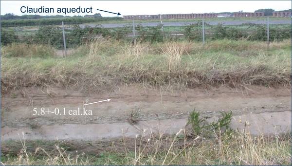
Figure 13. The flat top of the Tavolato Fm.
Note the aqueducts in the background, built by the Romans to use the top gently sloping toward the city (Via Appia-G.R.A.).