Water and building stones resources
Five hydrogeological units can be defined in the territory of Rome. These units overlie the hydrogeological complex of the Pliocene clayey-marly deposits that, given the considerable thickness, always larger then hundreds of metres, and the very low permeabilities, act as regional aquiclude (Fig. 14) (Capelli and Mazza, 2005). The local structural setting and the type of water exchange between units affect the hydrogeological setting and the scheme of movement of groundwater in the town area. The most interesting hydrogeological complexes are those characterized by high permeability and include the Ponte Galeria Fm., the Fosso della Crescenza Fm. and the S. Cecilia Fm. In addition to these, also the deposits of the Vulcano Laziale activity host important aquifers, especially in the south east, where such deposits, significantly extensive, have thicknesses of several tens to hundreds of meters. The morphological evolution following each main eruptive phase both from the Colli Albani and Sabatini volcanoes, has led to formation of alluvial successions presently terraced, in outcrop along the system of valleys which have been eroded during the Pleistocene low standing of the sea level. These deposits contain, generally at the base, gravel aquifer facies, confined above by mainly pelitic terms. These bodies, however extensive, do not constitute a single aquifer and their recharge is still object of study. During the twentieth century a thick and extensive layer of filling, due to the urbanization of the city of Roma, covered the natural rock-formations. These deposits host little aquifers linked to the zenithal recharge and the leakage of underground utilities.
Figure 14. Map of the hydrogeological units of the Roman area (from Capelli & Mazza, 2005).

Legend: 1 - Sabatini Mts. hydrogeological unit; 2 – Colli Albani hydrogeological unit; 3 - Ponte Galeria hydrogeological unit; 4 - Hydrogeological unit of Recent and present alluvial deposits; 5 - Tiber river delta hydrogeological unit; 6 - Hydrogeological system of low permeability clayey-marly deposits.
The Hydrogeological Map of Roma (Fig. 15) (Capelli et al., 2008b), allows to evaluate the relations between groundwater, and the drainage network, both natural and artificial, the latter consisting mainly of the sewer network that replaced the pre-existing river branches. Furthermore, the isophreatic lines, in addition to the identification of the main directions of groundwater flow, can identify the different gradients that characterize the groundwater circulation in different areas of the city. In the western area of the territory, to the west of the Tiber, the clayey structural high of Monte Mario, oriented NW-SE, affects the pattern of groundwater flow. The groundwater drainage of Monti Sabatini Hydrogeological Unit aquifer is affected by this structure, which acts as groundwater divide and splits the drainage partly to the south-west, towards the river Arrone, and partly to the west, towards the basins of the Fosso della Mola - Cremera Valchetta. The recharge of the Galeria and Magliana streams and the smaller basins is mainly due to the pre-volcanic sandy-gravel aquifers, belonging to the Ponte Galeria Fm.
To the east of the Tiber, the hydrogeological setting is different. There, the Colli Albani aquifer is less affected by the morphology of the clay substrate, which is more flat and deeper. The Colli Albani aquifer feeds copiously all stream valleys eroded down to the roof of the regional aquifer.
Essentially, the territory to the west of Tiber river is characterized by discharges of the streams mainly due to the surface runoff, whereas to the east of the Tiber, the river network is supported by base flow from the Colli Albani groundwater aquifer. Moreover, in the western part of the city the territorial changes resulting from urban changes have not determined the total disappearance of the river network, whereas in the eastern part, longly urbanized, the flillings and the transformation of talwegs in the sewerage network, led to the disappearance of valleys.
Surface waters have played in ancient times of Roma, and are still playing, a major role both as essential resource and hazard, because of recurrent floodings and the related unhealthy marshes and swamps.
The availability of surface water is related to the hydrogeological setting of Roma and its surroundings (Corazza and Lombardi, 1995; Capelli et al., 2005; Corazza et al., 2006; Capelli and Mazza 2008a; Capelli et al., 2008a;). To the west of Roma, the Apennine chain provides several high discharge springs associated with the highly permeable Mesozoic-Cainozoic limestone blocks thursted over the impervious Miocene terrigenous flysch (e.g. Boni et al., 1988).
The importance of surface waters for Roma is recorded in its foundational legend, when Romolo and Remo landed in the site of the future Roma in a basket, which had floated over the Tiber river. This legend must reflect the lively relationship between human settlements and water.
During the Empire, the 2 millions citizens of Roma had an amount of drinkable water per person per day equal to that of the most efficient (and lucky) modern cities. All the major springs along the Apennine mountains were captured and delivered to houses, thermae and fountains of Roma, with the edification of perched aqueducts hundreds of kilometres long, likely the most spectacular engeneering construction of that time. After the fall of the Empire, Roma experienced a rapid demographic decline and lost the technical expertise to keep in function the aqueduct network, which was restored only one thousand years later.
Figure 16. Ponte Galeria Formation

The Ponte Galeria Fm. (PGL) shows transition from pro-delta conglomerate and sand (PGL3a), to lagoonal clay (PGL3b), to aeolian sand (PGL3c). Here PGL is overlain by the S. Cecilia Fm. (CIL) bearing the first volcaniclastic deposits (> 600 ka).
Figure 17. Lithified ignimbrites as building stones

A. Quarries of the lithified ignimbrite Tufo Lionato (355 ka, erupted from Colli Albani) along the Aniene river. B. the use of blocks of lithified ignimbrites allowed the great development of Ancient Roman architecture; here the Servian walls and successive modifications at Roma Termini train station.
Aside water, the availability of a vast range of local building stones has certainly played a major role in promoting the excellence of Roma in history (Giampaolo et al., 2008 and references therein). A review of the geotechnical characteristics of the rocks of the Roman area can be found in the explanatory notes to the new 1:50.000 scale geological maps of Roma (sheet n. 374; Funiciello & Giordano, 2008a) and Albano (sheet n. 387; De Rita & Giordano, 2010) (see Bozzano 2008; Lanzini 2008, Diano, 2010)
The Pliocene shales of the Monte Vaticano Fm. have been longly quarried to produce bricks (Fig. 8), alongside, at least in early Roman times, with the clay from the Holocene alluvial deposits.
The conglomerate and sand of the Ponte Galera Fm. are still largely quarried (Fig. 16) for concrete.
The lithifed ignimbrites, both from Colli Albani and Sabatini (namely, the Tufo Giallo della Via Tiberina, the Tufo Giallo di Porta and the Tufo Rosso a Scorie Nere from the Sabatini, and the Unità di Tor de Cenci, Unità del Palatino, Tufo Lionato and the phreatomagmatic Peperino Albano from the Colli Albani; see Funiciello & Giordano, 2008b), have provided tuff blocks for walls (Fig. 17). The unconsolidated ignimbrites, mostly the Pozzolane Rosse, the Pozzolane Nere, and the Pozzolanelle units from the Colli Albani (Fig. 18; see Giordano et al., 2010), have been used mixed to cement to produce the hydraulic cement, a discovery which allowed the Romans, first in history, to build concrete peers in harbours.
Figure 18. The Pozzolane Tuffs succession

Succession of the main pozolanaceous ignimbrites of the Colli Albani, the Pozzolane Rosse (RED, 460 ka), Pozzolane Nere (PNR; 407 ka) and Pozzolanelle (VSN2; 355 ka) at Cava Bulgarini.
Both the lithified and the unconsolidated ignimbrites have been largely quarried underground (Fig. 19), producing a vast and still largely unexplored network of catacombs and undergound tunnels, which occasionally collapse affecting the edifices and infrastructures (Mazza et al., 2008 and references therein).
Figure 19. Roma underground
A. Tunnel excavated in the Tufo Lionato at Monteverde originally to extract building stones, have been re-inforced and longly used. Note also the vertical pole-foundation which have penetrated the tunnel from overlying constructions; B. Underground cavities used for mushroom-growing.
The K-foiditic to tephritic lavas have been quarried to form foundation of buildings and to pave roads, for their fine grained and compact texture which allows excellent resistance to compression and to friction (Fig. 18; see Diano, 2010).
The partly welded scorias from the Colli Albani scoria cones have been quarried for presenting similar characteristics to lava but in a less dense material (Fig. 20). This rock has been largely used in the Colosseum.
Figure 20. Building stones

Roman quarry at Tuscolo (Colli Albani caldera) where welded scorias (local name « sperone ») were quarried for buildings.
Finally the carbonatic rocks from the nearby Apennines, but most importantly the Tivoli travertine have been quarried since Roman times both as building and ornamental stones (Fig. 21).
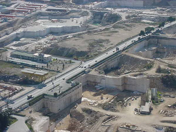
Figure 21. The Tivoli travertine
The quarries of Tivoli travertine have left a superelevated strip on which runs the Tiburtina road.